
Muggy Weekend Ahead
By Todd Nelson
To be honest, we really haven't had much to complain about so far this summer. Meteorologically speaking, June ended a little less than 1 degree above average in the temperature department and so far this July, temperatures are running nearly 4 degrees below average. There hasn't been a whole lot of humidity (yet) and we've only had one 90 degree day (92 degrees on June 9th). I can handle that!
According to NOAA's NCDC, the 1981-2010 average for number of 90 degree days or warmer in Minneapolis is around eleven and that average suggests that we should have already had four.
Climatologically, mid July is the warmest time of the year. Our average high peaks at 84 degrees until July 21st, then starts slowly dropping. However, the summer swelter can continue long into August before any noticeable cold fronts return in September.
If you're a fan of the heat, you'll get it this week as highs approach 90 degrees and humidity values begin to spike. Retreating to your favorite pool or lake might not be a bad idea. Late day thundershowers will be possible this weekend too, but it won't be a washout.
Summer is definitely here. Don't blink! -Todd Nelson
______________________________
WEDNESDAY NIGHT: Clear and mild. Low: 60. Winds: S10
THURSDAY: Mix of clouds and sun, still quite pleasant. Dew point: 58. High: 83. Winds: SSW 5-10
THURSDAY NIGHT: Mostly clear and quiet. Low: 64. Winds: S 5-10.
FRIDAY: More humid. Clouds thicken late. High: 83
SATURDAY: Warmer with sticky sun, late T-storm. Dew point: 66. Wake-up: 67. High: 86
SUNDAY: Hot sun, stray T-storms. Dew point: 73. Wake-up: 70. High: 90
MONDAY: Muggy. Stray thundershower? Wake-up: 70. High: 86
TUESDAY: Hazy sun, still very sticky. Dew point: 68. Wake-up: 65. High: 87
WEDNESDAY: Warm. Isolated afternoon thundershower. Wake-up: 66. High: 86.
_____________________________
This Day in Weather History
July 9th
1932: Tornado hits near Springfield to St. James, causing 500 thousand dollars in damage.
_____________________________
Average High/Low for Minneapolis
July 9th
Average High: 84F (Record: 99F set in 1976)
Average Low: 64F (Record: 48F set in 1895)
_____________________________
Sunrise/Sunset Times for Minneapolis
July 9th
Sunrise: 5:36am
Sunset: 9:00pm
_____________________________
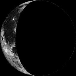
Moon Phase for July 9th at Midnight
1.4 Days After Last Quarter
__________________________________
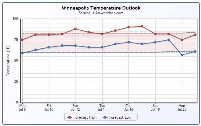
Minneapolis Temperature Trend
Although temperatures have been running cooler than average this week, it hasn't felt too bad. Low humidity and sunshine can go a long way in July... hope you're enjoying it! Temperatures look to gradually warm through the rest of the week/weekend into some slightly more uncomfortable weather. Highs will approach 90F with higher humidity, so it appears that we may be dealing with a little summer swealter through mid July. Stay tuned!
__________________________________
Thursday Weather Outlook
Temperatures will warm up a bit from where we were earlier this week. I could see highs reaching the lower 80s across much of the state and with a light southerly breeze, it should still be a very comfortable day!
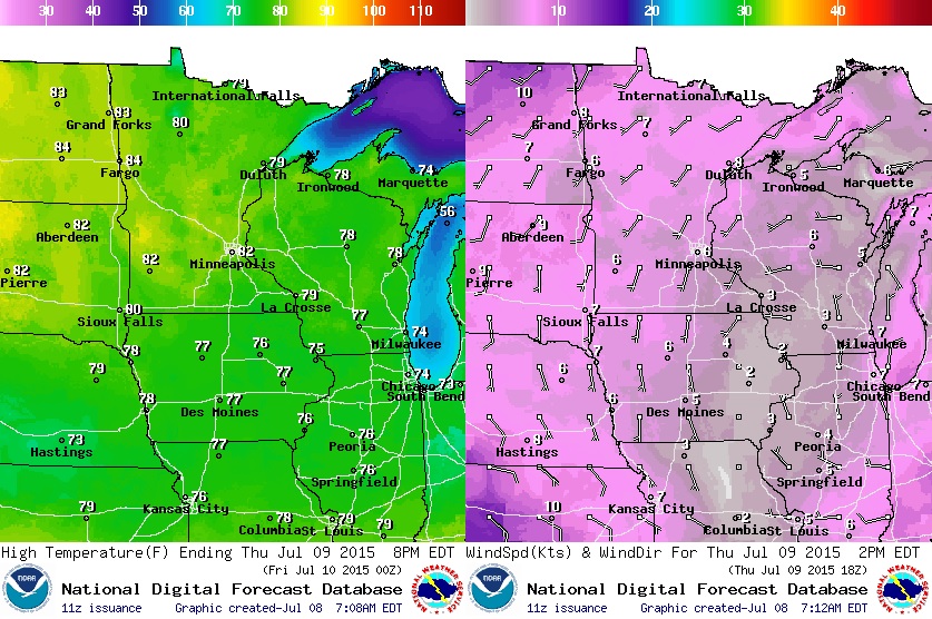
Thursday Weather Outlook
Other than a little thin vail of smoke from those Canadian wildfires, Thursday should be another very pleasant day with more sun and low humidity. Enjoy!
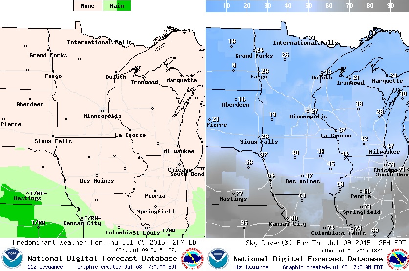
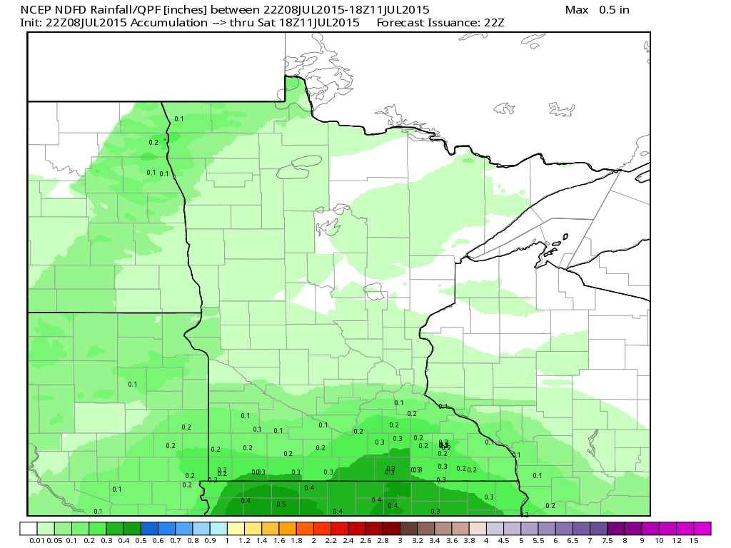
Rainfall Potential
Weather conditions through the end of the week across much of the state will remain dry. I don't see any major problem in regards to heavy rain through Friday. However, scattered showers and storms may develop during the afternoon/evening hours this weekend as warmer air begins to move into the region.
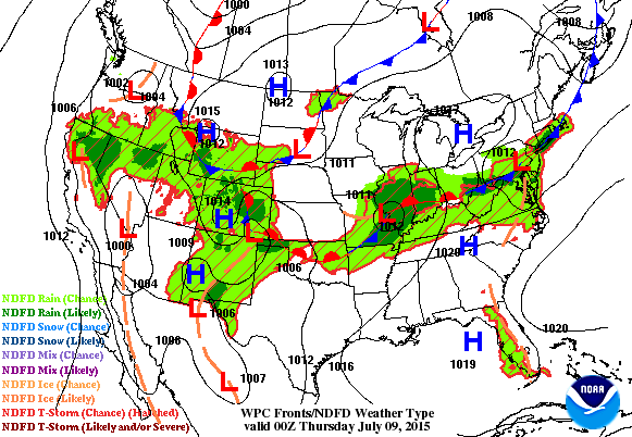
National Weather Outlook
The axis of heavy rain that fell across parts of the Central U.S. earlier this week will begin to fade. While a few lingering showers and storms can be expected through the end of the week. Rainfall tallies won't be as intense as they were earlier this week!
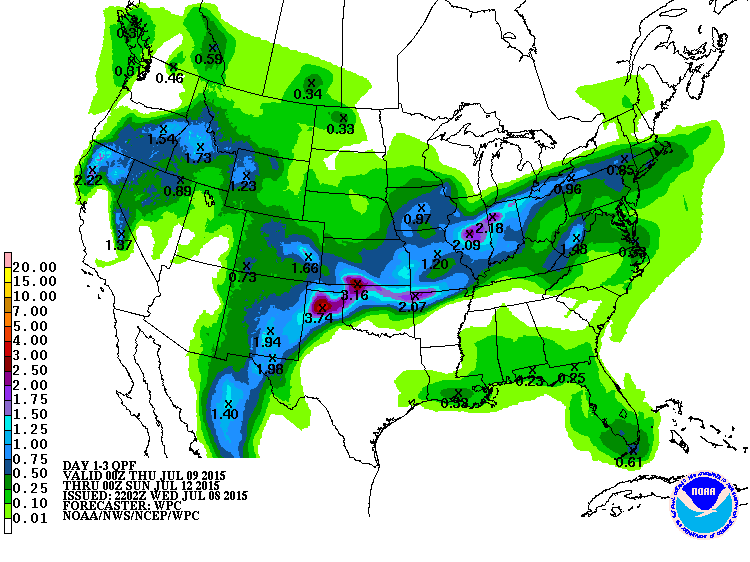
3 Day Precipitation Outlook
According to NOAA's WPC, the heaviest rainfall will be found across parts of the Plains to parts of the Ohio Valley with as much as 1" to 3" possible through Saturday. There will also be a few heavy pockets of rain in the Western U.S.
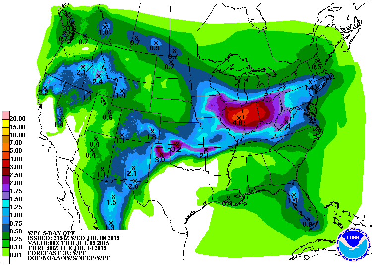
5 Day Precipitation Outlook
WOW! Look at that. Another round of heavy rain looks possible across parts of the Ohio Valley through early next week with as much as 2" to 4" or more, which may lead to more flood concerns. Also note the uptick in precipitation for folks in the Upper Midwest and Minnesota!
______________________________________
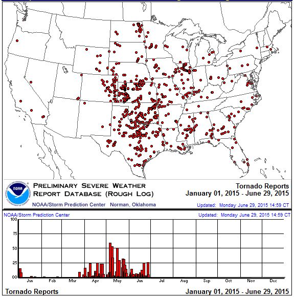
2015 Tornado Reports
Here's an interesting look at all the PRELIMINARY tornado reports from across the country so far this year. Note that most have occurred over the Central and Southern Plains.
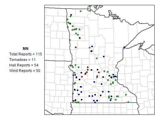
Minnesota Tornado Reports
Here's a plot of severe weather reports for 2015. Note that there have been 11 PRELIMINARY tornado reports so far this year. Interestingly, the 1991-2010 average suggests that we should have seen nearly 28 tornadoes through July 8th!
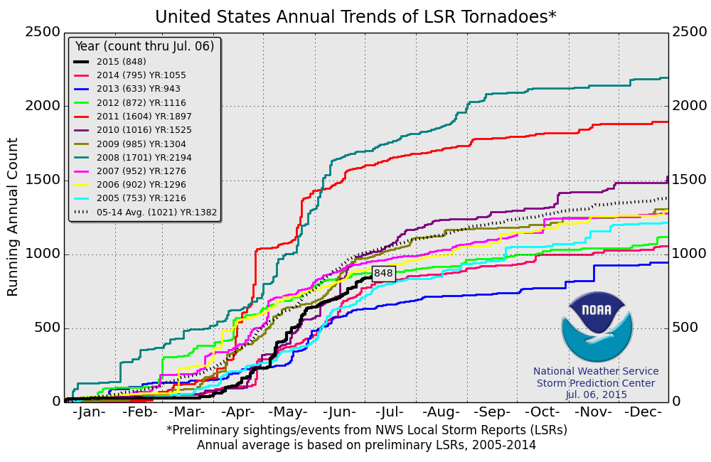
Tornado Report Comparison
According to NOAA's SPC, the 2015 PRELIMINARY tornado count is up to near 850 as of July 6th. Keep in mind that the 2005-2014 average through that date is 1,021, so we're running a bit behind the short-term average.
____________________________________________
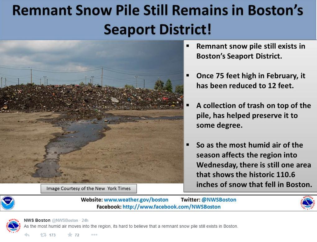
Snow Pile in Boston??
It's almost mid July and there's still snow in Boston? Give me a break! Check out this tweet from the National Weather Service out of Boston, MA:
See more from NWS Boston HERE:
____________________________________________
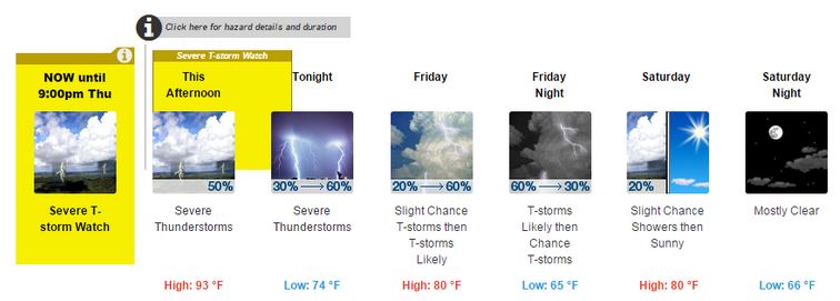
Changes to the National Weather Service Website
If you're a frequent visitor to the National Weather Service website, you may have noticed some changes this week. More noticeably will be the "Hazard boxes", which will highlight any hazardous weather in place in the extended forecast.
"On July 7, 2015, NWS implemented changes to the icons depicted on all of its point-forecast pages. Changes include new images with increased clarity, 6-hour increments for rapidly-changing weather (via "dual-icons") and new color blocks to highlight forecast hazards (via "hazard boxes"). Changes to the icons were based on analysis of 6,700 public comments collected in 2014. Also, many of these changes are based on the results of a research project led by the National Center for Atmospheric Research (Demuth, Lazo, & Morss, 2012; Demuth, Morss, Lazo, & Hilderbrand, 2013). Users are encouraged to continue to provide comments regarding these changes via email at icons@noaa.gov. NWS will continue to analyze incoming feedback and refine the icons as necessary. Any substantial change to the icons will be facilitated through the NWS public comment/review process."
See more from the NWS HERE:
___________________________________
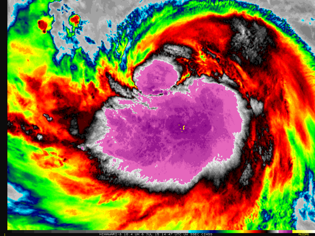
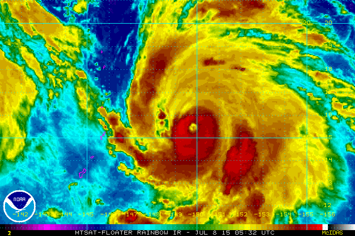
Active in the Pacific Ocean
The images below are quite striking. This is what Typhoon Nangka looked like earlier this week as it made its way closer to Guam in the Pacific Ocean.
"The Japanese Meteorological Agency is using Himawari-8 as its operational satellite, effective 0200 UTC on 7 July 2015. The animation above shows two days of water vapor imagery from Himawari-8 (6.2 µm, top, 6.9 µm, middle and 7.3 µm, bottom) over the tropical Pacific, revealing the train of three tropical cyclones moving westward towards Asia (testimony to why satellite data are important!). Typhoon Nangka, on the right, has developed an eye. Himawari-8 samples a full-disk image every 10 minutes, with nominal 2-km resolution in the infrared channels. Moveable sectors are also available at 2.5-minute intervals, such as shown in this animation from here. Himawari-8 has 0.5-km resolution in the 0.64 µm visible channel. A 3-hour animation over Typhoon Nangka, at routine 10-minute time-steps, is shown below."
See more from the CIMSS satellite blog here:
_________________________________
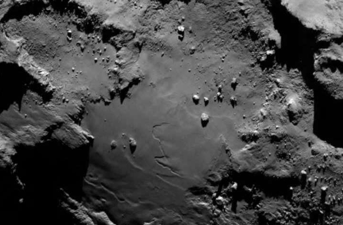
"Philae's Comet May Host Alien 'Life': Astronomers"
Here's an interesting read from news.discovery.com about a new theory on possible alien life on Philae's Comet...
"Astronomers proposed a novel explanation Monday for the strange appearance of the comet carrying Europe’s robot probe Philae through outer space: alien microscopic life. Many of the frozen dust ball’s features, which include a black crust over lakes of ice, flat-bottomed craters and mega-boulders scattered on the surface, were “consistent” with the presence of microbes, they said. Observations by the European Space Agency’s Rosetta comet orbiter has shown that 67P/Churyumov-Gerasimenko “is not to be seen as a deep-frozen inactive body, but supports geological processes,” Max Wallis of the University of Cardiff said in a statement issued by the Royal Astronomical Society (RAS). In fact, the comet racing towards the sun at a speed of 32.9 kilometers (20.4 miles) per second, “could be more hospitable to micro-life than our Arctic and Antarctic regions.”"
See more from news.discovery.com HERE:
__________________________________
Thanks for checking in and have a great rest of your week! Don't forget to follow me on Twitter @TNelsonWX

No comments:
Post a Comment