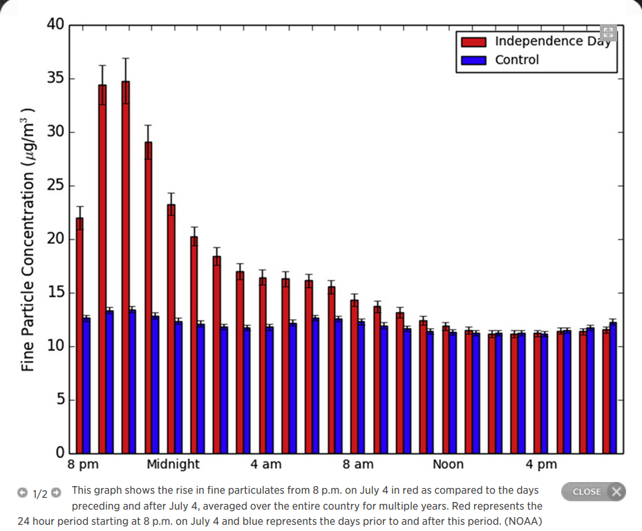
"Nationwide study measures short-term spike in particulate matter due to Independence Day fireworks"
Here's an interesting study from NOAA that shows a particularly high spike in air pollution due to fireworks!
"The new research shows that hourly concentrations of fine particulate matter typically reach their highest levels, when compared to the days before and after July 4, on the evening of July 4. Levels drop back down by noon on July 5, according to the research. On average, the increases are largest from 9-10 p.m. on the holiday. Average concentrations over the 24-hour period starting at 8 p.m. on July 4 are 42 percent greater than on the days preceding and following the holiday."
See more from NOAA HERE:
____________________________
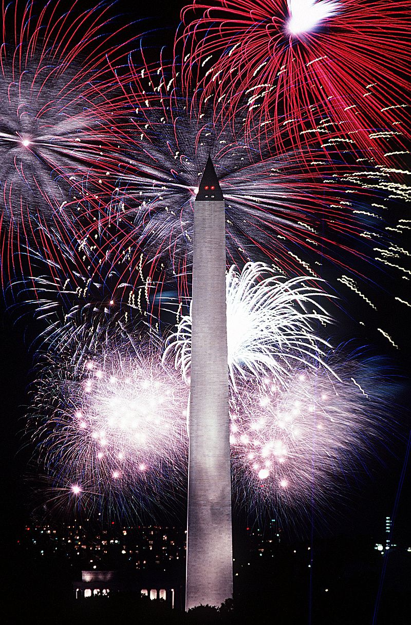
Happy 4th of July
By Todd Nelson
Somehow, the stars have aligned for what looks like a pretty spectacular 4th of July weekend! Don't be surprised if you find yourself 'sighing' with a meek smile at points Saturday or Sunday; it's OK, you deserve it!
Keep in mind that we're only 2 weeks removed from the Summer Solstice, so the sun is still very intense and UV index will be very high, meaning it will only take 15 minutes or less to get a burn.
Smoky sunrises and sunsets should be pretty neat this weekend too as several large wildfires continue across Canada, Northwest Territories and Alaska. Smoke plumes will drift south into the Upper Midwest with the heaviest concentration of smoke over Minnesota and Wisconsin Saturday and early Sunday.
It'll be a warm weekend, but it gets a little more humid on Sunday as a storm system approaches from Canada. Much of the region will start the day dry on Sunday, but the holiday weekend could conclude with some heavy downpours and strong thunderstorms, especially overnight.
Interestingly, a recent study from NOAA suggests a short-term spike in air pollution due to 4th of July fireworks; check the blog for more details.
Happy 4th!!
____________________________
FRIDAY NIGHT: Isolated rumbles ending early, otherwise partly cloudy. Low: 63. Winds: W 5
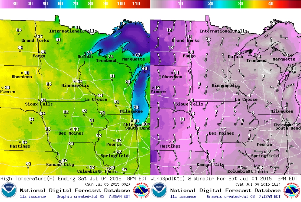
4TH OF JULY: Warm sunshine, dry. High: 84. Winds: S 10.
SATURDAY NIGHT: Warm and sticky - still dry. Low: 67
SUNDAY: Breezy. Sticky sun, T-storms at night. High: 86. Winds: S/SW 10-20.
MONDAY: AM T-showers, slow PM clearing. Wake-up: 67. High: 78
TUESDAY: Sunny, just about perfect with lower humidity. Wake-up: 60. High: 77
WEDNESDAY: Dry start, late day rumble. Wake-up: 62. High: 79
THURSDAY: Unsettled. Pockets of heavy rain. Wake-up: 63. High: 81.
FRIDAY: Feels like summer. Wake up: 65. High: 83.
___________________________
This Day in Weather History
July 4th
1999: Windstorm knocked down millions of trees in the BWCA, 19 people were injured.
1977: An intense squall line, or derecho, brought 115 mph winds to northern Wisconsin as the storms traveled from Minnesota to Lake Erie. A tremendous amount of forest was destroyed during the blowdown.
1962: Downpour at Jackson, where 7.5 inches of rain fell in two hours.
_____________________________
Average High/Low for Minneapolis
July 4th
Average High: 83F (Record: 101F set in 2012)
Average Low: 64F (Record: 43F set in 1972)
_____________________________
Sunrise/Sunset Times for Minneapolis
July 4th
Sunrise: 5:32am
Sunset: 9:02pm
_____________________________
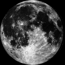
Moon Phase for July 4th at Midnight
3.6 Days Before Last Quarter
_______________________________
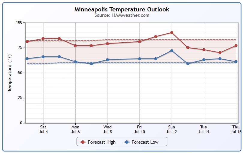
Minneapolis Temperature Trend
It really has been an incredible stretch of weather as of late. While temperatures for the first few days of July have been running cooler than average, it hasn't been anything to complain about. Temperatures for the month of June ended up only 0.8F above average and we've only seen one +90F temperature reading so far this year (92F on June 9th). Looking at the temperatures ahead, I still don't see any major heat waves brewing close to home. In fact, the forecast keeps us pretty seasonal through much of next week!
__________________________________
Saturday: 4th of July Weather Outlook
Saturday, July 4th will likely end up being one of warmest days for the first half of July. Temperatures across the state should warm into the 80s with cooler readings expected along the North Shore. I expect lots of boat traffic and picnics on Saturday with the weather being as nice as it's going to be! Enjoy
Saturday: 4th of July Weather Outlook
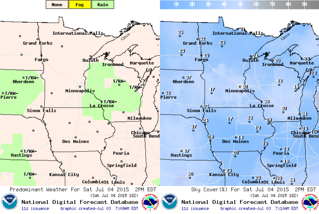
There may be a (spotty) afternoon rumble of thunder across parts of Wisconsin and far southeastern MN, but don't cancel any plans; It should only be brief if any develops. Sun
______________________________________
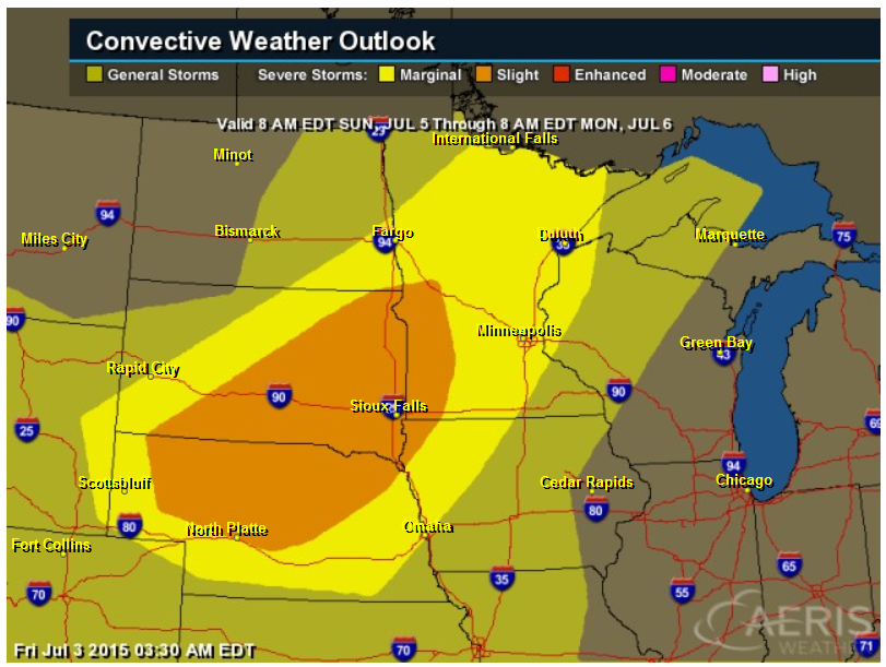
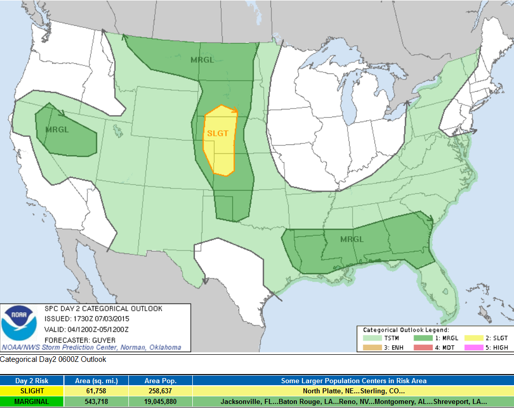
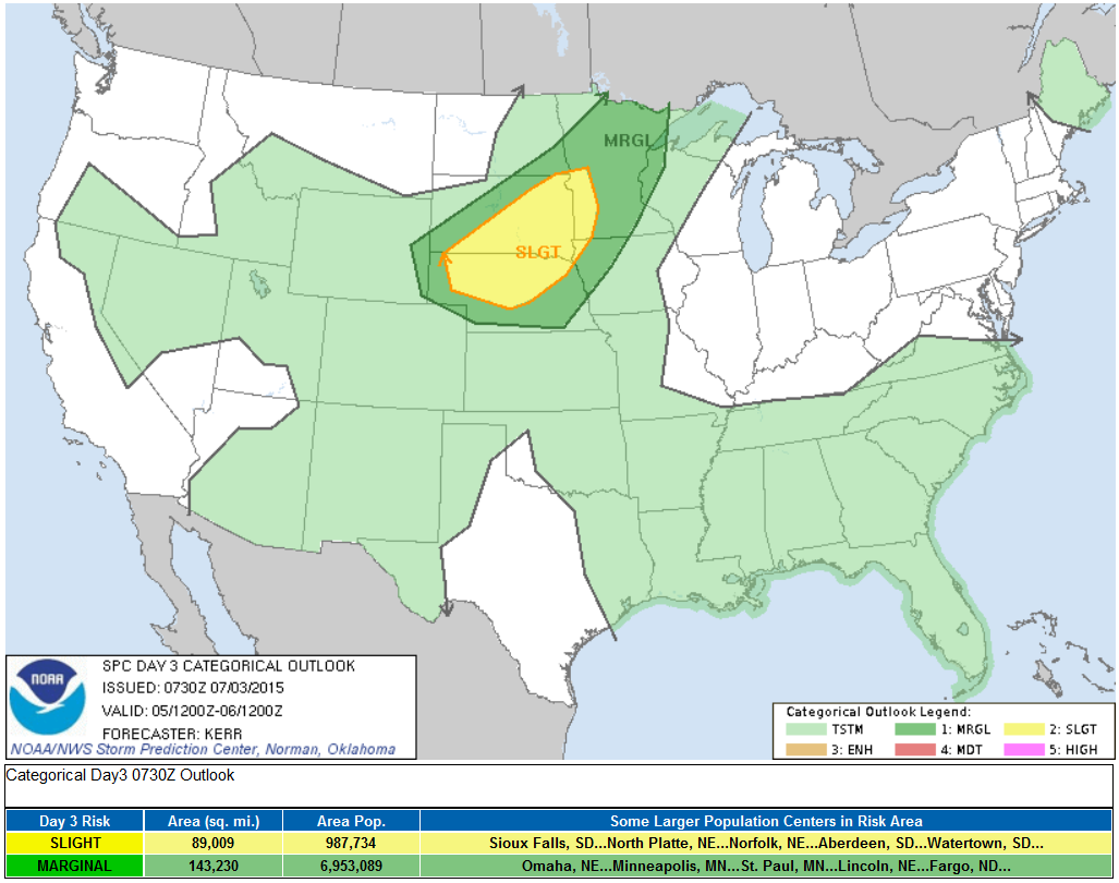
SUNDAY Severe Threat
The Storm Prediction Center has issued a SLIGHT RISK of severe weather across parts of the Midwest for late Sunday. A cool front will slide out of Canada late weekend and bring some late day showers and storms across the region. The end of your holiday weekend could end with a bang, stay tuned for further updates!
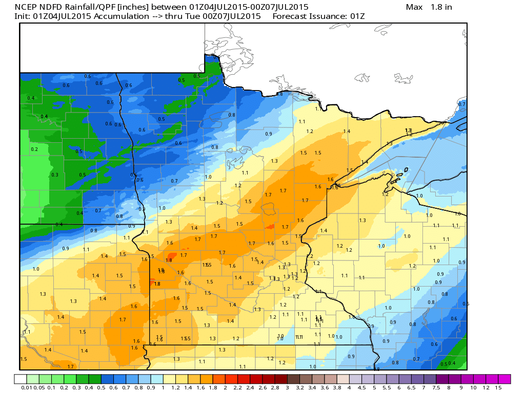
Rainfall Potential
As the front slides out of Canada late this weekend, showers and storms will develop and slide into the Upper Midwest. Rainfall tallies could be heavy in pockets with as much as 1" to nearly 2" possible in spots through PM Monday.
__________________________________________
National Weather Outlook
As we head through the holiday weekend, scattered showers and storms look to impact 4th of July celebrations across the the Gulf Coast States and perhaps across parts of the Four Corners and High Plains. Other than that, it looks like a pretty tame weekend ahead for most!
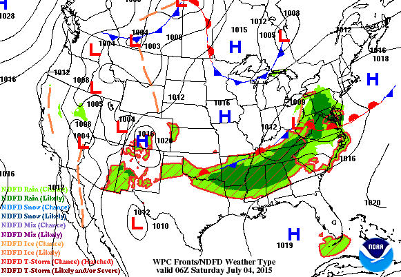
5 Day Precipitation Outlook
According to NOAA's HPC, the 5 day rainfall forecast suggests several pocket of heavy rain along and east of the Rockies through midweek next week. The heaviest looks possible over parts of the Plains with as much as 4" or more!

Severe Threat Saturday
...SUMMARY... SCATTERED STRONG STORMS WILL POSE A RISK FOR SEVERE WIND GUSTS AND HAIL ON SATURDAY...THE 4TH OF JULY...MAINLY DURING THE AFTERNOON AND EVENING HOURS ACROSS PARTS OF THE LOWER MISSISSIPPI VALLEY...THE NORTHERN AND CENTRAL HIGH PLAINS...AND THE GREAT BASIN. ...SYNOPSIS... SPLIT UPPER-LEVEL FLOW WILL PREVAIL OVER THE CONUS ON SATURDAY JULY 4TH. IN THE SOUTHERN STREAM...A MODERATE BELT OF WESTERLIES WILL ACCOMPANY A SLOW-EASTWARD-MOVING UPPER LOW OVER THE LOWER MS RIVER VALLEY/SOUTHEAST STATES...WHILE THE UPPER RIDGE ABATES OVER THE GREAT BASIN. A STRONGER NORTHERN STREAM WILL BE HIGHLIGHTED BY AN AMPLIFYING UPPER TROUGH OVER THE CANADIAN ROCKIES/PRAIRIES...WHICH WILL RELATE TO A SOUTHEASTWARD-MOVING FRONT INTO PORTIONS OF MT/DAKOTAS SATURDAY NIGHT. ...CENTRAL/SOUTHERN HIGH PLAINS... THE TIMING OF WEAK MID-LEVEL PERTURBATIONS ON THE PERIPHERY OF THE CENTRAL/SOUTHERN ROCKIES UPPER RIDGE STILL REMAINS UNCLEAR. HOWEVER...CURRENT THINKING IS THAT AT LEAST ISOLATED/WIDELY SCATTERED STRONGER THUNDERSTORMS SHOULD DEVELOP SATURDAY AFTERNOON/EARLY EVENING MAINLY IN VICINITY A NORTH-SOUTH SURFACE TROUGH. ALTHOUGH LOW/MID-TROPOSPHERIC WINDS WILL GENERALLY BE WEAK...AMPLE VEERING WITH HEIGHT AND STRONG HIGH-LEVEL NORTHWESTERLY WINDS WILL SUPPORT SOME SUPERCELLS SATURDAY LATE AFTERNOON/EVENING IN THE PRESENCE OF MODERATE /2000+ J PER KG/ MLCAPE. IT IS CONCEIVABLE THAT ONE OR MORE SOUTH-SOUTHEASTWARD-MOVING MCS/S COULD EVOLVE SATURDAY EVENING WITH AID OF A NOCTURNALLY STRENGTHENING LOW-LEVEL JET. ADDITIONAL PORTIONS OF THE REGION...POTENTIALLY INCLUDING MORE OF WESTERN KS AND PARTS OF THE TX PANHANDLE/WESTERN OK...COULD WARRANT A SLIGHT RISK UPGRADE IN THE DAY 1 TIME FRAME PENDING A GREATER CONFIDENCE IN STORM COVERAGE/SUSTENANCE IN AN ENVIRONMENT OTHERWISE RELATIVELY FAVORABLE FOR ORGANIZED STORM MODES. ...MT/ND... RELATED TO THE SYNOPSIS-DESCRIBED TROUGH AMPLIFICATION...UPPER HEIGHT FALLS WILL BEGIN TO SPREAD SOUTH OF THE INTERNATIONAL BORDER BY SATURDAY NIGHT. A SURFACE TRIPLE POINT WILL BECOME INCREASINGLY ESTABLISHED ACROSS THE NORTHERN HIGH PLAINS SATURDAY AFTERNOON/EVENING VIA AN EASTWARD-MOVING FRONTAL WAVE...SHARPENING PRE-FRONTAL TROUGH...AND SOUTHEASTWARD-MOVING FRONT ACROSS MT/WESTERN ND. AT LEAST ISOLATED STRONG/SEVERE THUNDERSTORMS COULD DEVELOP/MOVE SOUTHEASTWARD INTO THE REGION SATURDAY AFTERNOON/EVENING...WITH SEVERE HAIL/LOCALLY DAMAGING WINDS A POSSIBILITY. PARTS OF NORTHEAST MT INTO ND COULD WARRANT AN UPGRADE TO SLIGHT RISK IN THE DAY 1 PERIOD. ...LOWER MS RIVER VALLEY/SOUTHEAST STATES... WEAK HEIGHT FALLS AND A BELT OF MODERATELY STRONG/SEMI-COOL CYCLONIC FLOW ALOFT WILL LARGELY COINCIDE WITH AN EFFECTIVE FRONTAL ZONE REGULATED BY PRIOR CONVECTIVE OUTFLOWS/DIFFERENTIAL HEATING. A GRADUAL INCREASE/INTENSIFICATION OF EAST-SOUTHEASTWARD-MOVING THUNDERSTORMS SEEMS PROBABLE BY MIDDAY/EARLY AFTERNOON SATURDAY. SOME SEMI-ORGANIZED CLUSTERS MAY EVOLVE...WITH LOCALLY DAMAGING WINDS BEING THE PRIMARY CONCERN SATURDAY AFTERNOON THROUGH EARLY/MID-EVENING. ...GREAT BASIN... A BELT OF MODESTLY STRONGER SOUTHERLY MID/HIGH-LEVEL WINDS WILL OVERSPREAD THE REGION IN CONJUNCTION WITH A WEAKENING UPPER RIDGE. A DIURNALLY HEATED/WELL-MIXED BOUNDARY LAYER WILL CONTRIBUTE TO THE DEVELOPMENT/INTENSIFICATION OF THUNDERSTORMS SATURDAY AFTERNOON/EARLY EVENING MOSTLY ACROSS NV. DOWNBURSTS AND POSSIBLY SOME HAIL /MOSTLY SUB-SEVERE/ CAN BE EXPECTED WITH THE STRONGER STORMS.
Severe Threat Sunday
...SUMMARY... THUNDERSTORMS CAPABLE OF PRODUCING SEVERE WIND AND HAIL ARE EXPECTED SUNDAY ACROSS PARTS OF NEBRASKA...SOUTH DAKOTA AND ADJACENT PORTIONS OF SOUTHWESTERN MINNESOTA. ...SYNOPSIS... LITTLE CHANGE TO THE GENERAL UPPER FLOW PATTERN APPEARS LIKELY FROM SATURDAY INTO SUNDAY. SUBTROPICAL RIDGING APPEARS LIKELY TO REMAIN SOMEWHAT SUPPRESSED...BUT THE STRONGER MID-LATITUDE WESTERLIES ARE EXPECTED TO REMAIN CONFINED TO THE NORTHERN TIER OF THE U.S...NORTHWARD. WITHIN THIS REGIME A POSITIVELY TILTED TROUGH IS FORECAST TO CONTINUE PROGRESSING EASTWARD ACROSS THE CENTRAL CANADIAN PROVINCES. ON ITS TRAILING SOUTHWESTERN FLANK...A SMALLER SCALE PERTURBATION MAY DIG ACROSS THE INTERNATIONAL BORDER INTO THE NORTHERN PLAINS BY THE END OF THE PERIOD. AN ASSOCIATED COLD FRONT LIKELY WILL ADVANCE SOUTHWARD TO THE LEE OF THE NORTHERN AND CENTRAL ROCKIES...AND EASTWARD ACROSS THE NORTHERN PLAINS...INTO PORTIONS OF THE UPPER MISSISSIPPI VALLEY AND MID MISSOURI VALLEY BY 12Z MONDAY. A CORRIDOR OF STRONG DESTABILIZATION AHEAD OF THIS FRONT IS EXPECTED TO PROVIDE THE FOCUS FOR THE PRIMARY CONVECTIVE POTENTIAL SUNDAY AFTERNOON INTO SUNDAY EVENING. THIS INCLUDES THE RISK FOR SEVERE STORMS CAPABLE OF PRODUCING LARGE HAIL AND POTENTIALLY DAMAGING WIND GUSTS. ...NORTH CENTRAL PLAINS INTO UPPER MISSISSIPPI VALLEY... DUE TO THE ORIENTATION OF THE UPPER TROUGH...MODELS ARE SUGGESTIVE THAT PRE-FRONTAL MID/UPPER FLOW AND DEEP LAYER SHEAR MAY NOT BECOME PARTICULARLY STRONG. HOWEVER...STEEPENING MID-LEVEL LAPSE RATES ASSOCIATED WITH THE NORTHEASTWARD ADVECTION OF VERY WARM ELEVATED MIXED LAYER AIR...COUPLED WITH PRE-FRONTAL BOUNDARY LAYER MOISTENING...ARE EXPECTED TO CONTRIBUTE TO STRONG DESTABILIZATION WITH DAYTIME HEATING. BY LATE AFTERNOON...MIXED LAYER CAPE OF 2000-3000+ J/KG APPEARS LIKELY...PARTICULARLY ACROSS CENTRAL AND NORTHERN NEBRASKA...AND SOUTHERN/EASTERN SOUTH DAKOTA INTO ADJACENT AREAS OF MINNESOTA. WITH THE ONSET OF MID-LEVEL HEIGHT FALLS AND COOLING...INHIBITION IS EXPECTED TO WEAKEN SUFFICIENTLY TO SUPPORT THE INITIATION OF VIGOROUS STORM DEVELOPMENT ACROSS PARTS OF THE NORTHERN NEBRASKA PANHANDLE INTO SOUTHWEST AND CENTRAL SOUTH DAKOTA. THERMODYNAMIC PROFILES ARE EXPECTED TO BE CONDUCIVE TO SEVERE WIND GUSTS AND HAIL IN STRONGER ACTIVITY AS IT SPREADS EASTWARD. STORMS MAY ALSO DEVELOP NORTHEASTWARD ALONG/AHEAD OF THE FRONT INTO WEST CENTRAL...PERHAPS NORTHERN...MINNESOTA...BY EARLY EVENING. HOWEVER...STRONGER LOW-LEVEL WARM ADVECTION MAY SUPPORT MORE PROMINENT CONVECTIVE DEVELOPMENT ACROSS THE REMAINDER OF SOUTHERN SOUTH DAKOTA AND NORTHERN NEBRASKA...WHERE A CONSOLIDATING/STRENGTHENING SURFACE COLD POOL MAY EMERGE WITH AN EVOLVING CLUSTER OF STORMS.
_____________________________________
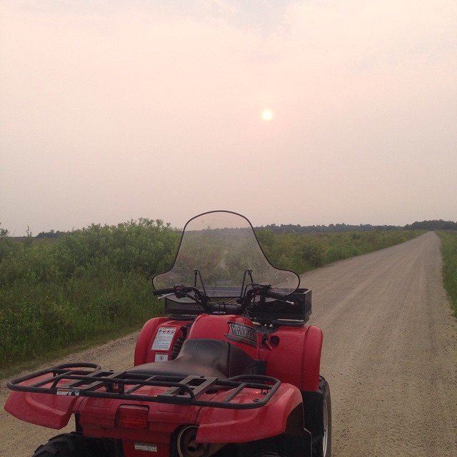
Smoky Sun
Thanks to Jackie Koch for the picture below taken in northern Minnesota Thursday evening. Thanks to several Canadian wildfires, smoke continues to spill south into the Upper Midwest. This may make for some spectacular sunrises/sunsets through the weekend!
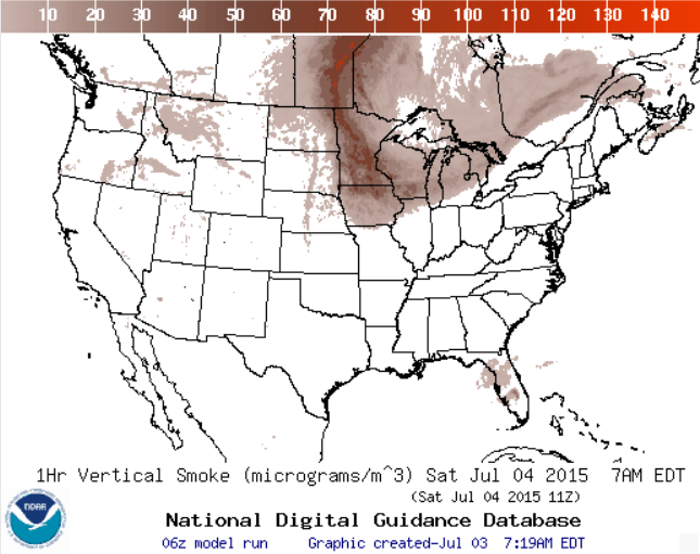
Smoke Analysis: 7am SATURDAY
The image below from NOAA suggests the smoke analysis for 7AM Saturday. Note how widespread the smoke appears to be across the Upper Midwest. Saturday's sunrise and sunset will appear a little more 'smoky' than what Sunday's sunrise/sunset will be.
__________________________________________
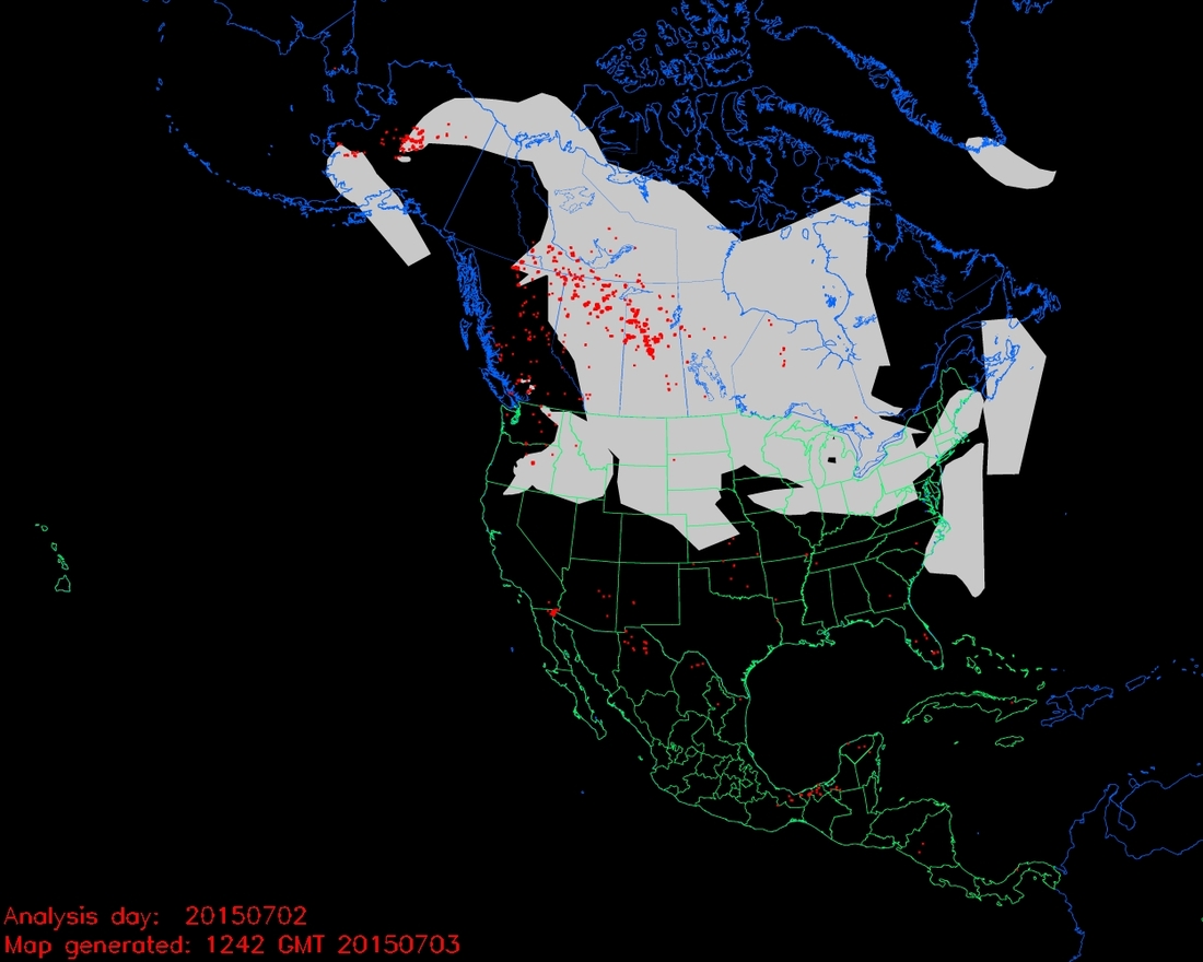
Canadian Fires and Smoke Analysis
Here's an interesting view of how widespread the wildfires (red dots) are across Canada and Alaska. The grey plumes are areas of smoke, which stretch all the way to the Northeast!
Visible Satellite of Smoke
Here's a visible satellite image of smoke across the Northwest Territories and Canada.
Canada is reeling from an early fire season this year as dozens of fires ravage at least three provinces of the country. This natural-color satellite image was collected by the Moderate Resolution Imaging Spectroradiometer (MODIS) aboard the Terra satellite on July 1, 2015. Actively burning areas, detected by MODIS’s thermal bands, are outlined in red. NASA image courtesy Jeff Schmaltz, MODIS Rapid Response Team. Caption: NASA/Goddard, Lynn Jenner
See the full report from NASA HERE:

_________________________________
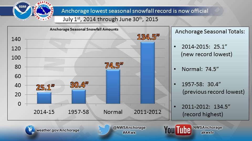
Anchorage, AK Lowest Seasonal Snowfall on Record
Part of the reason for all the wildfires in Alaska is because of the lack of snow this season. Take a look at the new record in Anchorage, AK.
It's official! The 2014-2015 snow season came to a conclusion. Anchorage officially set a record for its lowest seasonal snowfall on record with 25.1" of snow, breaking the previous record of 30.4" in 1957-58.
See more from the National Weather Service HERE:
Thanks for checking in and have a great weekend! Don't forget to follow me on Twitter @TNelsonWX

No comments:
Post a Comment