87 F. high in the Twin Cities Monday.
84 F. average high on July 13.
78 F. high on July 13, 2014.
4.76" rain so far in July.
1.67" average July rainfall, to date.
+3.09" departure from normal.
Darwin AwardSunday evening I failed an impromptu IQ test, which may not come as much of a shock.
A
tornadic storm was bearing down on our cabin near Nisswa; trees were
bending over horizontally; you could hear branches snapping off above
the roar of the wind. 5-foot whitecaps on the lake looked like
mini-tsunamis, shredding our dock. I don't have a basement so I did the
next best thing: I stood on the deck, hanging on in defiant amazement -
speechless, as nature put on a spectacle no Disney theme park or IMAX
movie will ever match.
Not one of my smarter moves. We had tree
damage but got off easy compared to so many homeowners nearby. And it's
hard posting online weather updates with no power.
Anyone with a
pulse knew that severe weather was likely. But then chaos theory kicked
in: there's no way to predict which towns, which homes will be hit the
hardest. There never will be. As I've said in the past it's an unholy
Lotto - the tiny minority of people impacted (severely) while the rest
of us look on in sympathy, thanking our lucky stars.
Sunday
night's storm seems to fit the definition of a derecho, at least a 240
mile (continuous) damage path. The same supercells that spawned
tornadoes near Fergus Falls mutated into straight-line wind storms that
congealed into one of these rare, boomerang-shaped storms that is
associated with widespread wind damage.
All you can do is hunker down - and stay off your deck!
A
lonely pop-up thundershower is possible this afternoon, but less than
10 percent of us will get wet and this time they probably won't be
severe. More widespread storms arrive
Thursday; by
Saturday temperatures may be pushing into the mid-90s.
Get ready a hot, stuffy, occasionally stormy rest-of-July.
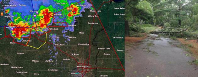
* photo upper right courtesy of @msppio_ne.
Tracking Two Distinct Supercells.
The severe rotating storms that spawned a couple of tornadoes from
Wilkin county into Fergus Falls seemed to split; one cell tracking
toward Wadena and Brainerd, the other divebombing southeast down I-94
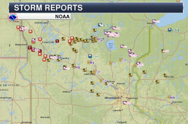
toward the Twin Cities. The Brainerd Lakes area may have seen the worst
damage, straight-line winds blowing over countless trees - that count
may rise into the thousands as clean-up crews get a better extent of the
damage. A complete listing of damage is
here, courtesy of the National Weather Service.
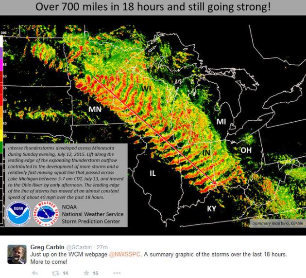
Derecho?
It may be a close call whether Sunday night - Monday's storm fits the
definition of a derecho. Did it last long enough, traveling far enough?
Greg Carbin at NOAA's SPC, the Storm Prediction Center, shows a
composite mosaic of the boomerang-shaped swirl of severe storms racing
southeward from Brainerd and the Twin Cities to Madison, Chicago,
Indianapolis, reaching Louisville by middday Monday. Amazing.
* According to NOAA SPC it would appear that Sunday night's storm
fits the definition of a derecho.
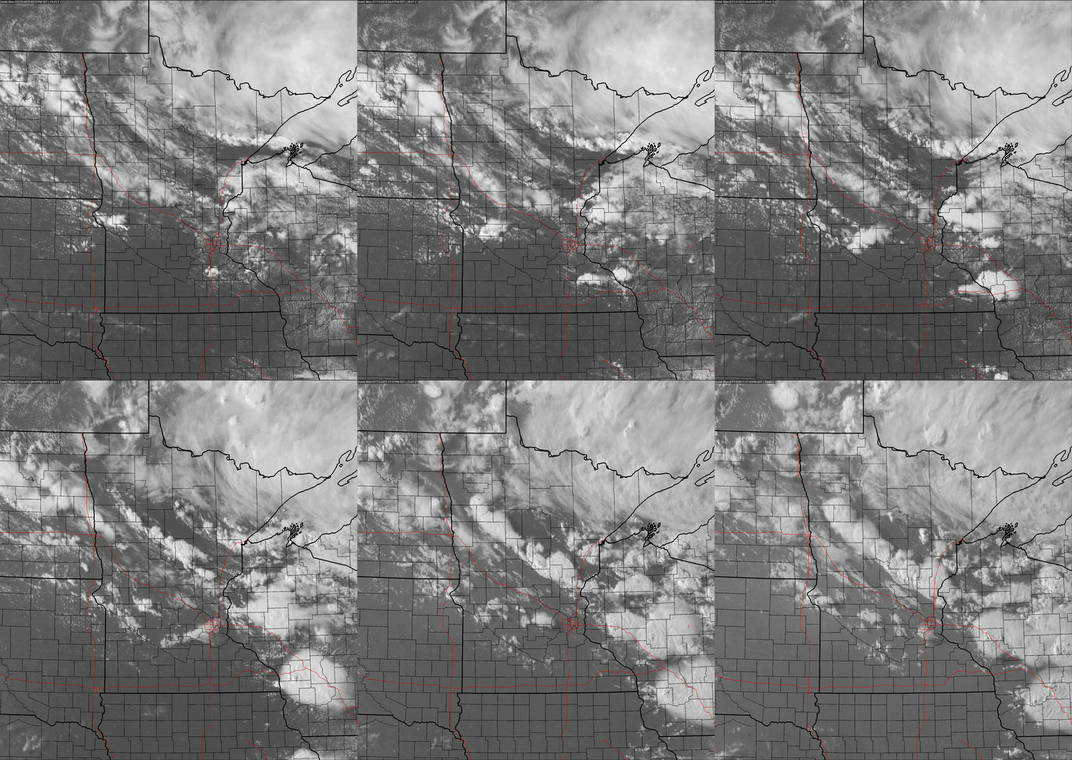
An Irritable Sky.
Although not as extreme as Sunday, there was sufficient instability for
more thunderstorms to mushroom over central Minnesota and then drift
south. The most severe storms blew up across Wisconsin, where a severe
storm watch was posted. Monday evening loop: NOAA and AerisWeather.
Thursday:
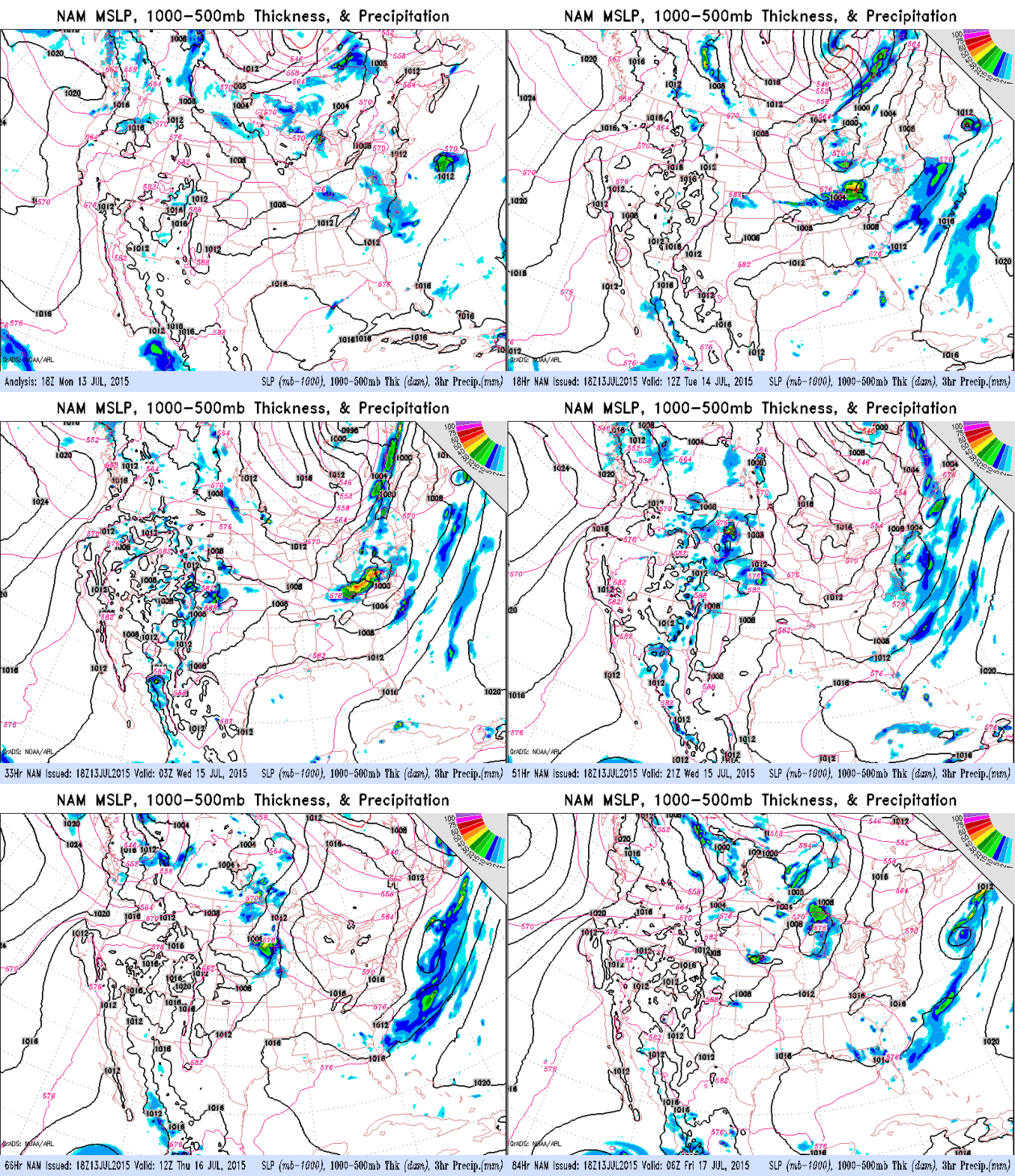
Next Chance of Heavy T-storms. NAM guidance shows an isolated T-shower
risk today, mainly Red River Valley, but the next chance of widespread,
potentially heavy showers and T-storms will come Thursday. 84-hour
guidance: NOAA.
Sloppy
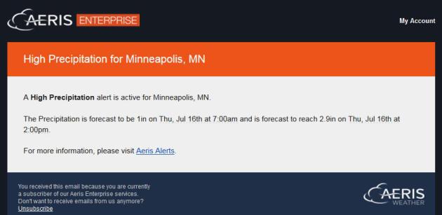
Thursday Blues. Based on GFS and NAM guidance a couple inches of rain
may fall close to MSP Thursday. 12 KM NAM guidance prints out 1" of rain
by 7 AM Thursday with a total of 2.9" by afternoon. I'll believe it
when I see it - I think the models are exaggerating how much rain will
fall Thursday. Source: AerisWeather.
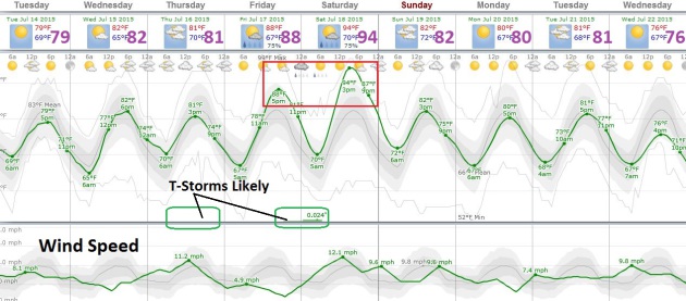
Seasonably Warm With A Few Hot Spikes.
Temperatures cool off to near normal today into Thursday, followed by
another warm-up late in the week. ECMWF and GFS guidance are both
predicting mid-90s, followed by slight relief Sunday.
Toasty, Not Char-Broiled.
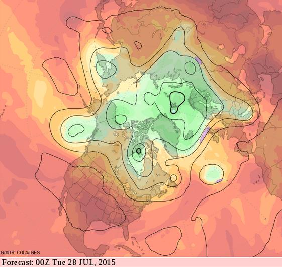
Long-range GFS model guidance shows a persistent bubble of high
pressure elevating temperatures from the southwest into the southern and
central Plains in about 2 weeks. Enough cool air will hiccup out of
Canada to prevent extended heat waves over the northern tier states
anytime soon. Source: GrADS:COLA/IGES.
Twin Cities Air Pollution Linked To 2,000 Deaths A Year. In case you missed the story at
The Star Tribune here's an excerpt and link to the entire article: "...
Air
quality in Minnesota is generally good and meets current federal
standards. But even low and moderate levels can contribute to illness
and early death. The report, jointly produced by the health department
and the Minnesota Pollution Control Agency, estimated that 6 to 13
percent of all deaths and 2 to 5 percent of all hospital visits were
aggravated by small particle and ozone pollution, the two types of air
pollution that cause the greatest health risk..."
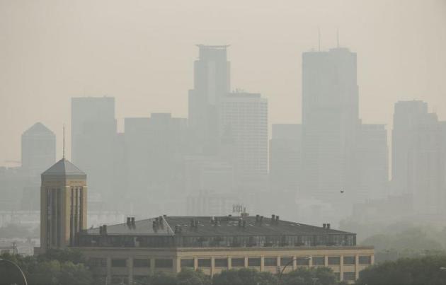
Photo credit above: Jeff Wheeler – Star Tribune. "
A
haze settled in over the Minneapolis skyline one day in early July as
smoke from Canadian wildfires drifted across Minnesota, leading to air
quality warnings."
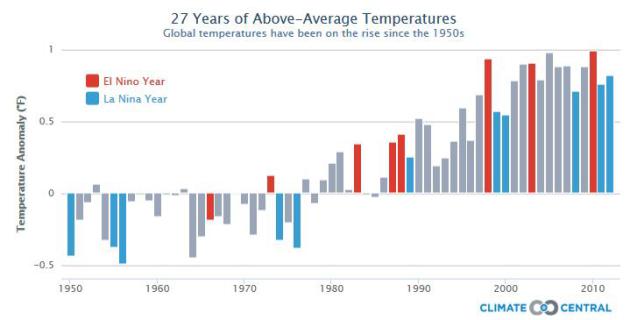
Global Temperature Anomaly Highest Since 2009-2010. Call me crazy but I see a trend.
International Business Times has a story that made me do a double-take; here's an excerpt: "...
Twelve-month
averages of global temperatures relative to 1981-2010 reached a value
in June 2015 that is comparable with peak values experienced in 2005 and
2009-10, according to figures released by ECMWF. The 12-month period up
to June 2015 was about 0.3°C warmer than the average global temperature
over the period 1981 to 2010. A temperature anomaly map for July 2014
to June 2015 shows warm anomalies in most parts of the globe, with the
exception of much of Antarctica, western North America and Greenland and
parts of the Atlantic..."
Addicted To Your Phone? There's Help For That. The New York Times Sunday Magazine has the story - here's an excerpt: "...
Adam
Gazzaley, a neurologist and neuroscience professor at the University of
California, San Francisco, said, “You have a population that is
starting to say, ‘Wait, we love all this technology but there seems to
be a cost — whether it’s my relationship or my work or my safety because
I’m driving and texting....” (Animation artwork above:
Matthieu Bourel).
What Are Hiccups, And How Exactly Can You Get Rid Of Them? I know it's on your mind - Quartz has the expose; here's a snippet: "...Hiccups occur when our diaphragm—a relatively thin layer of muscle
just below our lungs—contracts erratically, usually as a result of our
vagus nerve being tickled. The vagus nerve connects our brain to our
abdomens and many other major organs. By the end of the hiccup, our
glottis—an opening at the top of our vocal chords—quickly closes, and we
make the characteristic hic sound..."
TODAY: Clouds build, isolated PM T-shower possible. Winds: North 10. High: 83
TUESDAY NIGHT: Clearing, a bit more comfortable. Low: 67
WEDNESDAY: Hazy sun, probably dry. Dew point: 63. High: 82
THURSDAY: Showers & T-storms likely. Wake-up: 66. High: 80
FRIDAY: Hot, sticky sun. Dew point: 70. Wake-up: 70. High: 89
SATURDAY: Hottest day with sunshine, feels like 100F? Late T-storm? Wake-up: 75. High: 94
SUNDAY: Slightly cooler, T-showers south. Wake-up: 74. High: 87
MONDAY: Sunny, still pool-worthy. Wake-up: 71. High: 89
Climate Stories....
Beijing Is Finally Getting Serious About Climate Change. Foreign Policy has an interesting article; here's an excerpt that got my complete and undivided attention: "...
The
renewable energy target is a serious commitment from China. They are
adding renewable power between now and 2030 that truly dwarfs comparison
— it is the equivalent of adding the entire U.S. power grid, but only
in the form of non-fossil fuel energy. We have seen a lot of cooperation
between the United States and China, especially through the Climate
Change Working Group and EcoPartnerships between the countries — and
there will be more of these types of initiatives as we go forward...."
Media Blows The Story: Global Warming Speed-Up Is Imminent, Not An Ice Age. But an ice age is so much better for business! Here's an excerpt at
Think Progress: "...
A recent study
concluded that “any reduction in global mean near-surface temperature
due to a future decline in solar activity is likely to be a small
fraction of projected anthropogenic warming.” That’s true even for one
as big as the Maunder Minimum, which was linked to the so-called Little
Ice Age. The “Little Ice Age” is a term used to cover what appears to
have been two or three periods of modest cooling in the northern
hemisphere between 1550 and 1850. I know you are shocked, shocked to
learn that unreliable climate stories appear in U.K. tabloids, the conservative media,
and those who cite them without actually talking to leading climate
scientists. Often there is a half truth underlying such stories, but in
this case it is more like a nano-truth..."
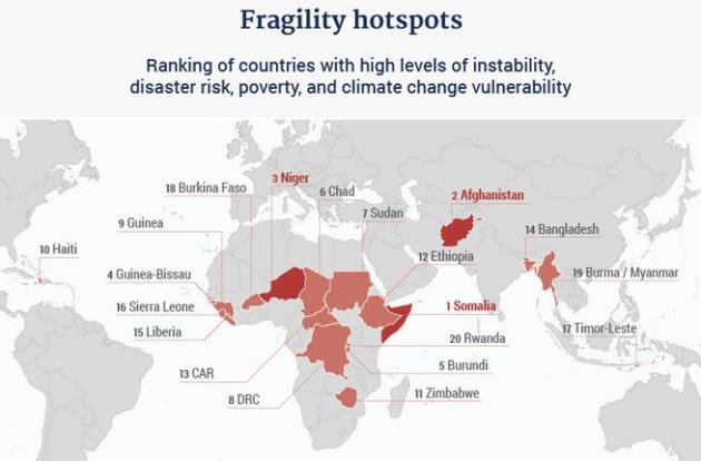
Climate Change is a Security Threat. Make It a Foreign Policy Priority. Grist has the story; here's a clip: "...
Now, a new independent report
commissioned by the G7, the forum composed of the seven wealthiest
developed countries and the E.U., argues that addressing the threat
multiplier hypothesis needs to be a top foreign policy priority. The
authors also contend that policymakers need to integrate their
approaches to climate change adaptation, international development and
resilience training, and peacebuilding. Titled “A New Climate for Peace:
Taking Action on Climate and Fragility Risks,” the report also analyzes
several climate-fragility case studies, including the Syrian case, in
order to help paint a picture of the global nature of the trends at
play. The picture isn’t pretty..." (Image: New Climate for Peace)
Global Warming "To Fuel Migration, Terrorism" AFP and
Yahoo News UK has a summary from a new study; here's an excerpt: "
Global
warming-induced food and water shortages may cause mass migration,
competition for resources and state failure, providing fertile ground
for conflict and terrorism, analysts warned Monday. In a report
entitled: "Climate Change, A Risk Assessment", a global team of
scientists, policy analysts and financial and military risk experts
painted a grim picture of mankind's future on a much warmer planet..."
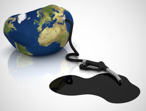
Shell U.S. Unit May Drop "Oil" From Name In Sign of Times. Because, increasingly, oil is becoming a dirty word.
Bloomberg Business has the introduction to an unlikely move: "
The
U.S. unit of Royal Dutch Shell Plc may soon drop the word “oil” from
its name in a move that would symbolize its transition to other sources
of energy, an executive said. With Shell Oil Co.’s parent focusing more
on natural gas and looking at other energy alternatives, the oil in the
name “is a little old-fashioned, I’d say, and at one point we’ll
probably do something about that,” Marvin Odum, director of the
company’s upstream Americas business, said Thursday at the Toronto
Global Forum..." (AP Photo/Peter Dejong, File).
Fossil Fuel Industry Must "Implode" To Avoid Climate Disaster, Says Top Scientist. Here's an excerpt from a story at
The Guardian: "...
An
“induced implosion” of the fossil fuel industry must take place for
there to be any chance of avoiding dangerous global warming, according
to one of the world’s most influential climate scientists. Professor
Hans Joachim Schellnhuber, an adviser to the German government and Pope
Francis, said on Friday: “In the end it is a moral decision. Do you want
to be part of the generation that screwed up the planet for the next
1,000 years? I don’t think we should make that decision...”
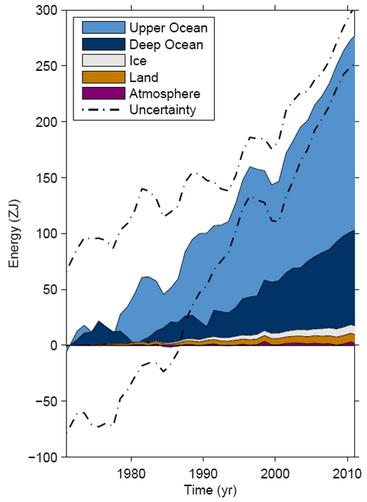
NASA Says Global Warming Hidden by Pacific and Indian Oceans.
The oceans make up an estimated 93% of Earth's energy system and that's
where the majority of excess heat has been going; here's the intro to a
story at
Tech Times: "
A
new reearch by NASA has revealed that extra heat from greenhouse gases
were trapped in the Indian and Pacific oceans in recent years and this
could likely be the cause of the so-called pause in global warming that
was observed over the past decade..."
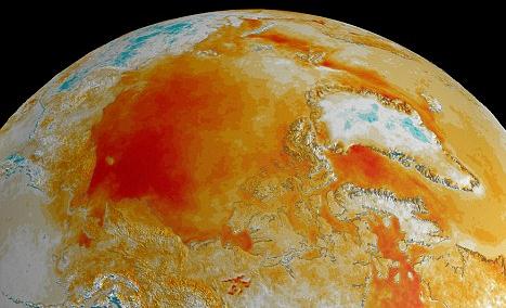
Unraveling The Relationship Between Climate Change and Health.
The New York Times reports; here's a snippet: "...
Still,
climate change is a contributing factor. Ragweed now blooms about two
to three weeks longer in the north central United States than it did a
few decades ago, extending sneezing and watery eyes further into the fall, according to research led by Lewis H. Ziska, a plant scientist at the United States Department of Agriculture. The Asian tiger mosquito, which came to the southern United States
from Japan in the 1980s, likely in a shipment of used tires, has
recently spread as far north as Connecticut, an encroachment scientists
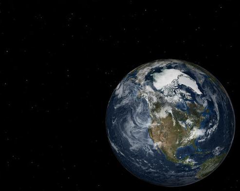
have connected to rising temperatures, said Dina Fonseca, an entomology professor at Rutgers University..." (File image above: NASA).



No comments:
Post a Comment