84 F. high in the Twin Cities Tuesday.
84 F. average high on July 14.
65 F. high on July 14, 2014.
July 14, 2003:
At least eleven tornadoes hit Minnesota. Damage was relatively light.
Baseball-sized hail is reported at Indus in Koochiching County.
July 14, 1936:
The hottest day ever in the Twin Cities with 108 degrees at the
downtown Minneapolis office. 71 people died due to the extreme heat in
one day in the Twin Cities.
July 14, 1916: Cloudburst at New Ulm dumps over seven inches of rain in seven hours.
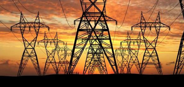
 Power Outage
We're
going to need stronger, more wind-resistant species of trees. That and
cost-effective ways to keep the lights on, no matter what Mother Nature
hurls at us.
Friends and neighbors living near Brainerd are still without power, a result of
Sunday
night's wild wind display. A developing derecho produced winds of 70-85
mph for a period of 5-10 minutes. Soil was wet from recent rains; many
of those trees didn't have a chance.
On the blog I'm including
research findings from the EIA, the Energy Information Administration.
Data shows A 10-fold increase in incidents related to extreme weather on
America's power grid since 1992. A symptom of climate change? Aging
infrastructure? Not sure - but I wish I had an emergency generator. Or
solar panels powering a big Tesla Powerwall battery.
We're going to need to build resilience into everything we do going forward.
A stray thundershower may bubble up this afternoon with more widespread T-storms
Thursday; a few models are printing out over 1 inch of rain. We may hit mid-90s
Saturday before strong to severe storms cool us off
Saturday night; a breath of fresh air
Sunday before a warming trend next week.
Welcome to prime-time summertime!
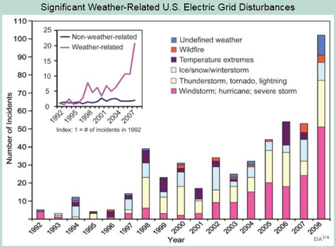
Troubling Severe Weather Trends With The Grid. A 10-fold increase in incidents on the USA power grid triggered by extreme weather - according to the
Energy Information Administration. Here's an excerpt from a summary at The U.S. Global Change Research Program: "
The
number of incidents caused by extreme weather has increased tenfold
since 1992. The portion of all events that are caused by weather-related
phenomena has more than tripled from about 20 percent in the early
1990s to about 65 percent in recent years. The weather-related events
are more severe, with an average of about 180,000 customers affected per
event compared to about 100,000 for non-weather-related events (and
50,000 excluding the massive blackout of August 2003). The data
shown include disturbances that occurred on the nation’s large-scale
“bulk” electric transmission systems. Most outages occur in local
distribution networks and are not included in the graph. Although the
figure does not demonstrate a cause-effect relationship between climate
change and grid disruption, it does suggest that weather and climate
extremes often have important effects on grid disruptions. We do know
that more frequent weather and climate extremes are likely in the
future, which poses unknown new risks for the electric grid." Image Reference above: EIA"
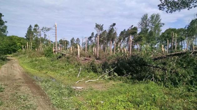
Storm Damage Closes Pillsbury State Forest.
Good grief - check out the damage caused by 70-85 mph winds for a
period of 5-10 minutes as a derecho formed over central Minnesota Sunday
evening. Here's an excerpt from the
Minnesota DNR: "
All
roads and recreational facilities in the Pillsbury State Forest, which
is located just west of Brainerd, have been closed until further notice
following a heavy rain and windstorm on Sunday, July 12, according to
the Minnesota Department of Natural Resources Forestry Division.
Uprooted and downed trees have caused all forest roads and trails to be
impassable, and all campgrouns are inaccessible..."
Central Minnesota Cleaning Up After Severe Storms Sweep Through. Here's an excerpt of an update from
The Duluth News Tribune: "...
Bray
said until downed lines are secured, the highway department must be
somewhat limited in its response due to safety concerns. There are
numerous roads within the county that remain impassable. Power
companies, fire departments, and the Crow Wing County Highway Department
along with city public works are working diligently to restore power
and open roads. Individuals with cabins in Crow Wing County are advised
to be aware of downed power lines when returning to the area to check on
property. Please contact your power company if downed power lines are
located..."
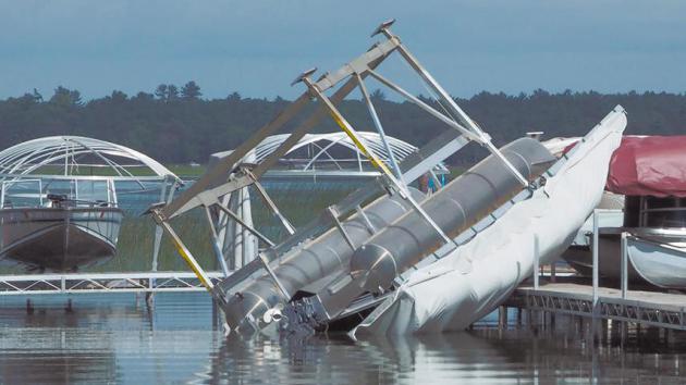
Photo credit above: "
A pontoon, still
attached to its boat lift, rests upside down after being flipped over
during Sunday's storm on North Long Lake north of Brainerd." Photo by Tim Bogenschutz/Brainerd Dispatch.
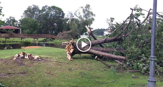
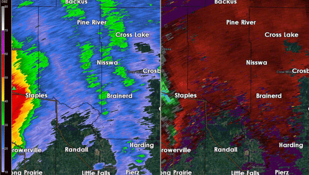 Sunday Night's Brewing Derecho
.
Thanks to Aeris Weather meteorologist Todd Nelson for capturing
reflectivity (upper left) and velocity fields (upper right) from the
Duluth National Weather Service Doppler. The rotating supercell
thunderstorms that swept east from Fergus Falls to Wadena and Brainerd
whipped up 70-80 mph winds in a fairly wide swath between Brainerd and
Nisswa, cutting down hundreds, possibly thousands of trees.
Widespread
Damage. I couldn't believe the number of trees down when I drove from
Nisswa to Brainerd Monday morning. The Star Tribune has more
perspective, including a
video of damage to Madden's Resort on Gull Lake.
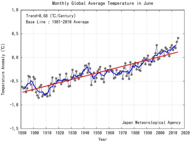
Globally: Warmest June Since 1891. Here's an excerpt from JMA, the
Japanese Meteorological Agency: "
The
monthly anomaly of the global average surface temperature in June 2015
(i.e. the average of the near-surface air temperature over land and the
SST) was +0.41°C above the 1981-2010 average (+0.76°C above the 20th
century average), and was the warmest since 1891. On a longer time
scale, global average surface temperatures have risen at a rate of about
0.68°C per century..."
 Ask Paul
. Weather-related questions, comments and threats.
PaulAny
idea what NOAA was doing w a P3 Orion flying in / around the Sun night
derecho at 5300 feet? (See the path from Flight Tracker -- FT --
below...) Looks to have departed Salinas KS around 5pm and got to MN in time for the "fireworks"... Does NOAA do this often? What data is collected? Must have been an interesting ride for the crew. These guys looked to be riding around inside the thing for a while. Meantime
MSP late night flights were in scramble mode trying to dodge the mess
(will send a couple screenshots from FT if you're interested...)Enjoy your blog. Lots. Thanks. Tim MorinShorewood
Great
question Tim. I confirmed with Dan Luna, MIC (Meteorologist in Charge)
of the Twin Cities office of the National Weather Service. Here is his
response:
Hi Paul,
This is the Plains Elevated
Convection at Night (PECAN) project. We do not know in advance that they
will be in our area, and I believe they are coming further north to get
data since the season is somewhat benign in the plains. For more
information see:
http://www.nssl.noaa.gov/projects/pecan/
* more details on the P3 Orion Hurricane Hunter aircraft in the Upper Midwest at
wearegreenbay.com.
Derecho?
It may be a close call whether Sunday night - Monday's storm fits the
definition of a derecho. Did it last long enough, traveling far enough?
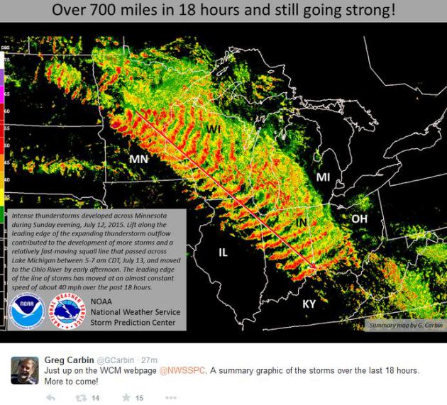
Greg Carbin at NOAA's SPC, the Storm Prediction Center, shows a
composite mosaic of the boomerang-shaped swirl of severe storms racing
southeward from Brainerd and the Twin Cities to Madison, Chicago,
Indianapolis, reaching Louisville by middday Monday. Amazing.
* Yes, it went 240 miles, and then some. According to NOAA SPC it would appear that Sunday night's storm
fits the definition of a derecho.
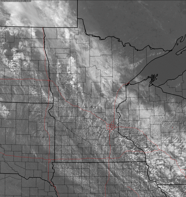
Another Day - Another Round of Storms.
Although instability wasn't as severe yesterday there was enough cold
air aloft high above the Red River Valley for more garden-variety
thundershowers to sprout. Tuesday afternoon visible loop: NOAA and
AerisWeather.
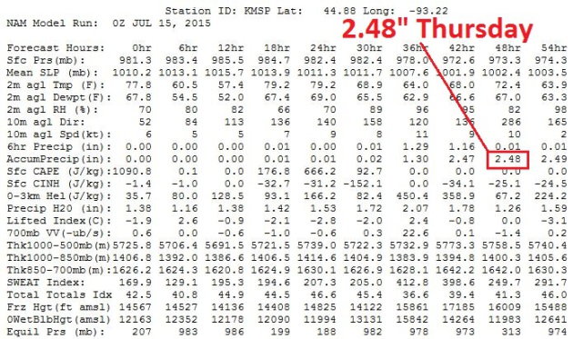
Flash Flood Potential Thursday.
The 00z NAM run prints out nearly 2.5" of rain tomorrow, with the
heaviest rains falling during the morning hours. That's consistent with
earlier runs of both the NAM and GFS. With all the construction and the
metro already in gridlock on a dry, sunny day just getting around
tomorrow could be even more painful.
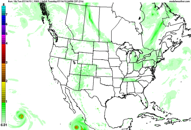
Extra-Soggy Thursday.
NOAA's NAM model prints out some 1-2" rainfall amounts from southwest
and central into northern Minnesota Thursday. It's impossible to pinpint
which counties will see the heaviest rain, but odds are you won't be
watering your yard (or field) anytime soon. Source: AerisWeather.
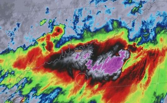
Massive El Nino Growing, Say Models.
Yes, it may be an interesting winter season, especially for California.
Historic drought to historic flooding in the meteorological blink of an
eye? We'll see, but the warm phase in the Pacific looks more impressive
with each passing week. Here's the intro to a story at
USA TODAY: "
There is growing evidence California could see an even stronger
El Niño event this winter than the 1997 one that caused massive
flooding across Northern California. Stunning images from Japan's
Himawari 8 Weather Satellite, just activated Tuesday, show what could
become a historic El Niño in full bloom. "Almost all models are showing
consistency that we're seeing a stronger and stronger tendency for that
to hold in place through the winter season. It could rival that of
1997," News10-KXTV Chief Meteorologist Monica Woods said..."
Image credit: "
The Himawari-8 Weather Satellite in Japan shows a possible historic El Nino in full bloom on Wednesday, July 8, 2015." (Photo: Himawari-8 Weather Satellite Image).
Hurricane Forecasts Get Better, Give More Warning Thanks To Big Data. Here's an excerpt of a story at Forbes: "...The stakes are high. More than 400 people died in the United States alone in 2013 in weather-related catastrophes. Extreme weather caused more than $125 billion in damages worldwide in 2013. In the U.S., damage to crops and property cost $13 billion.
In years with historic disasters, those numbers can rise significantly.
In 2005, the year of Hurricane Katrina, 1,451 people lost their lives
to extreme weather, and property damage topped $100 billion in the
U.S., according to the National Weather Service. “The ability to
collect, manipulate and analyze all sorts of big data can help the
government collaborate across agencies to better correlate weather
predictions and their effects on America’s economy,” said CenturyLink
Government Senior Vice President and General Manager Tim Meehan..."
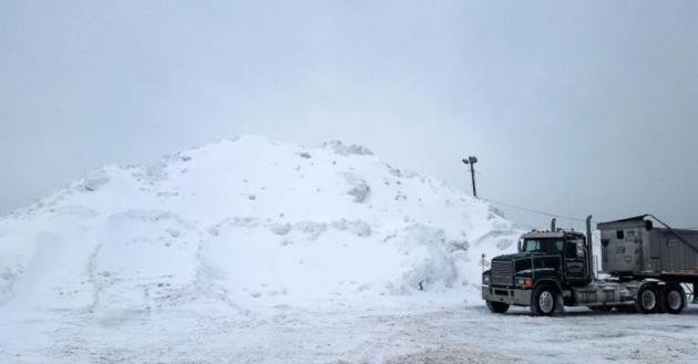
$8 Billion In Losses First Half of 2015 for North America. Here's an excerpt of a press release from Munich Re and Yahoo Finance: "In
North America, natural catastrophes in the first half of the year
caused overall losses of approximately US$ 12bn, of which insurers bore
US$ 8bn. “The costliest global natural catastrophe for the insurance
industry in the first half of the year was a series of exceptionally
cold and snowy winter storms that struck the Northeastern US and Canada
at the end of February, often leading to widespread power outages.
Boston, alone, received almost ten feet of snow over the winter months –
an absolute record,” said Tony Kuczinski, President and CEO of Munich
Reinsurance America, Inc..."
File photo above:
ABC News.
"Here Comes The Sun". Does Pop Music Have a "Rhythm of the Rain?"
Considering weather is the pond in which we live I'm not surprised our
artwork (including music) reflects a fascination with the sky draped
overhead. Here's the intro to an interesting story at
ScienceDaily: "
Weather
is frequently portrayed in popular music, with a new scientific study
finding over 750 popular music songs referring to weather, the most
common being sun and rain, and blizzards being the least common. The
study also found many song writers were inspired by weather events. The
study, led by the University of Southampton, together with the
Universities of Oxford, Manchester, Newcastle (all part of the Tyndall
Centre for Climate Change Research) and the University of Reading
analysed the weather through lyrics, musical genre, keys and links to
specific weather events..."
Making The Cut. ProPublica takes an exhaustive look at why picking the right surgeon matters even more than you know; here's an excerpt: "...
But
a ProPublica analysis of Medicare data found that, when it comes to
elective operations, it is much more important to pick the right
surgeon. Today, we are making public the complication rates of nearly
17,000 surgeons nationwide. Patients will be able to weigh surgeons’
past performance as they make what can be a life-and-death decision.
Doctors themselves can see where they stand relative to their peers..."
Why The Apple Watch is Flopping.
I'm waiting until I can have an iOS microchip implanted directly into
my skull - I want to be able to think like Google and talk like Siri.
Here's an excerpt from
Fast Company: "
The Apple Watch, despite years of hype before it was even announced, appears to be flopping after all. It wasn’t a good sign when Apple announced shortly before the Watch release that they weren’t going to be breaking out sales numbers. Now, a new report from third-party analysts Slice Intelligence not only show that Apple Watch sales are down 90% since launch—a big deal, since it implies early adopters aren't regaling more cautious buyers with glowing word-of-mouth—but also that Fitbit is outselling Apple in the wearables space..."
Addicted To Your Phone? There's Help For That. The New York Times Sunday Magazine has the story - here's an excerpt: "...
Adam
Gazzaley, a neurologist and neuroscience professor at the University of
California, San Francisco, said, “You have a population that is
starting to say, ‘Wait, we love all this technology but there seems to
be a cost — whether it’s my relationship or my work or my safety because
I’m driving and texting....” (Animation artwork above:
Matthieu Bourel).
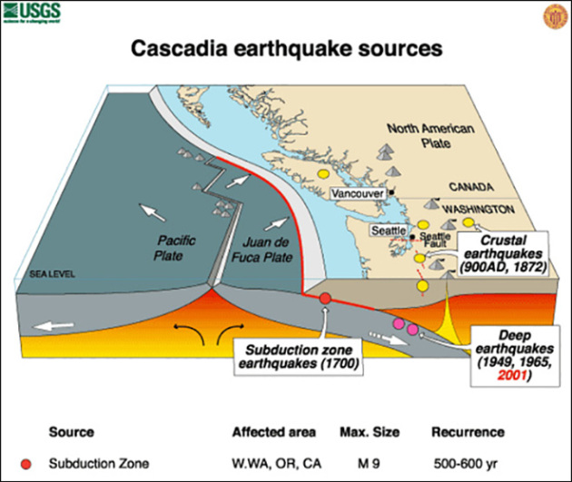
The Really Big One.
Much of California is earthquake country, but a quake along the San
Andreas fault may pale in comparison to what could happen in the Pacific
Northwest. I sent this to my oldest son, who lives in Seattle - here's
an excerpt from
The New Yorker: "...
By
the time the shaking has ceased and the tsunami has receded, the region
will be unrecognizable. Kenneth Murphy, who directs FEMA's Region X,
the division responsible for Oregon, Washington, Idaho, and Alaska,
says, “Our operating assumption is that everything west of Interstate 5
will be toast.” In the Pacific Northwest, everything west of Interstate 5
covers some hundred and forty thousand square miles, including Seattle,
Tacoma, Portland, Eugene, Salem (the capital city of Oregon), Olympia
(the capital of Washington), and some seven million people. When the
next full-margin rupture happens, that region will suffer the worst
natural disaster in the history of North America..." (Image above: USGS and
KOMO News).
Owning A Car In A City Is Shockingly Expensive - Don't Do It. Fast Company has an interesting article about car ownership for urban dwellers; here's a clip: "...Which
is to say that a car is almost useless in a city, where we have easy
access to bike lanes, public transport and—increasingly—car-sharing
schemes. But maybe you think you need a car for you out-of-town trips?
Kurt has some great advice on that:
If you’re thinking
of going carless, it’s tempting to fixate on trips that seem the most
challenging without an engine — heading to the mountains, for example.
Don’t do that. It’s discouraging. Instead, arrange all the trips you
take in a year into a pyramid, with the most frequent trips (like your
commute) at the bottom. Replace those trips first. Next, work your way
up, replacing trips that repeat weekly, like the grocery store. Already
you’ve replaced 75 percent of your car trips, which you’ll realize are
only to a few different destinations. This discovery builds confidence.
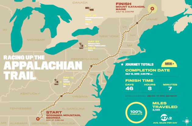
Scott Jurek Breaks Appalachian Trail Thru-Hike Record. Personally, I run when chased, but this is impressive. Here's an excerpt from
Runners World: "
At
2:03 p.m. ET on Sunday, ultramarathoner Scott Jurek crested the summit
of Mount Katahdin in Maine, becoming the fastest person to finish a
supported thru-hike on the Appalachian Trail. He completed the
2,189-mile journey in 46 days, 8 hours and 7 minutes, breaking the
previous record by just more than three hours..." (
Illustration credit: Dan Fuehrer).
TODAY: Some sun, isolated T-shower. Winds: SE 10. High: 82
WEDNESDAY NIGHT: Partly cloudy. Low: 66
THURSDAY: Heavier T-storms in the area, locally heavy rain possible. High: 77
FRIDAY: Sunnier. Bordering on hot again. Wake-up: 67. High: 87
SATURDAY: Hot sun, strong T-storms late. Wake-up: 74. High: 94
SUNDAY: Partly sunny, less humid. Dew point: 57. Wake-up: 70. High: 83
MONDAY: Mix of clouds and sun, pleasant. Wake-up: 66. High: 77
TUESDAY: Sunny and warmer. Wake-up: 68. High: 82
Climate Stories....
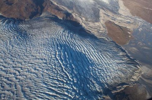
Rainfall Drives Rapid Melt, Flow Of The Greenland Ice Sheet.
Greenland has been melting faster than those "alarmist" climate
scientists have been predicting for 30 years. Probably no need to worry -
unless you live within 10-20 feet of the ocean. Here's an excerpt from
ScienceDaily: "
According
to a new study published in Nature Geoscience, the Greenland ice sheet
has been shown to accelerate in response to surface rainfall and melt
associated with late-summer and autumnal cyclonic weather events. Samuel
Doyle and an international team of colleagues led from Aberystwyth
University's Centre for Glaciology combined records of ice motion, water
pressure at the ice sheet bed, and river discharge with surface
meteorology across the western margin of the Greenland ice sheet and
captured the wide-scale effects of an unusual week of warm, wet weather
in late August and early September, 2011..."
Photo credit above: "
Crevassed glacier terminus in West Greenland." Credit: Sam Doyle.
*
University of St. Thomas professor and climate scientist John Abraham
has additional perspective on what's happening in Greenland, courtesy of
The Guardian.
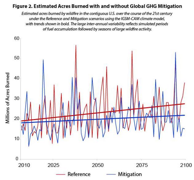
The Wild(fire) Side of Climate Change. On
the path we're on now wildfires will become even larger, more intense
and harder to knock down in the years to come. Here's an excerpt from
Earth Gauge: "...
Climate
models predict that an increase in greenhouse gas emissions will result
in even drier and warmer conditions and larger and longer-lasting
wildfires. The graphic below from the U.S. EPA’s new report, Climate Change in the United States: Benefits of Global Action,
shows the estimated acres burned with (mitigation) and without
(reference) global greenhouse gas emissions reductions over time.
According to EPA, if greenhouse gas emissions are reduced over the
course of the 21st century, the amount of U.S. forested land that can be
prevented from burning by 2100 will be two to three times the size of
California, saving $8.6 to $11 billion in wildfire response costs and
$3.4 billion in fuel management costs on conservation lands. Without
reductions over the course of the 21st century, approximately 5.3
million more acres of forested land (the size of Massachusetts) in the
U.S. is projected to burn each year at the end of the century compared
to today..."
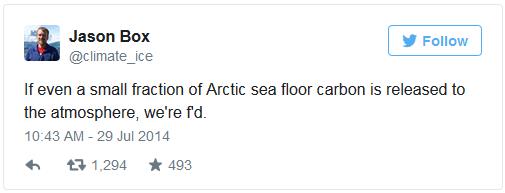
Esquire Falls Into The Despondency Trap - No, We're Not (Screwed) on Climate Change. The PG-rated article is
here,
courtesy of The Equation; here's an excerpt: "...
While Box’s statement
is conditional, saying things like “we’re f’d” has a clear implication
to most people: we are trapped and our actions won’t matter. That’s an
unhelpfully depressing sentiment. It also doesn’t have the benefit of
being true. Climate change is a major civilization-wide challenge – it’s
among the biggest risks we collectively face as a species, right
alongside nuclear war – but the extent of future climate change depends
largely on a number of human choices
we continue to make every day. Climate change doesn’t make me feel
despondent or “f’d.” It makes me feel like we need to keep working on
solutions..."
Beijing Is Finally Getting Serious About Climate Change. Foreign Policy has an interesting article; here's an excerpt that got my complete and undivided attention: "...
The
renewable energy target is a serious commitment from China. They are
adding renewable power between now and 2030 that truly dwarfs comparison
— it is the equivalent of adding the entire U.S. power grid, but only
in the form of non-fossil fuel energy. We have seen a lot of cooperation
between the United States and China, especially through the Climate
Change Working Group and EcoPartnerships between the countries — and
there will be more of these types of initiatives as we go forward...."
Media Blows The Story: Global Warming Speed-Up Is Imminent, Not An Ice Age. But an ice age is so much better for business! Here's an excerpt at
Think Progress: "...
A recent study
concluded that “any reduction in global mean near-surface temperature
due to a future decline in solar activity is likely to be a small
fraction of projected anthropogenic warming.” That’s true even for one
as big as the Maunder Minimum, which was linked to the so-called Little
Ice Age. The “Little Ice Age” is a term used to cover what appears to
have been two or three periods of modest cooling in the northern
hemisphere between 1550 and 1850. I know you are shocked, shocked to
learn that unreliable climate stories appear in U.K. tabloids, the conservative media,
and those who cite them without actually talking to leading climate
scientists. Often there is a half truth underlying such stories, but in
this case it is more like a nano-truth..."
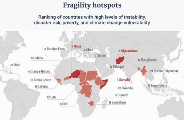
Climate Change is a Security Threat. Make It a Foreign Policy Priority. Grist has the story; here's a clip: "...
Now, a new independent report
commissioned by the G7, the forum composed of the seven wealthiest
developed countries and the E.U., argues that addressing the threat
multiplier hypothesis needs to be a top foreign policy priority. The
authors also contend that policymakers need to integrate their
approaches to climate change adaptation, international development and
resilience training, and peacebuilding. Titled “A New Climate for Peace:
Taking Action on Climate and Fragility Risks,” the report also analyzes
several climate-fragility case studies, including the Syrian case, in
order to help paint a picture of the global nature of the trends at
play. The picture isn’t pretty..." (Image: New Climate for Peace).


No comments:
Post a Comment