76 F. high in the Twin Cities Monday.
84 F. average high on July 6.
90 F. high on July 6, 2014.
2.83" rain fell yesterday at MSP International Airport, a new record for the wettest July 6.
4.5" rain soaked downtown St. Paul yesterday.
"...
In
a press release issued over the weekend, the United Nations World
Meteorological Organization warned of record-breaking temperatures and
wildfires in North America and torrential downpours and widespread
flooding in southern China. “It is notable that the time between major
heat waves (2003, 2010 and 2015) is getting shorter,” stated Omar
Baddour, who co-ordinates the WMO’s world climate data and monitoring
program..." - from an article in
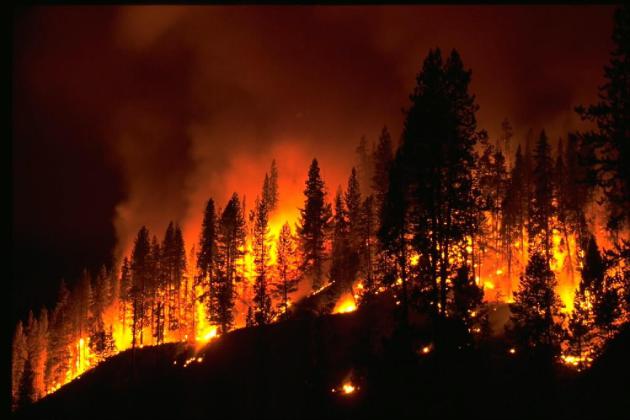
The Vancouver Sun. File photo: NOAA.
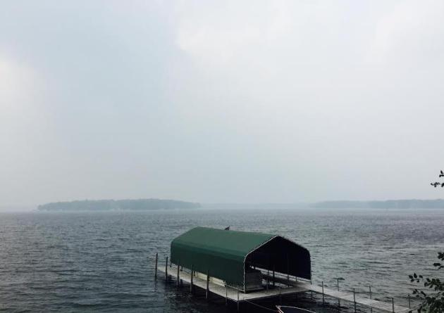
Smoke On The WaterRemind
me not to take a deep blue summer sky for granted. Last weekend was
hazy and murky. It looked like L.A. on a bad day, complete with a
cherry-red sunset. Yesterday was downright eerie with smoke dropping
visibility and creating very unhealthy conditions.
Wildfires have
charred over 2 million acres in Alaska; smoke from northern fires will
continue to drift over Minnesota in the coming days, giving the sky a
milky-white appearance at times. The Minnesota Pollution Control Agency
has issued an Air Pollution Health Alert. People with respiratory
problems up north are most likely to be impacted by the smoke plume.
Monday's
training T-storms brought 1-2 MONTH'S worth of rain to much of the
area; 3-5 inches for the immediate metro - over 7 inches near River
Falls, Wisconsin. Impressive.
I can already hear the mosquitoes talking trash.
We
cool off and dry out into midweek, but long range guidance pulls some
real summer heat north by the weekend, as highs surge well into the 80s
with a drippy dew point in the 70s by
Saturday. The approach of this free sauna sets off more scattered T-storms next weekend. What a shocker.
Historically
we see the hottest weather of the year in mid-July, but compared to the
western and southern USA Minnesota will get off easy this summer.
More smoke than heat.
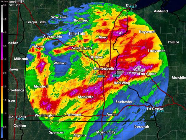
Running Out of Colors.
The derived accumulated rainfall product from the Twin Cities National
Weather Service Doppler suggests over 5" of rain near Hudson and River
Falls, which lines up with surface observations showing some 7"+ amounts
in this area. Most of the metro picked up 2-4" of rain; just about a
month's worth in many suburbs. I'll be surprised if we lapse into
drought anytime soon.
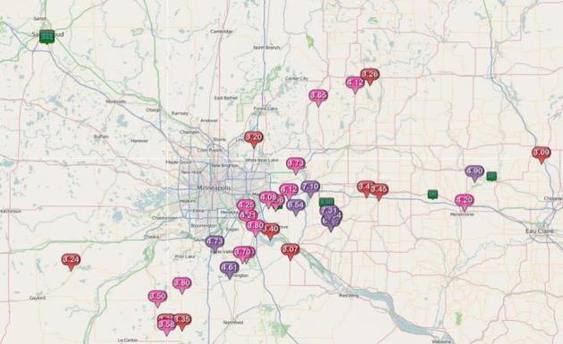
4.7" of rain soaked Burnsville; it's a
long list of communities that picked up at least 2.5" of rain yesterday.
June Monsoon.
Yesterday's deluge was the kind of rain you'd expect to see in June, in
fact 4 of the last 5 June's have been "historically wet", according ot
Dr. Mark Seeley. The aerial extent of geography that picked up 2-4" of
rain or more was impressive with Monday morning's slow frontal passage;
waves of thunderstorms tracking along the front, each one squeezing out
an inch or so of rain. Officially St. Paul picked up 4.5" of rain with
2.83" reported in MInneapolis, a new rainfall record for July 6.
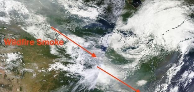
Cream of Wheat Sky.
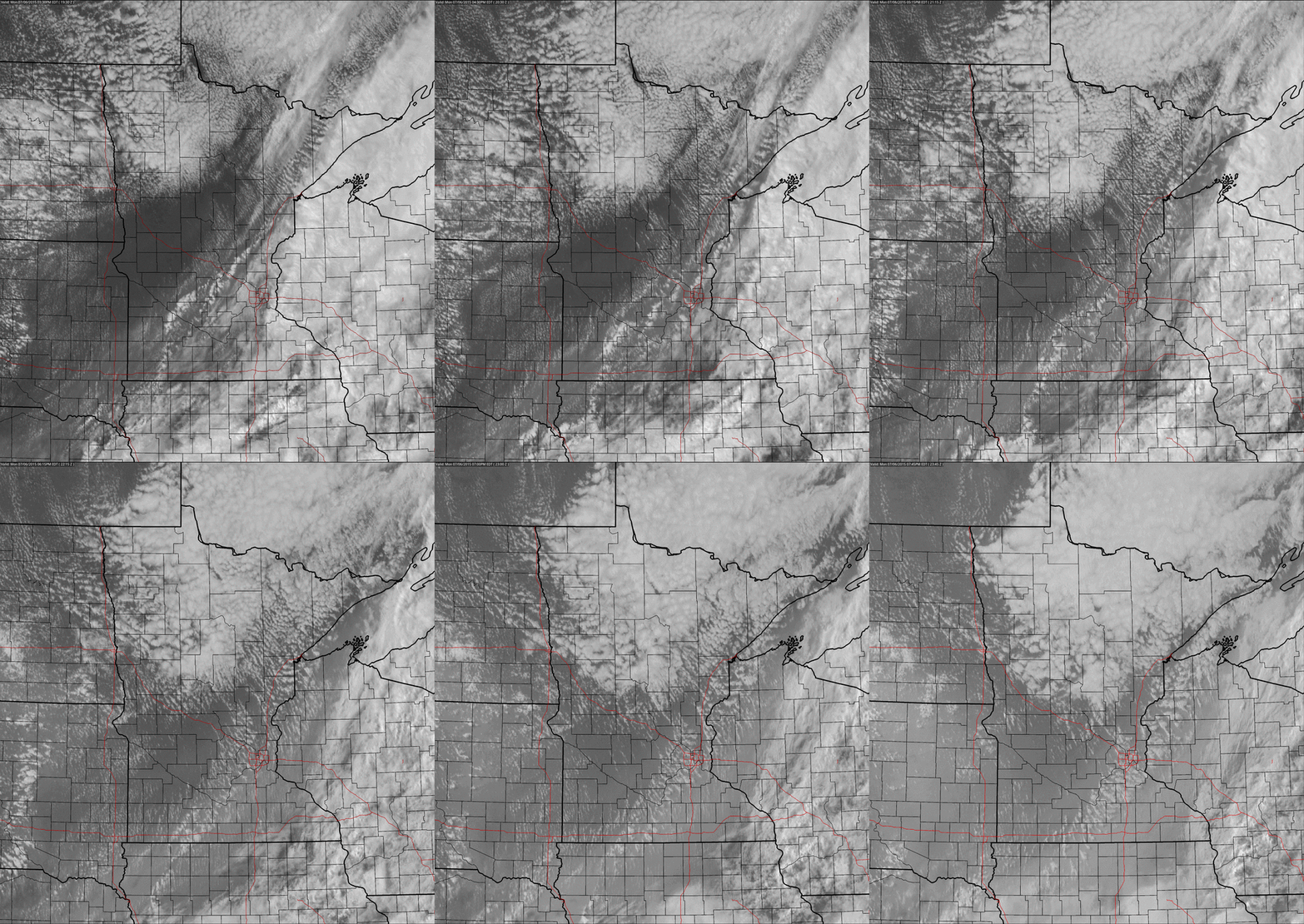
Usually skies clear and visibilities improve behind a cool frontal
passage. Usually. Strong subsidence (sinking motion) behind Monday's
cooler front helped to pull smoke 3-6 miles above the ground down to the
surface - unusual considering the source of that smoke is many hundreds
of miles upwind from Saskatchewan into British Columbia. Look carefully
at the visible satellite loop from yesterday and you can see a white
haze lingering over eastern and southern Minnesota, aerosols suspended
in the air from a rash of fires hundreds, even thousands of miles
upwind. Source: NOAA and AerisWeather.
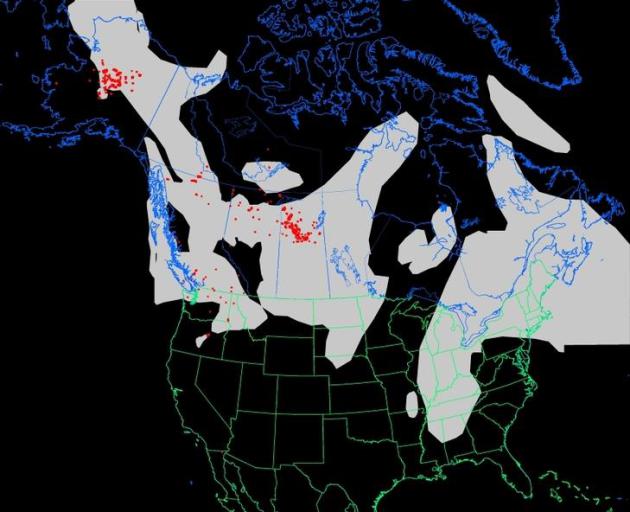
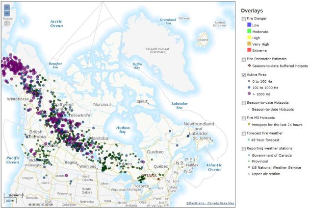
ThickSwirls of Smoke.
All those red dots above are individual fires, one of the most dense
concentrations of fire and smoke over northern Saskatchewan. With
prevailing winds blowing from the west to northwest much of that smoke
has nowhere to go but Minnesota and the Upper Midwest. At the rate we're
going we may be tracking smoke much of the summer and fall. Source:
NOAA.
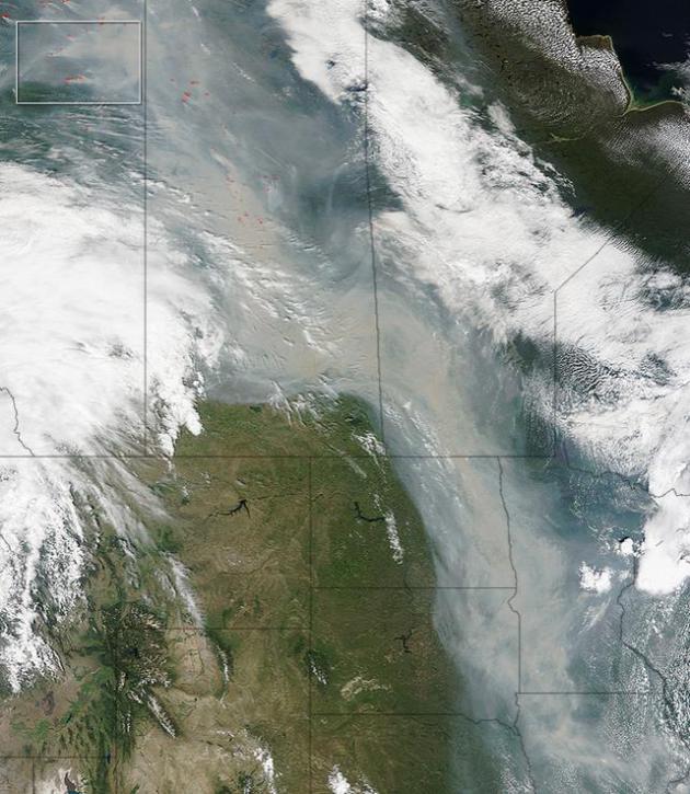
Perpetual Smoke Plume.
The smoky plume from hundreds of fires stretching from central Canada
to Alaska continues to push into the USA. This is a file image from June
29, courtesy of
NASA's Earth Observatory: "...
On June 29, 2015, the Moderate Resolution Imaging Spectroradiometer (MODIS) on NASA’s Terra satellite captured this image of smoke from hundreds of wildfires in western Canada. Actively burning areas, detected by the thermal bands
on MODIS, are outlined in red, while forests appear dark green. The
image below shows shows a closer view of smoke and fires burning in
northern Alberta near the Athabasca oil sands. While hundreds of fires are burning throughout Canada, some of the fires producing the most smoke are clustered in this area..."
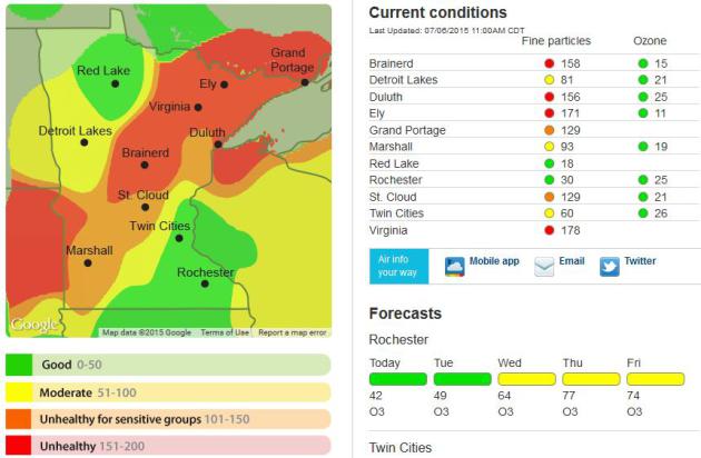
Poor Air Quality in Minnesota from Canadian Forest Fires.
Rain helped to bring some of the particulant pollution to the ground,
but there's more fire and smoke upwind so that hazy pall to the sky may
linger into much of July at the rate we're going. More on the Air
Pollution Advisory from the
Minnesota Pollution Control Agency: "
The
Minnesota Pollution Control Agency (MPCA) has issued an air pollution
health alert for the northern two-thirds of Minnesota due to smoke
blowing in from forest fires in Canada. While air quality briefly
improved following rain showers on Sunday and Monday, heavy smoke is
returning to Minnesota behind the storm system. As of 9:00 a.m. Monday,
air quality across the northern two-thirds of Minnesota had reached
unhealthy levels. Air quality is expected to remain poor throughout the
day on Monday..."
Alaskan Wildfires Char Nearly 2 Million Acres, Send Smoke to South Carolina. It's the next best thing to a (bad) Alaskan vacation. Here's an excerpt of a good explainer from Andrew Freedman at
Mashable: "
Alaska
is on track to have one of its worst wildfire seasons on record,
propelled by a combination of warming average temperatures, a
historically mild, relatively snowless winter and extremely mild spring.
So far this year, 1.88 million acres have gone up in smoke, from 617
individual fires. June 2015 beat June of 2004 in terms of both number of
fires and amount of acres burned, which means this year is now
outpacing the state's worst wildfire season ever recorded. With hundreds
of fires still burning in Alaska and in Canada, smoke has made it all
the way across the Midwest and Mid-South to the Atlantic Coast, crossing
over the Atlantic Ocean off the coast of South Carolina on Wednesday..." (Image: NASA).
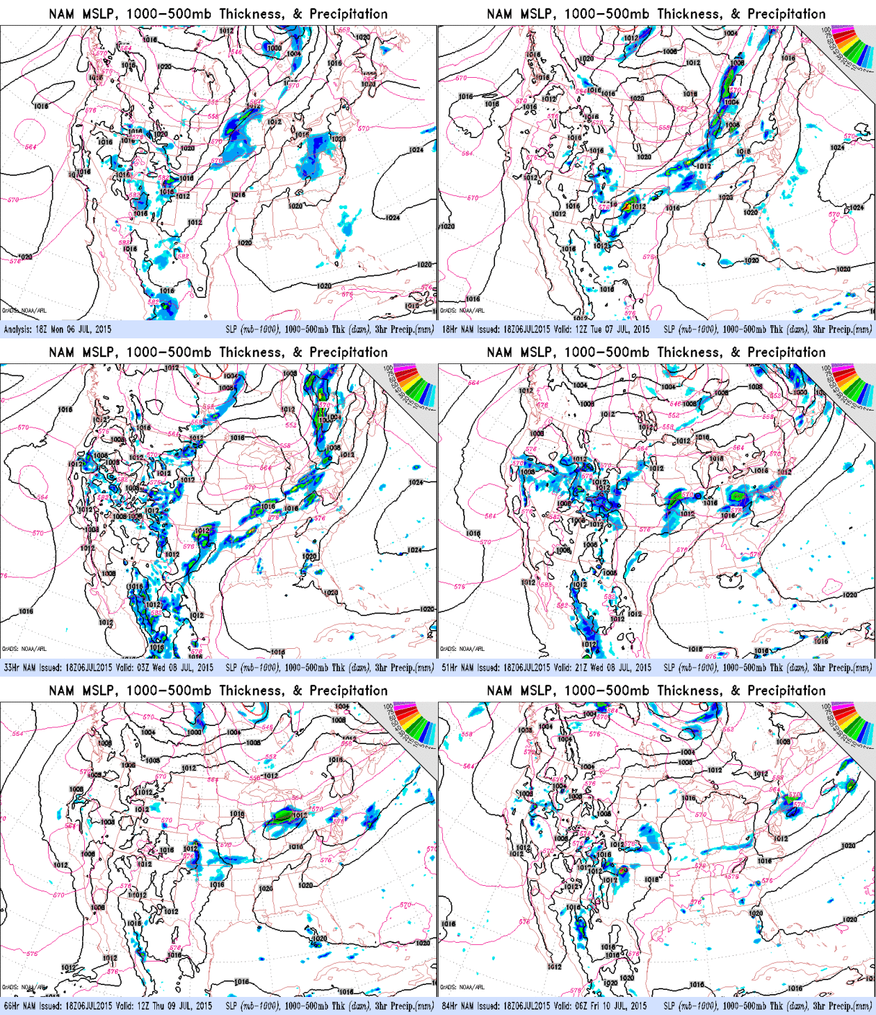
Drying Out.
We may see 4 dry days, back to back, as smoky but comfortably cool,
less humid Canadian air pushes southward. The next chance of showers and
T-storms comes late Friday and Saturday as steamy, 70-degree dew point
air approaches. Source: NOAA
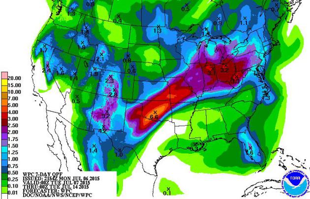
Heaviest Rains Shift South.
7-Day accumulated rainfall predictions show a swath of 3-7" from
Wichita Falls and Oklahoma City to near Kansas City and South Bend. The
heat wave tapers over the Pacific Northwest; the core of the worst heat
stay.ing south and west of Minnesota
Better Late Than Never.
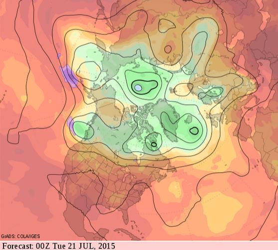
As the core of the jet stream finally lifts northward the risk of 90s
will increase as we head into late July; GFS guidance suggesting
moderately hot weather from the intermountain west to the Midwest and
Great Lakes by July 20.
An Authentic Hot Front?
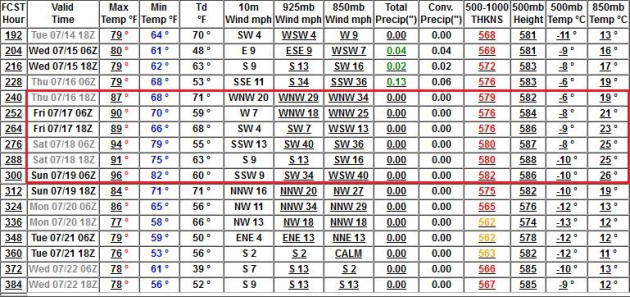
Statistically we are due for a few 90s sometime soon, and GFS guidance
brings 90s into MSP between July 16-19; by the end of next week.
How To Maximize Your Vacation Happiness.
The rush we get from material things wears off, in most cases rather
quickly. But experiences often live on in the stories we tell and
overall levels of satisfaction in our lives. Here's an excerpt of an
interesting article at
New York Magazine: "...
In terms of happiness-per-dollar-spent, vacations are the right idea in general. A lot of past research
has suggested that experiences in general provide more happiness than
material goods. That’s partly because — excited new owners of the latest
iPhone who won’t shut up notwithstanding — humans generally have more
of a tendency to talk about experiences than mere stuff. “When one buys
an experience, they seem to be buying themselves a story as well,” said Dr. Amit Kumar,
a social psychologist and postdoctoral researcher at the University of
Chicago’s Booth School of Business who studies the relationship between
money and happiness. “So one way vacations continue to provide hedonic
benefits even after they've long since passed is because they live on in
the stories we tell...”
TODAY: Sunny & comfortable. Smoke may dim the sun. Winds: N 10. Dew point: 49. High: 73
TUESDAY NIGHT: Clear and cool for early July. Low: 56
WEDNESDAY: Mix of clouds and sun (and smoke). High: 76
THURSDAY: Hazy sun, a bit warmer. Wake-up: 60. High: near 80
FRIDAY: Partly sunny, nighttime T-storms? Wake-up: 64. High: 82
SATURDAY: Sticky, scattered T-storms likely. Dew point: 70. Wake-up: 66. High: 83
SUNDAY: Hot & steamy, PM T-storms. DP: 72. Wake-up: 69. High: near 90
MONDAY: Tropical humidity, few T-storms. Wake-up: 67. High: 82
Climate Stories...
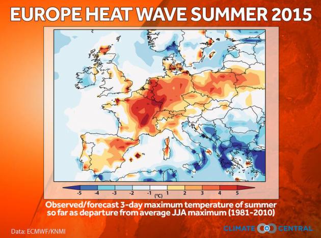
Climate Change Plays Significant Role in Europe Heat.
Climate Central
talks about the record heat gripping much of Europe and how much of it
can be attributed to a warmer temperature baseline. Here's an excerpt: "
A
team of international scientists says it is virtually certain that
climate change increased the likelihood of the ongoing heat wave
stretching across much of Europe. The risk increased by a factor of two
or more over a large part of Europe, up to more than a factor of four in
some of the hottest cities. The results are a part of the developing
field of “weather attribution”
that uses observational weather and climate data, weather forecasts and
climate models. It is widely accepted that climate change, in general,
will increase the frequency, intensity and duration of heat waves (Meehl
and Tebaldi, 2004 [1]; IPCC, 2014 [2]). The field of extreme event attribution aims to analyze individual weather events over a smaller region (Stott et al., 2004 [3]).
In the case of the ongoing heat wave in Europe, Climate Central
convened an international team of scientists from Oxford University,
KNMI, Red Cross Red Crescent Climate Centre, along with regional
partners from CNRS and MeteoSwiss in order to assess the potential role
of global warming on a specific extreme 3-day event, while the event is
happening..."
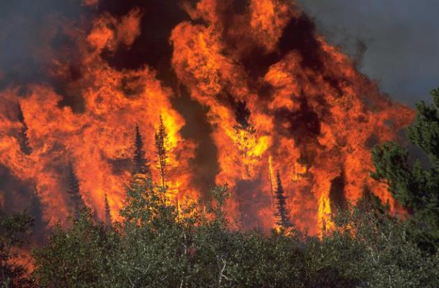
Global Warming Exacerbates British Columbia Wildfire Season, Scientist Says.
The Vancouver Sun has the story; here's an excerpt that caught my eye: "...
We’ve
predicted for some time that we will see fire seasons that last longer
and are more intense, irrespective of what is going on in the ocean
patterns.” People have thought that the impact of climate change will be
felt some time in the future, he said. “It’s not. It’s something that
is occurring now. He predicted global warning will not only increase the
length and intensity of the forest fire season, but will also affect
sockeye salmon runs, ski resorts like Whistler, which is changing to an
all-season resort, and the inaccessibility of remote areas in the north
because of an early breakup that makes transportation routes impassible..." (File photo: Capital Weather Gang).
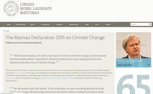
Dozens of Nobel Prize-Winning Scientists Call for Action on Climate Change. Here's an excerpt from
ThinkProgress: "
Sixty
years ago, Nobel laureates gathered on a tiny island in Western Europe
and warned the world of the dangerous effects of nuclear weapons. Last
Friday, on the same island, 36 Nobel Prize winners took up another
cause: climate change, which they said poses a “threat of comparable
magnitude” to nuclear war. “If left unchecked, our ever-increasing
demand for food, water, and energy will eventually overwhelm the Earth’s
ability to satisfy humanity’s needs, and will lead to wholesale human
tragedy,” the Nobel laureates’ declaration reads. “Already, scientists who study Earth’s climate are observing the impact of human activity...”
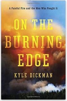
The Deadlier Scourge of Wildfires in an Age of Climate Change. Here's a snippet from a book review and story at
InsideClimate News: "...
Wildfires
in the U.S. have been growing more severe, more costly and more
frequent over the past half century. Dickman writes that mismanagement,
suppressing natural fires and allowing forests to grow dense, as well as
encroaching development have led to worse fires, with climate change providing even more fuel.
With longer periods of drought and hotter temperatures wicking moisture
from the forests, much of the West is a tinderbox. Research shows conditions will continue to worsen as the planet continues to warm..."
Episcopal Church Votes to Divest from Fossil Fuels: "This Is A Moral Issue". The Guardian reports; here the intro: "
The
leadership of the Episcopal church has voted to withdraw from fossil
fuel holdings as a means of fighting climate change, delivering an
important symbolic victory to environmental campaigners. Two weeks after
the pope’s pastoral letter on the environment, the divestment decision
by a major US Protestant denomination underscored that climate change is
increasingly seen by religious leaders as a deeply moral issue. The
measure, adopted by the governing body at a meeting in Salt Lake City,
commits the church to quit fossil fuels and re-invest in clean energy..."
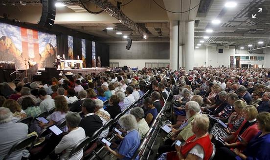
Photo credit above: "
Thousands attend a church service during the General Convention of the Episcopal Church in Salt Lake City, Utah." Photograph: Jim Urquhart/Reuters.
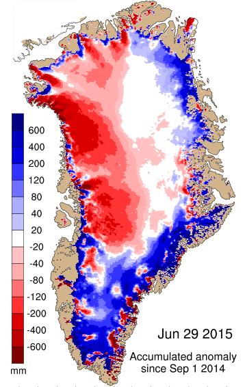
Greenland Ice Melt Accelerating. Here's a wildcard, one that climate models have actually underestimated: the rate of summer melting of Greenland ice.
Polar Portal has more information: "
The
Greenland Ice Sheet develops throughout the year with the changing
weather conditions. Precipitation contributes by increasing the mass,
whilst warmth induces melting, which makes the ice sheet diminish. The
term surface mass balance is used for the isolated gain and melting of
the surface of the ice sheet – excluding that which is lost when
glaciers calve off ice bergs and melt in contact with warm sea water.
Newly fallen snow is very bright and reflects most of the sunlight that
hits it. As the snow warms up or gets older, it becomes darker. Dark
areas absorb more energy from the sun, which leads to further warming
and melting of ice. This is called the albedo effect..."
12 Tools For Communicating Climate Change More Effectively. Here's a clip from a story at
The Guardian: "...
But
while scientists, campaigners and other communicators should never
downplay or hide the intricacies inherent in climate models, there are
better and worse ways of communicating uncertainty. A new Uncertainty Handbook
released by the University of Bristol and the Climate Outreach and
Information Network distills research finding and expert advice to set
out 12 principles of smarter communication around climate change
uncertainty. It’s intended to provide scientists, policymakers and
campaigners with the tools they need to communicate more effectively
around climate change...."



No comments:
Post a Comment