Wrapping up the Holiday Weekend
Thanks to my good friend, Rich Koivisto, for the picture below. He snapped these pictures during the fireworks celebration in Arizona Saturday night. Great picture Rich, thanks!

Soggy Start
By Todd Nelson
With all the firework displays that were going on this weekend, Mother Nature must have felt left out and decided to make a little light show herself Sunday night. Heavy pockets of rain look to continue through early Monday across parts of the region with a slow clearing trend toward the late afternoon and evening. A stout northwesterly breeze will help to chase the muggy weather south for a couple of days before returning later this week.
Interestingly, there has only been one 90 degree days this year in Minneapolis, which occurred on June 9th at 92 degrees. The 1981-2010 average suggests that we should have seen about four 90 degree (or warmer) days by now. Keep in mind that the yearly average for 90 degree days is around ten or eleven, half of which occur during the month of July.
Temperatures will take a bit of a hit early this week, with highs running nearly 5 to 10 degrees below average through Wednesday. It will come by way of little complaints with sunshine and low humidity, however, I can't say as much for what may be lurking in the extended forecast. Temps nearing 90 and higher humidity will likely start festering the complaint department
_____________________________
SUNDAY NIGHT: Storms develop (a few strong) with heavy rainfall. Low: 71. Winds: S 10-15
MONDAY: AM T-showers, slow PM clearing. High: 75. Winds: Turning NNW 10-20.
MONDAY NIGHT: Mostly clear, still breezy. Low: 56. Winds: NW 10-15
TUESDAY: Sunny, just about perfect with lower humidity. High: 74. Winds: NW 10.
WEDNESDAY: Comfortable. More PM clouds. Wake-up: 56. High: 80
THURSDAY: Warmer. Stray PM T-shower? Wake-up: 62. High: 81.
FRIDAY: Warm and sticky again. Spotty PM rumbles. Wake up: 66. High: 84.
SATURDAY: Heating up. Passing PM storm. Wake-up: 70. High: 86.
SUNDAY: Feels like summer. Wake-up: 68. High: 87.
______________________________
This Day in Weather History
July 6th
1936: A high of 104 degrees is recorded at Minneapolis.
_____________________________
Average High/Low for Minneapolis July 6th
Average High: 84F (Record: 104F set in 1936)
Average Low: 64F (Record: 49F set in 1942)
______________________________
Sunrise/Sunset Times
July 6th
Sunrise: 5:33am
Sunset: 9:01pm
_____________________________
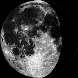
Moon Phase for July 6th at Midnight
1.6 Days Before Last Quarter
_______________________________
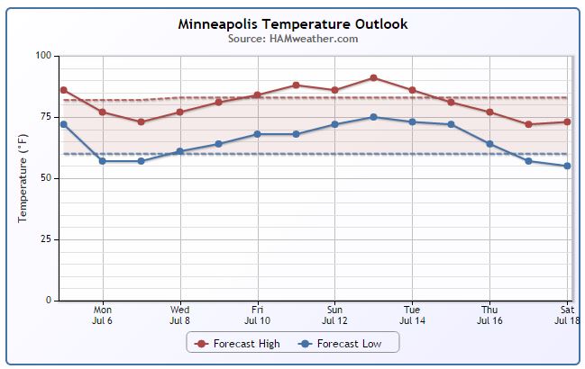
Minneapolis Temperature Trend
Temperatures take a bit of a dip early this week post storm system. It looks like we gradually warm up to average temps by the end of the week with hot and sticky conditions returning by mid month!
___________________________________
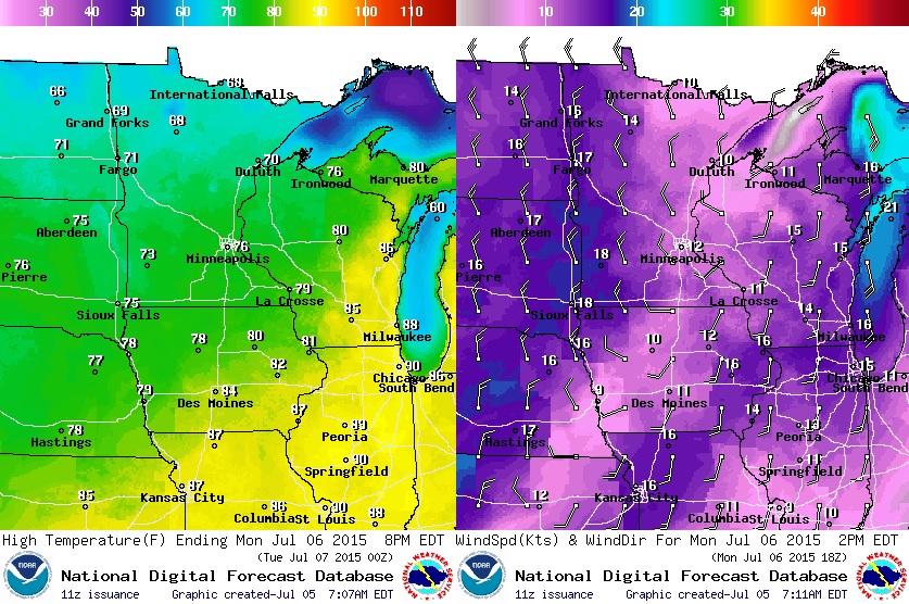
Monday Weather Outlook
Monday start on a cool and soggy note as scattered showers and storms rumble east toward the Great Lakes Region. Breezy northwest winds in the afternoon will keep highs in the northern part of the state in the 60s, while temps in the southern part of the state should drop into the 70s.
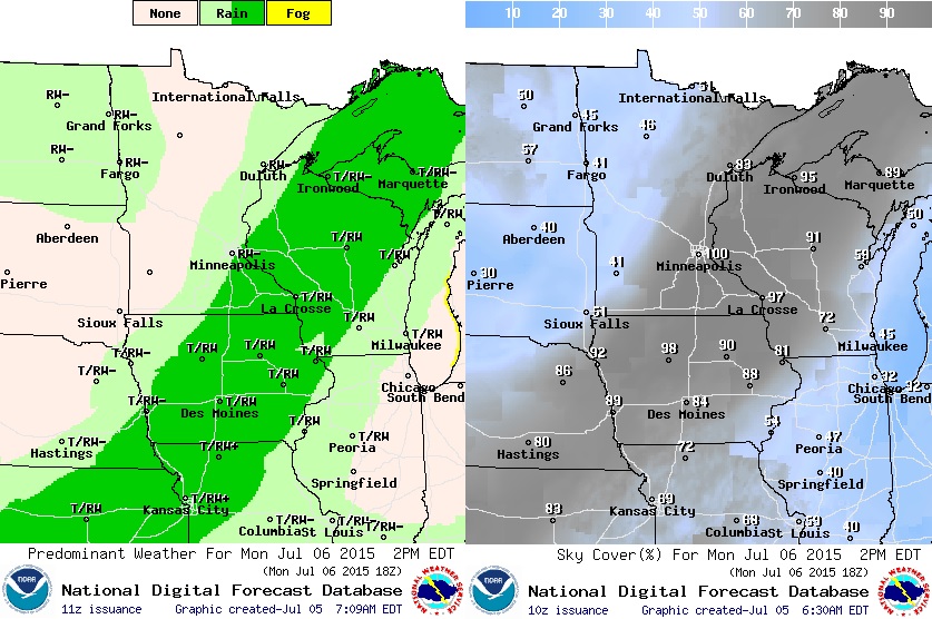
Monday Weather Outlook
The heaviest rains will be ongoing early Monday across much of the state, but as the front slides east, a slow clearing trend will take place. It appears that shower and thunderstorm activity will continue across southeastern Minnesota and Wisconsin through early/mid afternoon before things finally settle down.
____________________________________________
Rainfall Potential
Rainfall amounts in central Minnesota may be in the 1" to 2"+ range by midday Monday as the front slides through. Localized areas of flooding can't be ruled out if thunderstorm activity persists through Sunday night/early Monday.

__________________________________________
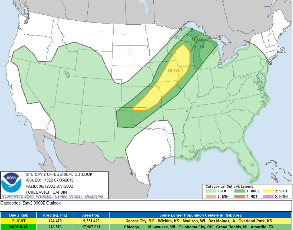
Severe Threat Sunday Night/AM Monday
Damaging winds and heavy rain look to the be the primary threat through Sunday night/early Monday as thunderstorm activity pushes through the Upper Mississippi Valley.
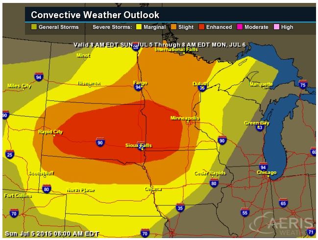
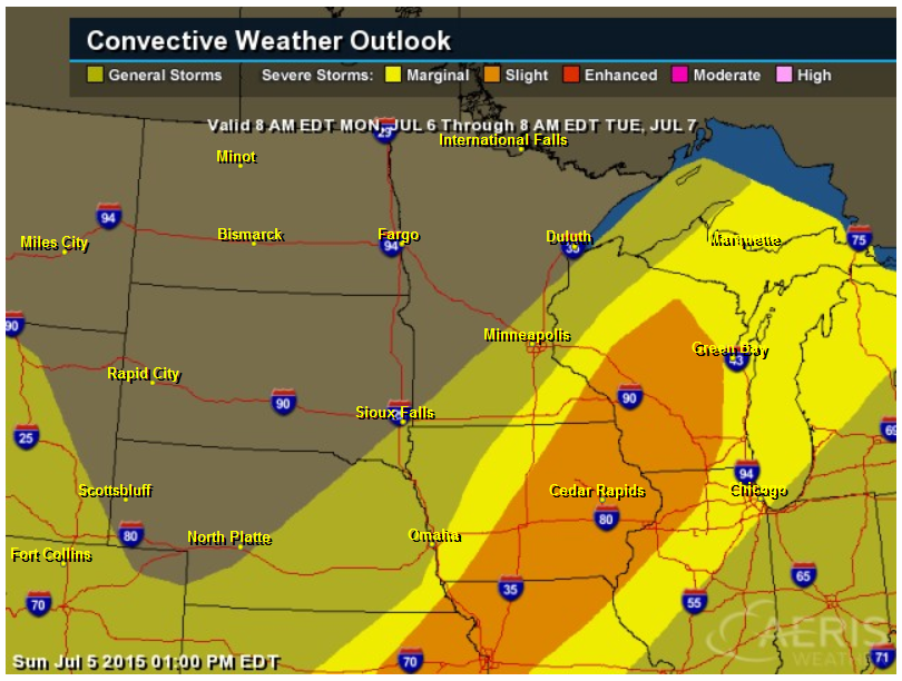
Severe Threat Monday
Thunderstorms and heavy rain will continue through early Monday, but redeveloping thunderstorms may become strong to severe once again from the Great Lakes to the Middle Mississippi Valley (potentially clipping far southeastern Minnesota by mid/late afternoon.
______________________________________
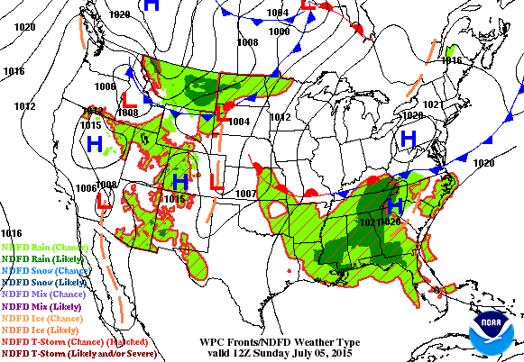
National Weather Outlook
In the loop below you can see a cool front move across the midsection of the nation through the early week timeframe. Widespread thunderstorms activity (some strong to severe) and pockets of heavy rain will be likely as the storm system sags southeast through Tuesday.
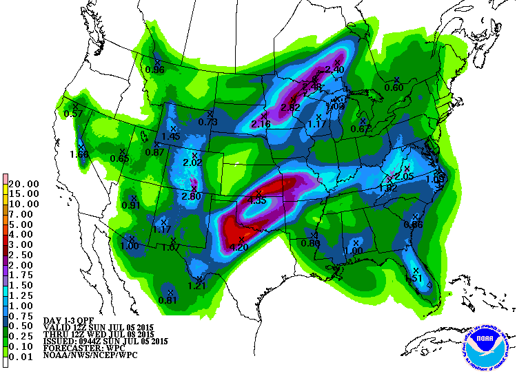
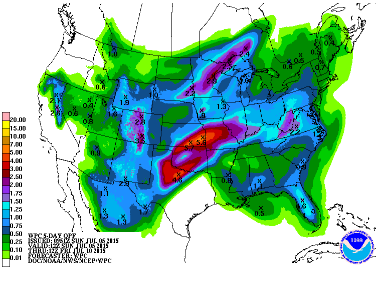
3 Day Precipitation Outlook
According to NOAA's WPC, the rainfall potential across the Upper Mississippi Valley Sunday night through early Monday could be on the order of 1" to 2"+. As the front sags south through the early week time frame, heavy rainfall amount of 2" to 4" or more may be possible over parts of the Central/Southern Plains.
5 Day Precipitation Outlook
The 5 day rainfall outlook over parts of the Central/Southern Plains suggests nearly 3" to 5" or more through the end of the week.
_____________________________________
Severe Threat Monday
...SUMMARY... AN EXTENSIVE BUT BROKEN LINE OF STRONG TO SEVERE THUNDERSTORMS CAN BE EXPECTED MONDAY AFTERNOON AND EVENING ALONG A CORRIDOR FROM SOUTHERN WISCONSIN AND NORTHERN ILLINOIS SOUTHWESTWARD INTO IOWA...NORTHERN MISSOURI...EASTERN KANSAS...AND NORTHERN OKLAHOMA. OTHER SCATTERED AFTERNOON STORMS WILL OCCUR FROM FLORIDA NORTHWARD TO THE MID-ATLANTIC...AND ACROSS THE CENTRAL AND SOUTHERN ROCKIES. ...OVERVIEW... A SERIES OF STRONG/PROGRESSIVE SHORTWAVE TROUGHS ORBITING A LARGER COMPLEX OF UPPER LOWS ACROSS NORTHERN CANADA WILL ACT TO SUBSTANTIALLY DAMPEN THE BROAD SUBTROPICAL RIDGE ACROSS THE INTERIOR WEST AND CENTRAL CONUS THIS PERIOD. THE SYNOPTIC COLD FRONT ACCOMPANYING THE LEADING IMPULSE WILL TRANSLATE EAST ACROSS THE UPPER MS VALLEY AND WRN/UPPER GREAT LAKES THROUGH MONDAY AFTERNOON AND EVENING AS STRONGER UPPER FLOW AND FORCING SPREAD EAST ALONG AND NORTH OF THE INTERNATIONAL BORDER. MODEST POST-FRONTAL SURFACE PRESSURE RISES FROM THE CANADIAN PRAIRIES TO THE NORTHERN PLAINS WILL PROMOTE A SOUTH/SOUTHEASTWARD ADVANCE OF THE COLD FRONT FROM THE CORN BELT TO THE CENTRAL/SOUTHERN PLAINS. BY LATE MONDAY AFTERNOON THE FRONT WILL BE SITUATED FROM WI/IA SOUTHWESTWARD TO THE SOUTHERN HIGH PLAINS...COINCIDENT WITH A CORRIDOR OF STRONG TO LOCALLY EXTREME INSTABILITY. ELSEWHERE....A COMPACT AND PERSISTENT MIDLEVEL LOW...CURRENTLY OVER THE SOUTHERN APPALACHIANS...WILL DEAMPLIFY AND EJECT NORTHEASTWARD TOWARD THE MID-ATLANTIC...AHEAD OF THE STRONGER HEIGHT FALLS OCCURRING OVER THE GREAT LAKES REGION. ...GREAT LAKES TO CENTRAL/SOUTHERN PLAINS... AFOREMENTIONED SHORTWAVE TROUGH WILL MAKE QUICK PROGRESS ALONG THE INTERNATIONAL BORDER WITH 500MB HEIGHT FALLS AROUND 30-60M PER 12H FORECAST TO SPREAD FROM MN ACROSS NORTHERN WI DURING THE DAY. MODEST TO STRONG SURFACE-BASED DESTABILIZATION APPEARS POSSIBLE AHEAD OF THE FRONT AND WEAK SURFACE WAVE OVER WI WHERE EFFECTIVE SHEAR ACCOMPANYING THE LARGE SCALE FORCING FOR ASCENT WILL LIKELY BE SUFFICIENT FOR STORM PERSISTENCE/ORGANIZATION. PRIMARY UNCERTAINTY WITH NORTHWARD EXTENT IS THE DEGREE TO WHICH AIRMASS CAN SUPPORT SURFACE BASED CONVECTION GIVEN POTENTIAL FOR EARLY-DAY CLOUDS/CONVECTIVE DEBRIS FROM OVERNIGHT ACTIVITY. PRESENT INDICATIONS SUGGEST BEST PROSPECTS FOR SEVERE STORMS...POSSIBLY IN THE FORM OF LINE SEGMENTS WITH EMBEDDED SUPERCELLS...WILL EVOLVE ACROSS CENTRAL AND SRN WI DURING THE LATE AFTERNOON/EARLY EVENING. THE CHANCE FOR WIND DAMAGE AND PERHAPS A TORNADO WILL PEAK IN THE 21-00 UTC TIME FRAME. SHEAR AND LARGE SCALE SUPPORT FOR ASCENT DECREASE MARKEDLY ALONG THE TRAILING COLD FRONT FROM IA SOUTHWESTWARD TO KS/NORTHERN OK. HOWEVER...LIFT ALONG THE TRAILING BOUNDARY WILL COINCIDE WITH THE DIURNAL MAXIMUM IN DESTABILIZATION ALONG THIS CORRIDOR WHERE SBCAPE IS FORECAST TO RANGE FROM 2000-4000 J/KG BY LATE AFTERNOON. GIVEN MAGNITUDE OF INSTABILITY AND BULK SHEAR VALUES IN THE RANGE OF 15-30KT...IT SEEMS REASONABLE TO EXPECT A FEW SEVERE STORMS WITH DAMAGING WINDS AND PERHAPS MARGINALLY SEVERE HAIL. WHILE WEAKEST SHEAR ALONG THE BOUNDARY WILL EXIST FROM NORTHERN MO TO KS/OK...DCAPE VALUES IN THE HOT AND DEEPLY MIXED PRE-FRONTAL AIRMASS ARE FORECAST TO EXCEED 1000 J/KG BY 21 UTC. SCATTERED DAMAGING WIND POTENTIAL SHOULD ACCOMPANY THE BROKEN CONVECTIVE LINE AS IT TRAVERSES THIS INSTABILITY AXIS BETWEEN 21-03 UTC.
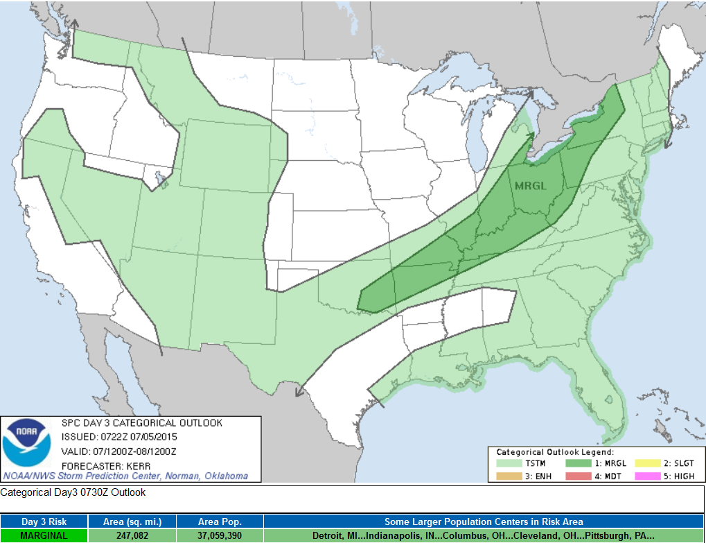
Severe Threat Tuesday
...SUMMARY... WIDELY SCATTERED STRONG TO SEVERE STORM DEVELOPMENT IS POSSIBLE TUESDAY IN CORRIDOR FROM THE LOWER GREAT LAKES REGION SOUTHWESTWARD THROUGH THE LOWER OHIO VALLEY INTO PORTIONS OF THE SOUTH CENTRAL PLAINS. ...SYNOPSIS... MID-LATITUDE WESTERLIES APPEAR LIKELY TO REMAIN BROADLY CYCLONIC EAST OF THE CANADIAN ROCKIES THROUGH MUCH OF THE REMAINDER OF CANADA...AND ADJACENT NORTHERN U.S. PLAINS THROUGH UPPER GREAT LAKES REGION...DURING THIS PERIOD. MODELS INDICATE AT LEAST A COUPLE OF SIGNIFICANT PERTURBATIONS EMBEDDED WITHIN THIS REGIME...INCLUDING ONE FORECAST TO GRADUALLY PIVOT TO THE NORTHEAST OF THE UPPER GREAT LAKES REGION. IN LOWER LATITUDES...THE EASTERN PERIPHERY OF A BROAD CLOSED LOW EMERGING FROM AN IMPULSE OF SUBTROPICAL EASTERN PACIFIC ORIGINS MAY GRADUALLY SPREAD INLAND ACROSS CALIFORNIA. DOWNSTREAM...A NARROW BELT OF MODEST WEST SOUTHWESTERLY MID-LEVEL FLOW MAY DEVELOP ON THE NORTHERN PERIPHERY OF SUPPRESSED SUBTROPICAL RIDGING /CENTERED OFF THE SOUTH ATLANTIC COAST/...FROM THE SOUTHERN PLAINS INTO THE CENTRAL APPALACHIANS. ...LOWER GREAT LAKES/OHIO VALLEY INTO THE SOUTH CENTRAL PLAINS... A COLD FRONT ASSOCIATED WITH THE MID-LATITUDE WESTERLIES...PERHAPS PRECEDED/MASKED BY CONSIDERABLE CONVECTIVE OUTFLOW...PROBABLY WILL SLOW OR STALL ACROSS PORTIONS OF THE SOUTH CENTRAL PLAINS INTO LOWER OHIO VALLEY...WHILE CONTINUING TO ADVANCE SOUTHEASTWARD ACROSS THE LOWER GREAT LAKES REGION AND UPPER OHIO VALLEY BY LATE TUESDAY NIGHT. THIS IS EXPECTED TO REMAIN GENERALLY TO THE EAST AND SOUTH OF THE STRONGER MID-LATITUDE WESTERLIES...AND BENEATH A RELATIVELY WARM MID/UPPER TROPOSPHERIC ENVIRONMENT CHARACTERIZED BY GENERALLY WEAK LAPSE RATES. EVEN WITHIN A SEASONABLY MOIST PRE-FRONTAL CORRIDOR...MIXED LAYER CAPE MAY NOT EXCEED 1000-2000 J/KG. DESPITE THESE LIMITATIONS...DESTABILIZATION AND FORCING IS EXPECTED TO BE SUFFICIENT TO SUPPORT RENEWED THUNDERSTORM ACTIVITY ALONG/AHEAD OF THE FRONT TUESDAY AFTERNOON AND EVENING. IT IS POSSIBLE THAT THIS ACTIVITY COULD BE ENHANCED BY A BELT OF LOWER/MID TROPOSPHERIC FLOW ON THE ORDER OF 30 KT OR SO...WITH HEAVY PRECIPITATION LOADING AND DOWNWARD MIXING OF THIS MOMENTUM CONTRIBUTING TO AT LEAST SOME RISK FOR POTENTIALLY DAMAGING WIND GUSTS.
_____________________________________
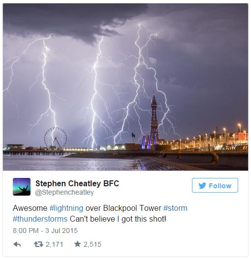
"Britain Lost Its Mind When Lightning Struck 110,000 Times"
Take a look at this story from BuzzFeed.com - I guess Mother Nature wanted in on the firework activity over Britain!
See the full story from BuzzFeed.com HERE:
___________________________________
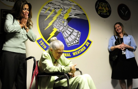
"Former WWII weather observer relives sunny days during trip to Scott Air Force Base"
Here's a neat story about a former WWII weather observer, an 87 year old woman named Cadena, who got to relive her weather observing days during a recent trip to Scott Air Force Base.
"SCOTT AIR FORCE BASE, ILL. - Norma Gene Cadena’s last wish is to relive her days as a weather observer and to see what it would be like today to do the same job. At 87, Cadena has terminal lung cancer and, through the Sisters of Saint Mary Health Hospice and Home Health Foundation “Memories that Last” program, her wish was granted to visit the 15th Operational Weather Squadron on Scott Air Force Base, June 26, 2015. Towards the end of World War II the U.S. Weather Bureau hired more than 900 women as observers and forecasters to fill the positions of men who’d been called to duty; one of those women was Cadena. Although she said she was only a “weather girl” for about a year she still remembers the responsibilities and importance of a weather observer’s job."
Read more from dvidshub.net HERE:
"Norma Cadena admires a squadron coin she received from Lt. Col. Danielle Budzko, 15th Operational Readiness Squadron commander during her visit to the squadron at Scott Air Force Base, Ill., June 26, 2015. After she received the coin she kept asking members if they wanted to see it, but wouldn’t let anyone hold it. (U.S. Air Force photo/Staff Sgt. Stephenie Wade)"
Thanks for checking in and have a great week ahead! Don't forget to follow me on Twitter @TNelsonWX
 f
f
No comments:
Post a Comment