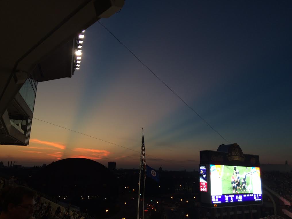
I had a fun Saturday evening with family and my 6yr. old at the Vikes game at TCF Bank Stadium. Not only was it fun to watch the Vikes beat up on the Buccs (sorry Buccs fans), but it was also neat to see the sunset. Take a look at the picture I took below just after sunset and note the two different dark streaks that seem to be shooting through the sky. These are shadows from distant thunderstorms hundreds of miles away in the eastern part of North and South Dakota. Even though the thunderstorms were 10s of thousands of feet high, the curvature of the earth meant that we couldn't see the tops of the storms from Minneapolis. However, these towering thunderstorm clouds were enough to cast shadows from the setting sun. Pretty cool, huh?!
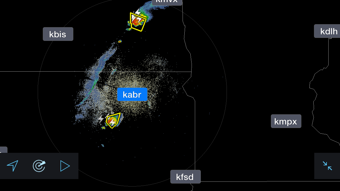
Radar Saturday Evening
This was the radar on Saturday evening around the time that I snapped the picture above. Note that the severe thunderstorms below look to mimic that of the shadows seen in the picture above.
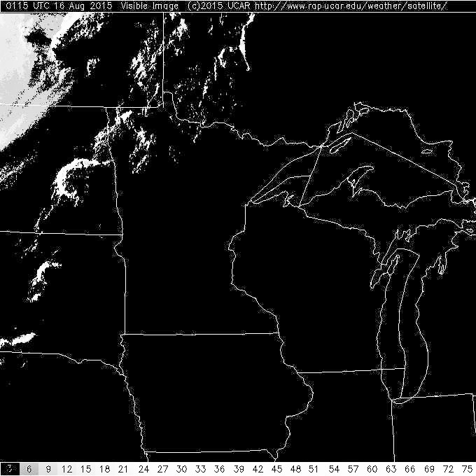
Satellite Saturday Evening
This was the satellite from Saturday evening and note the two big thunderstorms in the eastern part of North and South Dakota, these were the storms responsible for the shadows that were seen just after sunset in the Twin Cities on Saturday evening.
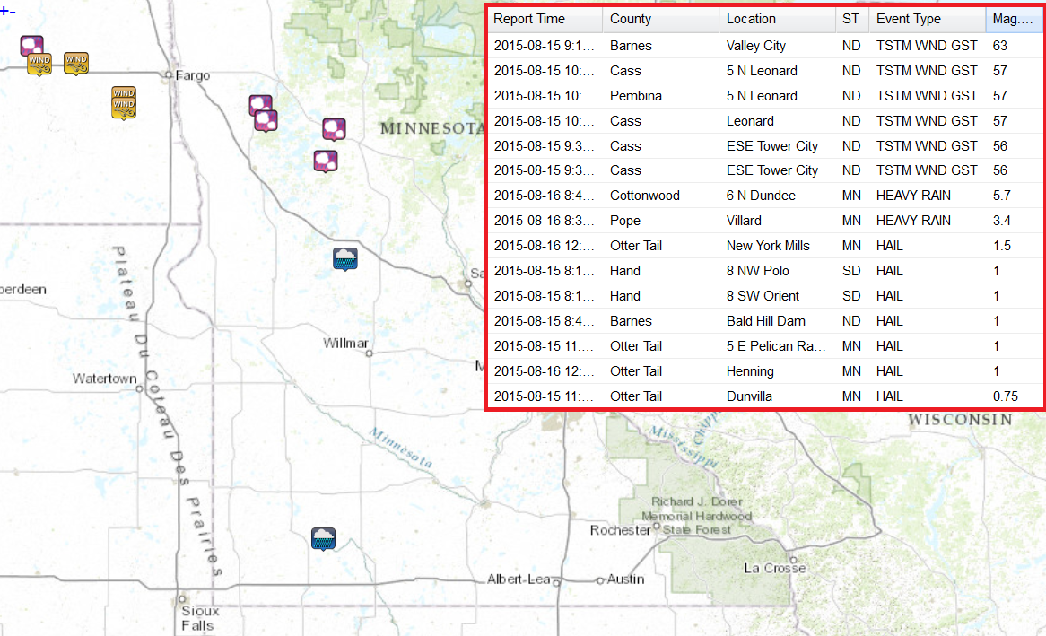
Saturday Storm Reports
A line of storms developed and slide into the western part of the state overnight Saturday with hail and heavy rain reports. Note the 5.7", 3.4" and 1.5" rainfall reports near Dundee, Villard and New York Mills
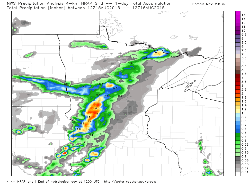
Saturday Rainfall Amounts
According to radar estimates, quite a bit of heavy rain fell fell across the western part of the state PM Saturday to AM Sunday.
_________________________________
Brief Fall Stint
By Todd Nelson
Back to back 90s on Friday and Saturday became our 3rd and 4th 90 degree or warmer days of the year in Minneapolis. If you're keeping track, this is still well below the average number, which is typically around 9 days by mid August. According to NOAA's NCDC, the 1981-2010 average for number of 90 degree days or warmer in Minneapolis is around 11, last year we only had 2! Interestingly, the most number of 90 degree or warmer days occurred in 1988 with 44 days!
There will be no 90 degree days this week as another fairly vigorous area of low pressure develops. Widely scattered showers and storms will begin pushing into the region late tonight and Tuesday. A few strong storms can't be ruled out across far southern Minnesota, but the main concern will be locally heavy rainfall, which may lead to localized areas of flooding.
The one thing you'll noticed is the much cooler than average temps with us on Tuesday and Wednesday as many struggle to get to 70 degrees! Breezy winds on Wednesday will be reminiscent of fall. Back to near average temps return by the end of the week.
Keep in mind that pollen level are on the rise, so med up! Aaaachoooo! -Todd Nelson
____________________________________
SUNDAY NIGHT: Lingering showers, possible thunder. Low: 63. Winds: W 5-10
MONDAY: Soggy start, then intervals of sun, cooler and less humid. A few lingering t-storms across far southern MN. Dew point: 60. High: 76. Winds: NNE 5-10
MONDAY NIGHT: Mostly cloudy. Showers & storms develop late. Low: 60. Winds: NNE 5
TUESDAY: Widely scattered showers and storms with locally heavy rain. High: 68. Winds: ENE 10-15
WEDNESDAY: Feels like fall. Breezy and cooler with lingering showers. Wake-up: 58. High: 68. Winds: NNW 15-25
THURSDAY: Sunny and drier. Not as windy. Wake-up: 56. High: 76
FRIDAY: Warmer. Dry start, storms overnight. Wake-up: 60. High: 80.
SATURDAY: Sticky sun, strong T-storms late. Wake-up: 64. High: 83
SUNDAY: Clearing trend. Breezy & less humid. Wake-up: 65. High: 80.
______________________________________
This Day in Weather History
August 17th
1946: A tornado kills 11 people in the Mankato area around 6:52PM. A 27 ton road grader was hurled about 100 feet. Another tornado an hour later destroys downtown Wells.
_______________________________________
Average High/Low for Minneapolis
August 17th
Average High: 81F (Record: 100F set in 1947)
Average Low: 62F (Record: 42F set in 1962)
_______________________________________
Sunrise/Sunset Times for Minneapolis
August 17th
Sunrise: 6:17am
Sunrise: 8:16pm
________________________________________
Moon Phase for August 17th at Midnight
3.7 Days Since New Moon
__________________________________________
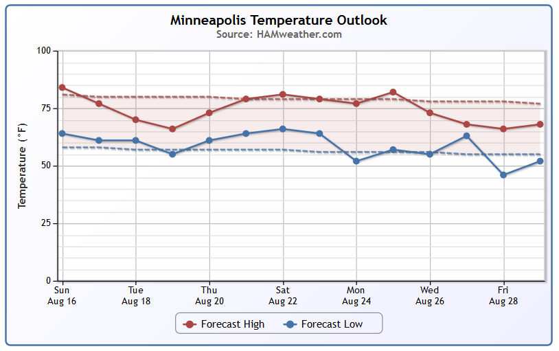
Minneapolis Temperature Trend
After posting our 3rd and 4th 90°F+ day of the year on Friday and Saturday, temperatures will take a bit of a hit this week. A fairly vigorous area of low pressure will slide through the region early this week and bring us another shot of strong storms and heavy rain. Temperatures behind the system midweek will be at their coolest with highs in the upper 60s. Wednesday will feel very much like a fall day with cool and breezy conditions. However, it doesn't take long to warm up again. Highs by the weekend get back to average and stick in the warm and somewhat humid range just prior to the start of the MN State Fair.
_____________________________________
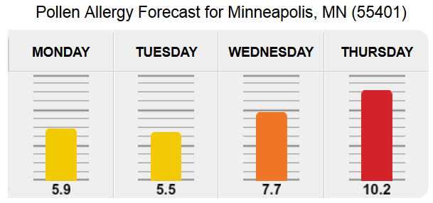
Pollen Problems
It never fails... as we approach the MN State Fair, my fall allergies begin to act up. I am not quite miserable yet, but the itchy eyes and sneezing is becoming more of a problem. According to Pollen.com, pollen levels on Monday and Tuesday shouldn't be too bad, but they really start to spike by the middle and end of the week. Thursday could be another rough day with pollen levels climbing to high levels.
See more from Pollen.com HERE:
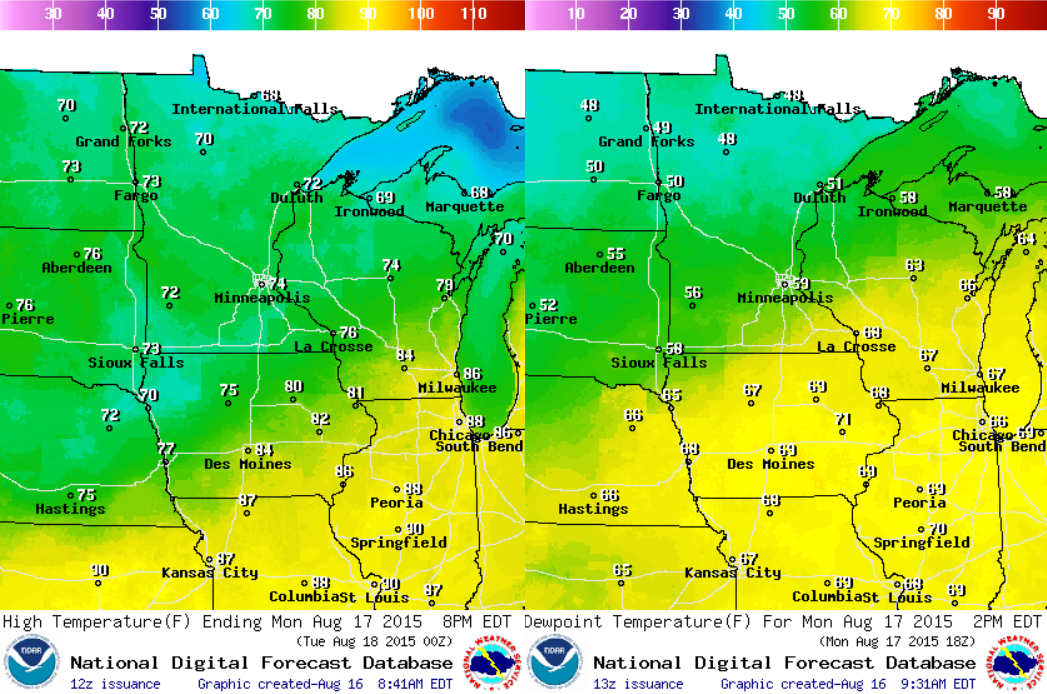
Monday Weather Outlook
Monday will feel significantly cooler than Friday and Saturday. Note the widespread high temperatures (left image) in the 60s and 70s across the state with dewpoints (right image) in the 40s and 50s. Note only will it feel cooler, but it'll feel quite a bit less humid that it has over the past days.
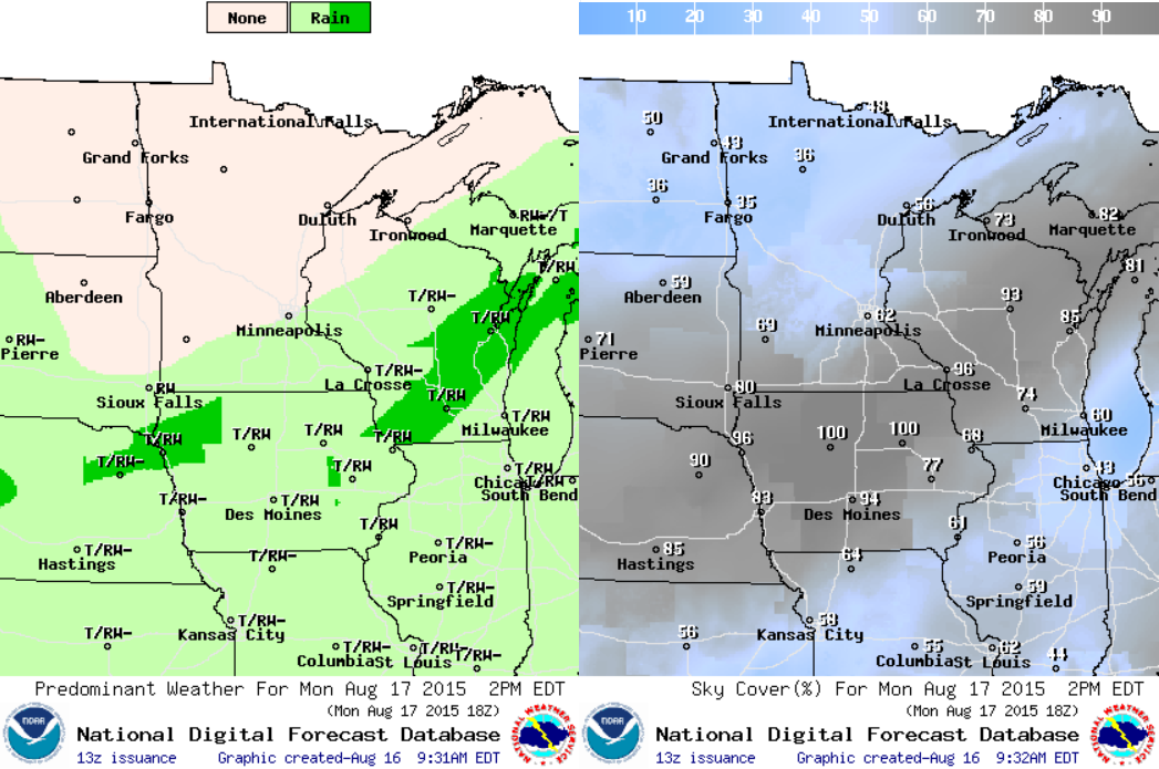
Monday Weather Outlook
Lingering showers and storms will be possible across the extreme southern part of the state into Wisconsin on Monday, but note the clearing taking place across the central and northern part of the state. Enjoy the little bit of sunshine while you can because another storm system rolls in on Tuesday with widely scattered showers and storms with the potential of heavy rainfall.
_________________________________________________
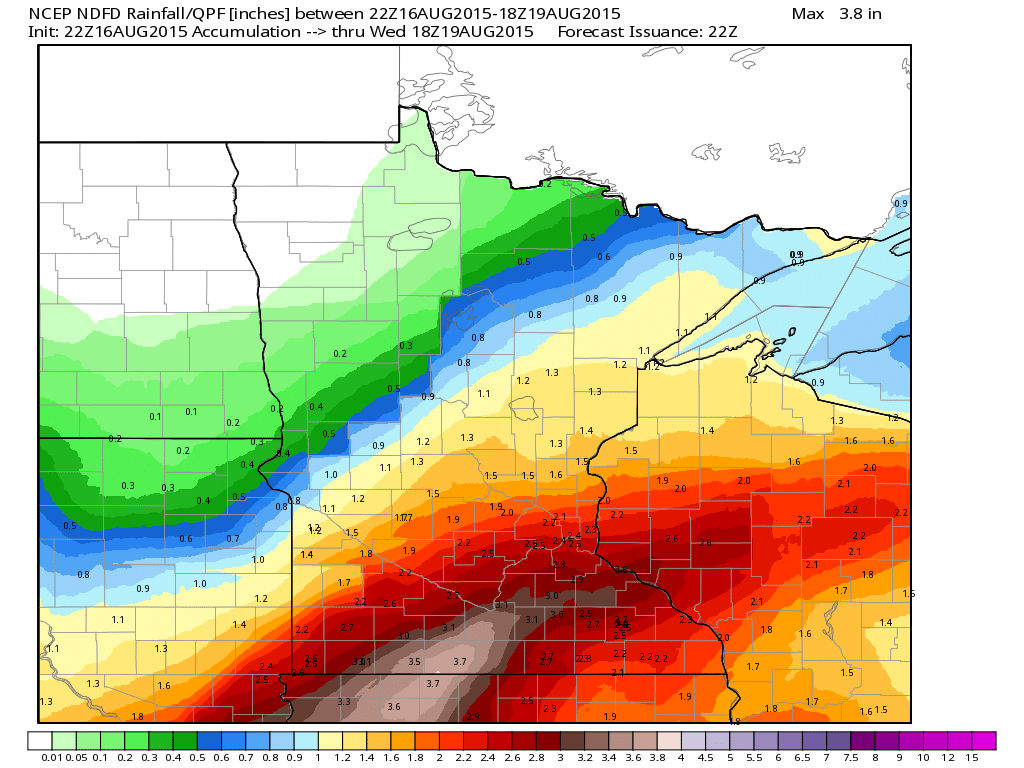
Rainfall Potential
The rainfall forecast through PM Tuesday suggests some hefty tallies across the southern part of the state with as much as 1" to 3"+ possible. Some of this locally heavy rainfall may lead to isolated flood concerns. Note that the northwestern half of the state looks to stay quite a bit drier.
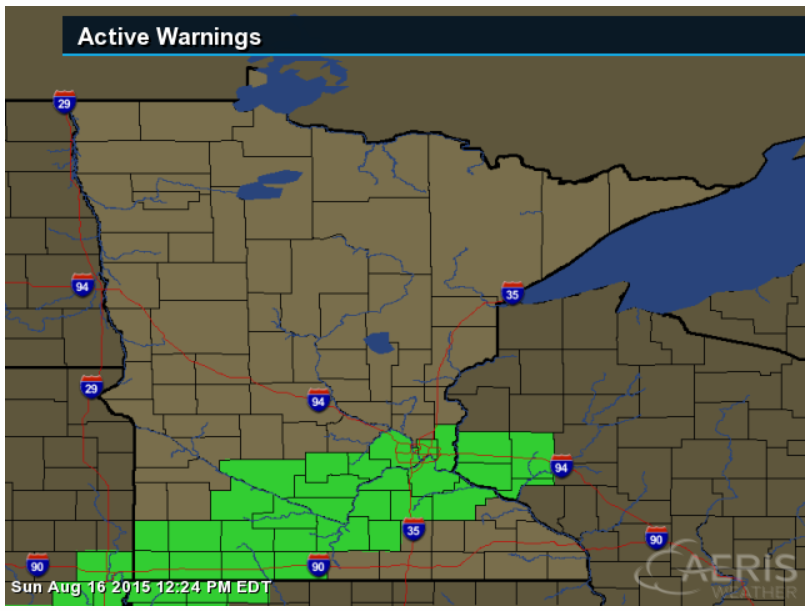
Flash Flood Watch
...TORRENTIAL RAINFALL POSSIBLE FROM LATE TODAY THROUGH MONDAY MORNING... .
A FLASH FLOOD WATCH HAS BEEN ISSUED FROM LATE THIS AFTERNOON THROUGH MONDAY MORNING FOR MUCH OF SOUTHERN MINNESOTA AND A SMALL PORTION OF WEST CENTRAL WISCONSIN. THE WATCH AREA IS ALONG AND SOUTH OF A LINE FROM OLIVIA THROUGH THE TWIN CITIES TO NEW RICHMOND AND MENOMONIE IN WESTERN WISCONSIN. A SLOW MOVING FRONTAL BOUNDARY ACROSS THE WATCH AREA WILL LIKELY LEAD TO PERIODS OF MODERATE TO HEAVY RAINFALL FROM LATE THIS AFTERNOON THROUGH EARLY MONDAY MORNING. LOCALIZED RAINFALL AMOUNTS OF 4 TO 6 INCHES ARE POSSIBLE. THIS AMOUNT OF RAIN COULD OCCUR OVER A 2 TO 3 HOUR PERIOD...RESULTING IN FLASH FLOODING.
__________________________________________
National Weather Outlook
Weather conditions will continue to sour across the Midwest during the early to midweek time frame as another area of low pressure develops. This storm system could be responsible for strong storms and localized flooding over the coming days.
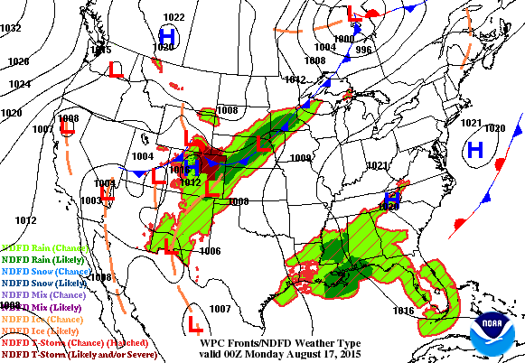
Tuesday Weather Outlook
Here's a glance at what we could be dealing with on Tuesday as another fairly vigorous area of low pressure develops and heads our way. This will not only be responsible for the potential of a few strong storms and heavy rainfall, but also, much cooler than average temperatures.
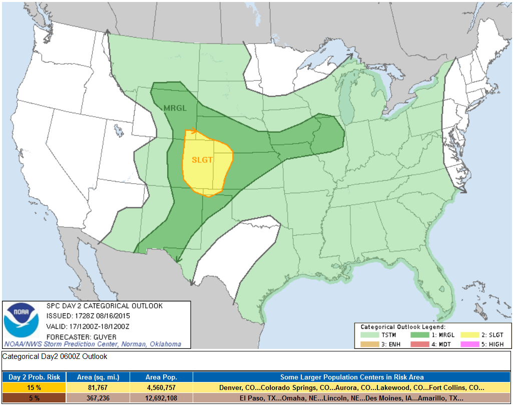
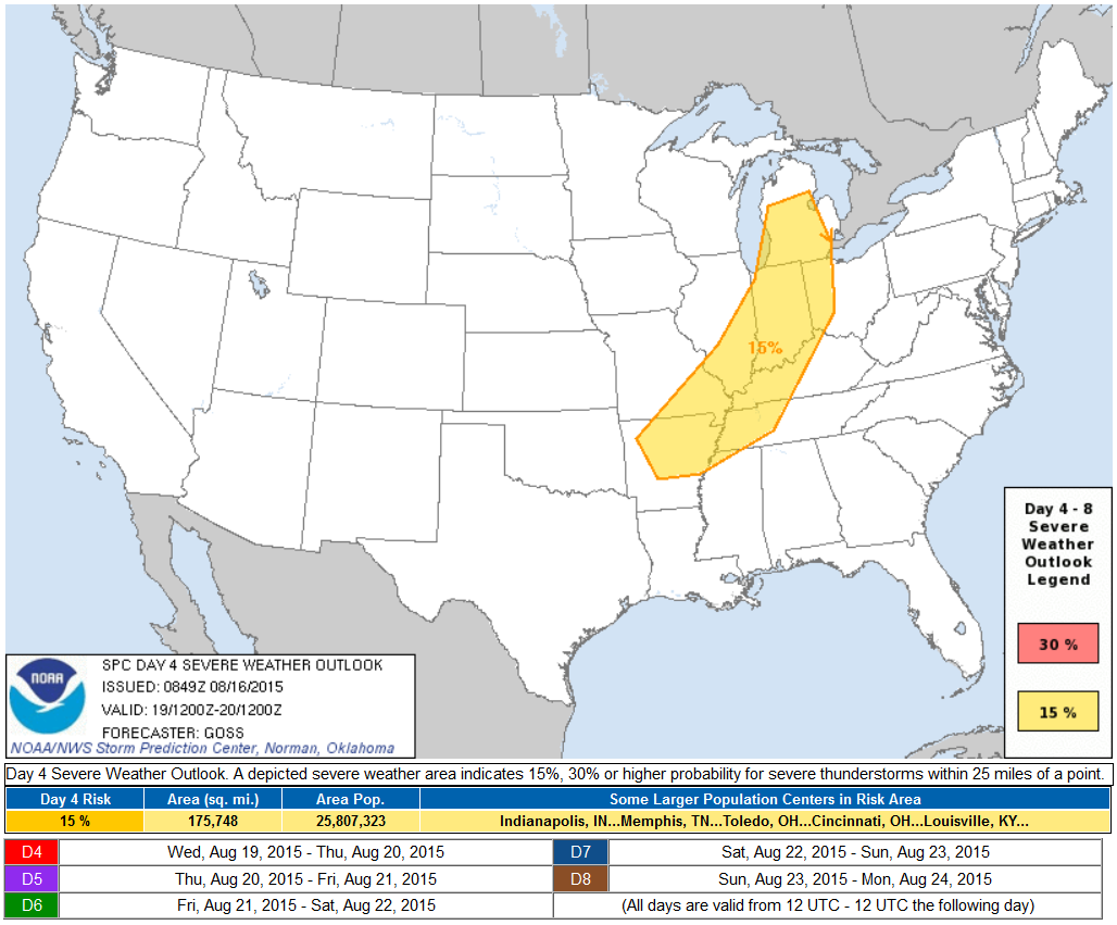
Severe Threat Monday
...SUMMARY... STRONG TO SEVERE THUNDERSTORMS WILL BE POSSIBLE MAINLY ACROSS EASTERN COLORADO AND THE ADJACENT HIGH PLAINS ON MONDAY. ...SYNOPSIS... A LARGE-SCALE PATTERN CHANGE WILL OCCUR INTO MONDAY. THIS WILL BE HIGHLIGHTED BY THE GRADUAL ABATEMENT OF THE FOUR CORNERS AREA/SOUTHWEST STATES UPPER RIDGE...WHILE LONGWAVE TROUGH AMPLIFICATION OCCURS OVER THE CANADIAN PRAIRIES AND A BROAD PART OF THE NORTH-CENTRAL CONUS. A FRONT WILL GENERALLY SETTLE SOUTH-SOUTHEASTWARD AS IT EXTENDS FROM THE CENTRAL HIGH PLAINS NORTHEASTWARD TO THE GREAT LAKES VICINITY.
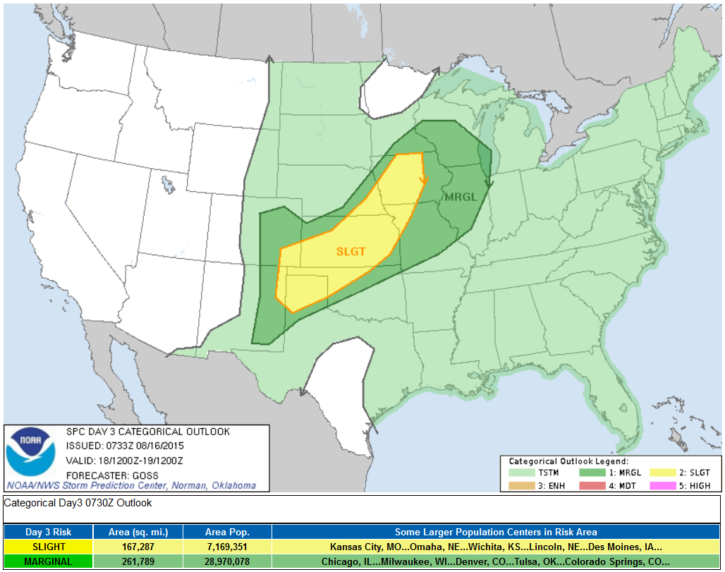
Severe Threat Tuesday
...SUMMARY... SHOWERS AND THUNDERSTORMS ARE FORECAST ACROSS MUCH OF THE EASTERN TWO-THIRDS OF THE COUNTRY TUESDAY...FROM ROUGHLY THE HIGH PLAINS EASTWARD. PRIMARY SEVERE RISK WILL LIKELY RESIDE ACROSS THE CENTRAL PART OF THE COUNTRY FROM THE MID-MISSISSIPPI VALLEY SOUTHWEST TO THE SOUTHERN HIGH PLAINS ...SYNOPSIS... A LARGE UPPER TROUGH IS FORECAST TO CONTINUE TO EVOLVE/STRENGTHEN ACROSS THE CENTRAL U.S. THIS PERIOD...WITH WEAK RIDGING EXPECTED ALONG BOTH THE W AND E COASTS. AS THE MAIN TROUGH EVOLVES...A SURFACE COLD FRONT IS FORECAST TO SHIFT SEWD ACROSS THE PLAINS...AND SHOULD EXTEND FROM THE IL VICINITY SWWD ACROSS CENTRAL AND W TX BY THE END OF THE PERIOD. THIS FRONT SHOULD FOCUS AN AXIS OF CONVECTION AND ASSOCIATED/ISOLATED SEVERE POTENTIAL THROUGH THE PERIOD.
Severe Threat Wednesday
...DISCUSSION... GIVEN THE DIFFERENCES PRESENT AMONGST THE GFS/NAM/ECMWF DAY 3 /TUE. AUG. 18/ WITH RESPECT TO EVOLUTION/ADVANCE OF A SURFACE LOW AND FRONTAL SYSTEM ACROSS THE CENTRAL CONUS...UNCERTAINTY PREVAILS EVEN INTO EARLY PORTIONS OF THE MEDIUM-RANGE PERIOD. THE GFS AND ECMWF ARE ROUGHLY CONSISTENT WITH RESPECT TO THE GENERAL LOCATION OF THE SURFACE FRONT DURING THE AFTERNOON OF DAY 4 /WED. AUG. 19/...WITHIN A ZONE FROM ROUGHLY LOWER MI SWWD TO AR. WITH STORMS LIKELY ALONG THE FRONT...AT LEAST SOME/ISOLATED SEVERE RISK IS EXPECTED AS THE LEADING FRINGE OF THE STRONGER BELT OF FLOW ALOFT EXTENDS TO THE VICINITY OF THE FRONTAL ZONE -- THUS PROVIDING SHEAR SUFFICIENT FOR AT LEAST SOME UPDRAFT ORGANIZATION.
_________________________________________
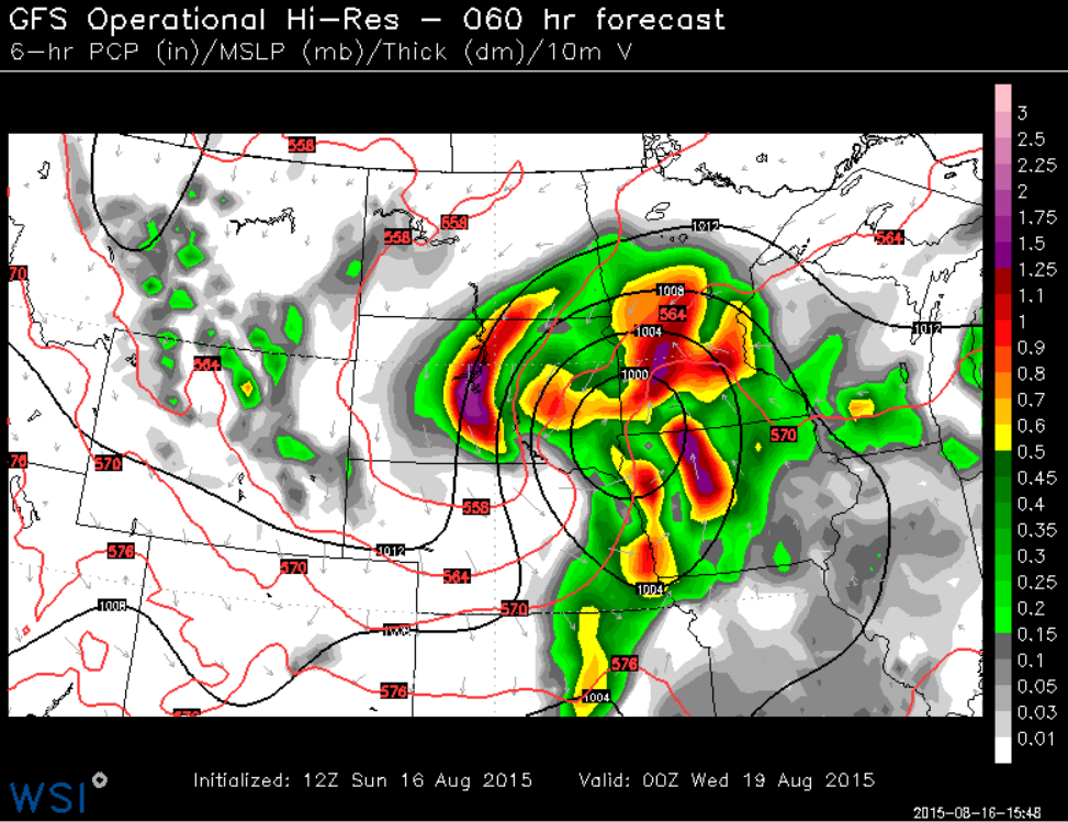
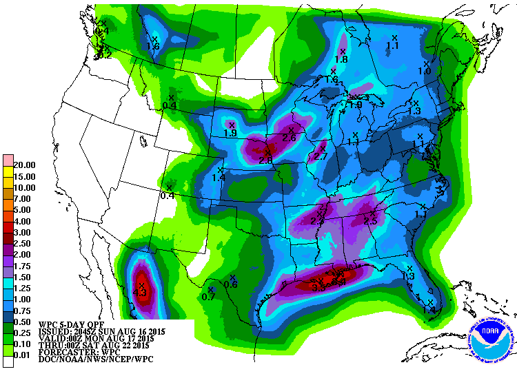
Precipitation Outlook
According to NOAA's WPC, the 5 day rainfall forecast suggests quite a bit of heavy rain across parts of the Midwest through AM Friday. Note the near 2" to 3"+ rainfall potential from Nebraska through Iowa and southeastern Minnesota into parts of Wisconsin! This could lead to localized areas of flooding.
_______________________________
Southwest Heat
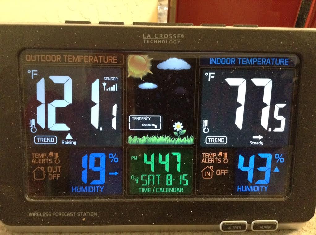
Thanks to my Dad for the picture below out of Surprize, AZ (just NW of Pheonix) who snapped this picture on Saturday afternoon. There backyard thermometer in the shade registered a staggering 121°F in the afternoon!! Pheonix, AZ had a record high on Friday at 117°F (Previous: 113°F set in 2012) and another record on Saturday at 115°F (Previous: 112°F set in 1992).
__________________________________________
Sprites Above HILDA
Hurricane HILDA in the Pacific Ocean last week made a fairly close call to the Hawaiian Islands, but tracked farther south to make any major impact. However, take a look at the neat video link below from Mauna Kea, Hawaii, which captured upper level jets and sprites thanks to HILDA.
GIGANTIC JETS ABOVE HURRICANE HILDA: Yesterday, we reported a rare apparition of sprites above Hurricane Hilda. Steve Cullen, who lives in Hawaii where the storm is heading, spotted them in video from the Canada-France-Hawaii Telescope CloudCam atop Maunakea. A closer look at the video, however, reveals that the dancing forms were not sprites. Instead, Hurricane Hilda has gigantic jets:
Read the full story from SpaceWeather.com HERE:
See the full video on VIMEO from Terry Reis HERE:
Thanks for checking in and have a great week ahead. Follow me on Twitter @TNelsonWX

No comments:
Post a Comment