Longing for Sunshine...
Can't beat a summer sunset, especially on a lake! Thanks to Stephanie Chanaka Johnson for the picture below, who snapped this over the weekend. Too bad you couldn't bottle up that weather for cool, rainy days like this Tuesday and Wednesday... Let me know if you figure out how to do that!

Wet Basement Alert
By Paul Douglas
A dear friend (Pete) sent me a frantic e-mail yesterday. "We got flooded really bad. The Aeris Pulse (app) notified me but there was nothing we could do. Everything in the basement is ruined. 4.5 inches in the rain gauge."
30 years ago climate scientists predicted that wet areas would get wetter and dry areas would get drier. Low and behold that appears to be what's unfolding on the weather map.
According to Homeland Security floods kill more Minnesotans than any other weather event; 15 people have died since 1993. And property insurance does not typically cover flood damage. Talk to your insurance representative; you may need an additional homeowners policy rider to cover the inevitable flash floods to come.
Pete, just hang out in the basement with a fresh mop. An unusually strong storm (for mid-August) sparks high winds and 1 to 2 inches of rain; more like a storm in April or October. A true soaker. Adding to the bizarre factor: temperatures won't climb out of the 60s. Was it 94F four days ago? Serious weather whiplash.
70s are the rule into next week but long-range guidance brings 90s into Minnesota by the end of August. Just in time for the Minnesota State Fair!
_________________________
MONDAY NIGHT: Cloudy with scattered showers. Low: 59. Winds: NNE 5
TUESDAY: Widely scattered showers and storms with locally heavy rain. High: 68. Winds: ENE 15-25
TUESDAY NIGHT: Showers and storms with heavy rain. Low: 58. Winds: SSE 15-25.
WEDNESDAY: Feels like fall. Breezy and cooler with lingering showers. High: 69. Winds: WNW 15-25
THURSDAY: Sunny and drier. Not as windy. Wake-up: 55. High: 76
FRIDAY:Blue sky & warmer. Wake-up: 61. High: 80.
SATURDAY: Sticky sun, strong T-storms late. Wake-up: 67. High: 82
SUNDAY: Wet start. Turning drier, better. Wake-up: 62. High: 74.
MONDAY: Plenty of sun, comfortable. Wake-up: 58. High: 79.
___________________________
This Day in Weather History
August 18th
1953: Four heifers near St. Martin were lucky; a tornado picked them up and set them back down again, unharmed.
____________________________
Average High/Low for Minneapolis
August 18th
Average High: 80F (Record: 98F set in 1976)
Average Low: 62F (Record: 41F set in 1977)
____________________________
Sunrise/Sunset Times for Minneapolis
August 18th
Sunrise: 6:18am
Sunset: 8:14pm
____________________________
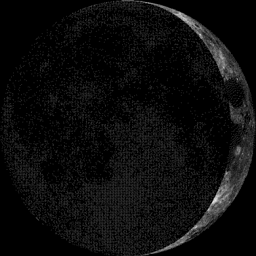
Moon Phase for August 18th at Midnight
3.5 Day Before First Quarter
______________________________
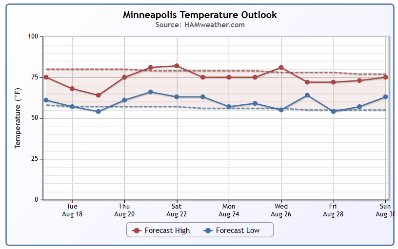
Minneapolis Temperature Trend
UNCLE! Where did summer go? Highs in the 60s Tuesday/Wednesday will be nearly 15F to 20F below average and more reminiscent of late September/early October. The good news is that we warm up quickly by the weekend with highs back to near average in the upper 70s/low 80s.
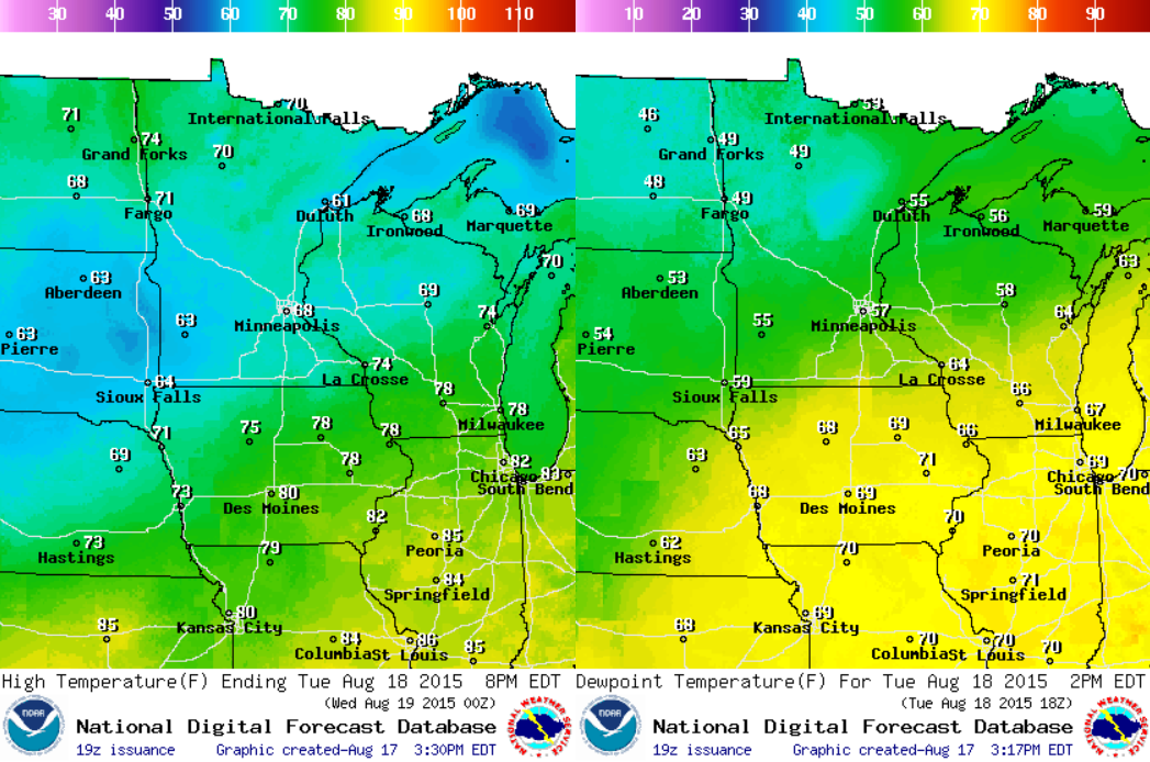
Tuesday Weather Outlook
A vigorous area of low pressure will continue to intensify over the Midwest through midweek. Widespread clouds and rain will keep temperatures quite a bit cooler than average with highs in the 60s and 70s (left) across the region. Note that dewpoints (right) range quite a bit from the 40s to the far north to the sticky 70s to the far south.
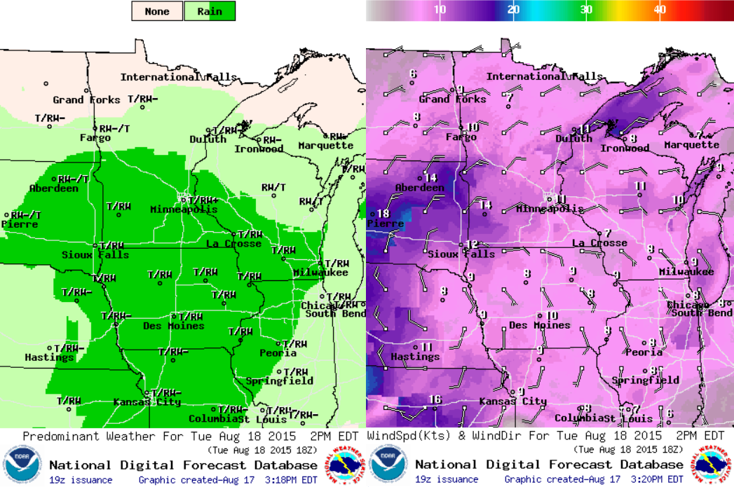
Tuesday Weather Outlook
Scattered showers and storms will move through the Upper Midwest on Tuesday with the potential of heavy rain and localized areas of flooding. The images below suggest the weather outlook (left) and winds (right) at 2pm Tuesday.
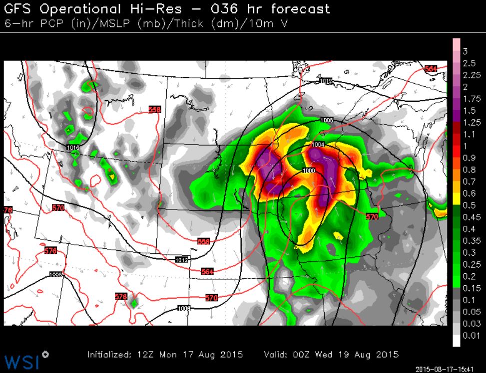
Tuesday Weather Outlook
Here's
a different look at the storm moving through the region on Tuesday.
It's actually a pretty strong storm system to be scooting through the
region in Mid August. This is something we'd see more of during the fall
months.
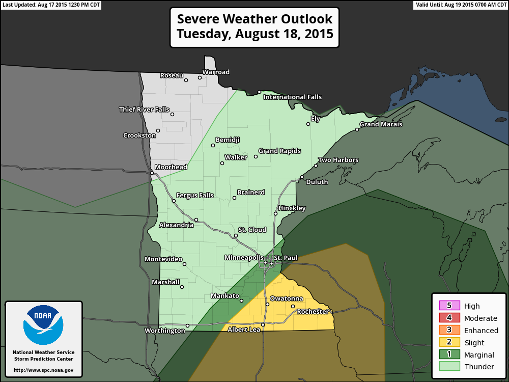
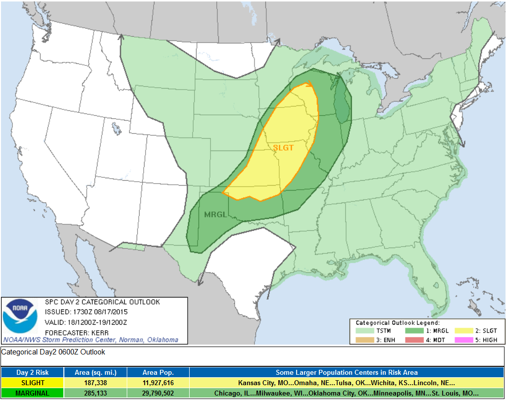
Severe Threat Tuesday
As
the storm system slides through the Upper Midwest, strong to severe
storms may be possible on Tuesday. Parts of Minnesota and Wisconsin are
under a SLIGHT RISK of severe weather.
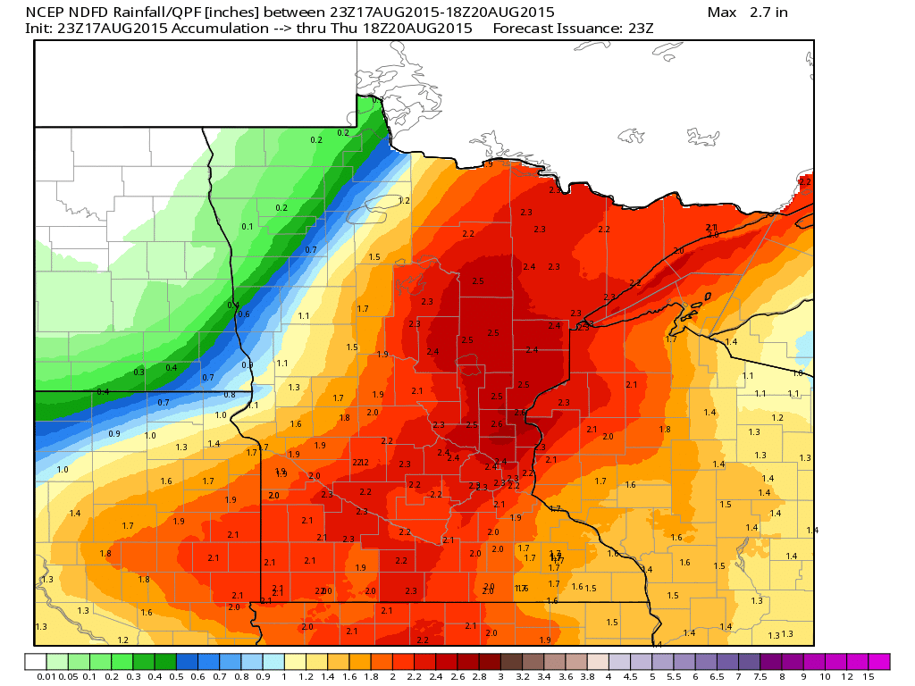
Rainfall Potential
Heavy rain and localized areas of flooding can't be ruled out as the storm system slides through the region. Widespread 1" to nearly 2"+ amounts may be possible through PM Wednesday.
______________________________________________
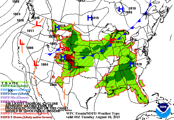
National Weather Outlook
Watch how quickly the are of low pressure in the loop below develops. From Monday to Wednesday winds surrounding the low will increase dramatically. Wind gusts on Wednesday could be as high as 30mph+ across the Upper Midwest as the storm slides northeast into Canada. The trailing cold front will be responsible for strong to severe storms over the coming days with locally heavy rainfall.
Severe Threat Tuesday
...SUMMARY... STRONG TO SEVERE STORM DEVELOPMENT IS POSSIBLE TUESDAY INTO TUESDAY NIGHT FROM THE LOWER CENTRAL PLAINS INTO PARTS OF THE UPPER MISSISSIPPI VALLEY. ...SYNOPSIS... A SIGNIFICANT PERTURBATION APPEARS TO BE CONTRIBUTING TO AMPLIFICATION WITHIN THE MID-LATITUDE WESTERLIES...WITH MID/UPPER RIDGING NOW BUILDING ACROSS THE NORTHEASTERN PACIFIC INTO THE BRITISH COLUMBIA COAST. THIS RIDGING IS FORECAST TO SHIFT INLAND ACROSS AND EAST OF THE CANADIAN ROCKIES LATER TODAY THROUGH TONIGHT...WHILE DOWNSTREAM TROUGHING BEGINS TO DEEPEN ACROSS AND EAST OF THE NORTHERN U.S. ROCKIES. TUESDAY INTO TUESDAY NIGHT...MODELS INDICATE THAT A VIGOROUS...PROGRESSIVE SHORT WAVE IMPULSE WILL BEGIN TO SUPPRESS THE RIDGING...BUT SUBSTANTIAL FURTHER DEEPENING OF THE DOWNSTREAM TROUGH IS FORECAST ACROSS THE NORTHERN U.S. PLAINS INTO THE UPPER MISSISSIPPI VALLEY. GUIDANCE REMAINS SUGGESTIVE THAT THIS WILL BE ACCOMPANIED BY SIGNIFICANT LOW/MID-LEVEL CYCLOGENESIS ACROSS THE MIDDLE MISSOURI VALLEY INTO THE UPPER MIDWEST. CONSIDERABLE SPREAD CONCERNING THESE DEVELOPMENTS REMAINS EVIDENT AMONG THE VARIOUS MODELS AND MODEL ENSEMBLE OUTPUT. HOWEVER...ASSOCIATED LARGE-SCALE FORCING FOR ASCENT PROBABLY WILL CONTRIBUTE TO A CONSIDERABLE INCREASE IN THUNDERSTORM ACTIVITY ACROSS PORTIONS OF THE PLAINS AND MID/UPPER MISSISSIPPI VALLEY REGION. THIS MAY INCLUDE A FEW SEVERE THUNDERSTORMS.
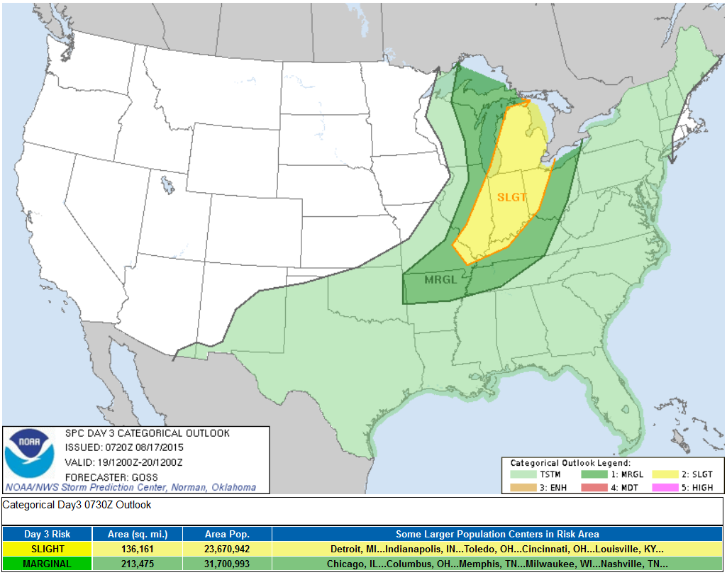
Severe Weather Wednesday
...SUMMARY... SCATTERED SHOWERS AND THUNDERSTORMS ARE FORECAST ACROSS THE SOUTH-CENTRAL AND EASTERN PORTIONS OF THE COUNTRY WEDNESDAY. THE ZONE WHERE ISOLATED SEVERE RISK APPEARS MOST LIKELY AT THIS TIME EXTENDS FROM LOWER MICHIGAN SOUTH-SOUTHWEST TO THE LOWER OHIO/MID MISSISSIPPI VALLEYS. ...SYNOPSIS... EWD PROGRESSION OF THE CENTRAL U.S. UPPER TROUGH WILL CONTINUE DAY 3...WITH THE SYSTEM PROGGED TO TAKE ON AN INCREASINGLY NEGATIVE TILT AS IT BEGINS LIFTING NEWD ACROSS THE GREAT LAKES TOWARD ONTARIO THROUGH THE SECOND HALF OF THE PERIOD. MEANWHILE...SECONDARY TROUGHING IS FORECAST TO BEGIN DIGGING SEWD OUT OF WRN CANADA TOWARD THE WRN U.S. WITH TIME. AT THE SURFACE...A WELL-EVOLVED SURFACE LOW IS FORECAST TO SHIFT NEWD ACROSS THE WRN UPPER GREAT LAKES REGION TOWARD ONTARIO WITH TIME...WHILE A TRAILING COLD FRONT ADVANCES QUICKLY EWD ACROSS THE GREAT LAKES/MIDWEST/OH VALLEY REGION...AND MORE SLOWLY SEWD/SWD ACROSS THE MID MS VALLEY/OZARKS/SRN PLAINS. THIS FRONTAL ZONE WILL FOCUS A BROAD AREA OF WIDESPREAD CONVECTION THROUGH THE PERIOD.
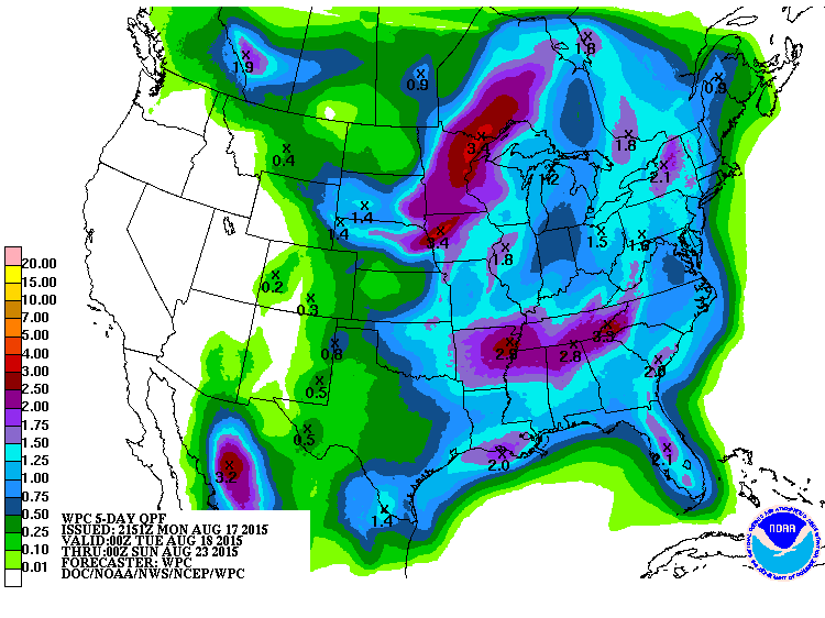
5 Day Precipitation Outlook
According to NOAA's HPC, the rainfall forecast looks quite impressive across parts of the eastern of the U.S. through Saturday. Some of the heaviest looks to fall across parts of the Upper Midwest with as much as 2" to nearly 3"+ possible, which may lead to localized areas of flooding. Meanwhile, note that the western part of the country looks to stay mostly dry, which is unfortunate news for several large wildfires that continue to burn there.
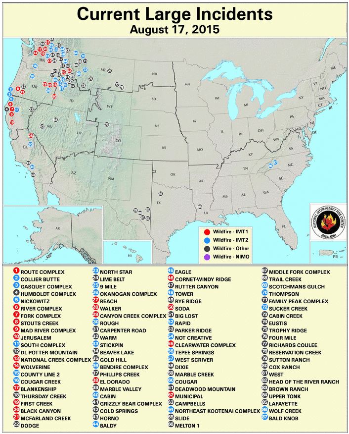
Large Fire Map
This map from the National Interagency Fire Center suggests several large wildfires buring in the Western U.S.. A large Incident is described as a wildfire of 100 acres or more occuring in timber, or a wildfire of 300 acres or more occurring in grass/sage.
Here were the latest stats as of August 17th:
National Preparedness Level
Level 5
National Fire Activity
Initial attack activity: Light (176 new fires)
New large incidents: 11
Large fires contained: 5
Uncontained large fires: 95
Area Command Teams committed: 2
_____________________________________
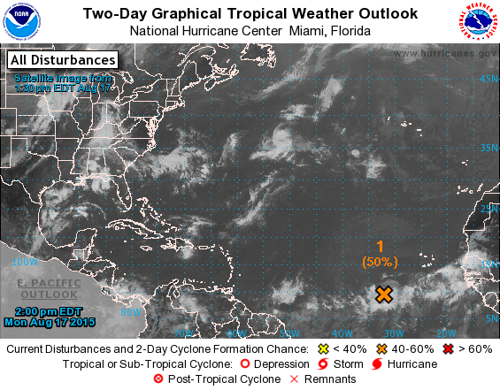
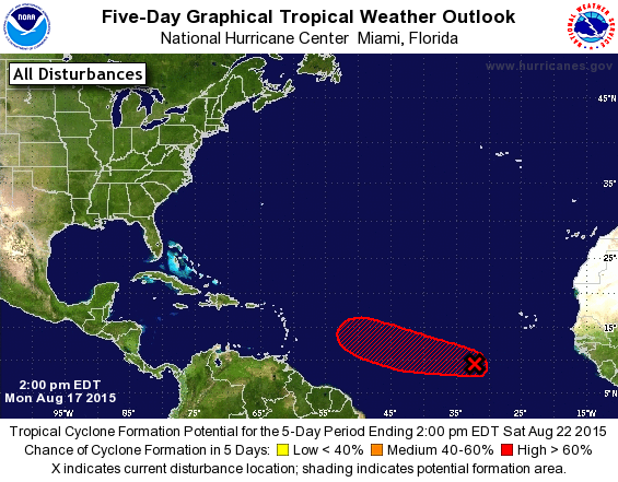
What's Brewing in the Atlantic?
It has been a very quiet so far this season in the Atlantic basin. There have only been 3 tropical system through mid August, but another one may be developing.
"On Monday morning, NHC was monitoring an area of low pressure located over the far eastern Atlantic Ocean several hundred miles southwest of the Cape Verde Islands. The shower activity associated with it continues to show signs of organization. Environmental conditions appear conducive for development during the next few days, and a tropical depression will likely form by the middle of the week while the system moves westward or west-northwestward."
TROPICAL WEATHER OUTLOOK NWS NATIONAL HURRICANE CENTER MIAMI FL 200 PM EDT MON AUG 17 2015 For the North Atlantic...Caribbean Sea and the Gulf of Mexico:
1. Shower and thunderstorm activity associated with an area of low pressure located several hundred miles southwest of the Cape Verde Islands continues to show signs of organization. Environmental conditions appear conducive for development over the next several days, and a tropical depression will likely form by the middle of the week while the system moves westward or west-northwestward near 15 mph.
* Formation chance through 48 hours...medium...50 percent
* Formation chance through 5 days...high...70 percent
See more from the National Hurricane Center HERE:
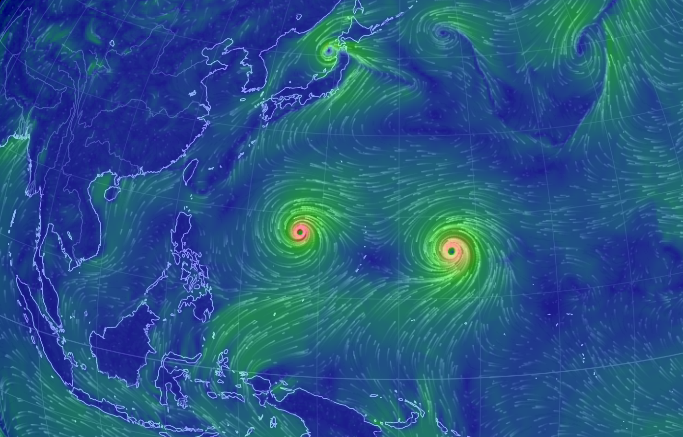
Problems in the Pacific Ocean
Take a look at the dual typhoons in the Western Pacific. GONI and ATSONI are strong typhoon heading west. Unfortunately, the western-most typhoon (GONI) could impact Taiwan again by late this week! ATSONI looks to steer more northwesterly.
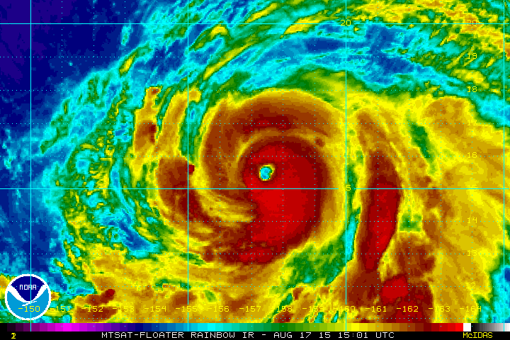
Typhoon GONI
This was Typhoon GONI from Monday evening (CDT), which was equivalent to a low end category 4 storm with sustained winds up to 132mph. Unfortunately, GONI is tracking west toward Taiwan and could be there later this week...
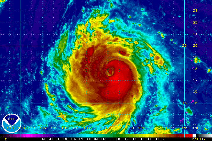
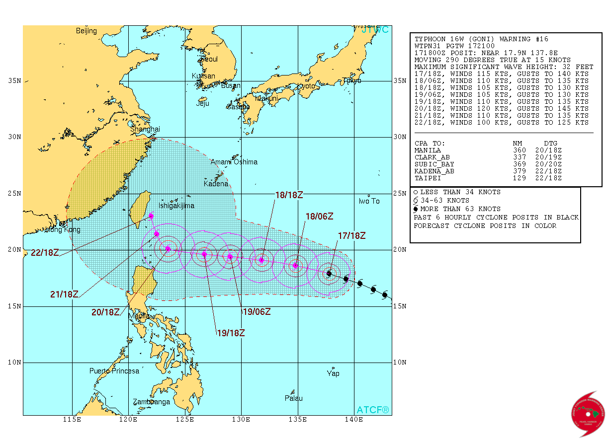
Typhoon GONI Track
According to the Joint Typhoon Warning Center, Typhoon GONI is tracking west toward Taiwan and could be there by Saturday. It'll be interesting to see whether or not GONI stays on its current track. It would be unfortunate to see another strong typhoon hit Taiwan after last week strong Typhoon SOUDELOR
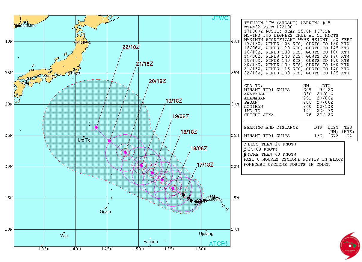
Typhoon ATSONI
According to The Joint Typhoon Warning Center, Typhoon ATSONI was an equivalent category 3 hurricane with sustained winds of near 120mph. ATSONI could become a Super Typhoon with sustained winds near 160mph by midweek!
Tracking ATSONI
The good news is that this typhoon is expected to track a little more northwestern rather than westerly like GONI. At this point, ATSONI looks to be a bigger problem for ships and slow moving whales... stay tuned.
_________________________________
Thanks for checking in and have a great rest of your week! Don't forget to follow me on Twitter @TNelsonWX

No comments:
Post a Comment