Thanks to Brian Peterson for the picture below who snapped this from a Minnesota roadside. Tis the season for sunflowers! I am actually growing a few in my garden this year and I am hoping I will be able to harvest some of the seeds. It doesn't look too dificult, so I will let you know how it turns out.

Partly Confusing
By Paul Douglas
"Climate is what we expect, weather is what we get" mused Mark Twain. Weather and climate are flip-sides of the same coin. Forecasting the weather requires models that use calculus to describe how the fluid of air overhead SHOULD move, but the equations aren't a perfect representation, thus the slings & arrows of a constantly changing 7-Day Outlook.
The only thing tougher than predicting the weather is communicating it, especially when it changes every 5 minutes, every 5 miles. We select our words carefully but it's Mission Impossible most days. We can give you the big picture, tell you WHY the pattern is the way it is and set broad expectations.
And no, partly sunny and partly cloudy don't mean the same thing. Partly sunny implies clouds most of the day, while partly cloudy means more sun than clouds. Rain implies steady, widespread coverage, whereas showers are hit and miss. When in doubt, mumble.
Another beautiful week is brewing; a faint Canadian fling into midweek before warming up late
week. The GFS hints at a few 90-degree days in late August, but no pangs of incandescent heat are imminent.
Overall this has been a summer to remember - the ride's not over just yet.
_________________________
SUNDAY NIGHT: Slight chance of a shower or t-storm early. Low: 65. Winds: N 5mph
MONDAY: Partly sunny, less humid. DP: 60. High: 80. Winds: N 5-15.
MONDAY NIGHT: Mostly clear. Low: 60. Winds: NNW 5-10
TUESDAY: Bright sun. Pretty much perfect! High: 80
WEDNESDAY: Warm sunshine. Still quiet and dry. Wake-up: 63. High: 84
THURSDAY:More clouds, passing T-shower. Wake-up: 67. High: 85.
FRIDAY: Hello July. Sticky sunshine. DP 64. Wake-up: 69. High: 87.
SATURDAY: Go jump in a lake. T-storms at night. Wake-up: 68. High: 88.
SUNDAY: Unsettled. Passing T-shower possible. Wake-up: 70. High: 84.
___________________________
This Day in Weather History
August 10th
2004: Cool Canadian air was ushered in on strong northwest winds. International Falls had its coldest high temperature ever for this date with 49 degrees. The Twin Cities only saw a high of 59.
1939: Cloudburst at Two Harbors. 5.2 inches of rain fell.
____________________________
Average High/Low for Minneapolis
August 10th
Average High: 82F (Record: 101F set in 1947)
Average Low: 63F (Record: 46F set in 1904)
_____________________________
Sunrise/Sunset Times for Minneapolis
August 10th
Sunrise: 6:09am
Sunset: 8:27pm
______________________________
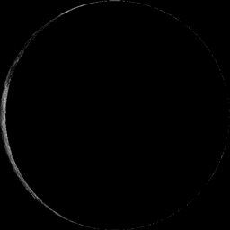
Moon Phase for August 10th at Midnight
3.3 Day Before New Moon
__________________________________
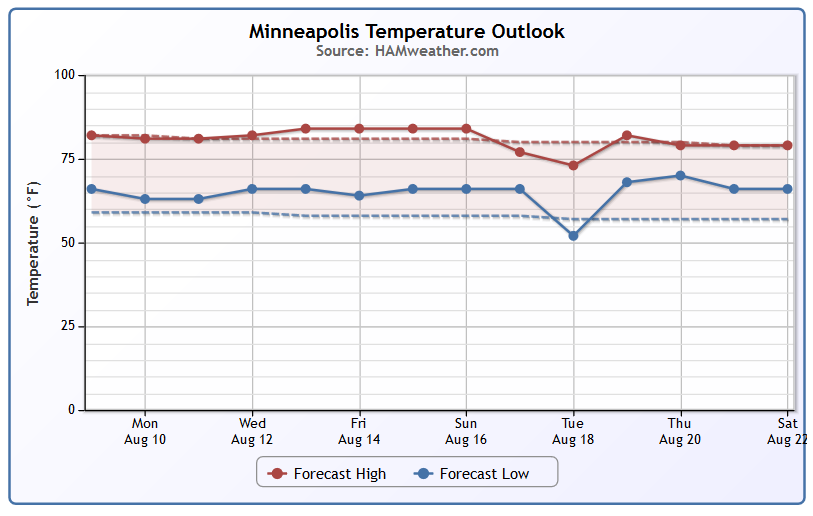
Minneapolis Temperature Trend
Ahhh... Nothing wrong with that forecast, right? At or near normal temperatures look to continue through the week ahead with slightly warmer, more humid conditions building in by the end of the week/weekend. Interestingly, I still don't see any major heat waves or cold snaps ahead. What a summer it has been! Keep it coming!
Monday Weather Outlook
After a somewhat unsettled weekend, weather conditions will improve as we head through the early week time frame. Temperatures will warm into upper 70s and low 80s across the state with dewpoints a little lower than this weekend. Slow clearing will take place Monday with more sun expected later in the day. Tuesday and Wednesday look nearly perfect for early/mid August. The next best chance of rain/thunder will be during the second half of the week.
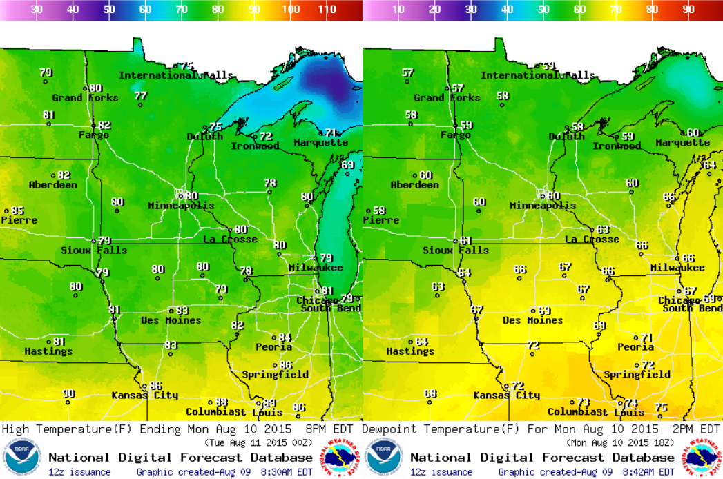
Monday Weather Outlook
Somewhat unsettled weather conditions will slide south of the region on Monday with a slow clearing trend. Winds out of the north/northwest will help to drop humidity levels slightly from what we had over the weekend.
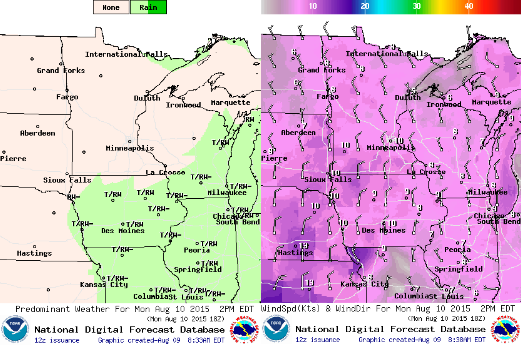
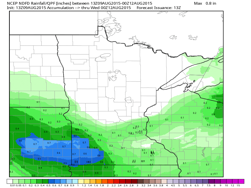
Rainfall Potential
Lingering rainfall from over the weekend will continue to slide south. It appears that mostly dry weather will take over through midweek, so your lawn and garden may need a little manual watering.
_______________________________________
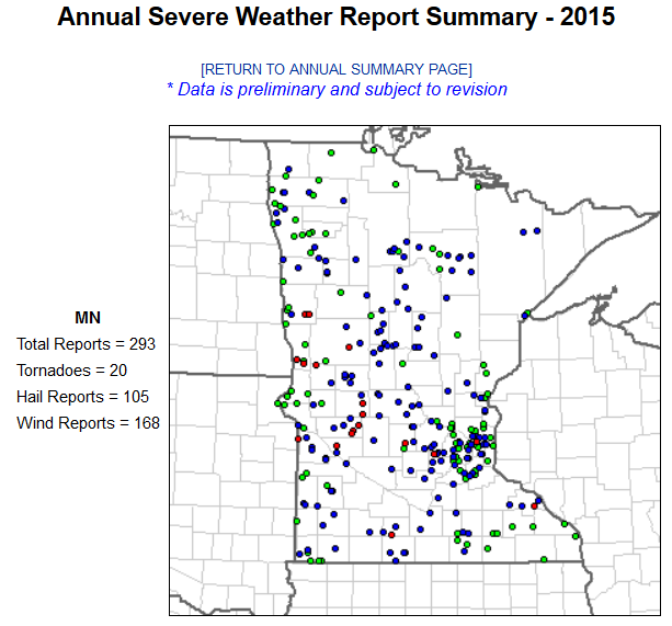
2015 Minnesota Severe Storm Reports
According to NOAA's SPC, there have been nearly 300 severe storm reports across the state with 20 of those reports being tornadoes. According to NOAA's NCDC, we should have had 37 tornado reports through the end of July.
2015 Preliminary Tornado Count
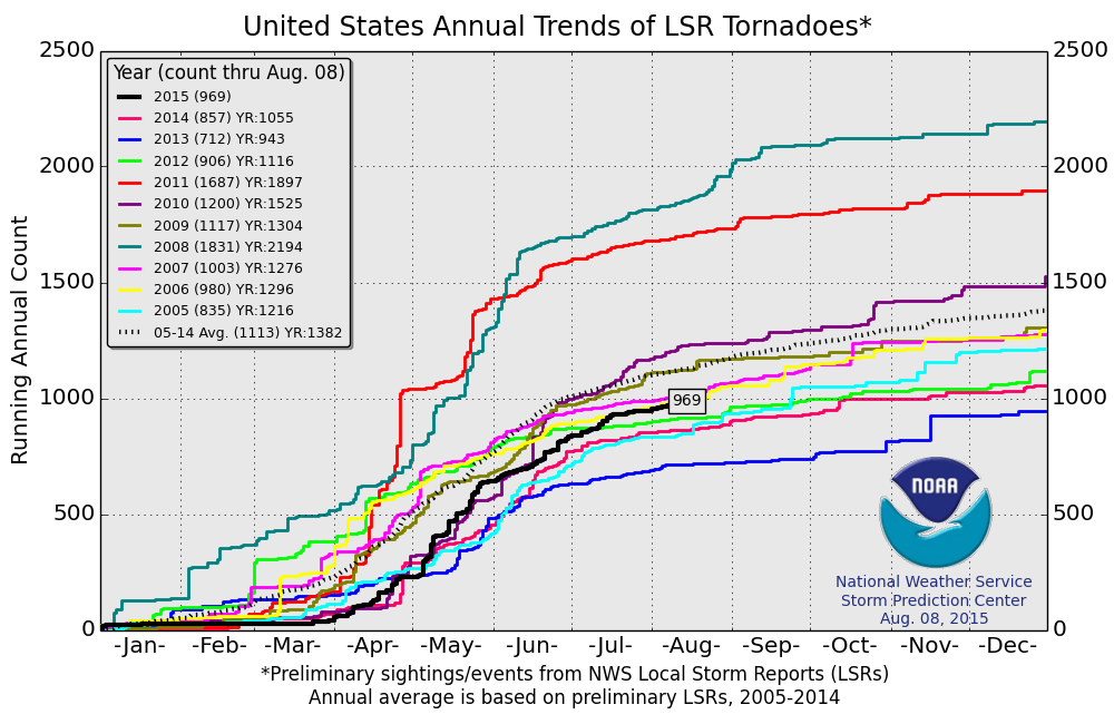
The preliminary tornado count suggests that there have been nearly 970 tornado reports across that nation. It appears that we are still running below the 2005-2014 average, which is ~1,100 tornadoes through August 8th. Note that the last 3 years, we have actually had fewer tornadoes than this year through August 8th.
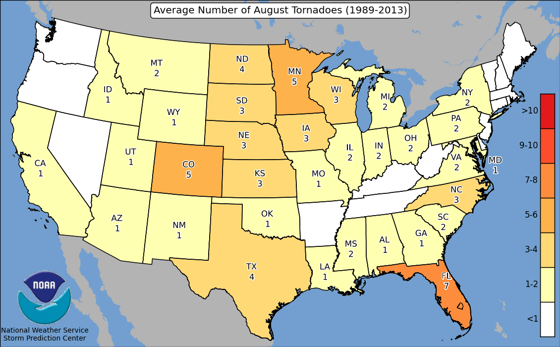
Average Number of Tornadoes in August By State
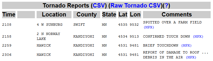
According to NOAA, the 1989-2013 average number of tornadoes in Minnesota during the month of August is 5. On Thursday, August 6th, there were 4 PRELIMINARY tornado reports in the western part of the state.
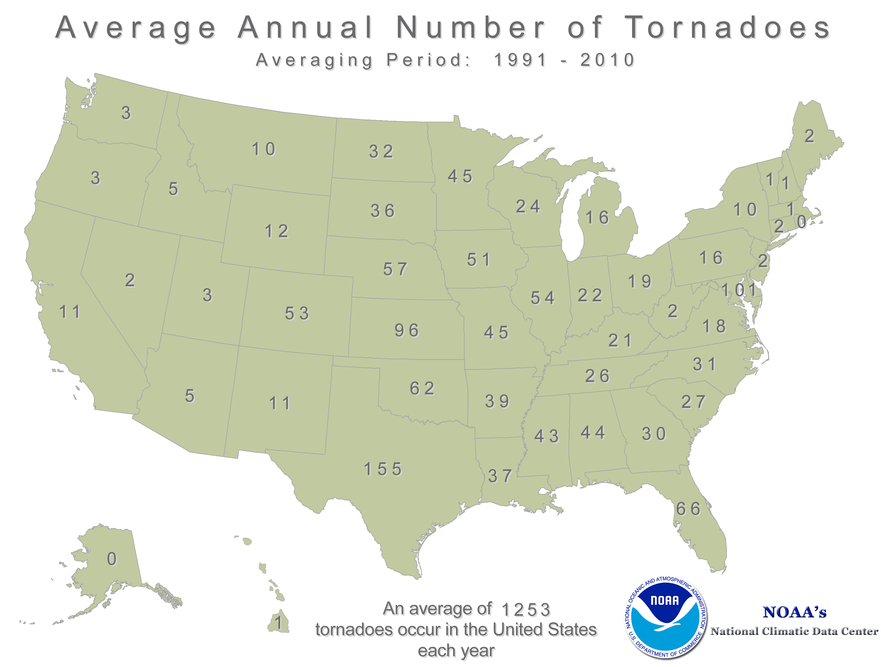
Average Annual Tornado Reports By State
According to NOAA's NCDC, the annual average number of tornadoes for the state of Minnesota is 45. Through early August, Minnesota has seen nearly half of that amount.
____________________________________
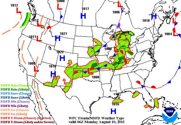
National Weather Outlook
The somewhat unsettled weather that we had over the weekend will continue sliding east toward the East Coast. It appears that storm system will intensify a little more to create a slightly better chance of more widespread strong/severe storms and heavy rainfall east of the Mississippi River.
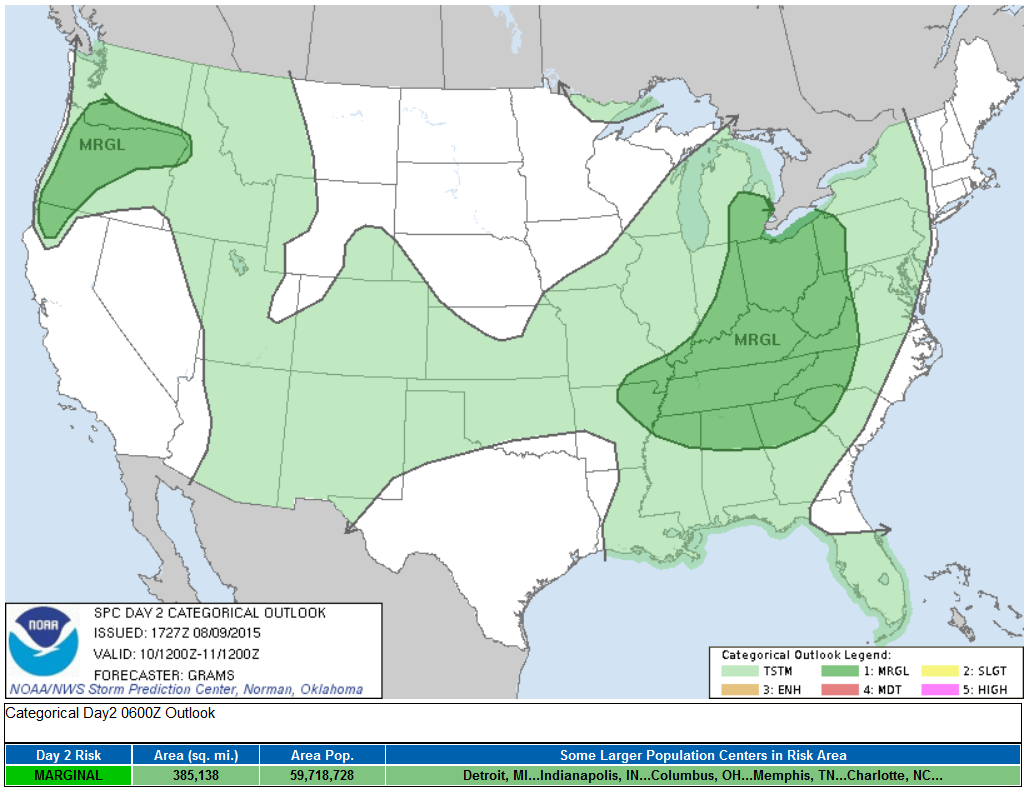
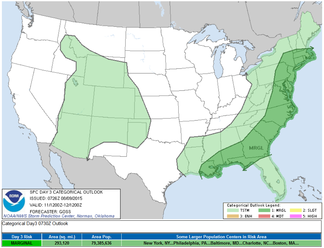
Severe Threat Monday
...SUMMARY... SCATTERED STORMS WITH LOCALIZED STRONG WIND GUSTS PRODUCING DAMAGING WINDS ARE EXPECTED FROM THE LOWER GREAT LAKES ACROSS THE OHIO/TENNESSEE VALLEYS TO THE SOUTHERN APPALACHIANS DURING THE AFTERNOON TO EARLY EVENING ON MONDAY. ISOLATED SEVERE WINDS WILL BE POSSIBLE OVER PARTS OF THE PACIFIC NORTHWEST IN THE LATE AFTERNOON TO EVENING.
Severe Threat Tuesday
...SUMMARY... SHOWERS AND THUNDERSTORMS -- INCLUDING SOME POTENTIAL FOR ISOLATED STRONGER/SEVERE STORMS -- ARE EXPECTED ALONG THE ATLANTIC AND GULF COAST STATES. SHOWERS AND STORMS WILL ALSO OCCUR ACROSS PORTIONS OF THE FOUR CORNERS STATES/INTERMOUNTAIN WEST AND EWD INTO THE HIGH PLAINS. ...SYNOPSIS... LITTLE CHANGE IN THE OVERALL LARGE-SCALE FLOW FIELD ALOFT IS PROGGED FOR DAY 3/TUE. 8-12...AS A LARGE/DEEP LOW LINGERS OFF THE CA COAST AND A SECOND TROUGH/VORTEX AFFECT THE ERN U.S. AND ADJACENT ERN CANADA. IN BETWEEN...A BROAD RIDGE WILL ENCOMPASS MUCH OF THE ROCKIES AND PLAINS STATES.
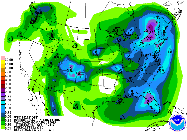
5 Day Precipitation Outlook
According to NOAA's WPC, the 5 day rainfall outlook suggests some of the heaviest and more widespread rainfall potential in the eastern third of the county. The intensifying storm system could bring as much as 1" to 2" or more to parts of the Northeast through midweek. Note that California looks to stay mostly dry through the week ahead.
Flying Through a Thunderstorm?
I recently came across this in my Twitter feed and was in shock! A flight from Boston to Salt Lake City encountered a thunderstorm east of Denver Colorado that had baseball size hail. The plane's nose and windshield were destroyed, but thankfully the pilots were able to put it into autopilot mode and make a safe landing in Denver!
Here's the full story from ABCNews

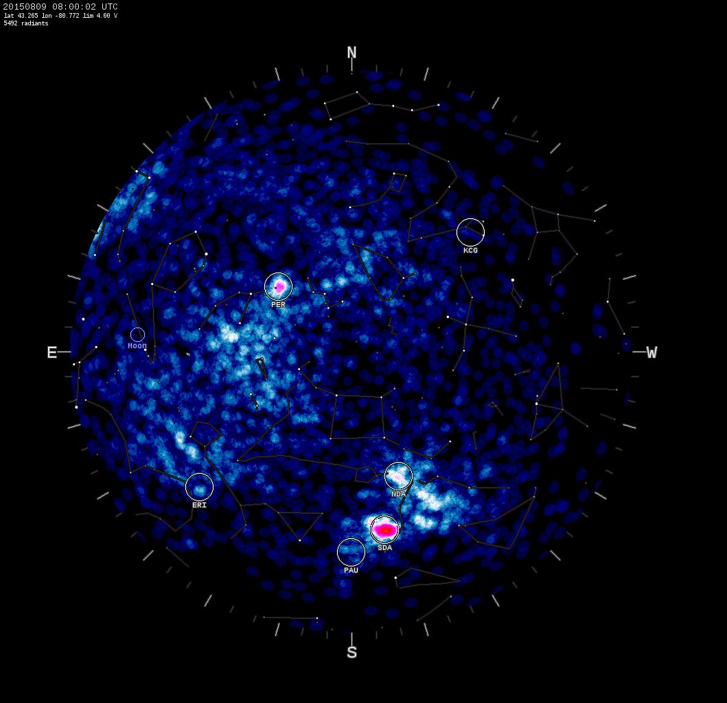
"Earth is Crossing Two Comet Debris Streams"
Nighttime sky watchers are likely giddy about the annual Perseid meteor shower that is expected to peak this week! While most of the nighttime meteors will come from the debris field of the comet Swift-Tuttle, another ancient sun grazing comet will help to make the night sky more active.
"Perseids come from 109P/Swift-Tuttle, a large comet with a rich debris stream. The shower is expected to peak this year on August 12-13 with as many as 100+ meteors per hour. Of all the meteor showers of the year, the Perseids produce the most fireballs. While we are waiting for the Perseids to peak, the Southern Delta Aquarid meteor shower is making its own contribution. Caused by debris from an ancient sungrazing comet, this shower produces 10 to 20 meteors per hour every year in late July and early August."
See more from SpaceWeather.com HERE:
Thanks for checking in and have a great week ahead! Don't forget to follow me on Twitter @TNelsonWX

No comments:
Post a Comment