Thanks to my good friend Scott Albrecht for the picture below who took this from just north of McGregor on Saturday evening. This particular storm was warned with with the possibility of 60mph wind gusts and half dollar size hail. Glad you guy got off the lake in time!!
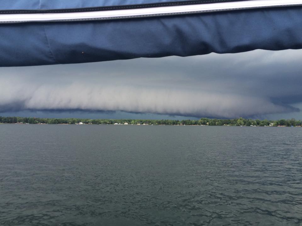
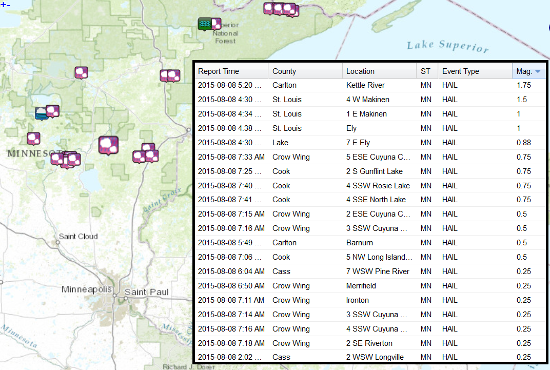
Saturday Storm Reports
____________________________________
Autobahn-buckling heat
By Paul Douglas
We live in our bubbles - it takes a fair amount of effort and technology to keep a global perspective. My business briefs Fortune 500 companies on global weather risk - is it a garden-variety storm or will operations be disrupted?
Taiwan's capital of Taipei just saw the second highest wind gusts ever recorded: 92 mph, courtesy of Typhoon Souledor. India and Myanmar have seen especially severe monsoon rains, leaving hundreds dead and nearly 1 million displaced. And 104-degree, pavement-buckling heat forced Germany's A8 Autobahn between Salzburg and Munich to drop speeds down to 50 mph! Relatively speaking we're getting off easy this summer, in spite of random storms and sporadic wind damage in some communities. It can always be worse.
Today won't win any awards; not quite postcard perfect - but enough sun for low 80s with a few instability T-storms mushrooming by late afternoon and evening. A fresh north breeze dries up any puddles early tomorrow as the dew point drops through the 60s into the 50s.
One of the best weeks of summer is shaping up with a winning-streak of sunny, increasingly warm days. No 90-degree sizzlers on the horizon but the State Fair is coming. Uh oh.
___________________________
SATURDAY NIGHT: Spotty showers/storms ending early. Low: 65. Wind: S 5-10.
SUNDAY: Some sun. Late PM T-storms. High: 81. Winds: SSE 5
SUNDAY NIGHT: Slight chance of a shower or t-storm. Low: 64. Winds: N 5mph
MONDAY: Partly sunny, less humid. DP: 61. High: 80. Winds: N 5-10.
TUESDAY: Bright sun. Pretty much perfect! Wake-up: 63. High: 83
WEDNESDAY: Warm sunshine. Still quiet and dry. Wake-up: 66. High: 86
THURSDAY:Patchy clouds, isolated thunder. Wake-up: 68. High: 87.
FRIDAY: Hello July. Sticky sunshine. DP 64. Wake-up: 69. High: 86.
SATURDAY: Go jump in a lake. T-storms at night. Wake-up: 70. High: 89.
_____________________________
This Day in Weather History
August 9th
1948: 7.72 inches of rain at Mankato.
______________________________
Average High/Low for Minneapolis
August 9th
Average High: 82F (Record: 95F set in 2010)
Average Low: 63F (Record: 46F set in 1972)
______________________________
Sunrise/Sunset Times for Minneapolis
August 9th
Sunrise: 6:08am
Sunset: 8:28pm
*Daylight lost since yesterday: ~2 minutes 37 seconds
*Daylight lost since summer solstice (June 21st): ~1 hour 15 minutes
_______________________________
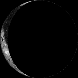
Moon Phase for August 9th at Midnight
3.2 Days After Last Quarter
__________________________________
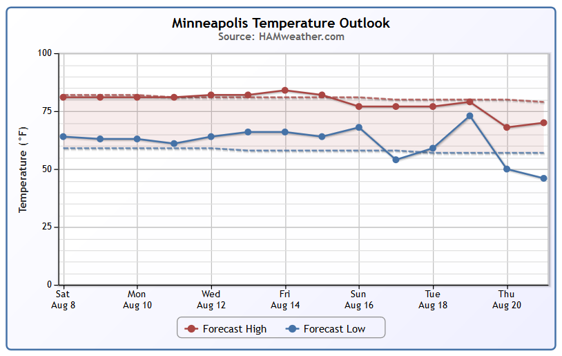
Minneapolis Temperature Trend
No complaints in the temperature department. Continued at or near average temperatures look to continue through much of next week with a slight warm up possible by the end of the week. Extended forecasts call for slightly below average reading by the 3rd week of August. It'll be interesting to see if the obligatory State Fair heat wave shows up at the end of the month... Stay tuned.
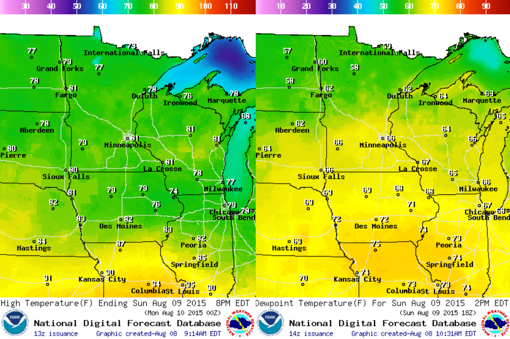
Sunday Weather Outlook
Sunday looks like another mild, but sticky day with dewpoints across the southern half of the state in the mid 60s. The hot and sticky stuff is still locked up to our south, note the 90s with dewpoints in the 70s across parts of Missouri. It's amazing to think that we really haven't had a lot of intense heat so far this summer.
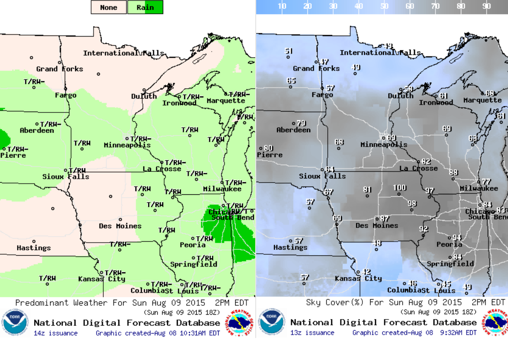
Sunday Weather Outlook
Sunday looks like another somewhat unsettled day with spotty showers and isolated thundershowers possible. The good news is that Sunday doesn't appear to be a washout, but we'll have to deal with the clouds once again.
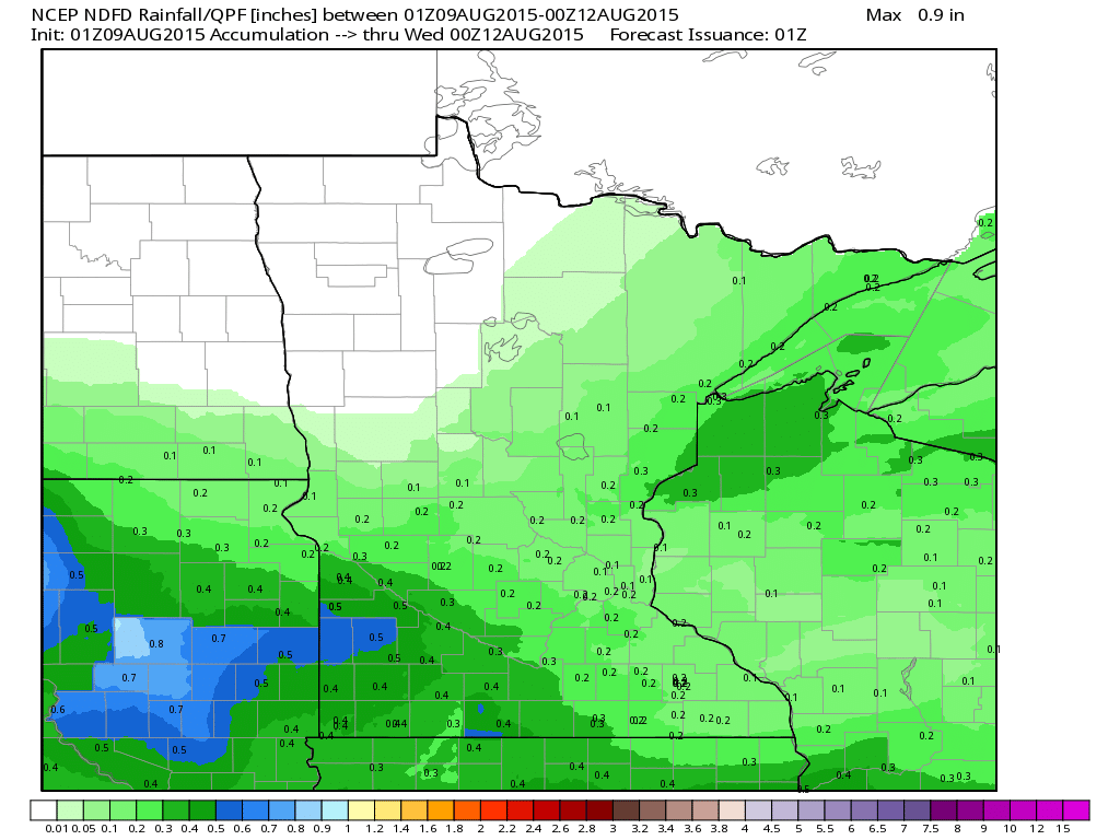
Rainfall Potential
Rainfall potential doesn't appear to be all that impressive across the state through early next week, but there could be pockets of 'heavier' stuff across parts of South Dakota and in parts of southwestern Minnesota.
______________________________
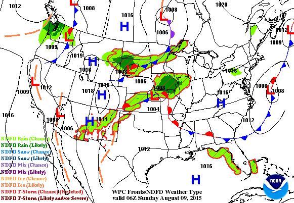
National Weather Outlook
Another impulse of energy will slide through the Midwest on Sunday keeping things a bit on the unsettled side. A few storms across the middle part of the country could be a little on the strong/severe side, but there aren't any major outbreaks brewing anytime soon.
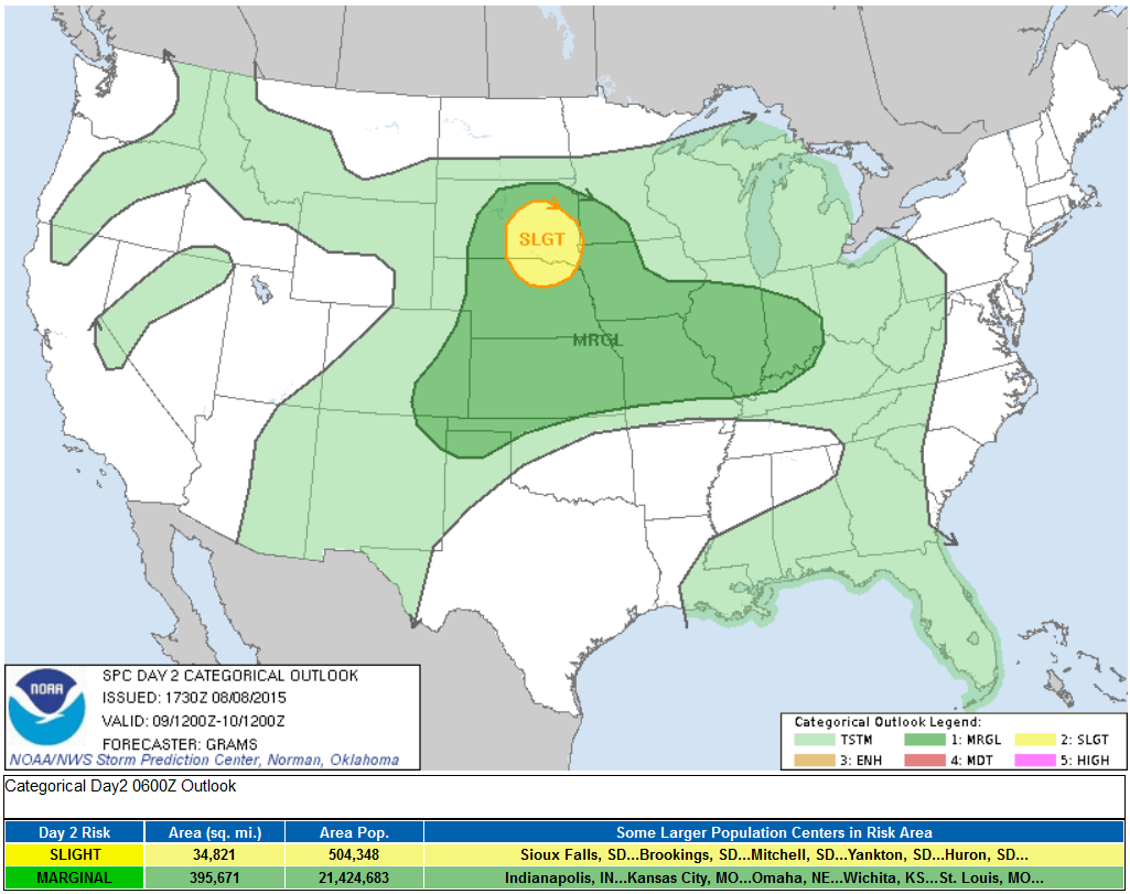
Severe Threat Sunday
...SUMMARY... SEVERE STORMS SHOULD DEVELOP ACROSS PARTS OF SOUTH DAKOTA AND NORTHERN NEBRASKA DURING THE AFTERNOON AND EVENING ON SUNDAY. A FEW CLUSTERS OF SEVERE STORMS ARE POSSIBLE FROM THE SOUTH-CENTRAL HIGH PLAINS TO THE MIDWEST BUT WITH LOW CONFIDENCE IN SPATIOTEMPORAL DETAILS.
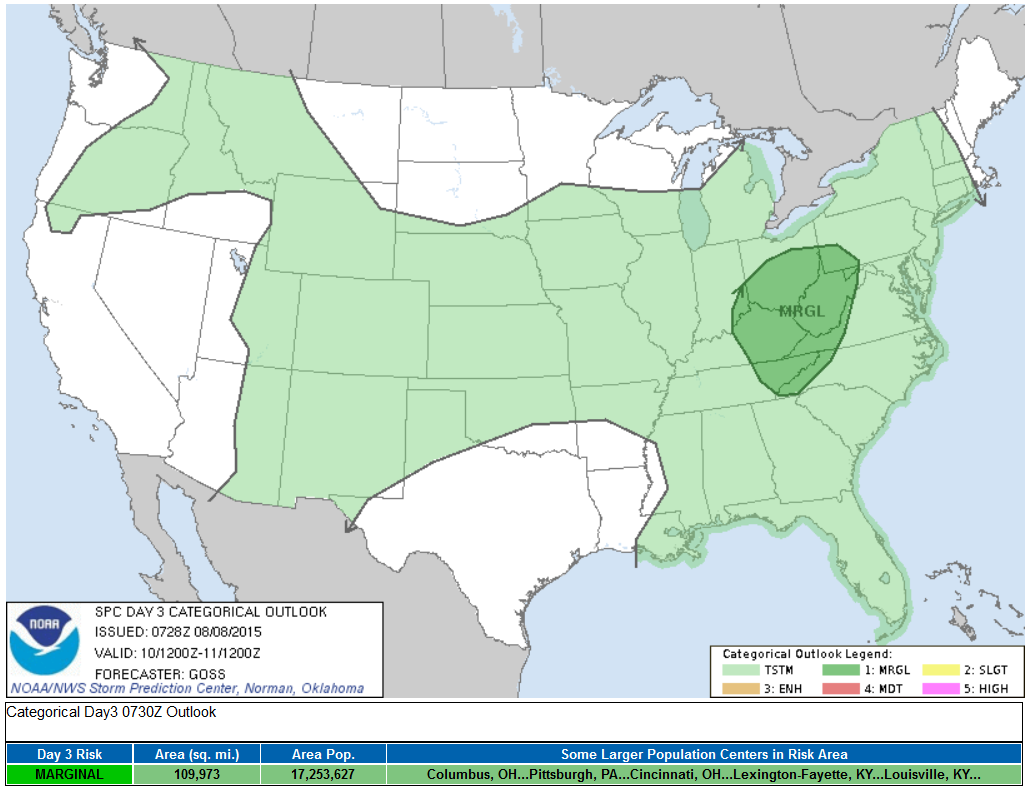
Severe Threat Monday
...SUMMARY... RELATIVELY WIDESPREAD STORMS ARE FORECAST FOR MONDAY ACROSS PARTS OF THE MID AND UPPER OHIO VALLEY AND CENTRAL APPALACHIANS...WITH LOCALLY GUSTY/DAMAGING WINDS POSSIBLE WITH A FEW OF THE STRONGER STORMS. ...SYNOPSIS... CONTINUED/GRADUAL AMPLIFICATION OF THE UPPER FLOW FIELD OVER THE U.S. IS EXPECTED MON...AS AN ERN PACIFIC LOW/TROUGH APPROACHES THE W COAST AND CONCURRENT EXPANSION OF ERN U.S. TROUGHING OCCURS AS SHORT-WAVE ENERGY DIGS SEWD INTO THE MEAN LONG-WAVE TROUGH. IN BETWEEN THESE TWO TROUGHS...STOUT CENTRAL NOAM RIDGING WILL PREVAIL.
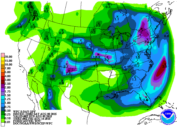
5 Day Precipitation Outlook
Heavy pockets of rain/flood potential will continue in an arc-like fashion around the intense heat locked up in the south-central part of the country. Some of the heaviest and most widespread rainfall looks to be across the eastern U.S., especially in the Northeast where 1" to near 3" can't be ruled out through the middle part of next week.
______________________________________
Soudelor Slams Taiwan
The reports and images coming from Taiwan are quite devastating. Incredible rainfall amounts have led to flash flooding and mudslides leading to water rescues, injuries and even fatalities.
"A large mudslide sweeps through a Taiwanese mountain village after typhoon Soudelor makes landfall. A river of mud is seen careening through Taoyuan, in the country’s northwest, carrying with it trees and homes. Soudelor hit the small island nation on Saturday morning, leaving at least four people dead, and dozens injured, according to local media"
See more from TheGuardian.com HERE:

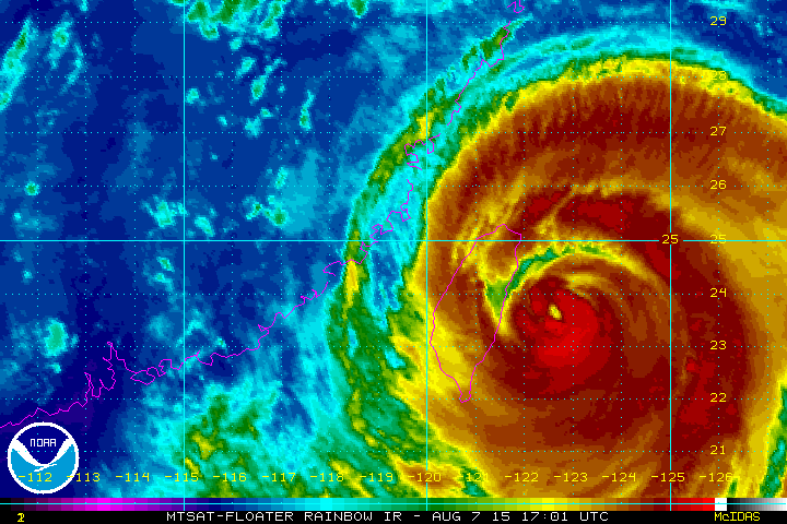
Typhoon Soudelor
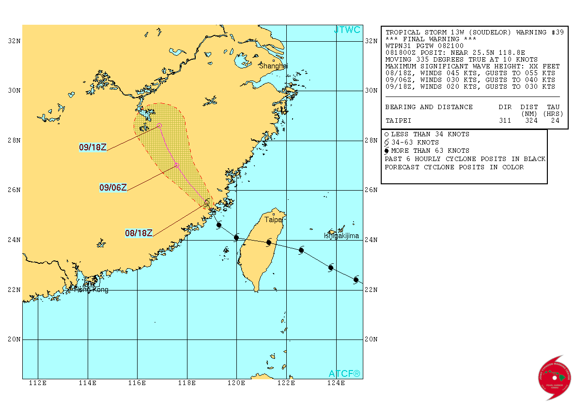
As of early Saturday CDT, Typhoon Soudelor was just barely equivalent to hurricane status with sustained winds near 74mph. The rapid weakening was due to Soudelor moving over Taiwan. Unfortunately, several injuries and fatalities were blamed on the storm that was equivalent to a category 3 hurricane just prior to landfall. Note how the apparent "Eye" of the storm collapses as it moves over Taiwan.
Soudelor Track
According to the Joint Typhoon Warning Center, continued weakening will continue as Soudelor tracks through eastern China through the rest of the weekend. Although winds won't be such an issue, heavy rainfall and flooding could be.
_____________________________
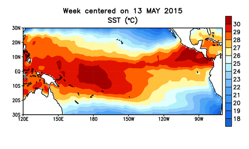
El Nino Update
"Synopsis: There is a greater than 90% chance that El Niño will continue through Northern Hemisphere winter 2015-16, and around an 80% chance it will last into early spring 2016."
"Across the contiguous United States, temperature and precipitation impacts associated with El Niño are expected to remain minimal during the Northern Hemisphere summer and increase into the late fall and winter. El Niño will likely contribute to a below normal Atlantic hurricane season, and to above-normal hurricane seasons in both the central and eastern Pacific hurricane basins (click Hurricane season outlook for more)."
See more from NOAA's ENSO Updated Outlook HERE:
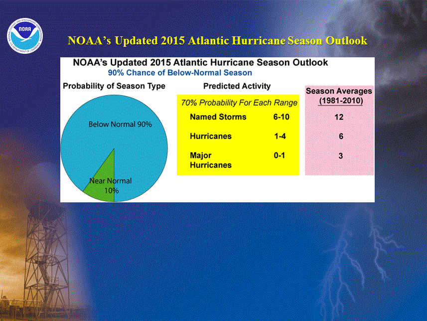
Updated Atlantic Hurricane Season Outlook
Several factors are playing a part is what looks like a below average Atlantic Hurricane Season. The updated outlook was released by NOAA on August 6th, which states:
Based on the current and expected conditions, combined with model forecasts, we estimate a 70% probability for each of the following ranges of activity during the 2015 hurricane season:
6-10 Named Storms, which includes the three named storms to date
1-4 Hurricanes
0-1 Major Hurricanes
Accumulated Cyclone Energy (ACE) range of 25%-70% of the median.
"NOAA's updated 2015 Atlantic Hurricane Season Outlook indicates that a below-normal hurricane season is very likely. The outlook calls for a 90% chance of a below-normal season and a 10% chance of a near-normal season, with no realistic expectation that the season will be above-normal. This 90% probability of a below-normal season is the highest given by NOAA for any such season since their seasonal hurricane outlooks began in August 1998."
"The likelihood of a below-normal hurricane season has increased for three main reasons. First, El Niño has strengthened as predicted, and NOAA's latest prediction calls for a significant El Niño to continue through the remainder of the hurricane season. Second, atmospheric conditions that are exceptionally non-conducive to tropical storm and hurricane formation are now present in response to El Niño. These conditions, which include strong vertical wind shear and enhanced sinking motion, are predicted to continue through the peak months (August-October, ASO) of the hurricane season across the Atlantic hurricane Main Development Region (MDR, which spans the Caribbean Sea and tropical Atlantic Ocean between 9oN-21.5oN; Goldenberg et al. 2001). Third, sea-surface temperatures (SSTs) across the MDR are predicted to remain below average, and to also remain much cooler than the rest of the global tropics. Cooler Atlantic SSTs are associated with stronger trade winds, and further reduce the ability of storms to form and gain strength in the MDR."
________________________________________
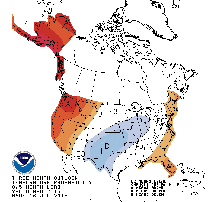
3 Month Temperature Outlook
According to NOAA's CPC, the 3 month temperature outlook suggests above average temperatures continuing across Alaska and the Western U.S.. Note that there looks to be a fairly decent swath of potentially below average temperatures developing across the middle part of the country.
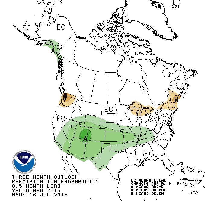
3 Month Precipitation Outlook
NOAA's CPC suggests chances of above average precipitation across parts of the Desert Southwest into the middle part of the country. While it's nice to see parts of California in this area, it would be nice to see the whole state in the green.
_______________________________-
Thanks for checking in and have a great rest of your weekend! Don't forget to follow me on Twitter @TNelsonWX

No comments:
Post a Comment