47 F. morning low on Saturday at MSP International Airport.
69 F. afternoon high temperature yesterday.
73 F. average high on September 12.
56 F. high on September 12, 2014.
September 12, 1982: Two tornadoes touched down in Benton County. The F2 tornado caused $250,000 worth of damaged and the F0 caused $25,000.
September 12, 1931: The fifth consecutive day of 90 degrees or above in the Minneapolis area.
September 12, 1923: Snow pays an early visit to northern Minnesota. Some cities that saw flurries and sleet were Roseau and Virginia.
September 12, 1903: 4.96 inches of rain fell in the Minneapolis area.
September 12, 1869: A hail storm between 1 and 3 am broke windows and caused considerable damage to late vegetables at Madelia in Watonwan County.
 Career Perspective
My sincere thanks to the
Pavek Museum of Broadcasting for inducting me into the Minnesota Broadcasting Hall of Fame last night. I'm honored, but trying to keep a little perspective.
"You're
never as bad as your critics say you are - or as good as your fans
think you are. Live a life of perpetual humility" my father warned me a
long time ago. Good advice.
My Navy son had an interesting observation. "That's great Dad! Next stop: wax museum." It's nice how kids have a way of pulling you back down to Earth.
I
have no regrets; it was a great ride at KARE-11 and WCCO-TV. Today I'm
working without a (TV) net on a weather technology and media production company. As media goes from a speech to a
conversation my team is trying to reinvent the way consumers and
companies receive personalized, actionable weather updates. Now we're
all walking around with shiny supercomputers in our pockets and purses.
This changes everything
Clear Lake, Minnesota woke up to 28F
Saturday
morning. Any frosty memories will be quickly erased by a stiff south
wind, luring the mercury into the 80s this week. A growl of thunder is
possible by
Wednesday; skies clear and temperatures cool off by next weekend.
With
a Super El Nino in the Pacific I see a mild bias the next 8 months.
Winter is coming, but probably not a harsh, pioneer winter.
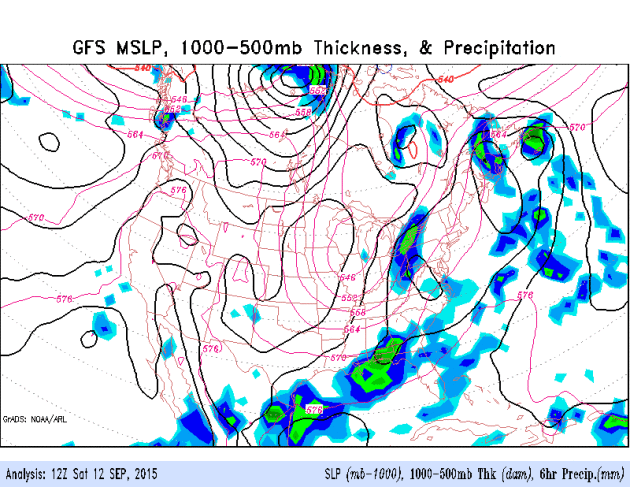
10-Day Model.
NOAA's GFS model shows dry weather persisting into at least Wednesday
morning; a growing chance of spotty T-storms late Wednesday into Friday
morning before the next, inevitable cool front flushes fresh, Canadian
air south of the border. We warm up well into the 70s again next week.
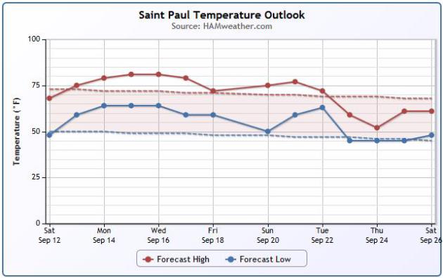
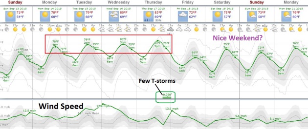
Trending Milder Than Average.
Not exactly a heat wave, but low 80s in mid-September is still nothing
to sneeze at. The graphic above, courtesy of AerisWeather, shows the
normal ranges of both highs and lows at St. Paul; daytime highs running
5-10F warmer than average into next weekend.
Dry Into Tuesday.
Models show a little rain by the middle of next week, possibly a
quarter inch or so from scattered showers and T-showers Wednesday into
Thursday. Source: Aeris Enterprise.
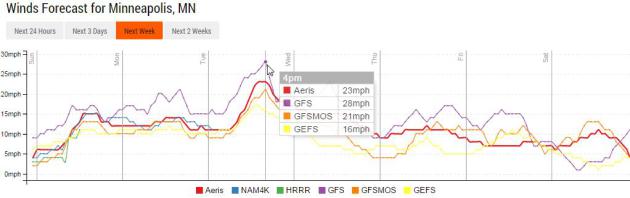
Gusty South Winds.
Models are in fairly good continuity or alignment, showing sustained
winds in the 20-25 mph+ range by Tuesday before easing up late in the
week.
A Case for September.
This is why I like September: much less humidity, far fewer wild
T-storms to track on Doppler, plenty of sun and temperatures still warm
enough to enjoy the lake (or the deck). Temperatures nudge or eclipse
80F from Monday into Thursday before cooling and clearing in time for
next weekend. European guidance suggests a few isolated T-storms
Wednesday and Thursday, but no soakers in sight. Source: WeatherSpark.
Supernaturally Quiet in the Tropics.
Historically, September 10 is the date hurricane landfalls are most
likely in the USA. It's been very quiet in the Atlantic and Caribbean,
the result of 3 factors: a building El Nino (which tends to increase
subtropical winds, shredding storms before they can really wind up), too
much dry air and too much Saharan dust. Even so, it would be premature
to let our guards down just yet.
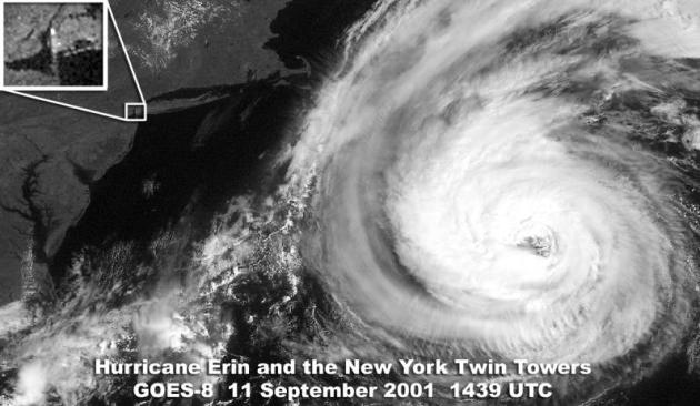
Rain and a Hurricane Almost Changed The Course of History on September 11, 2001.
Dennis Mersereau has an interesting story about the weather 14 years
ago - one of the few times a close encounter with a hurricane might have
been a good thing - possibly thwarting the 9/11 attack. Here's an
excerpt from
The Vane at Gawker: "...
If
the cold front had moved just a bit slower, the weather might not have
been as beautiful as it was on September 11. The timing of the frontal
passage cleared the skies and allowed the hijacked flights to depart
without delay, also affording those bastards clear visibility along
their flight paths. Not only that, but the cold front also kept
Hurricane Erin from drawing closer to the United States, which likely
would have affected both weather and air travel in New York and Boston
as airlines prepared for a potential strike from a formidable hurricane..."
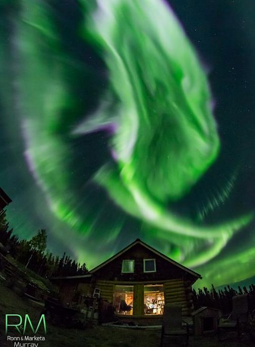
Geomagnetic Storm = Aurora Potential.
It's worth a shot - skies should be crystal clear again tonight with
low humidity and excellent visibility. There's no way to predict the
Northern Lights in advance, but Friday's storm on the sun has raised the
odds of seeing the Aurora Borealis. More details via
spaceweather.com: "
During
the early hours of Sept. 11th, a high-speed solar wind stream hit
Earth's magnetic field. The impact sparked a strong (Kp=7) geomagnetic
storm and Northern Lights in the USA as far south as Wisconsin and Washington State.
In Alaska, "the entire sky was moving like sea waves in colors of green
and purple," reports aurora tour guide Marketa Murray, who took this
picture outside Fairbanks..."
Photo credit above: Ronn and Market Murray.
Wet Start to September For Some Parts of Minnesota. Here's the intro to this week's installment of
Minnesota WeatherTalk, courtesy of Dr. Mark Seeley: "
The
first ten days of September have brought a month's worth of rainfall
and more for many locations in Minnesota. The monthly normal rainfall
for September ranges from 2.50 inches to 3.50 inches for most Minnesota
climate stations. Through the first 10 days of this month over 40
climate stations already report rainfall amounts within that range.
Brimson, Eveleth, Floodwood, Two Harbors, and Waseca have already
reported over 4 inches of rain for the month, while Cotton and Keewatin
have reported over 5 inches. On a few days several observers reported
significant thunderstorm rainfalls, in some cases establishing new daily
record rainfalls..."
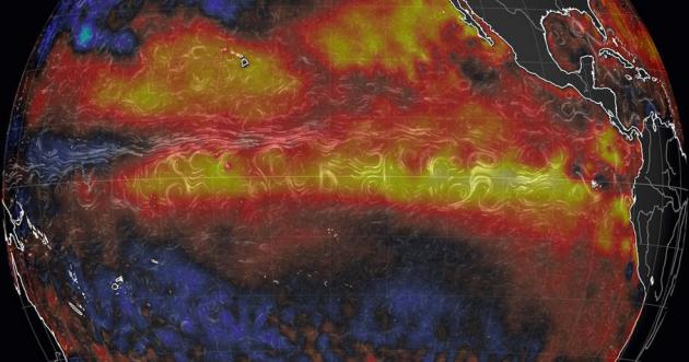
El Nino Reaches "Strong" Intensity; Will Dramatically Reshape The World's Weather.
It's not quite as intense as '97; not yet, but forecasts suggest 2-3C
of warming in the Pacific, which could - in theory - make it the
strongest El Nino ever recorded. It's still too early to say. Here's a
clip from an Andrew Freedman article at
Mashable: "
The
periodic climate cycle in the Pacific Ocean known as El Niño has
reached "strong" levels, according to scientists at the Climate
Prediction Center (CPC) in College Park, Maryland. The event commenced
in March and is forecast to have its peak influence on U.S. weather this
winter, before subsiding next spring. It ranks as the 2nd- to
3rd-strongest such event on record for this time of year, as measured by
the ocean temperature departures from average and other metrics,
forecasters said Thursday. It's possible that the ongoing event, which
should peak in the next several months, will eclipse the mother of all El Niño events,
which occurred in 1997-98, as well as another monster El Niño that
occurred in 1982-83. That is not assured, however, as it's not quite
there yet..."
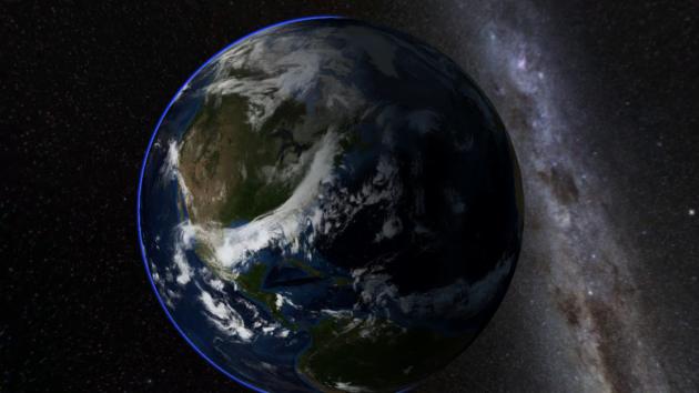
Image credit above: "
Sea surface
temperature anomalies along the equator, showing telltale stripe of
above average ocean waters, a hallmark of El Nino." Image:
Earth Simulator
The Active Hurricane Era That Brought Us Katrina and Sandy May Be Over. Then again, all it takes is one. We'll see if this is a prescient or premature. Here's an excerpt from a good overview at
Capital Weather Gang: "...
The
variations between active and inactive periods appear to be caused by
fluctuations in sea surface temperature patterns across the Atlantic
Ocean, known as the Atlantic Multidecadal Oscillation (AMO). When the
AMO is in its positive phase, there is typically a horseshoe-shaped
pattern in the ocean surface temperatures, with warmer than normal water
in the far northern Atlantic and the tropical Atlantic, and normal or
even cooler than normal temperatures off the East Coast..."
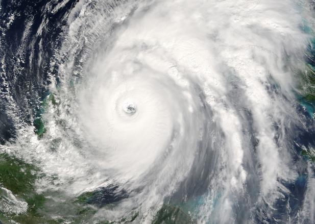
Image credit above: "
Hurricane
Wilma of 2005 was the last major hurricane to make landfall on the U.S.
coast. It came ashore in Florida as a category 3, after weakening from
its maximum intensity of category 5." (NASA)
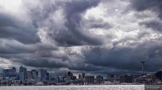
This Drought Is So Bad That Even Seattle Is Running Out of Water. Grist has the details; here's an excerpt: "
Hey,
Seattle. Remember last winter? How pleasantly warm and dry it was,
almost like you live somewhere reasonable and not in a pool of tepid
water near Canada? Well, you’re paying for it now. In a new article on
Investigate West, reporter Robert McClure looks at the future of the
city’s dwindling supply, and the results are Not Good. Representatives
from Seattle Public Utilities showed McClure models based on simulations
of future climate patterns, and the forecast is quite bleak..."
Image credit above:
Jacksonian/Flickr.
End of the Road for Reporters? Robot Reporter Churns Out Perfect, 1000-Word News Story - in 60 Seconds.
OK, but can you teach a robot to stand in front of a green screen and
point to Montana? Probably. Here's an excerpt of a vaguely terrifying
post at
South China Morning Post: "...
Chinese
social and gaming giant Tencent published its first business report
written by a robot this week, ramping up fears among local journalists
that their days may be numbered. The flawless 916 -word article was
released via the company’s QQ.com portal, an instant messaging service
that wields much sway in China, a country now in the throes of an automation revolution.
“The piece is very readable. I can’t even tell it wasn’t written by a
person,” said Li Wei, a reporter based in the southern Chinese
manufacturing boomtown of Shenzhen..."
TODAY: Lukewarm sun, pleasant. Winds: S 10-15. High: 76
SUNDAY NIGHT: Clear and pleasant. Low: 59
MONDAY: Warm sun, very nice. High: 81
TUESDAY: Sunny, hints of July. Wake-up: 63. High: 84
WEDNESDAY: Sticky sun, stray T-storm possible. Wake-up: 64. High: 85
THURSDAY: Murky sun, T-storms, especially up north. Wake-up: 65. High: 82
FRIDAY: Partly sunny, less humid. Wake-up: 60. High: 75
SATURDAY: Sunny, no complaints. Wake-up: 53. High: 73
Climate Stories....
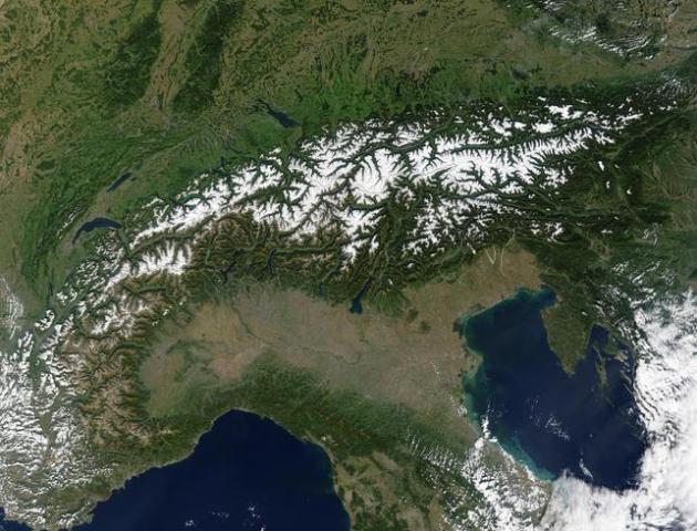
The Coming Of The Glacier Men. BBC News has a story about rapidly melting ice in the Alps, and what it's leaving behind; here's an excerpt: "...
All
sorts of things have been retrieved from Alpine snow and ice over the
year, from the remains of a crashed World War Two American bomber, to a
cache of emeralds, rubies and sapphires being carried on an Air India
flight which came down on Mont Blanc in 1966. But over the last two
decades the glaciers have retreated more rapidly, says Martin Grosjean, a
glacier specialist at the University of Berne's Oeschger Institute.
Even ice which has been permanent for thousands of years has started to
melt, giving rise to a new scientific discipline - glacial archaeology..." (Image: NASA).
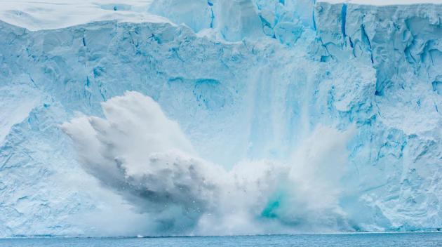
Study Predicts Huge Sea Level Rise If All Fossil Fuels Are Burned. Justin Gillis at
The New York Times has more details on the latest study; here's the introduction: "
Burning all the world’s deposits of coal, oil and natural gas would raise the temperature enough to melt the entire ice sheet covering Antarctica,
driving the level of the sea up by more than 160 feet, scientists
reported Friday. In a major surprise to the scientists, they found that
half the melting could occur in as little as a thousand years, causing
the ocean to rise by something on the order of a foot per decade,
roughly 10 times the rate at which it is rising now. Such a pace would
almost certainly throw human society into chaos, forcing a rapid retreat
from the world’s coastal cities..."
Photo credit above: "Calving
ice near Paradise Harbor in Antarctica in Jan. 2015. The continent's
ice sheet and the rest of the world's land ice would melt if all the
world's fossil fuels were burned, a new climate study found." Credit Ralph Lee Hopkins/National Geographic Creative
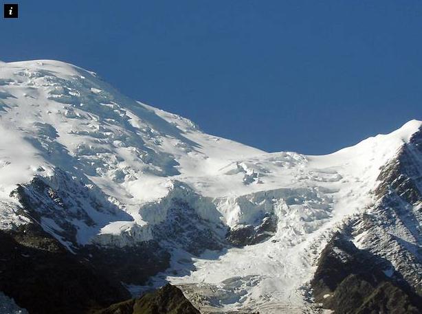
Global Warming Causing Record Rock Falls in the Alps, Experts Warn. Here's the intro to a story at
The Independent: "
A
French expert is predicting a record number of rock falls in the Alps
this year as rising temperatures, thought to be a result of climate
change, cause the permafrost to melt. A report on the website of French newspaper Le Monde
noted that at least 150 rock collapses (described as a rock fall of
more than 100 cubic metres) have been recorded on Mont-Blanc, the
highest peak in Europe, since the summer began..."
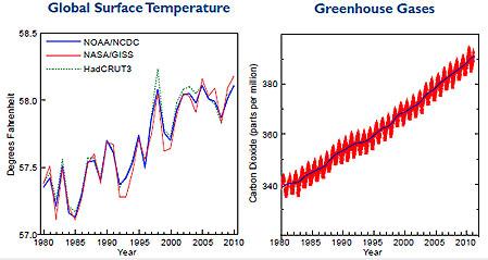
Climate Scientists Undermine Their Own Science by Avoiding the Best Case Scenario. But are we willing to gamble on a best case outcome? Are we - collectively - going to take that bet? Here's an excerpt from
Quartz: "...
Perhaps
I cling too strongly to my faith in rationality (my own bias), but I
believe most people can make smart decisions when faced with risk—they
just need to have it explained to them the right way. Conveying risk is
hard but it’s important to do, especially when there is a small, but
serious chance of facing danger. That’s why I was dismayed to read that
several climate scientists, normally a measured bunch who understand
risk and uncertainty better than anyone, are going rogue. Some are
moving off the grid. Others use more forceful language and underplay the uncertainty that still exists..."
Image credit: American Meteorological Society.


No comments:
Post a Comment