75 F. high temperature in the Twin Cities Sunday.
73 F. average high on September 13.
60 F. high on September 13, 2014.
September 13, 1994:
Lightning struck and injured a 35 year old man in Stearns county as he
opened the door of his truck. Witnesses said he was thrown 10 feet when
the lightning bolt struck him.
September 13, 1834: Smoky skies at Ft. Snelling due to fires burning nearby.
Back It UpIf
the house burned down, if (God forbid) an EF-5 tornado came
streamrolling through the neighborhood, I wouldn't miss our "stuff".
That can be replaced. The only thing I would anguish over is lost family
photos and videos. That's irreplaceable.
That's why I'm backing
up all every jpeg and movie onto Dropbox, Picasa and YouTube. That's my
fall and winter project - making sure there's a Plan B.
Which got
me thinking about our postcard-worthy weather; how lucky we've been here
at our lofty latitude. The western USA is suffering through historic
drought, running out of water, wildfires blazing. Dust from the Sahara
Desert and El Nino teamed up to disrupt hurricane formation in the
Atlantic; we've dodged a bullet again this year.
The older I get
the less I take for granted, and that applies to quiet, drama-free
weather. Storms may be good for business, but I'm just fine with
sedating Mother Nature for an extended period of time. It all evens out
in the end.
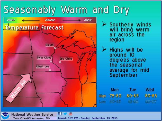
Warm, gusty winds blow 80s back into Minnesota this
week; late-week thunder giving way to more quiet, sunny, lukewarm
weather next weekend.
NOAA's GFS model hints at frost for the suburbs in about 2 weeks. Take a mental snapshot.
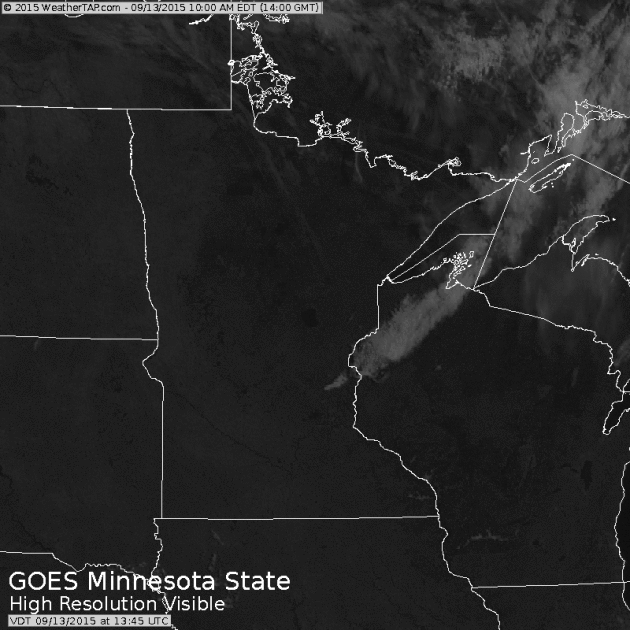
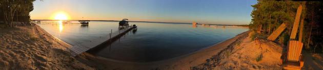
Nothing But Lakes.
It's rare that the entire state of Minnesota is this cloud-free, but
Sunday's midday visible satellite loop (courtesy of WeatherTap) shows
the crystal clear conditions we enjoyed yesterday. With the dry,
Canadian air the lakes really pop from a lofty altitude of 22,300 miles.
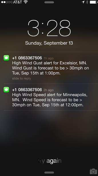
Windblown.
A lukewarm wind from the south is forecast to gust over 30 mph at times
by 1 PM today, according to AerisWeather. A strong pressure gradient
resulting from rapidly retreating cool air will put the squeeze on the
atmosphere, whipping up a few whitecaps on your favorite lake.
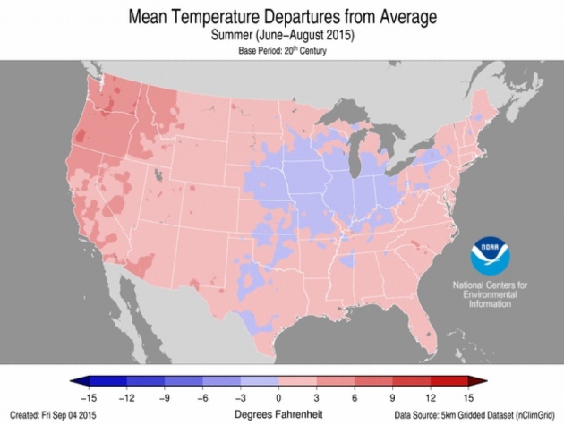
4 Western States Could See Warmest Year on Record. Here's a clip from
Climate Central that made me do a double-take: "...
Except
for a relatively cool oasis at the center of the country (created by
copious rainfall that helped keep temperatures down), most of the
country had above-normal temperatures for August, as well as the summer
as a whole. In particular, parts of New England, Hawaii and the Southern
Plains roasted in sometimes-record heat during the month. Two western
states — Washington and Oregon — had their hottest summers on record,
driven in part by stifling August weather. Those two states, along with
California and Nevada have recorded their warmest January-August, and
are poised to potentially see their hottest years ever..."
Image credit above: "
How temperatures departed from average during summer 2015 for the contiguous U.S." Credit: NOAA
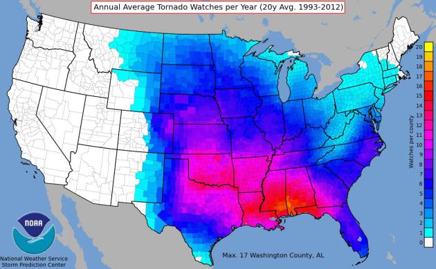
New Model Could Provide Tornado Forecasts Months in Advance.
Good luck with that. We may be able to forecast, with some vague skill,
when conditions are ripe for tornado formation, weeks or even months in
advance, but I'm a bit skeptical on this one. Here's an excerpt from Business Standard: "A
new model for predicting tornado activity could allow experts to
prepare forecasts months or even seasons in advance, scientists say.
"The aim is to predict ahead to the following year or subsequent years
about whether we'll get above or below average tornado activity in a
given area," said Vincent Cheng, a postdoctoral fellow in University of Toronto Scarborough (UTSC) Ecological Modelling Lab..."
Graphic credit: NOAA Storm Prediction Center.
Supernaturally Quiet in the Tropics.
Historically, September 10 is the date hurricane landfalls are most
likely in the USA. It's been very quiet in the Atlantic and Caribbean,
the result of 3 factors: a building El Nino (which tends to increase
subtropical winds, shredding storms before they can really wind up), too
much dry air and too much Saharan dust. Even so, it would be premature
to let our guards down just yet.
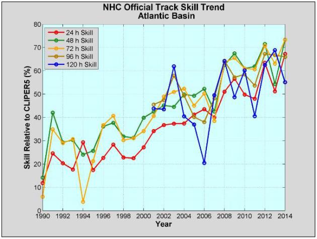
What's The Prediction for Hurricane Forecasting? Predictions are improving over time, especially track forecasts. Intensity remains problematic. Here's a clip from a story at
The Charlotte Observer: "...
Improvements
in observation systems – especially in research aircraft – and more
sophisticated data for projections have been prominent. “There are NASA
satellite sensors with much higher spatial resolution today as compared
to 2005,” said Venkat Lakshmi, a professor and hydrometeorology expert
at the University of South Carolina. Also, “input into numerical models,
the boundary layer and initial conditions has improved, making
predictions much better. As a matter of fact, now we have five-day
forecasts as compared to three-day forecasts in 2005...”
* The 2014 National Hurricane Center Verification Report is here.
Read more here: http://www.charlotteobserver.com/news/science-technology/article34958838.html#storylink=cpy
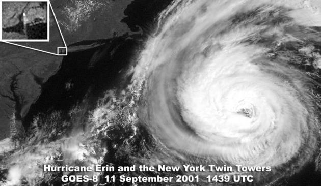
Rain and a Hurricane Almost Changed The Course of History on September 11, 2001.
Dennis Mersereau has an interesting story about the weather 14 years
ago - one of the few times a close encounter with a hurricane might have
been a good thing - possibly thwarting the 9/11 attack. Here's an
excerpt from
The Vane at Gawker: "...
If
the cold front had moved just a bit slower, the weather might not have
been as beautiful as it was on September 11. The timing of the frontal
passage cleared the skies and allowed the hijacked flights to depart
without delay, also affording those bastards clear visibility along
their flight paths. Not only that, but the cold front also kept
Hurricane Erin from drawing closer to the United States, which likely
would have affected both weather and air travel in New York and Boston
as airlines prepared for a potential strike from a formidable hurricane..."
TODAY: Warm sun, gusty winds. Winds: S 15-30+ High: 82
MONDAY NIGHT: Mostly clear and mild. Low: 64
TUESDAY: Sticky sun, still windy. Winds: S 15-30. High: 83
WEDNESDAY: Partly sunny, hello July. Dew point: 63. Wake-up: 65. High: 84
THURSDAY: Unsettled, few T-storms likely. Wake-up: 67. High: 82
FRIDAY: PM showers, thunder. Wake-up: 64. High: 76
SATURDAY: Lukewarm sun, pleasant. Wake-up: 57. High: 72
SUNDAY: Good timing. Mild sunshine. Wake-up: 58. High: 74
Climate Stories....
Global Warming Alert as El Nino Returns with a Vengeance. Here's the intro to a story at
Financial Times:
"The world is starting to heat up again, say British scientists,
raising speculation that a 15-year slowdown in the rate of global
warming could be coming to an end. A pause in the rate of global
temperature rises since the late 1990s has baffled climate scientists
and led some to question whether man-made
climate change was a serious problem. But last year was the
warmest on record,
according to the UN’s World Meteorological Organisation, and scientists
at the UK’s Met Office say both this year and 2016 are shaping up to be
just as hot..."
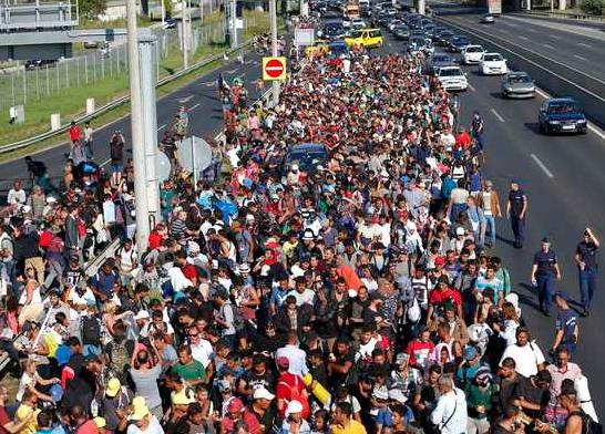
The Refugee Crisis is a Portent. A
fluke or a sign of things to come as climate refugees flee regions hit
by perpetual drought and water shortages? We'll see. Here's a clip from
Daily Kos: "...
In 2011, the National Oceanic and Atmospheric Administration
reported that climate change was "a major factor in more frequent
Mediterranean droughts." By 2013, researchers were linking the drought
in Syria to its civil war. A year ago, the Emmy Award-winning documentary Years Of Living Dangerously
further fleshed out the link between climate change and the war in
Syria, as well as growing violence over increasing water scarcity in
Yemen. Last spring, a peer-reviewed scientific study explicitly linked the Syrian war to climate change:
“It’s
a pretty convincing climate fingerprint,” said Retired Navy Rear Adm.
David Titley, a meteorologist who’s now a professor at Penn State
University. After decades of poor water policy, “there was no resilience
left in the system.” Titley says, given that context, that the
record-setting drought caused Syria to “break catastrophically...”
The "Fat Tail" of Climate Change Risk. Here's an excerpt of a story at
Huffington Post: "...
The
"insurance policy" analogy is appropriate here. We don't purchase fire
insurance on our homes because our homes are likely to burn down. Far
from it in fact: less than one-in-four homeowners are likely to ever
experience a house fire. We purchase fire insurance because we
understand that, even though such a catastrophic event is unlikely (less
than 25 percent chance of happening), if it did happen, it would be
catastrophic. So it is worth hedging against, by investing money now --
in the form of fire insurance..."
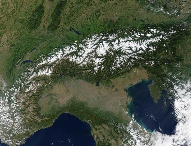
The Coming Of The Glacier Men. BBC News has a story about rapidly melting ice in the Alps, and what it's leaving behind; here's an excerpt: "...
All
sorts of things have been retrieved from Alpine snow and ice over the
year, from the remains of a crashed World War Two American bomber, to a
cache of emeralds, rubies and sapphires being carried on an Air India
flight which came down on Mont Blanc in 1966. But over the last two
decades the glaciers have retreated more rapidly, says Martin Grosjean, a
glacier specialist at the University of Berne's Oeschger Institute.
Even ice which has been permanent for thousands of years has started to
melt, giving rise to a new scientific discipline - glacial archaeology..." (Image: NASA).


No comments:
Post a Comment