WOW! Thanks to my good friend Stephanie Chanaka Johnson for the picture below. This was taken over the weekend of one of our last (meteorological summer) sunsets of the year. Smoke from western wildfires helped to produce some brilliant smokey sunrises and sunsets over the last several days. The full moon rises and sets were pretty nice too!! Hope you enjoyed them!!

Smoke and Wildfire Analysis
Airnow.gov has a neat map that shows daily the wildfire and smoke analysis across the country. The map below shows how widespread the smoke was from Tuesday, September 1st. Note that most of the fires are in the western U.S., while much of the smoke was still across the central and eastern U.S..
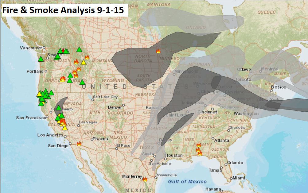
Wednesday Smoke Analysis
NOAA also has a neat smoke analysis map. This is the forecast for Wednesday at 2pm, which show that much of the smoke from western wildfires will have lifted north into Canada. The threat for smokey sunrises/sunsets has ended for much of the central/southern part of the country... for now.

Low Expectations
By Paul Douglas
"It is best to read the weather forecast before praying for rain" said Mark Twain. There is now little doubt that major holidays attract puddles. Mother Nature has a wicked sense of humor. T-storms are in the forecast for the Labor Day weekend. Trying to time the rain this far out is an act of futility, but the skies will be rumbling every now and then, especially Sunday. The farther north you go, the better the odds of a few hours of hard rain.
The Dog Days of September limp on, with a heat index in the mid-90s almost every day into Saturday. If you're heading off to the State Fair stay hydrated and take plenty of breaks.
A little perspective is in order: during a typical summer MSP picks up 14 days at or above 90F. So far in 2015: only 4 days of 90-degree heat. In 2013 we enjoyed 7 days in the 90s during the State Fair! That was a truly whine-worthy spasm of late-summer heat. This warm spell is tame, by comparison.
An isolated thundershower may bubble up later today as dew points surge into the low 70s. Sweaty weather extends into Labor Day before a puff of slightly cooler, drier air arrives.
With a Super El Nino in the Pacific I'm predicting warmth well into October.
_________________________
TUESDAY NIGHT: Muggy and warm. Low: 70. Winds: S 5mph
WEDNESDAY: Steamy with intervals of sun, isolated T-shower. Dew point: 70. High: 85. Winds: 5-15 mph
WEDNESDAY NIGHT: Partly cloudy, slight chance of thunder. Low: 71
THURSDAY: Hello July! Hot sunshine. High: 88.
FRIDAY: Murky sun, late-day thunder risk. Wake-up: 72. High: 88
SATURDAY: Free sauna lingers. Sticky sun. Wake-up: 72. High: 90
SUNDAY: Best chance of t-storms, some heavy. Wake-up: 71. High: 86
LABOR DAY: More 4th of July than Labor Day with some sun, isolated thunder. Wake-up: 71. High: 87
TUESDAY: Breezy, turning less humid. Wake-up: 66. High: 78.
___________________________
This Day in Weather History
September 2nd
1996: Approximately 8 inches of rain fell over 2 1/2 hour period in the Mankato area resulting in flash flooding. Numerous road were closed, basements flooded and $100,000 of damage from a lightning strike in Lehiller.
1992: Severe weather affected several counties in the western parts of the County Warning Area. Several tornadoes were reported along with 3/4 inch hail and damaging winds as the system passed through Pope, Swift, Stearns, Kandiyohi, Meeker, Brown and Renville Counties.
1975: Severe weather rolled through Stevens, Swift, Kandiyohi, and Meeker counties. 1.50 inch Hail was reported in Stevens and Swift. An F1 tornado also occurred in Swift at the time that the hail was reported. An hour later another F1 Tornado was reported in Kandiyohi County while 69 knot winds occurred in Meeker County. Damages were estimated at $50,000 for the two tornadoes that touched down.
1937: Severe thunderstorms over northern Minnesota, with 4.61 inches of rain dumped on Pokegama. Flooding was reported in Duluth.
_____________________________
Average High/Low for Minneapolis
September 2nd
Average High: 77F (Record: 97F set in 1937)
Average Low: 58F (Record: 42 set in 1974)
______________________________
Sunrise/Sunset Times for Minneapolis
September 2nd
Sunrise: 6:35am
Sunset: 7:50pm
_____________________________
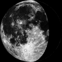
Moon Phase for September 2nd at Midnight
2.1 Days Before Last Quarter
__________________________________
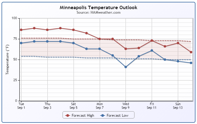
Minneapolis Temperature Trend
Welcome to the dog days of September! Well above average temperatures look to continue through the upcoming weekend; a shot at 90F is not out of the question. Scattered showers and storms move in over the weekend/early next with a memorable cold front sneaking in by midweek as temperatures dip into the 70s. Enjoy the warmth while you can, we all know what's around the corner...
____________________________
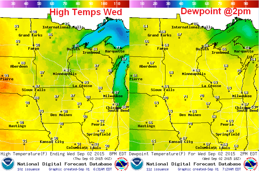
Wednesday Weather Outlook
Wednesday looks like another warm and muggy day with readings more July-like. Highs will will warm into the mid/upper 80s across much of the region with a few low 90s possible across far western MN and through the Dakotas. Note that dewpoints will climb into the mid/upper 60s as well, which is considered quite sticky at any time of the year!
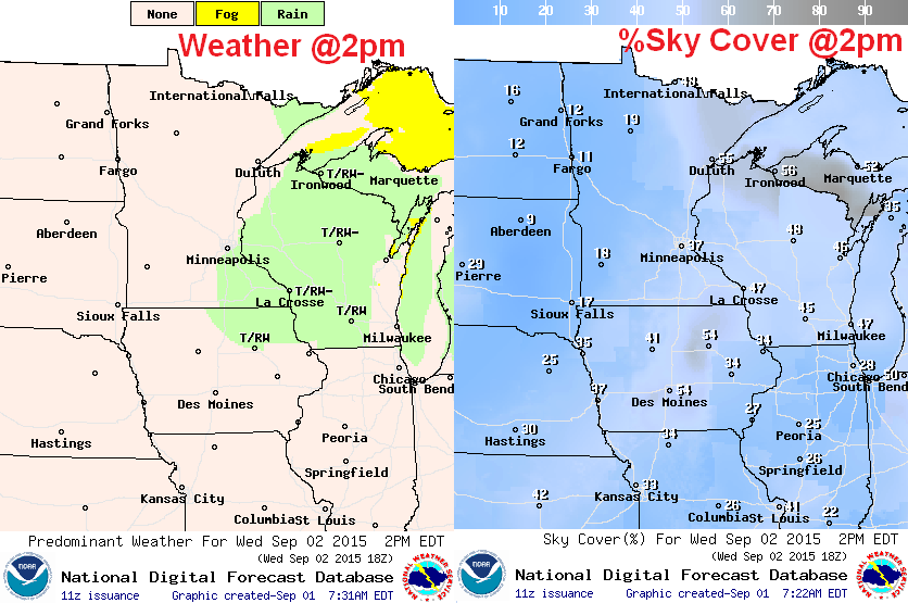
Wednesday Weather Outlook
A weak boundary will be in place helping to promote a little spotty shower/thunderstorm potential. The images below suggests weather and % sky cover around 2pm. Note that the best chance of t-shower activity looks to be across Wisconsin and far southeastern MN.
Wednesday Weather Outlook
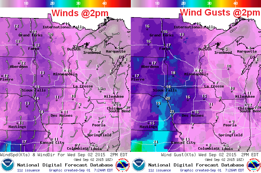
Flashbacks of summer will unlimited today as a somewhat breezy south wind continues. Wind gusts could at times approach 20mph, especially across western Minnesota.
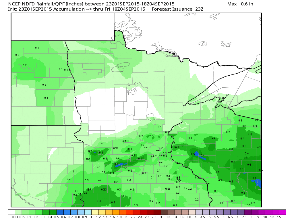
Rainfall Potential
Spotty showers and storms will be possible across the region over the next couple/few days, but according to the rainfall forecast below, we're not expecting much. In the meantime, we'll be left to tend to our lawns and gardens manually as this warm and 'mostly' dry weather continues through midday Friday.
National Weather Outlook
The loop below actually looks pretty quiet doesn't it? To be honest, there isn't much in terms of widespread heavy rain or any big storms brewing through Thursday. Pockets of heavy rainfall will be possible in the Southwest, Southwest and in the Northwest, but other than that... it's a pretty quiet and warm start to September.
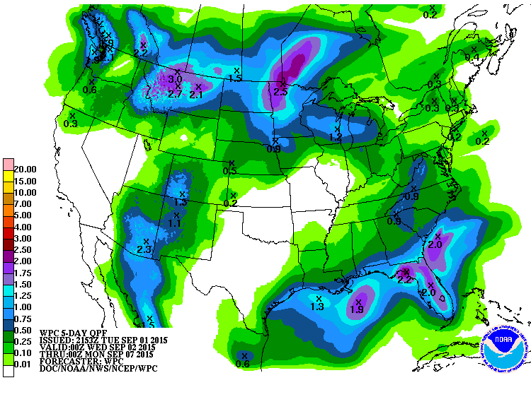
5 Day Precipitation Outlook
According to NOAA's WPC, the 5 day precipitation forecast shows some of the heaviest rainfall potential over Florida and across parts of the northern tier of the nation. Florida will be dealing with some lingering tropical moisture, while impulses of energy (from a large low pressure system in the Gulf of Alaska) continue to skirt along the international border.
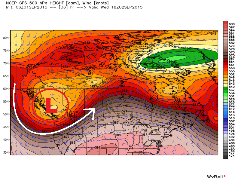
Gulf of Alaska Low
Here's a neat image that shows why temperatures across much of the nation are so warm (with the exception of the Pacific Northwest). A fairly large low pressure system in the Gulf of Alaska is helping to amplify a ridge of high pressure over the central part of the country with temperatures running well above average for most. This particular storm system will slowly move across Canada (in pieces) and help to cool things off a little across parts the nation over by next week.
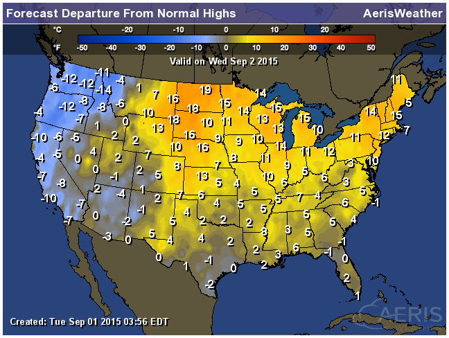
Highs From Average Wednesday
Daytime highs on Wednesday will be running anywhere from nearly 5° to 20° above average across the eastern two-thirds of the country. Meanwhile, note that readings west of the Rockies will be running a little cooler than average thanks to the area of low pressure/trough in the Gulf of Alaska mentioned above.
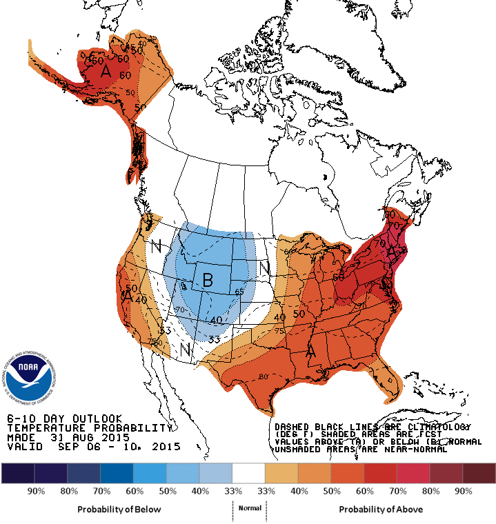
6 to 10 Day Temperature Outlook
According to NOAA's CPC, the big blob of warmer than average temperatures will continue in the eastern third of the nation into early next week, but the that pocket of cooler than average weather, which is currently along the West Coast, will begin to slide east by mid month. By the 2nd to 3rd week of September, it may feel a little more like fall for the central part of the country.
___________________________________
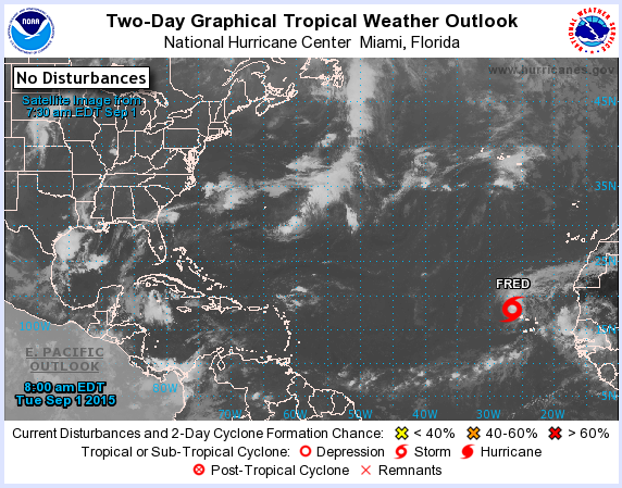
Peak of Atlantic Hurricane Season Nears...
According to NOAA, the peak of the Atlantic Hurricane Season is September 10th. Over the last 100 years, there have been more tropical systems on September 10th than on any other day during the season.

Tracking the Tropics
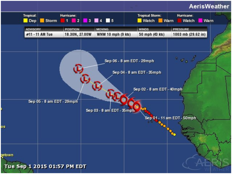
As we approach the peak of the Atlantic Hurricane Season, there is only 1 named system in the basin. As of Tuesday, Fred was still a Tropical Storm and was drifting WNW into away from the western tip of Africa.
Fred
This was Fred on Tuesday afternoon as it continued weaken just off the Cape Verde islands. By the way, did you know the Cape Verde Islands changed their name to the Cabo Islands in 2013? I will link a story below...
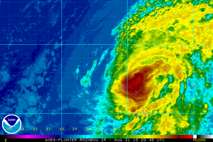
Tracking a Weakening Fred
Fred became our second Hurricane of the 2015 Atlantic Hurricane season for a fairly short amount of time. The track was northwest through the Cape Verde (Cabo Verde) Islands into less favorable weather conditions, so it weakened rather quickly.
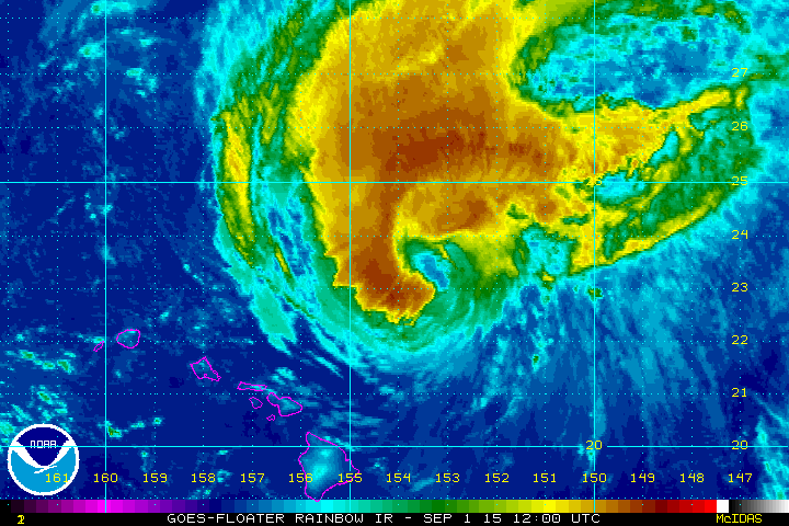
Active Pacific
This is an impressive sight, isn't it? The circulation of 3 different hurricanes ongoing in the Pacific Ocean. Interestingly, these were all category 4 storms at one point! Thankfully, the tracks have steered clear of the Hawaiian Islands!
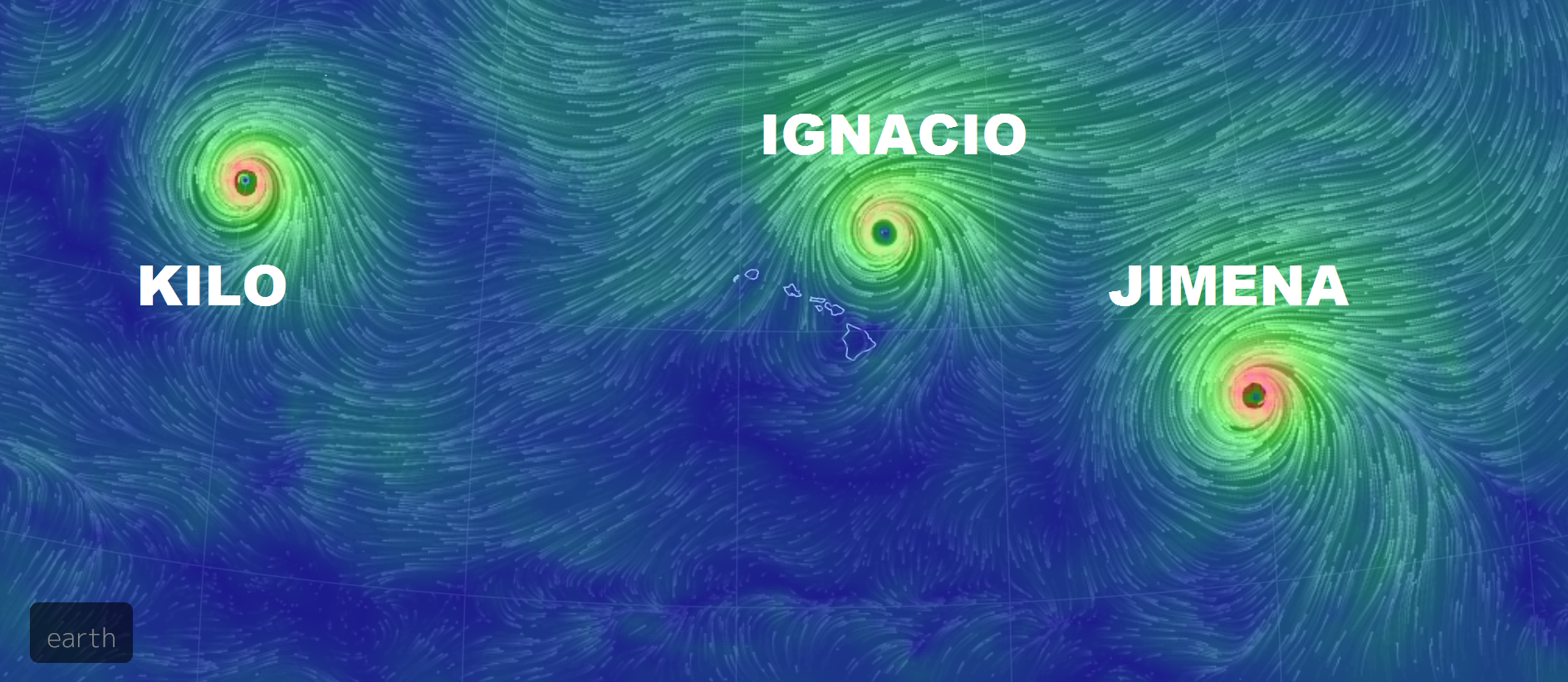
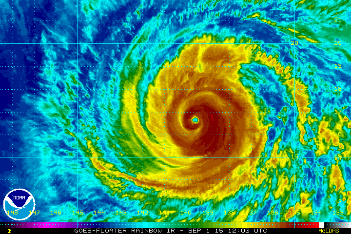
Kilo
As of Tuesday afternoon, Kilo was equivalent to a category 2 hurricane with sustained winds to near 104mph. At this point, Kilo poses not threat to any major landmass.
Ignacio
Thankfully, Ignacio drifted a little farther north than previous forecasts... It was definitely a close call. However, Ignacio will continue pushing north into the open waters of the Pacific Ocean and stay a fish storm.
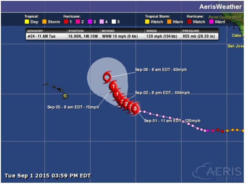
Tracking Ignacio
Note the pink colored dots when Ignacio was a Major Hurricane just east of Hawaii. I was getting nervous there for a moment that this thing was going to track right toward the Big Island. Thankfully it didn't!
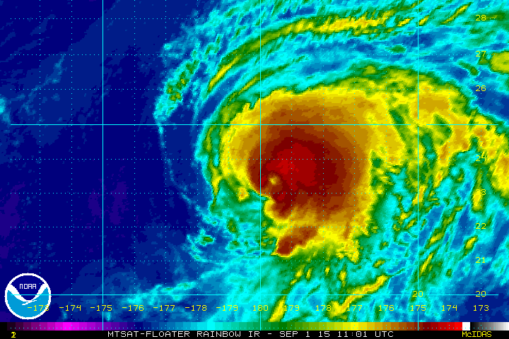
Jimena
Jimena was still a strong hurricane as of Tuesday afternoon with winds near 120mph. Unfortunately, this storm is still tracking toward Hawaii, but it appears it will continue turning north away from the islands through the rest of the week.
Tracking Jimena
It seems as if the Pacific Ocean is a tropical shooting gallery right now. I am praying that none of these tropical systems end up finding there way over the Islands! Jimena looks to continue tracking north away from Hawaii through the rest of the week.
_____________________________________________
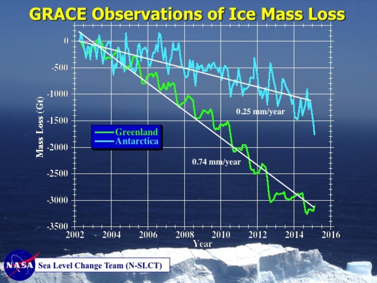
"Why NASA’s so worried that Greenland’s melting could speed up"
Here's an excerpt from an article by the WashingtonPost.com, which is a little concerning. An extensive research shows how much ice we've lost in Greenland and Antarctica since 2002. Note that the rate of ice loss is much more significant than that in Antarctica.
"NASA briefed the press on its “intensive research effort” into the rate and causes of sea level rise, releasing a suite of new graphics and visualizations showing how precisely the agency is measuring the upward creep of the oceans, currently at a rate of 3.21 millimeters per year. It would be easy to lose yourself in all of the new material, but if there’s one slide above all that really matters, it’s this one:"
See the full story from WashingtonPost.com HERE:
"NASA’s Gravity Recovery and Climate Experiment (GRACE) twin satellites have measured the loss of ice mass from Earth’s polar ice sheets since 2002. (Credit: Steve Nerem/CU-Boulder)"
__________________________________
Thanks for checking in and have a great rest of your week! Don't forget to follow me on Twitter @TNelsonWX

No comments:
Post a Comment