63 F. high in the Twin Cities Wednesday.
62 F. average high on October 7.
60 F. high on October 7, 2014.
October 8, 1949: A record-setting 3.17 inches of rain fell at Eau Claire.
 All or Nothing Weather Map
80F at MSP
on Sunday?
For
all the grief Minnesotans get about our winters we have precious little
to complain about in the weather department. I've unplugged my Doppler -
I'm swaying in my weather-hammock, waiting for an actual "storm" to
show up on the maps.
A story at
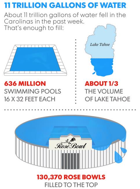
USA TODAY provides perspective on the sheer amount of rain that swamped the Carolinas earlier this week: 11 trillion
gallons of water, enough to fill 636 million swimming pools, or 130,370
Rose Bowl football stadiums to the top. Roughly the same amount of
water required to end the epic drought in California.
All or nothing. Weather whiplash on steroids. Where have you heard that before?
Rain slows the morning commute, but skies begin to clear later today. The stage is set for another glorious weekend: 70s
Saturday; a shot at 80F
on Sunday.
It's like we got to enjoy two Septembers in a row. Every day of
lukewarm breezes is a gift from on high - take nothing for granted.
We'll just have to be content with 60s next week; GFS guidance still hinting at a metro frost risk late next week.
El Nino warmth may take the edge off cold fronts into November.
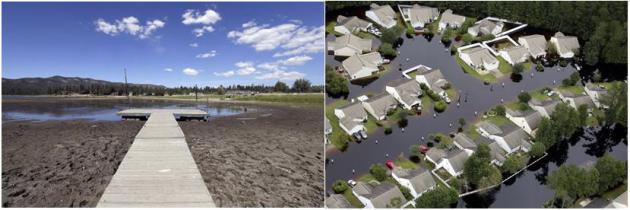
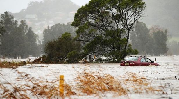
* California drought image: AP Photo/Nick Ut,File. South Carolina flood image: Janet Blackmon Morgan/The Sun News via AP.
11 Trillion Gallons of Water Fell on the Carolinas in the Past Week. Here's an excerpt of a mind-boggling article at
USA TODAY:
"...
The rain caused catastrophic flooding in North Carolina and South
Carolina, which received 5.2 trillion gallons and 5.8 trillion gallons,
respectively, according to data gathered by WeatherBell meteorologist Ryan Maue. He says 11 trillion gallons would be enough to fill:
- 636 million swimming pools (16 x 32 feet each)
- 130,370 Rose Bowls (filled to the top)
It's
also about one-third the volume of Lake Tahoe. And, amazingly, it's the
exact amount needed to end the drought in California, according to NASA
calculations in December. However, getting all 11 trillion gallons in a
few days wouldn't be the way to get it..."
A Slow-Motion Disaster is Underway in South Carolina Right Now. More jaw-dropping details via Andrew Freedman at
Mashable: "...
In
some areas of the state, so much rain fell between Oct. 1 and Oct. 4
that four all-time rainfall records were obliterated. Charleston even
set its record for the wettest October on record. 20-plus inches of rain that fell rank as an event more rare than a 1,000-year rainfall event,
according to the National Oceanic and Atmospheric Administration
(NOAA). A 90-mile stretch of Interstate 95 is still closed between
Interstates 20 and 26 due to flooding and overall poor road conditions..."
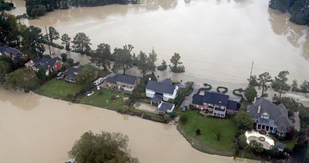
Photo credit above: "
Floodwaters close in on homes on a small piece of land on Lake Katherine in Columbia, S.C., Monday, Oct. 5, 2015." Image: Chuck Burton/Associated Press
"1000-Year" Flood: Hyperbole or Hard Science? CNBC takes a look at whether the 1-in-1,000 year figure really holds up; here's a clip: "...
The
estimates vary depending on whether or not a region typically sees a
lot of rain. A community prone to heavy flooding will have a lower
threshold, measured in inches of rainfall, for a 1,000-year event. The
threshold for a 1,000-year event in Charleston County, South Carolina over a three-day period is 17.1 inches. The recent flooding in South Carolina actually surpassed this figure. It is of such a high magnitude, (there's been more than 20 inches of rainfall in some areas
and the total rainfall has been calculated at 4.4 trillion gallons of
water), that its probability of occurring was less than a 10th of a
percent...."
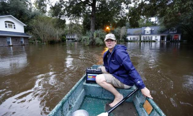
Photo credit above: "
Jeanni Adame
rides in her boat as she checks on neighbors seeing if they want to
evacuate in the Ashborough subdivision near Summerville, S.C., after
many of their neighbors left, Monday, Oct. 5, 2015. South Carolina is
still struggling with flood waters due to a slow moving storm system." (AP Photo/Mic Smith).
Climate Change is Turning 500-Year Floods into 24-Year Ones.
Smithsonian takes a look at how warmer air and oceans may be "juicing" the frequency and intensity of rain events; here's an excerpt: "...
People have long referred to the severity of floods in terms of their recurrence interval: the probability that a flood might reach a certain level within a certain number of years. Now, writes Tim Darragh for NJ.com,
those designations are getting even more confusing — and more dire — as
scientists warn that residents of the Atlantic coast could witness
storms with the magnitude of what were once “500-year floods” every 24
years. New research
shows that flood risks in New York City and along the Atlantic coast
has “increased significantly” during the past millennium. The change is
due to a combination of rising sea levels and an increase in the kinds
of storms that produce widespread flooding..."
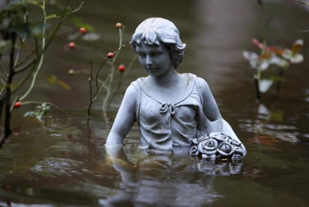
Photo credit above: "
A
statue in flood waters in the Ashborough subdivision near Summerville,
S.C., Monday, Oct. 5, 2015. South Carolina is still struggling with
flood waters due to a slow moving storm system." (AP Photo/Mic Smith).
 What The European Model "Win" Means for Weather Forecasting
.
No weather model is infallible, but the ECMWF seems to - fairly
consistently - do a better job with the tracks of tropical systems. Even
so, as highlighted in a good article at
The Washington Post's Capital Weather Gang by Jason Samenow, the GFS has had its moments: "...
There
have been notable recent cases in which the GFS model provided a better
forecast. For example, in 2012, the GFS model offered a more accurate
track forecast for Hurricane Isaac which tracked through the Gulf of
Mexico. The GFS model also provided a better forecast last January when
New York City city was supposed to be buried under more than two feet of
snow according to the European model. In reality, only eight inches
fell, closer to the GFS model forecast..."
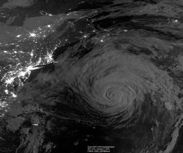
Image credit above: "
Hurricane Joaquin." (Cooperative Institute for Meteorological Satellite Studies at the University of Wisconsin-Madison).
People May Risk Living in Disaster Zone if They Think Threat is Once-In-A-Lifetime Event. Australia's ABC Network has a curious article focused on new research results; here's an excerpt: "
Humans
may be willing to put daily pleasure ahead of the threat of long-term
disaster when selecting where to live, a new international study
suggests. Study co-author Professor Ben Newell, of the University of
NSW, said the research examined how people would react to being told of a
predicted increase in the risk of natural disasters with climate
change. Professor Newell, from the School of Psychology, said it was
surprising how little weight participants in the study gave to disaster
threat..." (Image: Conan Whitehouse).
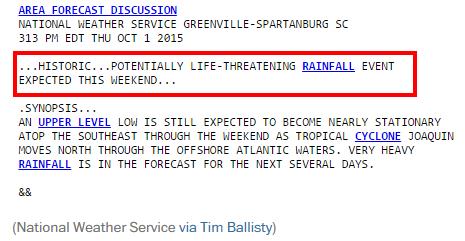
Meteorologists Pegged the Epic South Carolina Flood Forecast Days in Advance.
The hurricane track forecast left something to be desired, but overall
NOAA and local forecasters did a good job focusing in on South Carolina,
as reported by
The Capital Weather Gang: "...
On
Thursday afternoon, the National Weather Service forecast office
serving western South Carolina wrote: “Historic…Potentially
life-threatening rainfall event expected this weekend.” It added, “Storm total quantitative precipitation forecast … is over 10 inches...”
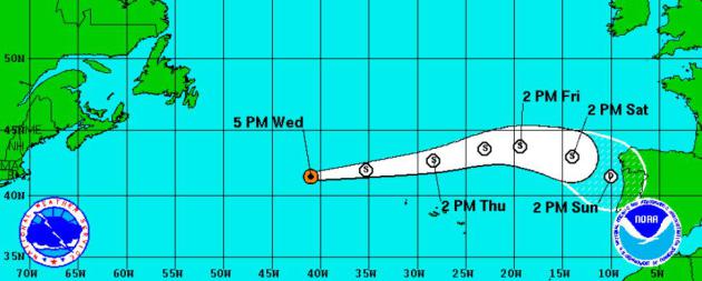
Tropical Storm Threatens....Portugal?
Here's the latest NOAA NHC track of tropical storm, forecast to weaken
into a depression before brushing Portugal and Spain by Saturday. Yes,
that's a bit odd, but not unprecedented.
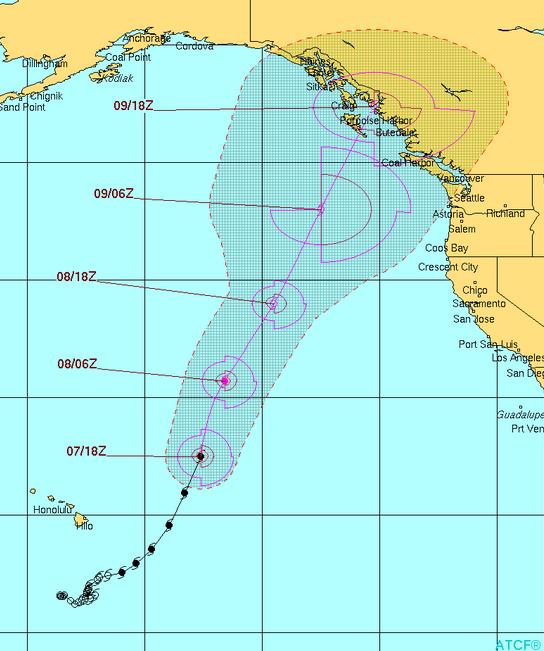
Tropical Storm Strike...in British Columbia?
Another symptom of unusually warm water, the much advertised "blob" in
the eastern Pacific? Hurricane Oho is forecast to weaken to tropical
storm status, but a direct strike on B.C. can't be ruled out by Friday.
When tropical storms routinely hit Alaska we'll know the pattern really
has shifted. Graphic:
Joint Typhoon Warning Center.
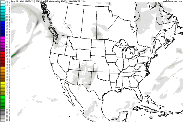
84-Hour Rainfall.
You can see the plume of moisture from Tropical Storm Oho pushing
toward British Columbia by late week; relatively dry weather forecast
for the Carolinas, where recovery and clean-up efforts continue from
historic flooding. With the exception of showers this morning it's still
a fairly dry, drama-free pattern for Minnesota and the Upper Midwest.
Loop: NOAA and AerisWeather.
70s into Late October?
I keep pinching myself (although not in public) - reminding myself that
we're in October. But the maps still look like early September, with a
mild bias possibly lingering into the end of the month (or beyond).
NOAA's GFS model has more 70s the third week of October. Considering we
could be anke-deep in snow I'm giving thanks. El Nino? Global warming?
The mild blob in the Pacific? Attribution is difficult, but whatever the
trigger our slow-motion limp into autumn continues.
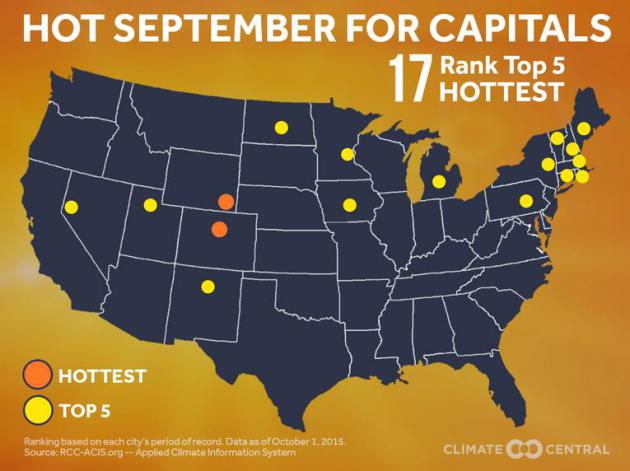
State Capitals: Hot Septembers.
Statewide, Minnesota was roughly 6F warmer than average, possibly the
warmest September on record for Minnesota. Here's an excerpt from
Climate Central: "...
A
sampling of state capitals reveals that 17 of the 50 capitals had one
of their 5 hottest Septembers on record. Two of these (Cheyenne and
Denver) had their hottest September on record. Globally, 2015 is the
hottest year on record so far – and it’s been running that way nearly
all year. Nationally, we’re on pace to be one of the top 10 hottest
years...."
Pet Dust Devil. Check out this nearly stationary dust devil, videotaped in China. Odd to see it nearly stationary. Video courtesy of
MSN.
Wind and Solar Keep Getting Cheaper and Cheaper.
Good 'ol Moore's Law. Prices will continue to drop, helping renewables
scale faster that the professional critics thought possible. Here's an
excerpt from
The Washington Post: "
A
new analysis suggests that we continue to move into a world in which it
makes more economic sense to draw electricity from the sun or the
winds, rather than from fossil fuels. The report, from Bloomberg New
Energy Finance, examined the “levelized cost of electricity” around the
world in the second half of 2015 — a metric that seeks to take a
comprehensive look at costs including capital expenditures, interest
rates and operating costs. It’s an approach that is able to “put
technologies on a level playing field and enable that comparison, which
is valuable,” says Seb Henbest, head of Europe, Middle East, and Africa
analysis for Bloomberg New Energy Finance..." (credit: Shutterstock).
Wind and Solar Boost Cost Competitiveness versus Fossil Fuels.
Bloomberg New Energy Finance has the details; here's an excerpt: "
This
year has brought a significant shift in the generating cost comparison
between renewable energy and fossil fuels, according to detailed
analysis by technology and region, published this week by Bloomberg New
Energy Finance. The research company’s Levelised Cost of Electricity
Update for the second half of 2015, based on thousands of data points
related to individual deals and projects around the world, shows that
onshore wind and crystalline silicon photovoltaics – the two most
widespread renewable technologies – have both reduced costs this year,
while costs have gone up for gas-fired and coal-fired generation..." (credit: Fresh Energy).
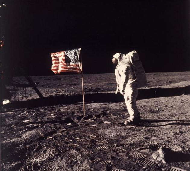
Opinion: Our Generation's Moon-Shot: A Clean-Energy World by 2050.
Can it be done? We have the technology and the entrepreneurs - what's
been lacking is political will, especially in Washington D.C. Here's the
intro to an Op-Ed at
MarketWatch: "
In May 1961, President John F. Kennedy stirred America and the world with
these words: “I believe that this nation should commit itself to
achieving the goal, before this decade is out, of landing a man on the
moon and returning him safely to the Earth.” Just eight years later,
NASA did just that — with astounding benefits for science, technology,
and the world economy. Now, a group of leading scientists, innovators,
and economists has identified our era’s moonshot: to replace fossil
fuels with clean-energy technologies within this generation..."
File photo credit above: "
In
this July 20, 1969 file photo, astronaut Edwin E. "Buzz" Aldrin Jr.
stands next to a U.S. flag planted on the moon during the Apollo 11
mission. Aldrin and Neil Armstrong were the first men to walk on the
lunar surface. During a ceremony in Melbourne, Fla. on Thursday, Aug.
27, 2015, Aldrin announced he is teaming up with the Florida Institute
of Technology to develop "a master plan" for colonizing Mars within 25
years." (Neil A. Armstrong/NASA via AP)
Xcel Energy Plans to Retire 2 of 3 Coal-Fired Sherco Units. Details via
The Star Tribune; here's a clip: "
Xcel
Energy announced plans Friday to retire two of the three units at its
huge Sherco coal-fired power plant in Becker, the largest power plant in
Minnesota, as part of a strategy to cut its carbon emissions 60 percent
by 2030. Sherco's two oldest units would shut down in 2023 and 2026.
Other components of the proposal filed Friday with the Minnesota Public
Utilities Commission include more wind and solar energy so that in five
years, 28 percent of Xcel's energy mix could come from renewable
sources, rising to 35 percent by 2030. And the company said its upper
Midwest system would deliver 63 percent carbon-free energy by 2030..."
TODAY: Rain early, slow PM clearing. Winds: NW 10-20. High: 65
THURSDAY NIGHT: Partly cloudy and cooler. Low: 47
FRIDAY: Sunny, less wind. Winds: NW 8-13. High: 61
SATURDAY: Sunny, gusty winds. Winds: SW 15-25. Wake-up: 46. High: 71
SUNDAY: What October? Warm sunshine. Winds: SW 10-15. Wake-up: 57. High: 80
MONDAY: Cloudier, passing shower? Wake-up: 59. High: 63
TUESDAY: Mix of clouds and sun. Wake-up: 49. High: 67
WEDNESDAY: Patchy clouds. Wake-up: 52. High: 66
Climate Stories...
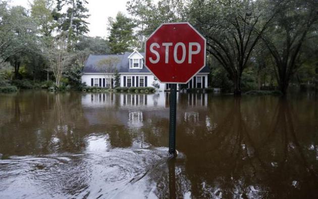
Climate Change Intensified South Carolina Floods.
Would the storm have happened otherwise? Absolutely. Did a (much)
warmer than average Atlantic ocean coupled with more water vapor than
usual floating overhead spike, or "juice" the storm? It appears that's
the case. Here's an excerpt from
Climate Central: "...
Mann
said hurricane Joaquin intensified in the tropical Atlantic, which is
experiencing record sea-surface temperatures. These temperatures helped
the hurricane strengthen quickly and unusually warm, wet air fed it even
more. That moisture turned into the record rainfall which fell on the
Carolinas. “In this case, we’re seeing once-in-a-thousand year flooding
along the South Carolina coastline
as a consequence of the extreme supply of moisture streaming in from
hurricane Joaquin,” Mann said. The “once-in-a-thousand” phrase does not
mean the storm occurs once every 1,000 years, but rather that there is a
0.1% chance of such an intense storm occurring in any year..."
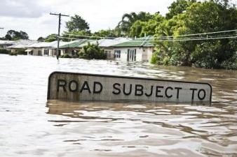
Photo credit above: "
A
stop sign in flood waters in the Ashborough subdivision near
Summerville, S.C., Monday, Oct. 5, 2015. South Carolina is still
struggling with flood waters due to a slow moving storm system." (AP Photo/Mic Smith)
Stuff Happens to the Environment, Like Climate Change. Tom Friedman, the pride of St. Louis Park, has an Op-Ed at
The New York Times; here's an excerpt: "...
There
was a time when we could tolerate this kind of dumb-as-we-wanna-be
thinking. But it’s over. The next eight years will be critical for the
world’s climate and ecosystems, and if you vote for a climate skeptic
for president, you’d better talk to your kids first, because you will
have to answer to them later. If you have time to read one book on this
subject, I highly recommend the new “Big World, Small Planet,”
by Johan Rockstrom, director of the Stockholm Resilience Center, and
Mattias Klum, whose stunning photographs of ecosystem disruptions
reinforce the urgency of the moment..."
An Inconvenient Truth for Florida.
Lawmakers in the Sunshine State are still in a state of denial, and
that will probably come back to haunt them in the years to come. Here's
an excerpt of an Op-Ed at
gainesville.com: "...
Yet
as noted at the conference, state lawmakers have passed on large-scale
mitigation efforts to prevent seawater from infiltrating the freshwater
aquifer that supplies drinking water. The state is also keeping
residents from taking steps to cut the carbon emissions that contribute
to climate change. Florida is ranked third in its potential to produce
solar energy yet is just one of four states that limit electric sales to
utilities, according to the Herald. Florida’s major utilities have
gutted solar rebate programs and energy-efficiency goals, and now are
fighting an initiative that would create solar competition for them..."
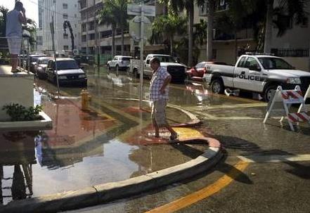
Photo credit above: "
A man walks the flooded sidewalk along Indian Creek Drive in Miami Beach on Sept. 28." Mily Michot/The Miami Herald via AP.
Disaster Resilience Key to Managing Climate Change, Say Insurers.
The insurance industry is sitting up and paying attention to the
trends. Climate disruption is already hitting them (and their clients)
in their wallets. Here's an excerpt from
The Sydney Morning Herald that got my attention: "...
Mr
Carney pointed out that the number of weather-related loss events has
tripled since the 1980s. Inflation-adjusted insurance losses from these
events had increased from an annual average of about $10 billion then to
about $50 billion over the past decade. "While there is still time to
act, the window of opportunity is finite and shrinking," he warned..."
Photo credit above: "
The
number of weather-related loss events has tripled since the 1980s.
Inflation-adjusted insurance losses from these events have increased
from an annual average of about $10 billion then to about $50 billion
over the past decade."
Photo: Mark Nolan
What The Historic South Carolina Floods Can - and Can't - Tell Us About Climate Change. Here's a snippet of additional perspective from
The Washington Post: "...
Thus, you
can certainly say for the South Carolina floods — as you can for the
2013 Boulder, Colo., floods, and the Texas and Oklahoma floods earlier
this year — that they are consistent with what we would expect in a
warming world. “As the world warms, more water evaporates from the
ocean, as well as lakes and rivers,” says Katharine Hayhoe, a climate
scientist from Texas Tech University. “That means that, when a hurricane
or a storm system comes along, there is on average more water vapor
available for it to pick up and dump on us than there would have been 50
or 100 years ago...”
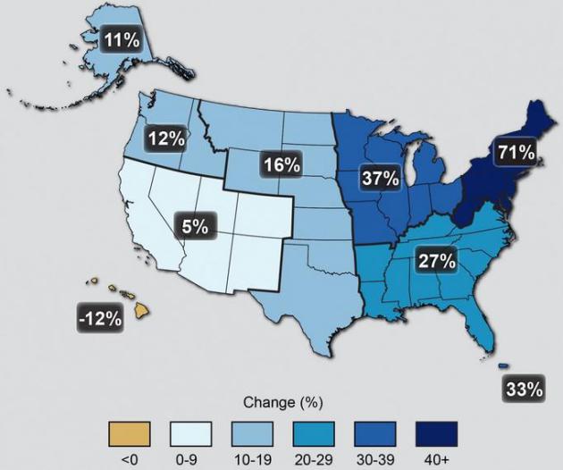
Map credit above: "
The
map shows percent increases in the amount of precipitation falling in
very heavy events (defined as the heaviest 1% of all daily events) from
1958 to 2012 for each region of the continental United States." Source: U.S. National Climate Assessment
Wells Fargo Statement on Climate Change. Full disclosure: I am a Wells Fargo client, and my business provides services for Wells Fargo. Here is an excerpt
recent statement from Wells Fargo: "..
.We
join with the growing number of businesses, customers, and communities
in expressing our view that we all need to do our part to find solutions
to the climate change challenge. Specifically, we believe
non-governmental organizations (NGOs) must continue to work
constructively and collaboratively with private and public sectors to
develop viable climate solutions; and governments need to establish
clear climate change policy frameworks thta provide the market with the
certainty it needs to increase investment in low-carbon solutions and
innovation..."
Citigroup, Citing Climate Change, Will Reduce Coal Financing. Here's an excerpt from a story at
Bloomberg Business: "
Citigroup
Inc., the third-biggest U.S. bank, said it will cut back on financing
for coal mining projects, in the latest blow to the industry that’s
viewed as a key contributor to global warming. Citigroup said its credit
exposure to coal mining had “declined materially" since 2011 and that
the trend would continue into the future. The policy applies to
companies that use mountaintop removal methods as well as coal-focused
subsidiaries of diversified mining companies, according to the New
York-based company’s Environmental & Social Policy Framework guidelines posted online Monday..."


No comments:
Post a Comment