69 F. high in the Twin Cities Tuesday.
63 F. average high on October 6.
63 F. high on October 6, 2014.
October 7, 2003:
Record high temperatures were seen across the area. St. Cloud's high
was 86 degrees Fahrenheit. Minneapolis tied their record of 85 degrees
set in 1997, and Alexandria set their record with 88 degrees. Forest
Lake reached a record-setting 82 degrees, along with Stillwater at 84
degrees.
October 7, 1980: Summer-like heat over Minnesota with 92 at Montevideo and 84 at the Twin Cities.
A Fine October: More 70s Brewing for The Weekend"There
was something horribly depressing, she felt, about watching the weather
report. That life could be planned like the perfect summer picnic
drained it of spontaneity” wrote Galt Niederhoffer.
I'm a big
fan of spontaneity; there's far too little of it in my life. I'm a slave
to my calendar and to-do list. We schedule and plan, but sometimes the
weather gets in the way.
My oldest son is getting married at the
end of the month up on Gull Lake. I'm hoping for the best. It could be
60F or snowing - or anything in-between. The accuracy of a 2 week
forecast for a precise location is close to 50-50; the rough equivalent
of a coin-flip. Honey, in the unlikely event you're reading this the
forecast is "changeable".
Ask me in November.
Exhibit A: 4 years ago today the high was 85. In 2002 it snowed at MSP on October 7. Yes, October can be a
manic month, but I still don't see any weather drama. Showers brush the state late
Wednesday into early
Thursday, but weekend highs surge well into the 70s. Long-range guidance hints at a frost risk late next week.
It's too quiet. I'm waiting for the other shoe (or boot) to drop.
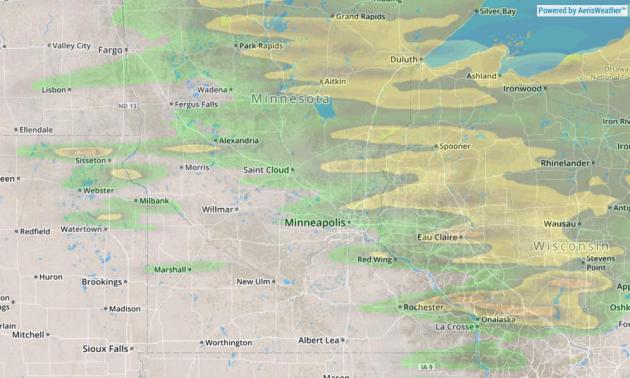
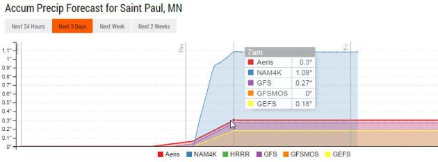
Rainfall Accumulations.
NOAA's NAM model shows the best chance of rain coming north and east of
MSP from a clipper-like system tonight and early Thursday. Source:
Aeris Enterprise.
How Much Rain?
Probably not much for the metro, although the 4 KM NAM model tries to
print out an inch of rain tonight and Thursday morning. I suspect it
will be closer to .1 to .3", if that.
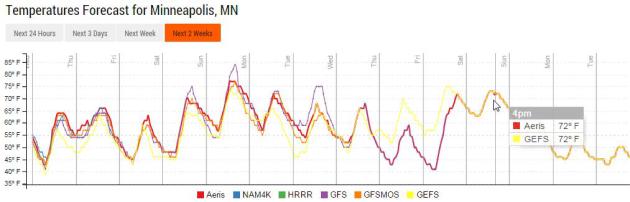
70+ A Week from Saturday?
I certainly wouldn't take this to the bank - but models hint at
70-degree temperatures October 16-17 in the metro area. Circle your
calendars - our long, luxurious, vaguely unsettling autumn continues.
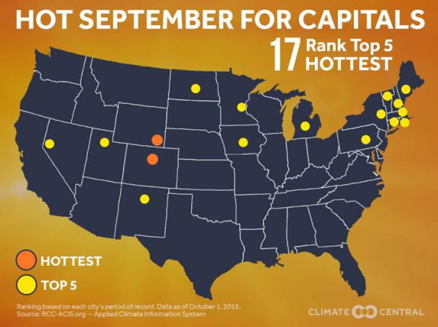
State Capitals: Hot Septembers.
Statewide, Minnesota was roughly 6F warmer than average, possibly the
warmest September on record for Minnesota. Here's an excerpt from
Climate Central: "...
A
sampling of state capitals reveals that 17 of the 50 capitals had one
of their 5 hottest Septembers on record. Two of these (Cheyenne and
Denver) had their hottest September on record. Globally, 2015 is the
hottest year on record so far – and it’s been running that way nearly
all year. Nationally, we’re on pace to be one of the top 10 hottest
years...."
 What The European Model "Win" Means for Weather Forecasting
.
No weather model is infallible, but the ECMWF seems to - fairly
consistently - do a better job with the tracks of tropical systems. Even
so, as highlighted in a good article at
The Washington Post's Capital Weather Gang by Jason Samenow, the GFS has had its moments: "...
There
have been notable recent cases in which the GFS model provided a better
forecast. For example, in 2012, the GFS model offered a more accurate
track forecast for Hurricane Isaac which tracked through the Gulf of
Mexico. The GFS model also provided a better forecast last January when
New York City city was supposed to be buried under more than two feet of
snow according to the European model. In reality, only eight inches
fell, closer to the GFS model forecast..."
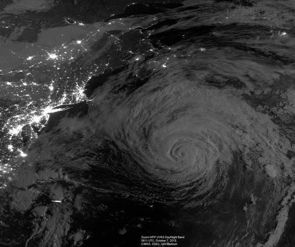
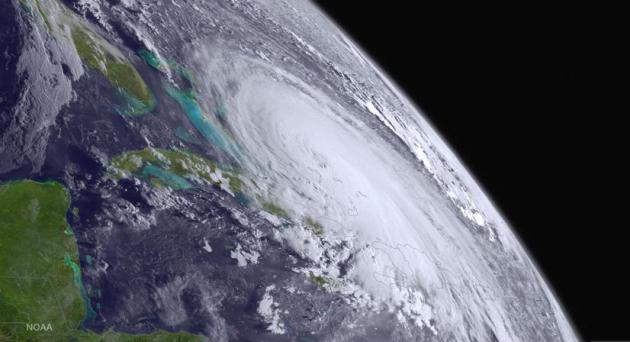
Image credit above: "
Hurricane Joaquin." (Cooperative Institute for Meteorological Satellite Studies at the University of Wisconsin-Madison.)
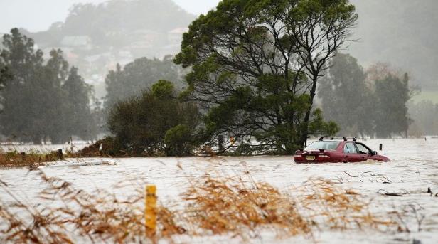
Dam Danger: South Carolina Crews Checking Flood Levels "Minute by Minute". Here's a snippet of an update on the ongoing danger in South Carolina from
Fox News: "
Officials
across South Carolina were monitoring the state's historic flood levels
"minute by minute" Tuesday, according to Gov. Nikki Haley, as crews
work to protect several dams from potentially catastrophic breaches.
More than a dozen dams have burst across the state. Some of the breaches
forced officials to evacuate neighborhoods east of Columbia from the
rushing water. A solid week of rainfall has sent nearly 1,000 people to
shelters, and left about 40,000 without drinkable water..."
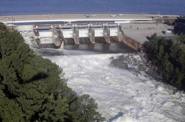
Photo credit above: "
Water
pours from a gate in the Lake Murray dam in Columbia, S.C., Tuesday,
Oct. 6, 2015. Despite an improving forecast, it will still take weeks
for the state to return to normal after being pummeled by a historic
rainstorm." (AP Photo/Chuck Burton)
"1000-Year" Flood: Hyperbole or Hard Science? CNBC takes a look at whether the 1-in-1,000 year figure really holds up; here's a clip: "...
The
estimates vary depending on whether or not a region typically sees a
lot of rain. A community prone to heavy flooding will have a lower
threshold, measured in inches of rainfall, for a 1,000-year event. The
threshold for a 1,000-year event in Charleston County, South Carolina over a three-day period is 17.1 inches. The recent flooding in South Carolina actually surpassed this figure. It is of such a high magnitude, (there's been more than 20 inches of rainfall in some areas
and the total rainfall has been calculated at 4.4 trillion gallons of
water), that its probability of occurring was less than a 10th of a
percent...."
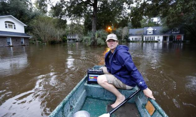
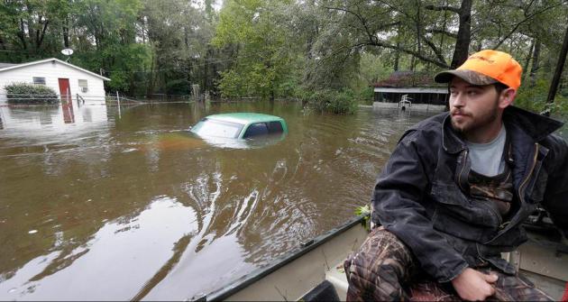
Photo credit above: "
Jeanni Adame
rides in her boat as she checks on neighbors seeing if they want to
evacuate in the Ashborough subdivision near Summerville, S.C., after
many of their neighbors left, Monday, Oct. 5, 2015. South Carolina is
still struggling with flood waters due to a slow moving storm system." (AP Photo/Mic Smith).
Forecasting Hurricane Joaquin and Other Storms is Hard.
How Do Scientists Do It? No kidding. Here's an excerpt from a story at
CNN: "...
Adding
to the challenge for scientists is climate change. Because hurricanes
are powered by the heat in the ocean, researchers concede it's growing
more difficult to predict where or when storms will pop up and
strengthen. Haus points to another issue. "I think what is clear for
coastal areas is that sea levels are rising. There's no way we're going
to get around that," he said. "So the risk that coastal communities are
facing is just going to be getting higher and higher, particularly in
low-lying areas -- Miami, Tampa, Houston, Washington D.C., the
Northeast. These areas, like you saw with Sandy, are very vulnerable..." (Image credit: NOAA).
The Meteorology Behind South Carolina's Catastrophic 1,000-Year Rainfall Event. Here's excellent perspective from
The Capital Weather Gang at the Washington Post; an excerpt: "...
As
Hurricane Joaquin tracked north, well east of the coast,
a separate, non-tropical low pressure system was setting up shop over
the Southeast late last week. This system drew in a deep, tropical plume
of water vapor off the tropical Atlantic Ocean. At the same time, this
upper-level low pressure system tapped into the moist outflow of
Hurricane Joaquin. The moisture pipeline fed directly into a pocket of
intense uplift on the northern side of the non-tropical vortex. Within
this dynamic “sweet spot,” thunderstorms established a training
pattern, passing repeatedly over the same location and creating a narrow
corridor of torrential rain stretching from Charleston to the southern
Appalachians..."
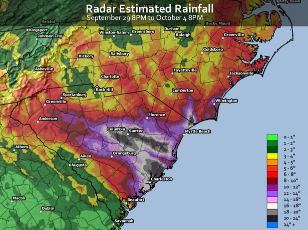
Map credit above: "
A
preliminary map of rainfall totals, estimated from radar, shows the
vast extent of the deluge across most of South Carolina and parts of
coastal North Carolina. The National Weather Service notes that these
radar estimates have likely under-estimated the regional rainfall totals
by a factor of 30 to even 50 percent in some locations." (Jordan Tessler/Capital Weather Gang)
What Does a "100 or 1000-Year Rain Event" Really Mean? Marshall Shepherd does a good job breaking this down at
Forbes; here's an excerpt: "...
However,
as I watch the media and social media, it is apparent to me that many
people still do not understand the concept of what 100- or 1000-Year
rain event means. Many people literally assume it means this event “can
only” happen every 1000 years (in the case of a 1000-year event). Here
is what it actually means as described on the NOAA National Center for Environmental Information (NCEI, but formerly NCDC) webpage:
…it
is a statistical way of expressing the probability of something
happening in any given year. A “100 year” storm event has a one in one
hundred or 1% chance of happening in any given year. A “500 year” event
has a one in five hundred or .2% chance of happening in any year..."
 South Carolina Flood is 6th, 1000-Year Rain since 2010
. Doyle Rose has the story at
USA TODAY; here's the introduction: "
The
biblical flooding in South Carolina is at least the sixth
so-called 1-in-1,000 year rain event in the U.S. since 2010, a
trend that may be linked to factors ranging from the natural, such as a
strong El Niño, to the man-made, namely climate change. So many
"1-in-1,000 year" rainfalls is unprecedented, said meteorologist Steve
Bowen of Aon Benfield, a global reinsurance firm. "We have certainly had
our fair share in the United States in recent years, and any increasing
trend in these type of rainfall events is highly concerning," Bowen
said..." (File photo: USGS).
Climate Change is Turning 500-Year Floods into 24-Year Ones.
Smithsonian takes a look at how warmer air and oceans may be "juicing" the frequency and intensity of rain events; here's an excerpt: "...
People have long referred to the severity of floods in terms of their recurrence interval: the probability that a flood might reach a certain level within a certain number of years. Now, writes Tim Darragh for NJ.com,
those designations are getting even more confusing — and more dire — as
scientists warn that residents of the Atlantic coast could witness
storms with the magnitude of what were once “500-year floods” every 24
years. New research
shows that flood risks in New York City and along the Atlantic coast
has “increased significantly” during the past millennium. The change is
due to a combination of rising sea levels and an increase in the kinds
of storms that produce widespread flooding..."
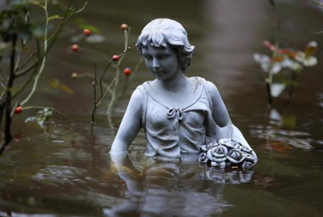
Photo credit above: "
A
statue in flood waters in the Ashborough subdivision near Summerville,
S.C., Monday, Oct. 5, 2015. South Carolina is still struggling with
flood waters due to a slow moving storm system." (AP Photo/Mic Smith)
Climate of Doubt.
While record floodwaters paralyze much of the Carolinas Californians
are becoming increasingly desparate - some turning to dowsers to find
water. Here's an excerpt of an article at
Aeon: "...
Of
course, there are people who doubt Hope’s abilities. According to the
United States Geological Survey: ‘The natural explanation of
“successful” water dowsing is that in many areas water would be hard to
miss.’ But the state is now entering its fourth year without enough
rain, and this summer struggling farmers will let 620,000 acres lie
fallow, losing an estimated $5.7 billion dollars. As increasingly
desperate Californians turn to dubious and expensive long-term projects
like piping water 1,400 miles from Alaska or building a billion‑dollar
desalination plant in San Diego, dowsing for a well looks downright
sensible..."
Photo credit above: "
Dowser King Faria, a former dairy farmer, during a drought in Marin County, California. February 2nd, 1977". Photo by Bettmann/Corbis.
Not What I Ordered: How El Nino Is Like a Bad Bartender.
Great analogy. Or maybe a good bartender with a very bad memory. Bottom
line: it's dangerous to generalize; every El Nino is different. Here's a
clip from a good post at
NOAA's climate.gov: "...
If
you’ve been following along over at The ENSO Blog, you know this El
Niño event is already one of the big ones. And, it will very likely take
its place among the pantheon of El Niños of the last 60-70 years. But
the expectations in some places aren’t as cut and dried as you might
think. Let’s say you have a favorite establishment, where everybody
knows your name, and they bring you “your” beverage on sight. And then
one night you go in, and based upon your past experience, you sorta
expect the bartender to bring you your favorite beer. Instead, maybe he
unexpectedly brings you a warmer-than-normal beer, or even
a wine cooler. El Niño is like that bartender. Seeing
him when you walk in may tilt your odds toward getting your favorite
beer, but it’s not a guarantee. In other words, sometimes El Niño is the
bartender who doesn’t bring you what you ordered..."
No, You're Not Imagining It - The Fall Weather Really Can Trigger Migraines. Many of us are walking, talking barometers - here's a clip from a story at
Yahoo Health: "...
It’s true: Seasonal changes really can provoke migraines — those severe, throbbing headaches that are often accompanied by auras, nausea, and sensitivity to light and sound. In fact, research suggests that weather is a trigger
for around half of migraineurs who are aware of their triggers. While
it’s clear that outside ambience can cause head pain, figuring out what
it is about the change in season that is the culprit is harder to do,
says Lee Peterlin, DO, associate professor of neurology and director of
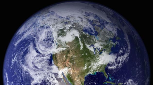
headache research at the Johns Hopkins University School of Medicine..." (Image: NASA Earth Observatory).
Tim Cook's Apple Has Forced the Whole Tech World to Realign.
Now that we're all walking around with shiny supercomputers in our
pockets and purses the world really has changed, opening up new
opportunities for business. Here's an excerpt from
WIRED: "...
The
theme of the Box conference was mobile technology, and Cook asserted
that businesses still have only a halting grasp of mobile’s potential.
At the moment, he claimed, most businesses think of mobile tech as
little more than a portable way to check email. “To take advantage of it
in a huge way you have to rethink everything that you’re doing,” he
said. “There’s no doubt in my mind the best companies will be the most
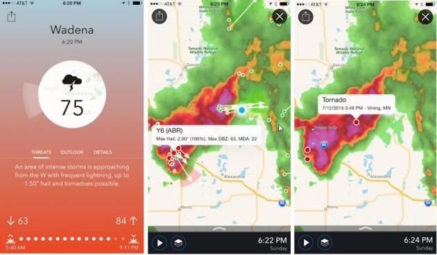
mobile....” (Image: AerisWeather).
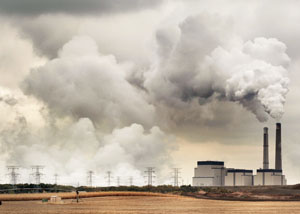
Xcel Energy Plans to Retire 2 of 3 Coal-Fired Sherco Units. Details via
The Star Tribune; here's a clip: "
Xcel
Energy announced plans Friday to retire two of the three units at its
huge Sherco coal-fired power plant in Becker, the largest power plant in
Minnesota, as part of a strategy to cut its carbon emissions 60 percent
by 2030. Sherco's two oldest units would shut down in 2023 and 2026.
Other components of the proposal filed Friday with the Minnesota Public
Utilities Commission include more wind and solar energy so that in five
years, 28 percent of Xcel's energy mix could come from renewable
sources, rising to 35 percent by 2030. And the company said its upper
Midwest system would deliver 63 percent carbon-free energy by 2030..."
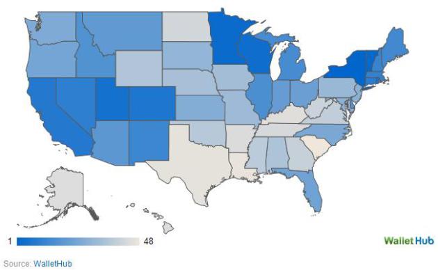
How Energy Efficient Is Your State? Minnesota is #3! Wisconsin is #4!
US News has the story; here's the introduction: "
The
Empire State is also America's most energy-efficient. New York tops a
new list of the most efficient U.S. states in 2015 based on home- and
car-energy consumption, followed by Vermont, Minnesota, Wisconsin and
Utah. Warm-weather states rounded out the bottom of the list – compiled by the personal finance site WalletHub –
with South Carolina finishing last, preceded by Louisiana, Texas,
Kentucky and Arkansas. (Alaska and Hawaii were not counted due to "data
limitations.")..."
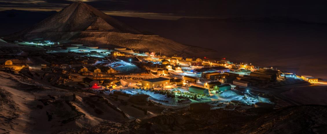
Scientists in Antarctica Drink a Lot. Maybe Too Much. You could sort of see this coming -
WIRED reports; here's a clip: "...
So to stay sane, many scientists, technicians, cooks and drivers at the main US bases—McMurdo Station and the South Pole—employ
the social lubricant of alcohol to decompress. But as the austral
summer research season gets underway this month, a new teetotaling
mandate from Washington may dampen the spirits of the tight-knit
Antarctic community. And to enforce it, the National Science Foundation
is thinking about deploying breathalyzers to the driest, coldest,
weirdest continent..."
Photo credit above: "
McMurdo
Station on Ross Island experiences 24 hours of darkness in the middle
of winter. The lights from the largest research station in Antarctica
illuminate Observation Hill just to the south of town."
Joshua Swanson/NSF.
TODAY: Sun fades as clouds increase. Winds: SE 5-10. High: 66
WEDNESDAY NIGHT: Cloudy with a chance of showers, heaviest north. Low: 60
THURSDAY: Showers taper, drier PM hours. Winds: NW 10-15. High: 67
FRIDAY: Sunny and pleasant. Wake-up: 48. High: 62
SATURDAY: Lukewarm sun, windy. Winds: SW 15-25. Wake-up: 47. High: 72
SUNDAY: What October? Warm sun. Winds: SW 10-15. Wake-up: 57. High: near 80
MONDAY: Windy, turning cooler with lingering clouds. Wake-up: 59. High: 66
TUESDAY: Mix of clouds and sun. Wake-up: 50. High: 65
Climate Stories...
Wells Fargo Statement on Climate Change. Full disclosure: I am a Wells Fargo client, and my business provides services for Wells Fargo. Here is an excerpt
recent statement from Wells Fargo: "..
.We
join with the growing number of businesses, customers, and communities
in expressing our view that we all need to do our part to find solutions
to the climate change challenge. Specifically, we believe
non-governmental organizations (NGOs) must continue to work
constructively and collaboratively with private and public sectors to
develop viable climate solutions; and governments need to establish
clear climate change policy frameworks thta provide the market with the
certainty it needs to increase investment in low-carbon solutions and
innovation..."
Citigroup, Citing Climate Change, Will Reduce Coal Financing. Here's an excerpt from a story at
Bloomberg Business: "
Citigroup
Inc., the third-biggest U.S. bank, said it will cut back on financing
for coal mining projects, in the latest blow to the industry that’s
viewed as a key contributor to global warming. Citigroup said its credit
exposure to coal mining had “declined materially" since 2011 and that
the trend would continue into the future. The policy applies to
companies that use mountaintop removal methods as well as coal-focused
subsidiaries of diversified mining companies, according to the New
York-based company’s Environmental & Social Policy Framework guidelines posted online Monday..."
Disaster Resilience Key to Managing Climate Change, Say Insurers.
The insurance industry is sitting up and paying attention to the
trends. Climate disruption is already hitting them (and their clients)
in their wallets. Here's an excerpt from
The Sydney Morning Herald that got my attention: "...
Mr
Carney pointed out that the number of weather-related loss events has
tripled since the 1980s. Inflation-adjusted insurance losses from these
events had increased from an annual average of about $10 billion then to
about $50 billion over the past decade. "While there is still time to
act, the window of opportunity is finite and shrinking," he warned..."
Photo credit above: "
The
number of weather-related loss events has tripled since the 1980s.
Inflation-adjusted insurance losses from these events have increased
from an annual average of about $10 billion then to about $50 billion
over the past decade."
Photo: Mark Nolan
What The Historic South Carolina Floods Can - and Can't - Tell Us About Climate Change. Here's a snippet of additional perspective from
The Washington Post: "...
Thus, you
can certainly say for the South Carolina floods — as you can for the
2013 Boulder, Colo., floods, and the Texas and Oklahoma floods earlier
this year — that they are consistent with what we would expect in a
warming world. “As the world warms, more water evaporates from the
ocean, as well as lakes and rivers,” says Katharine Hayhoe, a climate
scientist from Texas Tech University. “That means that, when a hurricane
or a storm system comes along, there is on average more water vapor
available for it to pick up and dump on us than there would have been 50
or 100 years ago...”
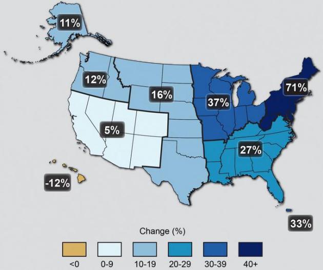
Map credit above: "
The
map shows percent increases in the amount of precipitation falling in
very heavy events (defined as the heaviest 1% of all daily events) from
1958 to 2012 for each region of the continental United States." Source: U.S. National Climate Assessment
South Carolina Flooding is the Type of Event Scientists Have Warned About for Year. Andrew Freedman has the story at
Mashable;
here's the intro: "The epic amount of rain that led to deadly,
catastrophic flooding across large parts of South Carolina and North
Carolina is an example of exactly the type of supercharged storm system
climate scientists have been warning about for years as a likely
consequence of global warming. This storm, like others that have come
before it — from a
massive deluge that flooded Oklahoma City to a
flooding event in Houston,
both of which occurred earlier this year — are examples of how the
atmosphere is behaving in new ways now that there's more water vapor and
heat for weather systems to work with..."
Photo credit above: "
Hunter
Baker surveys flood damage to his neighborhood near the flooded Black
Creek, following heavy rains in Florence, South Carolina, Monday,
October 5, 2015."
Hurricane Joaquin Helps Fuel Record Rains, Damaging Floods. Was
record warmth in the Atlantic (according to NOAA) a factor in fueling
extreme rains over the Carolinas? Here's an excerpt from
Scientific American: "...
Joaquin’s
emergence led some to posit that the record-high sea surface
temperatures this year, linked to climate change, may have played a role
in its development. There is some indication that the intensities of
Atlantic hurricanes have been increasing since the 1980s. Climate
scientists remain unsure, however, that climate change is presently
affecting hurricanes. There is simply not enough data available to
separate the contribution of natural variability in the occurrence of
such storms, said Thomas Knutson, a research meteorologist with NOAA’s
Geophysical Fluid Dynamics Laboratory..."
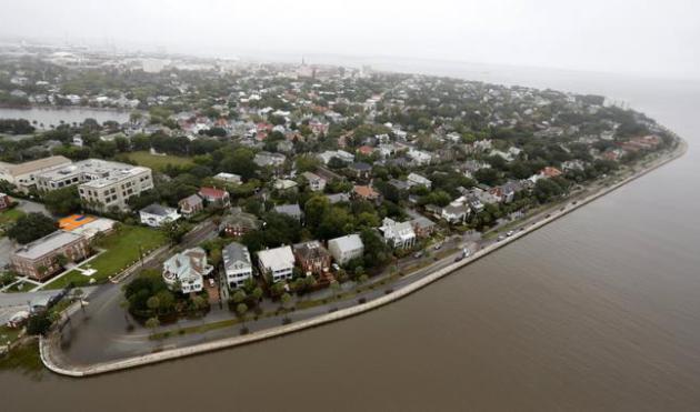
Photo credit above: "
Overall
aerial view shows historic Charleston at the Battery with minor
flooding still visible in Charleston, S.C., Monday, Oct. 5, 2015. The
Charleston and surrounding areas are still struggling with flood waters
due to a slow moving storm system." (AP Photo/Mic Smith).


No comments:
Post a Comment