61 F. high on Thursday in the Twin Cities.
59 F. average high at MSP on October 15.
66 F. high on October 15, 2014.
October 16, 1996:
Early evening storms produced 3/4 to 1 3/4 inch hail in Nicollet,
Dakota, Brown, Watonwan, and Martin Counties. In Scott County near St.
Patrick, hail fell intermittently for an hour and the area received 3
1/2 inches of rainfall. In Watonwan County, wind gusts up to 63 mph
moved several garages off their foundations, destroyed a Cattle shed and
a corn crib, and uprooted and toppled trees. Southwest of Lake Crystal
in Blue Earth County, a garage was blown over onto a vehicle. A 250
gallon fuel tank was also blown over.
October 16, 1937: Snowstorm leaves 10 inches at Bird Island.
October 16, 1880:
Earliest blizzard in Minnesota. Struck western Minnesota and the
eastern Dakotas especially hard. Over a foot of snow in western
counties. Railroads were blocked. Damage done to Great Lakes shipping.
Huge drifts exceeding 20 ft formed in the Canby area lasted until the
next spring when flooding occurred across the Minnesota River Valley.
A Mild Winter Outlook?Bug-Killing Cold
SaturdayMy
winter outlook hasn't changed. "Colder with some snow". Take it to the
bank. When in doubt, talk fast, wave your arms and deal in vague
generalities. The truth: if I could deliver a consistently accurate 3-6
month forecast I'd be sipping umbrella drinks on my own personal island.
Buyer beware.
NOAA just came out with their
prediction
for December through February. Based on a powerful El Nino warming of
the Pacific, changes in the AO (Arctic Oscillation) and the MJO
(Madden-Julian Oscillation) the forecast for Minnesota and Wisconsin
calls for milder and slightly drier than average. That's consistent with
previous El Nino events, but every warming phase is different.
That
said, I think (I hope) we won't be tracking a persistent and perpetual
polar vortex this winter. New England may get smacked, but a milder,
Pacific wind should keep us consistently milder than average, with a few
slaps of cold and snow. We'll see.
Today feels like October as the jackets come out. Clear skies and light winds set the stage for a hard freeze
tonight in the suburbs: a few hours below 28F - cold enough to kill off most plant life, including ragweed.
Plan on a sunny weekend; 70s return
Monday. The ECMWF hints at a tropical storm in the Gulf in 1 week.
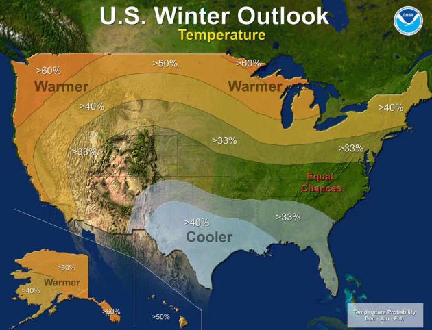
Strong El Nino Sets The Stage for 2015-2016 Winter Weather.
Will El Nino keep Minnesota somewhat warmer than usual? Odds favor that
outcome, but it's not a slam-dunk. Here's an excerpt from a story at
NOAA: "...
This
year’s El Niño, among the strongest on record, is expected to influence
weather and climate patterns this winter by impacting the position of
the Pacific jet stream. “A strong El Niño is in place and should exert a
strong influence over our weather this winter,” said Mike Halpert,
deputy director, NOAA’s Climate Prediction Center. “While temperature
and precipitation impacts associated with El Niño are favored, El Niño
is not the only player. Cold-air outbreaks and snow storms will likely
occur at times this winter. However, the frequency, number and intensity
of these events cannot be predicted on a seasonal timescale.”
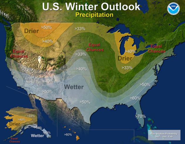
Mixed Blessing for Snow Lovers.
El Nino events tend to energize the southern branch of the jet stream,
resulting in wetter winters from California to Texas to Florida and much
of the East Coast. Will the biggest, wettest storms sail to our south
in a few months? Plausible, but more energy and volatility (and warmth)
in the system will probably result in a few significant snowfalls for
the metro. I can't promise a blockbuster winter for snowmobilers (and
kids hoping for a treadmill of snow days) but hopefully we'll see close
to average amounts, around 50-55". That's not a prediction, more of a
"wish-cast". Map: NOAA.
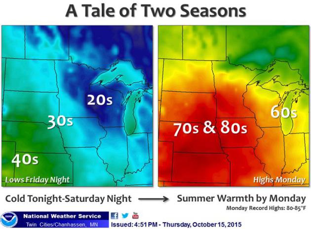
More Big Temperature Swings = Gusty Winds.
The sharper the temperature contrast over a set period of time the
stronger winds have to blow to keep the atmosphere in equilibrium. After
bottoming out in the upper 20s Saturday morning temperatures may brush
60F Sunday afternoon; 70s Monday with a few 80s south and west of MSP.
Map: Twin Cities National Weather Service.
Mild Bias Continues.
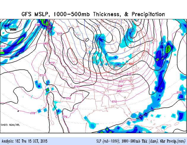
We'll see more cold fronts (there's a safe forecast with 100%
verification) but looking out 2 weeks I still see a warm ridge popping
back into place over the Rockies and Plains, a trend toward trough
formation in the west, which will trend cooler and wetter, while bubbles
of unseasonable warmth continue to push into the central USA. Watch for
possible tropical formation in the Gulf of Mexico the latter half of
next week. GFS guidance: NOAA.
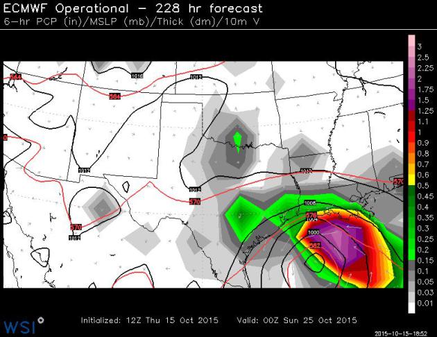
Tropical Disturbance in the Gulf of Mexico in 1 Week?
The ECMWF (European), which often does a better job with tropical
systems, spins up a tropical depression or possible tropical storm in
the Gulf of Mexico within 6-7 days. Stay tuned. Map above valid next
Saturday evening, October 24. Map: WSI Corp.
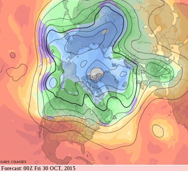
Symptoms of El Nino Finally Kicking In? Los Angeles County experienced
flash flooding and golf ball size hail
from slow-moving T-storms Thursday, evidence of unusually high dew
points and precipitable water values pushing into California (I'm in San
Diego, where it feels more like Tampa or even Miami - unusually humid
for October). El Nino should result in a southward shift in the jet with
more numerous storms impacting the west coast. 500 mb winds valid
Thursday evening, October 30 (GF) hints at increasing troughiness for
the west, with a persistant ridge of warm high pressure east of the
Rockies.
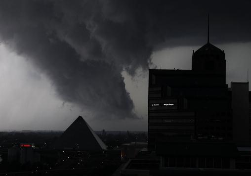
Strong El Nino Could Mean Winter Tornadoes in South.
National Geographic
connects the dots, and the implications of a more energized, high-speed
southern branch of the jet stream, spiked by El Nino. Here's an
excerpt: "...
NOAA scientists said the possibility of tornado
formation over the Deep South, including Florida, would be “elevated”
this year because of the likely conditions. Winter tornadoes are
not necessarily more powerful than twisters that form during the spring
and summer, but they usually move faster. That can make them more
deadly because it reduces the warning time and allows less time for
people to get out of harm’s way. The tornadoes move faster because the
upper-level winds that produce tornado-spawning thunderstorms are faster
during the winter..." (File photo: AP).
Don't Get Too Excited About That Giant El Nino.
It may put a dent in California's historic drought, but odds are it
won't be enough moisture, especially in northern California.
Huffington Post provides some perspective; here's a snippet: "...
While
a strong El Niño signal helps reduce the uncertainty around
[California's high weather] variability, making the wet winter more
likely in Southern California, it really offers less predictability for a
wetter than normal winter in Northern California, a region where it can
have the greatest impact in the drought," NOAA hydrologist Alan Haynes
said. "Also, remember that El Niño increases the chances for drier and
warmer weather in the Pacific Northwest, where drought has started to develop."
The California Department of Water Resources also has played down the
El Niño, urging people to look at its effects historically..." (File image credit: Associated Press).
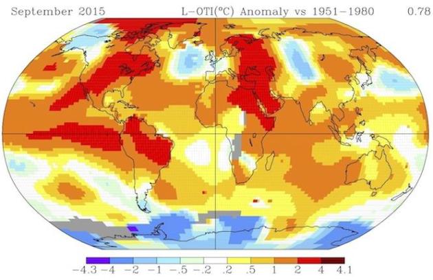
2015 Closes In On Being The Warmest Year Ever. At least in the historical record. Here's an excerpt from
Climate Central: "...
The strong El Niño event
that has taken shape this year – which could rank among the strongest
on record – has been a large factor in keeping global temperatures
elevated, but the long-term warming signal arising from the buildup of
greenhouse gases in the atmosphere has also made such heat records more
likely. According to NASA’s global temperature archive,
this September was the second warmest on record (going back to 1880),
second only to September 2014. The year-to-date is the warmest on
record, and “with three-quarters of the year already done, the ability
to change things in the last three months is limited,” Gavin Schmidt,
head of NASA’s Goddard Institute for Space Studies, which keeps the
temperature records, said in an email..."
Image credit above: "
How temperatures around the globe varied from average during September 2015, the second warmest September on record." Credit: NASA
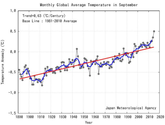
What Hiatus? Warmest September, Worldwide, on Record. Records date back to 1891; here's an excerpt from
Japan Meteorological Agency: "
The
monthly anomaly of the global average surface temperature in September
2015 (i.e. the average of the near-surface air temperature over land and
the SST) was +0.50°C above the 1981-2010 average (+0.82°C above the
20th century average), and was the warmest since 1891. On a longer time
scale, global average surface temperatures have risen at a rate of about
0.63°C per century..."
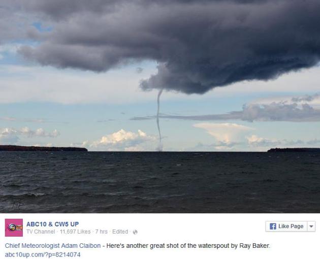
Thursday Waterspout over Lake Superior.
Water temperatures are still (relatively) mild, enough instability and
cold air aloft to whip up a rope funnel, a waterspout. Tornado Warnings
were issued for a time for Marquette County, in Michigan's UP. Thanks to
ABC 10 for the share.
America Is Increasingly Dependent on Just Two Crops, and It's Putting Us All At Risk.
Quartz has an interesting read; here's a clip: "...
In a study
published in August in PLOS One, US researchers have quantified for the
first time how much species diversity we are losing, due to our focus
on major commodity crops—up to 19% in some areas. The danger of a drop
in crop species diversity has been recognized for decades now:
As farmers plant more and more commodity crops like corn, they’re
planting fewer alternatives, leading to a loss in crop diversity, which
makes the country’s food supply more vulnerable to problems like pests
or climate change..." (Image credit: NebraskaCorn.org).
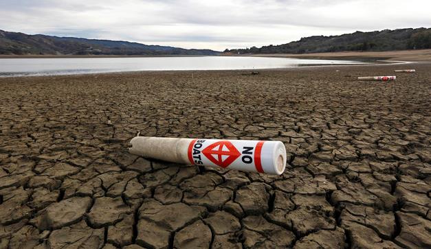
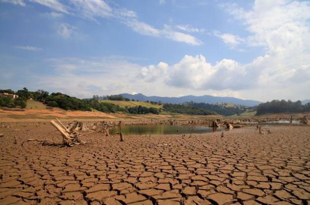
A Megacity Without Water: Sao Paulo's Drought.
TIME
has a sobering update on what's happening right now in Brazil, and how
other cities may face similar water shortages in the years to come.
Here's an excerpt: "
The biggest city in the Western hemisphere is facing its greatest water crisis in over 80 years — and climate change is only part of the problem. Millions of residents in São Paulo, Brazil face daily water shutoffs
unless the city manages its water better. It is not only a problem of
drought. The city of 20 million is plagued by failing infrastructure
across the city, and it has been unable to deliver the water it does
have to residents in need. Without major changes to the city’s
infrastructure and planning, commentators say the crisis is bound to
continue..."
File photo above: "
View of drought in
Rio Jacarei, region of Joanopolis, interior of Sao Paulo, southeastern
Brazil, on February 14, 2014. The level of Cantareira System, abastace
dam that almost 9 million people in Sao Paulo is in 18.7%, the lowest
level since 1974." Photo by: LUIS MOURA/picture-alliance/dpa/AP Images
Bill Gates: "We Need an Energy Miracle". Will technology save us from ourselves? Here's an excerpt of a fascinating interview at
The Atlantic: "...
Gates
is on a solo global lobbying campaign to press his species to
accomplish something on a scale it has never attempted before. He wants
human beings to invent their way out of the coming collision with
planetary climate change, accelerating a transition to new forms of
energy that might normally take a century or more. To head off a rise in
average global temperatures of 2 degrees Celsius above preindustrial
levels—the goal set by international agreement—Gates believes that by
2050, wealthy nations like China and the United States, the most
prodigious belchers of greenhouse gases, must be adding no more carbon
to the skies..."
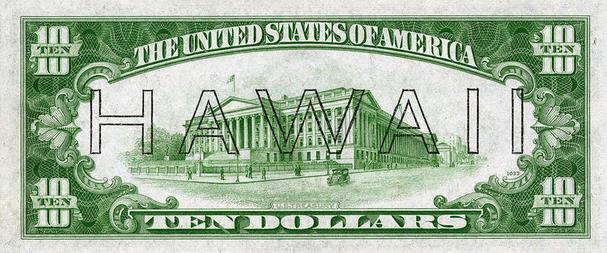
Object of Intrigue: Banknotes for a Japanese-Occupied Hawaii. I had no idea - here's an excerpt from
Atlas Obscura: "
In
early 1942, the United States government began issuing a special set
of banknotes custom-made for Hawaii. The back of each note looked
identical to the existing U.S. paper currency apart from one major
difference: the word "HAWAII" was stamped across it. The design of these
notes wasn't the most elegant—the "HAWAII" looked as though it was
inscribed by someone with a black ballpoint pen and a ruler. But that's
understandable, given their circumstances: these banknotes were an
emergency series, rushed to print in the months following Japan's attack
on Pearl Harbor..."
Image credit above:
National Numismatic Collection, National Museum of American History).
A Photographer Edits Out Our Smartphones To Show Our Strange and Lonely New World.
This is a little creepy, but it makes a good point: we spend an awful
lot of time staring at our phones. Here's an excerpt from Quartz: "Are
you reading this on a handheld device? There’s a good chance you are.
Now imagine how’d you look if that device suddenly disappeared. Lonely?
Slightly crazy? Perhaps next to a person being ignored? As we are sucked
in ever more by the screens we carry around, even in the company of
friends and family, the hunched pose of the phone-absorbed seems
increasingly normal..."
Photo credit: "
Out of hand."
Eric Pickersgill.
Your Birth Month May Affect How Healthy You Are. Um, not sure what to do with this information. Here's a clip from Huffington Post: "Being
born in the summer could come with some big health benefits, according
to a provocative new study by researchers at the University of
Cambridge's Medical Research Council Epidemiology Unit in England. The study showed that people with birthdays in June, July or August are
less likely than others to have low birth weight, enter puberty early
or be of short stature. "Those are all markers of growth and development
that have been associated with higher risks of adult diseases,"
said Dr. Ken Ong, a pediatric endocrinologist at the unit and co-author of the study, in an email to The Huffington Post..."
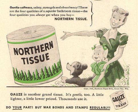
How Green Bay Became The Toilet-Paper Capital of the World. I had no idea - here's an excerpt from
Atlas Obscura: "...
Yet
toilet paper was still a niche product, reserved for the rich or
hemorrhoidal. It was not until the popularity of indoor plumbing took
off—and the pages of the previously used catalogues proved
unflushable—that the paper mills of Green Bay turned their covetous eyes
on the nation’s backsides. Perhaps it was not surprising that Green Bay
should have achieved such coprophilic success. After all, the area had
originally been named La Baie des Puants, “The Bay of Stinkards,” by early French explorers because of the odiferous green algae in the water..."
Image credit above: "
A 1943 advertisement for Northern Tissue." (Photo: SenseiAlan/flickr)
TODAY: Partly sunny, brisk. Winds: NW 10-15. High: 49
FRIDAY NIGHT: Heavy jackets for football games. Clear and frosty. Low: 30
SATURDAY: Hard freeze early. Cool sun with light winds. Winds: SW 5-10. High: 52
SUNDAY: Sunny and windy. Winds: SE 10-20. Wake-up: 37. High: 59
MONDAY: Some sun, lukewarm again. Wake-up: 46. High: 72
TUESDAY: Clouding up, showers late. Wake-up: 56. High: 65
WEDNESDAY: Cooler, few showers linger. Wake-up: 52. High: 57
THURSDAY: Cool sunshine returns. Wake-up: 41. High: 52
Climate Stories...
Acceptance of Global Warming Among Americans Reaches Highest Level Since 2008. Here's a clip from a press release at The Center for
Local, State and Urban Policy at the University of Michigan: "
For
the first time since 2008 at least 7 out of 10 Americans indicate that
they believe there is solid evidence of global warming over the past
four decades. This 70% belief level is the second highest mark in the
history of the National Surveys on Energy and the Environment (NSEE)
falling just short of the 72% record level reported in Fall 2008. This
increased level of acceptance of evidence of global warming coincides
with the lowest percentage of Americans expressing doubt in solid
evidence of global warming in the history of the NSEE. The Fall 2015
survey shows that only 16% of adult Americans currently believe there is
not solid evidence of global warming, a mark 1% lower than the previous
record of 17% recorded in Fall 2008..."
Energy, Mining Companies Begin to Back Back Climate Talks. Here's the intro to a stor at
The Wall Street Journal: "
A
major international agreement to reduce carbon-dioxide emissions is
starting to draw in major energy and mining companies. Some global
companies, especially those that face heavy environmental regulation,
say they are supportive of nearly 200 countries’ efforts to reach an
accord in Paris in December at negotiations sponsored by the United
Nations. On Wednesday, a dozen companies, including oil giant BP PLC and global mining giant BHP Billiton Ltd. released a statement touting the Paris climate talks as a “critical opportunity to strengthen efforts globally addressing the causes and consequences of climate change...” (File photo: Shutterstock).
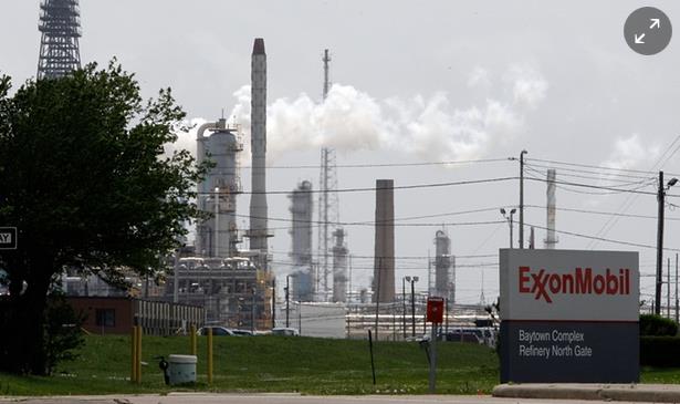
Exxon's Climate Lie: "No Corporation Has Ever Done Anything This Big or Bad". That's quite a statement, but Bill McKibbon backs up his claim with specifics in
The Guardian. Here are a couple of excerpts: "...
They
helped organise campaigns designed to instil doubt, borrowing tactics
and personnel from the tobacco industry’s similar fight. They funded
“institutes” devoted to outright climate denial. And at the highest
levels they did all they could to spread their lies....
Instead,
knowingly, they helped organise the most consequential lie in human
history, and kept that lie going past the point where we can protect the
poles, prevent the acidification of the oceans, or slow sea level rise
enough to save the most vulnerable regions and cultures. Businesses
misbehave all the time, but VW is the flea to Exxon’s elephant. No
corporation has ever done anything this big and this bad..."
Photo credit here: "
By
1978 Exxon’s senior scientists were telling top management that climate
change was real, caused by man, and would raise global temperatures by
2-3C." Photograph: Pat Sullivan/AP.
* More perspective from
Huffington Post.
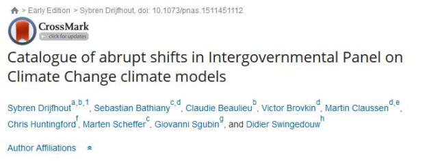
Anticipating "Abrupt Changes" in a Changing Climate. We
know there will be tipping points, but the details of how, when and why
are still murky and nebulous. Here's an excerpt of an paper abstract at
PNAS: "...
We
do find abrupt changes in sea ice, oceanic flows, land ice, and
terrestrial ecosystem response, although with little consistency among
the models. A particularly large number is projected for warming levels
below 2°. We discuss mechanisms and include methods to objectively
classify abrupt climate change..."
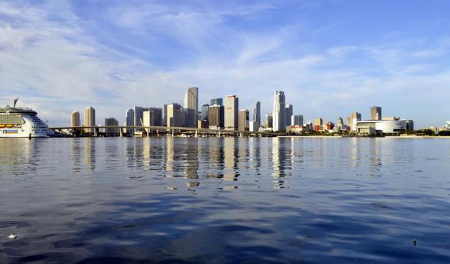
The U.S. Cities That Will Stay Above Sea Level After Global Warming - And The Ones That Will Disappear. Alarmist? I sure hope so, but you might want to think twice before purchasing beachfront property. Here's an excerpt from
Quartz: "...
The
map uses four different scenarios laid out by the Intergovernmental
Panel on Climate Change. In the best case, aggressive cuts would cause
carbon emissions to peak within the next five years; in the worst case,
pollution goes unchecked and emissions continue climbing through the
year 2100. Even with aggressive carbon cuts, cities like Miami and
Jacksonville, Florida, could lose more than half their land. New York
and Boston are in danger of shrinking by a quarter..." (Miami file image: Wikipedia).
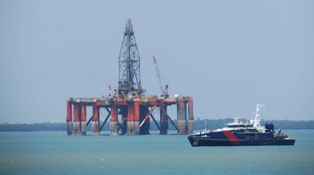
BP Admits Climate Concern Makes Some Oil Unburnable.
Stranded assets? Even the top oil producers now admit that much of the
oil will need to remain in the ground to avoid potentially catastrophic
warming; here's an excerpt from
Climate Home: "
Some
of the world’s oil will not be burned as a result of climate concerns,
BP’s chief economist said on Tuesday. Scientists have calculated
around a third of proven oil reserves need to stay in the ground to
hold global warming to 2C, the international goal. Spencer Dale’s
remarks, in a speech to the Society of Business Economists in London,
represented a rare acceptance of that analysis from the industry..."
Photo credit above: Flickr/Ken Hodge.
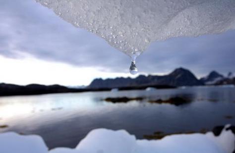
Excuses for Climate Inaction Melt Away: Our View. Here's the intro of an Op-Ed from the Editorial Board at
USA TODAY: "
With
every passing month, the arguments for inaction on climate change are
melting away faster than glaciers in Alaska. Let’s take them one at a
time. Argument No. 1: The science is uncertain. Actually, it’s not. An
overwhelming majority of climate scientists agree that human activity is
warming the planet. In fact, based on global surface temperatures, 2015 is on track to eclipse 2014 as the warmest year on record. This past summer was the hottest in recorded history,
topping 2014 and even 1998, which featured an El Nino-driven spike that
has allowed skeptics to claim, misleadingly, that temperatures haven’t
increased much since then..."
Photo credit above:
An iceberg melts in Kulusuk, Greenland, near the Arctic Circle in 2005.(Photo: John Mcconnico, AP)
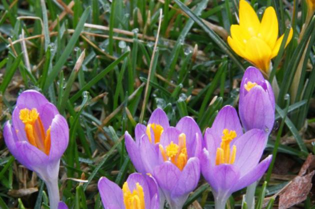
Climate Change Means Spring Could Come 3 Weeks Earlier Across U.S. The growing season is already longer for many northern locations.
NBC News has the story; here's a snippet: "
Spring flowers may arrive as much as three weeks earlier over the next century as climate change
drives an earlier end to winters in areas of the United States,
researchers say in a new report. Warmer weather earlier in the year
might have consequences for farmers as well as wildlife,
said the researchers from the University of Wisconsin, U.S. Geological
Survey and U.S. Fish and Wildlife Service. Their report was published in
the journal Environmental Research Letters..."


No comments:
Post a Comment