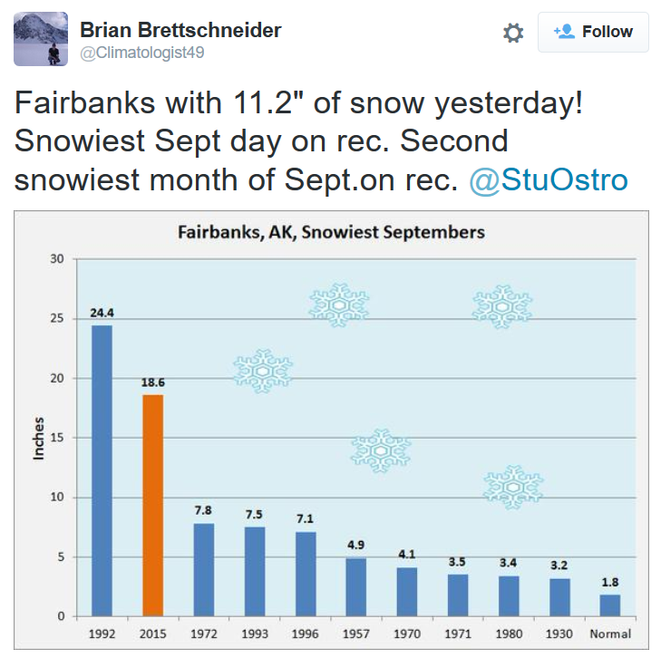
OK - sorry to shock you, but I had to share this. Thanks to my good friend Jane Taffe from Fairbanks, AK for the picture below. Incredibly, 11.2" of snow fell there on Tuesday making it not only a daily snowfall record, but it also became the snowiest September day on record!

Thanks to @Climatologist49 for this tweet. Note that with the additional 11.2" of snow on Tuesday, Fairbanks, AK has its 2nd snowiest September on record with 18.6" !! Hello winter!
______________________________________
Continued cool and dry weather
By Todd Nelson, filling in for Douglas
Happy October! And wow, does it ever feel like it, no? If you're keeping track, September finished nearly 6 degrees above average. We spent 11 days in the 80s, the most recent was last Sunday. Thanks to a fairly robust Canadian cold front, temperatures have dropped nearly 20 degrees since then. Pants and sweaters are starting to make appearances after being tucked away in the away in the back of the closet since Spring. Don't get me wrong, I love this weather too, but that summer. Oh, that summer! It's going to be hard to let go.
While continued cool and dry weather continues for us through the weekend, the weather around us is quite active. Get this, parts of California could see nearly 1 inch of rain through early next week! Hopefully El Nino is good to those dealing with incredible drought in the Western U.S..
Meanwhile in the Atlantic, Joaquin became the first Category 4 hurricane of the 2015 season as it hammered the Bahamas on Thursday. Thankfully, latest trends suggest a slight nudge east away from the East Coast. Don't let your guard down yet.
___________________________
THURSDAY NIGHT: Mostly clear and cool. Winds: E 5-10. Low: 41
FRIDAY: Blue sky, no drama. Winds: E 5-10. High: 62.
FRIDAY NIGHT: Mostly clear and cool. Winds: E 10. Low: 40.
SATURDAY: More chilly sun, still dry. Winds: E 5-10 High: 62
SUNDAY: Sunny start, clouds thicken late. Showers possible overnight north. Winds: E 5-10. Wake-up: 41. High: 59
MONDAY: A few passing showers, mainly north. Wake-up: 44. High: 65
TUESDAY: More sun, near average. Wake-up: 46. High: 64
WEDNESDAY: Dry start. Showers develop late. Wake-up: 48. High: 65
THURSDAY: Showers, thunder possible. Wake-up: 43. High: 61.
___________________________
This Day in Weather History
October 2nd
1953: A record high of 90 degrees Fahrenheit for the St. Cloud area was recorded in 1953 (and later tied in 1992). Minneapolis also set a record that same day in 1953 with a high of 89 degrees.
1849: Persistent rain at Ft. Snelling leaves 4 inches in a day-and-a half.
____________________________
Average High/Low for Minneapolis
October 2nd
Average High: 65F (Record: 89F set in 1953)
Average Low: 45F (Record: 22F set in 1974)
_____________________________
Sunrise/Sunset Times for Minneapolis
October 2nd
Sunrise: 7:12am
Sunset: 6:52pm
*Daylight lost since yesterday: ~3 minutes and 6 seconds
*Daylight lost since summer solstice (June 21st): ~3 hours and 57 minutes
_________________________________
Moon Phase for October 2nd at Midnight
1.6 Days Before Last Quarter
___________________________________________
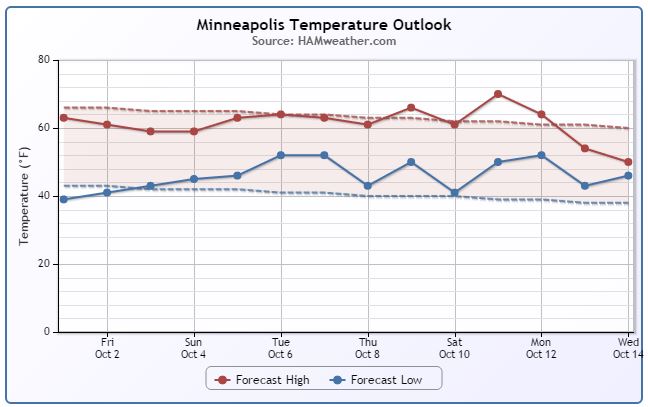
Minneapolis Temperature Trend
A cool bubble of high pressure located over the Hudson Bay is helping to supply us with MUCH cooler temperatures than what we had last weekend. Slightly below average temperatures look to continue over the next few day with a gradual warming trend into next week.
_________________________
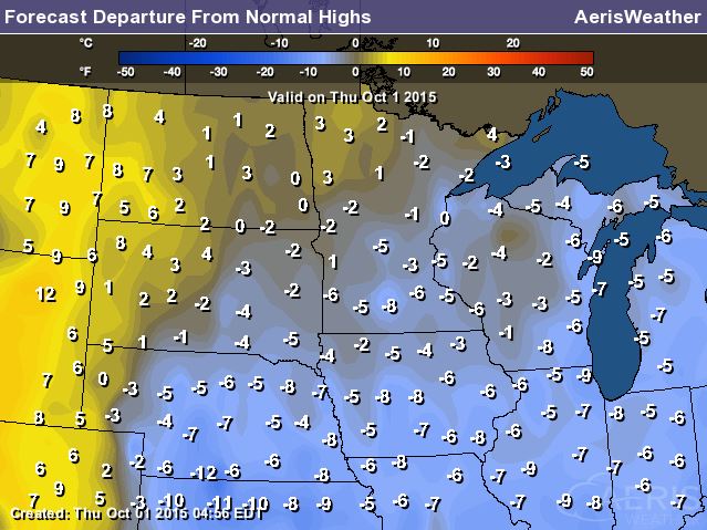
Highs From Average Friday
High temperatures on Friday still look to be running a little bit below average across much of the state. Some of the coolest readings will be found in the middle part of the country with highs nearly 15F to 20F below average!
Friday Weather Outlook
Despite temperatures running a little below average, Friday won't be a bad day at all. Plenty of sunshine and highs flirting with 60F is manageable for mid October!
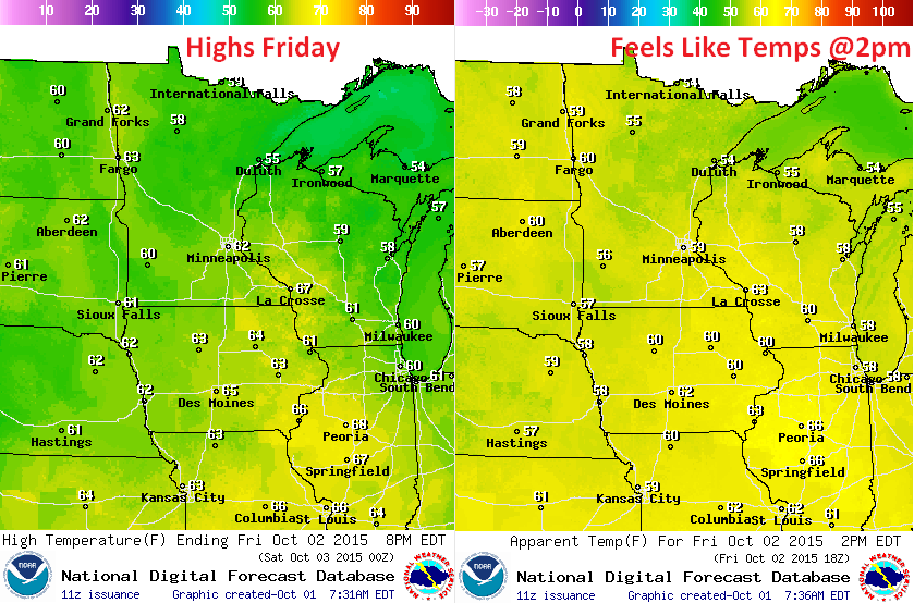
Friday Weather Outlook
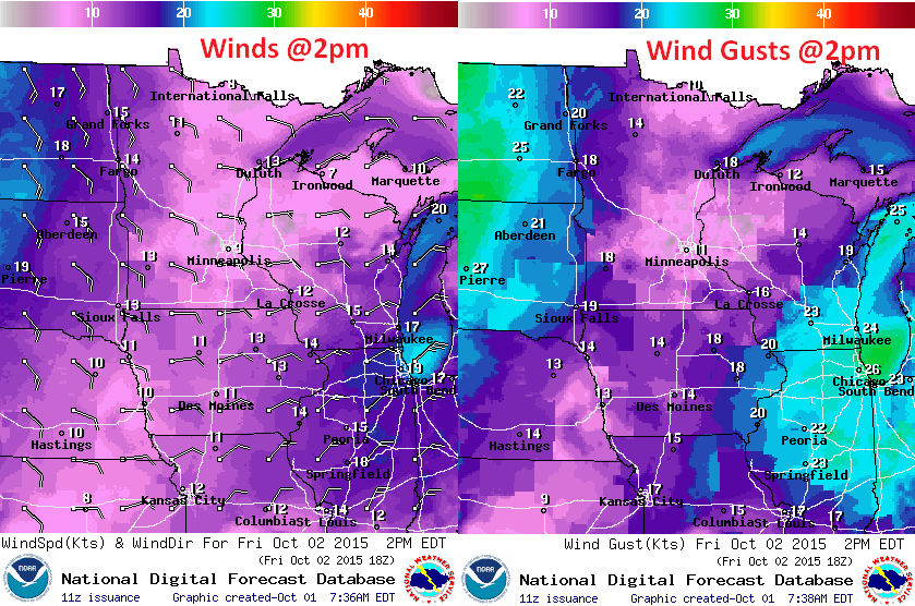
A cool breeze continues Friday with some of the strongest wind gusts located over far western MN/Dakotas and through the Great Lakes Region.
Friday Weather Outlook
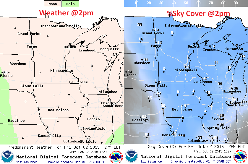
No rain threat in sight on Friday. In fact, it might be hard to find a cloud with cool blue skies overhead.
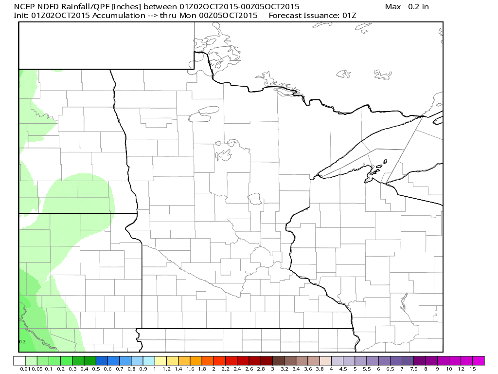
Rainfall Potential
Rainfall potential through PM Sunday doesn't look all that impressive. In fact, much of the state should continue with mostly sunny skies through the weekend with temperatures at or slightly below average. Enjoy your first weekend of October!
___________________________________
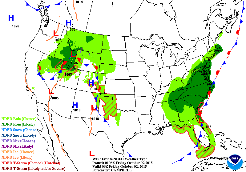
National Weather Outlook
There are two main areas of precipitation that will be impacting parts of the nation through the next couple of days. The first of which will be found across the Intermountain West/Plains and the second will be the significant rainfall threat in the Eastern U.S.. Significant rainfall will be possible over the next couple/few days near the Mid-Atlantic region, while Hurricane Joaquin looks to begin lifting north.
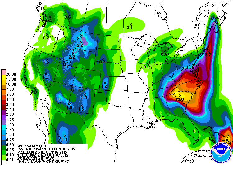
Precipitation Outlook
According to NOAA's WPC, the 5 day rainfall forecast suggests decent moisture of nearly 1" to 2"+ across parts of the Western U.S., while the most significant rainfall will be found near the Carolinas. Note the forecast maximum of nearly 20" in western South Carolina!! YIKES!
______________________________
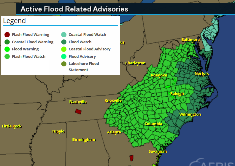
Flood Concerns
Take a look at all the flood concerns that are in place across the Mid-Atlantic States. Take a look at the Flash Flood Watch Statement from the National Weather Service out of Greenville-Spartanburg, SC office:
...HEAVY RAIN EXPECTED ACROSS WESTERN NORTH CAROLINA THIS WEEKEND WITH POTENTIALLY HISTORIC AND LIFE THREATENING FLASH FLOODING POSSIBLE...
.A SLOW MOVING UPPER LOW WILL INTERACT WITH MOISTURE FROM TROPICAL CYCLONE JOAQUIN TO PRODUCE COPIOUS AMOUNTS OF RAIN ACROSS THE WESTERN CAROLINAS AND NORTHEAST GEORGIA. HEAVY RAIN IS EXPECTED TO DEVELOP ON FRIDAY AND WILL CONTINUE PERIODICALLY THROUGH SATURDAY AND SUNDAY. ALTHOUGH SOME UNCERTAINTY REMAINS AS TO THE AMOUNT...THERE IS GROWING CONFIDENCE THAT A WIDESPREAD FIVE TO TEN INCH RAINFALL WILL OCCUR...WITH A BAND OF TEN TO FIFTEEN INCHES POSSIBLE SOMEWHERE ACROSS THE WESTERN CAROLINAS. THIS AMOUNT OF RAINFALL COULD BE HISTORIC AND COULD RESULT IN SIGNIFICANT...LIFE THREATENING...FLASH FLOODING.
________________________________________
Hurricane Joaquin
While heavy rain falls over the Mid-Atlantic, Hurricane Joaquin continues in the Atlantic. Interestingly, Joaquin became our first category 4 storm of the 2015 Atlantic Hurricane Season as it hammered the Bahamas on Thursday. The image below shows the intense circulation from Hurricane Joaquin
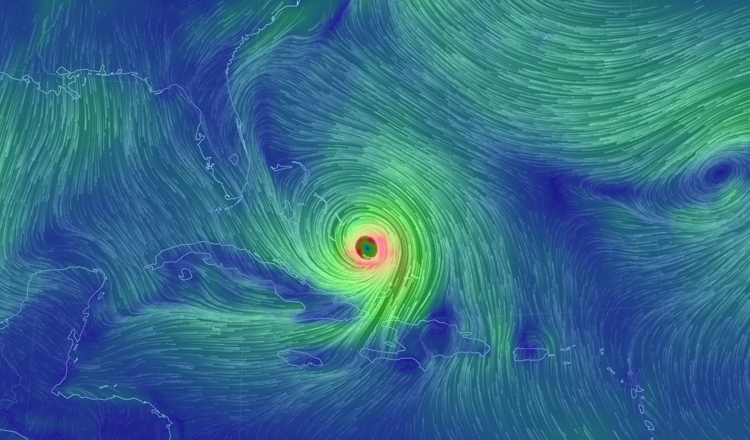
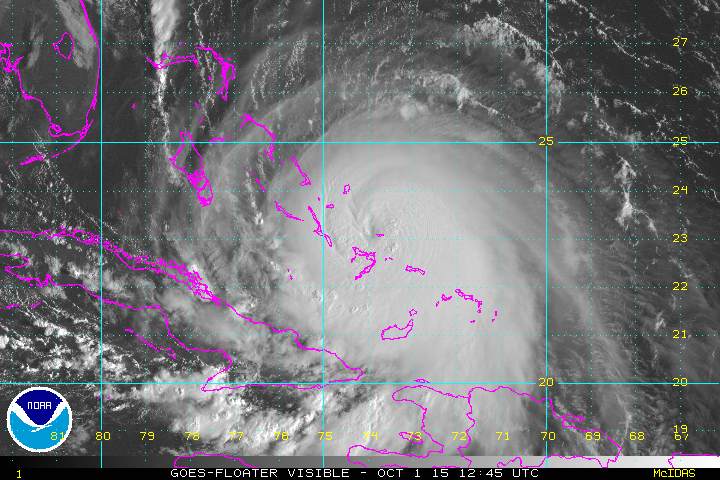
Joaquin: Visible Satellite
This was the visible satellite from late Thursday afternoon. Note that Joaquin started to form an eye as it gained category 4 strength.
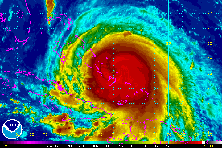
Joaquin: IR Satellite
Here's a different look from the same time frame above. This is the IR Satellite, which tells us how cold cloud tops are. The bright reds indicate the tallest, coldest cloud tops with the eye in the center.
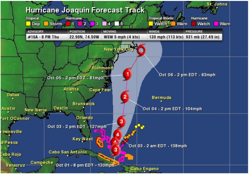
National Hurricane Center Forecast Track
The forecast track from the National Hurricane Center suggests a slight nudge in the easterly direction from prior forecasts. This is good news! The other good news is that Joaquin looks to lose strength as it heads north over the next several days... Stay tuned!
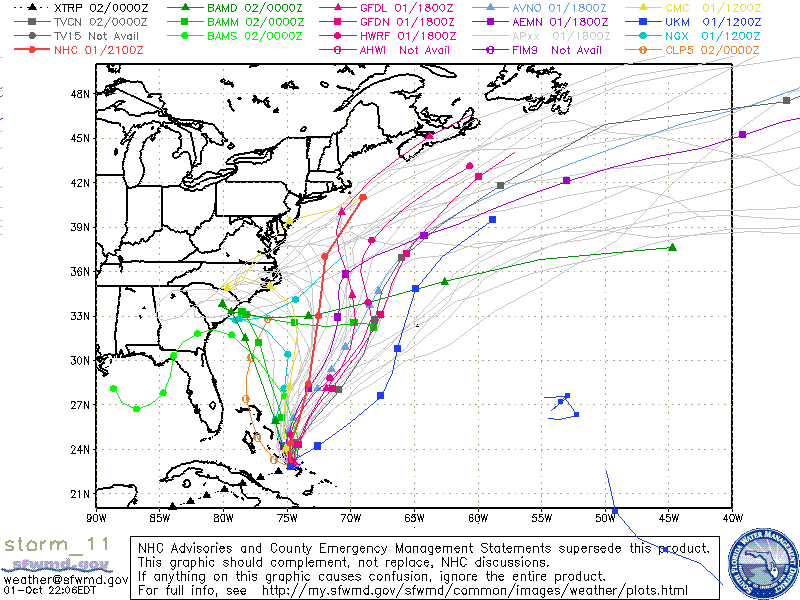
Spaghetti Plot
Here's the Spaghetti Plot... it shows a number of different models and their solutions to Joaquin. Note that several solutions take Joaquin east, more away from the East Coast than previous forecasts.
GFS Solution
Here's the GFS solution for 1pm Sunday. Note that the forecast is much farther east than it was previously!

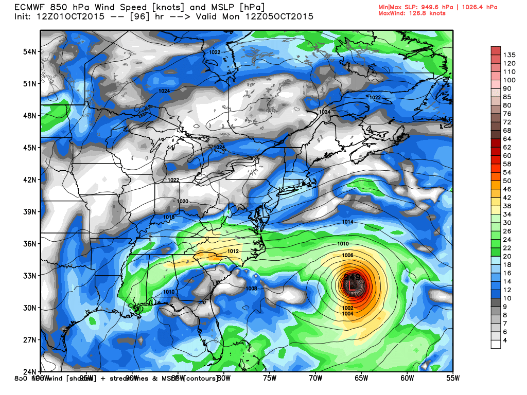
European
If you've been keeping track, the European model has continued to keep Joaquin well away from the East Coast and looks like it may be pushing it a little farther east than before.
Thanks for checking in and have a great rest of your week/weekend ahead! Don't forget to follow me on Twitter @TNelsonWX

No comments:
Post a Comment