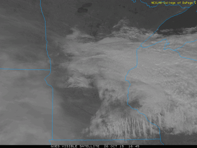
Here's the visible satellite loop below from Monday, which showed widespread cloud cover much of the day across much of the state. If you look near the end of the loop, you can see the a large swath of clouds moving from west to east, this is the beginning of our next system that will merge with the remnants of Patricia midweek and bring not only cold, wind-whipped rain showers to the region, but also a chance of snow showers across parts of the area.
5 Years Ago: October 26h - 27th, 2010
Take a look at some of the images and data from this particular event 5 years ago. From hurricane force winds to blizzard-like conditions to severe weather, this was an incredible event!
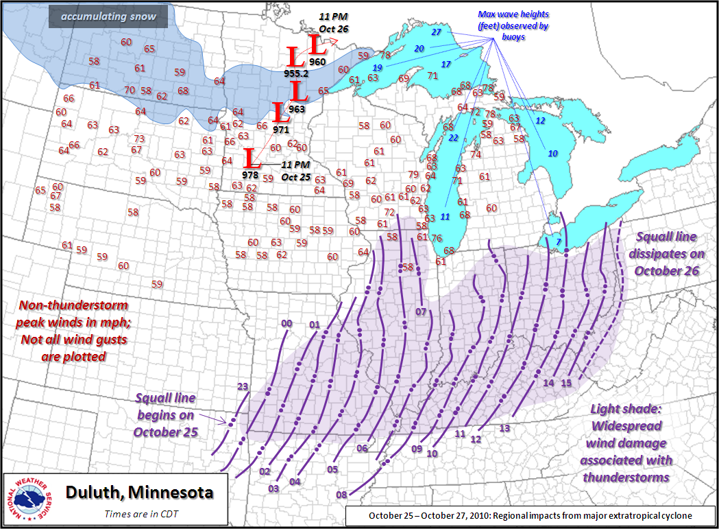
"October 26th marked the 5 year anniversary of one of the strongest storms on record. The lowest pressure recorded was 955.2 mb, which is equivalent to a Category 3 hurricane."
See more from the Minnesota State Climate Office HERE:
"This storm set records for the lowest pressure ever recorded in Minnesota (Bigfork, MN - 955.2 mb / 28.21" - 5:13 p.m. October 26, 2010) and Wisconsin (Superior, WI - 961.3 mb / 28.39" - 11:15 a.m. October 26, 2010)"
See more from the National Weather Service Office La Crosse HERE:
"In the Northland area, this storm had a wide variety of impacts. A lot of precipitation fell across the region, and in our area the highest total through the morning of October 27th was 5.50" of liquid precipitation 7 miles northwest of Two Harbors, MN (Lake County). Some of that precipitation changed over to snow on the evening of October 26th, and a band of generally 2 to 6 inches of snow developed from Fort Ripley, through the Brainerd area, up towards southern St. Louis County, and along the north shore of Lake Superior to near Tofte. Isolated totals of up to 9 inches were reported just northwest of Duluth."
See more from the National Weather Service Office Duluth HERE:
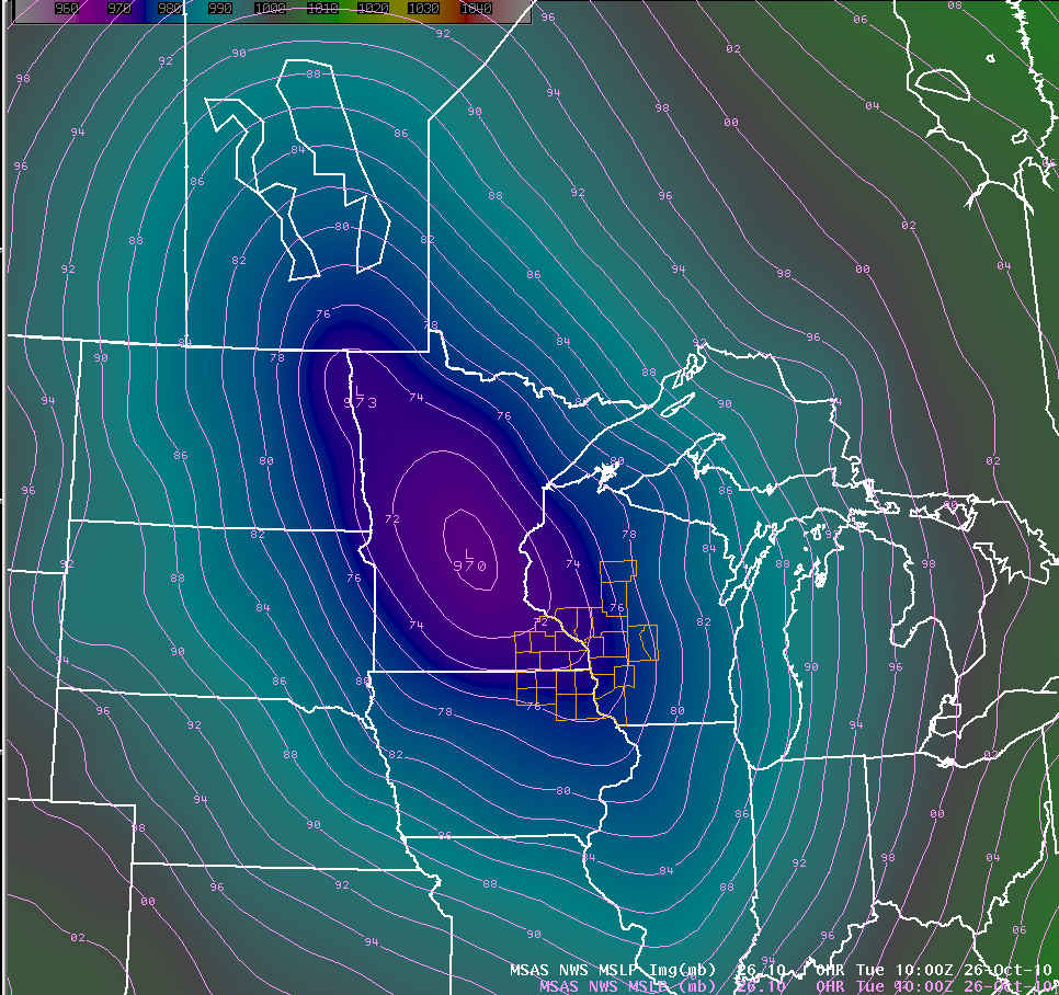
Tight Pressure Gradient: October 26th, 2010
Here's a screen grab that I took 5 years ago as the storm was near it's lowest pressure. Note how close the lines of equal air pressure were (black lines). This indicates a VERY intense wind field that had many wind gusts surpassing the severe thunderstorm wind threshold of 58mph.
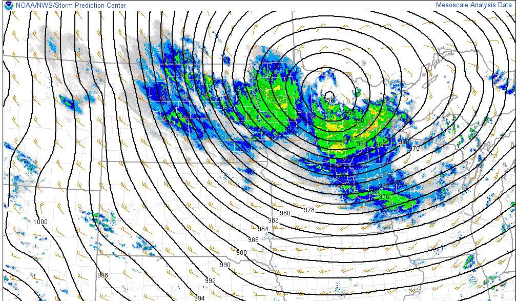
October 26th - 27th, 2010 Storm Track
Widespread reports of strong winds can be seen across much of the Midwest/Great Lakes Region, while heavy snow/blizzard-like conditions were ongoing across the Dakotas. There was also severe weather across parts of the Ohio Valley!
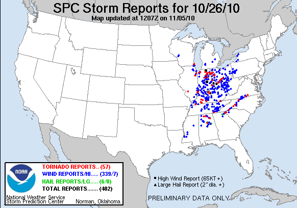
Severe Weather Reports October 26th, 2010
According to NOAA's SPC, there were nearly 400 storm reports on October 26th, 2010, 57 of which were tornadoes. 1 of the tornadoes injured 2 people in Kenosha, WI!
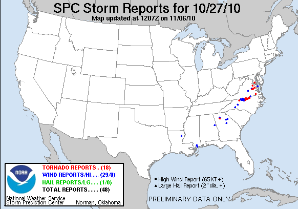
Severe Weather Reports October 27th, 2010
The front lost a bit of it's oomph, but still managed to produce nearly 50 severe weather reports on October 27th. 18 of those reports were tornadoes, mainly in the Mid-Atlantic States.
First Fistful of Flurries Possible Wednesday
By Paul Douglas
I'm still standing. The sun was shining Saturday as my oldest son got married at a 100-year old lodge on the northern tip of Gull Lake. I want to thank Walt and Tracy for restoring my faith in love, the institution of marriage, and everything good in the world. I feel blessed - and old, in that order.
The same El Nino warming event in the Pacific that spiked Hurricane Patricia may keep the steering winds howling above Minnesota blowing from the west for more of the winter than usual, deflecting some of the coldest air across Canada into New England. There will be exceptions, in fact by Wednesday there will be little doubt in your mind that the sun is now as high in the sky as it was back in mid-February.
Some of the moisture leftover from "Patricia" wraps around a storm spinning up over the Great Lakes, brushing us with rain later Tuesday and Tuesday Night. By Wednesday it may be cold enough to peer out your window and spot a few renegade flurries. Nothing will stick, not yet.
Skies clear over the weekend; models hinting at a 60-degree breeze Sunday. I can live with that.
__________________________________
MONDAY NIGHT: Mostly cloudy, chance of sprinkles early. Winds: SE 5mph. Low: 46.
TUESDAY: More PM clouds, rain develops late. Winds: ESE 15mph. High: 59
TUESDAY NIGHT: Cloudy with rain. Winds: ESE 5-10. Low: 45.
WEDNESDAY: Windy. Cold rain with a mix possible north. Winds: NW 15-30mph. High: 47
THURSDAY: Breezy. A few spits of cold rain early. Winds: NW 10-20mph. Wake-up: 36. High: 50.
FRIDAY: Fading sun, rain at night? Wind: S 10-15mph. Wake-up: 34. High: 53.
SATURDAY: Witch watch. Wet start, slow clearing. Wake-up: 43. High: 55.
SUNDAY: Sunny. Mild breeze. Winds: SW 10-15mph. Wake-up: 44. High: 63.MONDAY: Clouds increase, cooler. Winds: NW 10-20mph. Wake-up: 52. High: 58.
____________________________________
This Day in Weather History
October 27th
1943: Said to be one of the worst fogs in the Twin Cities in memory. A very dense area of fog, with an average of 75 feet in thickness, blanketed the area. At the worst, street lights could not be seen 25 yards away. Drivers refused to cross unmarked railroad crossings and traffic was brought to a standstill.
1931: Storm hits the Duluth area. Barometer falls to 29.02.
____________________________________
Average High/Low for Minneapolis
October 27th
Average High: 53F (Record: 74F set in 1948)
Average Low: 36F (Record: 13F set in 1997)
_____________________________________
Sunrise/Sunset Times for Minneapolis
October 27th
Sunrise: 7:44am
Sunset: 6:09pm
______________________________________
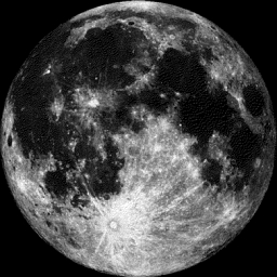
Moon Phase for October 27th at Midnight
0.8 Days After Full Hunter's Moon
"With the leaves falling and the deer fattened, it is time to hunt. Since the fields have been reaped, hunters can ride over the stubble, and can more easily see the fox as well as the other animals that have come out to glean — all of which can be caught for a thanksgiving banquet after the harvest."
See more from SpaceWeather.com
_______________________________________
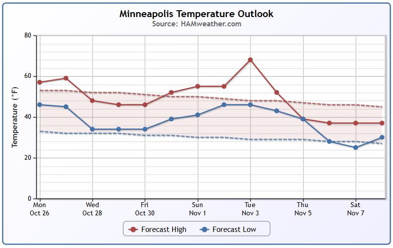
Minneapolis Temperature Trend
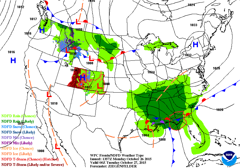
The remnants of Hurricane Patricia and an approaching cold front from Canada will help to whip up a fairly decent storm across the Upper Midwest/Great Lakes Region through Midweek. Cold, wind-whipped rain showers will be likely across a wide area, however, there may also be a few areas near the international border that see mixed precipitation and snow! Temperatures will take a dip to below average readinds after the storm moves east of us, but it appears we may be in for a brief warm up by early November!
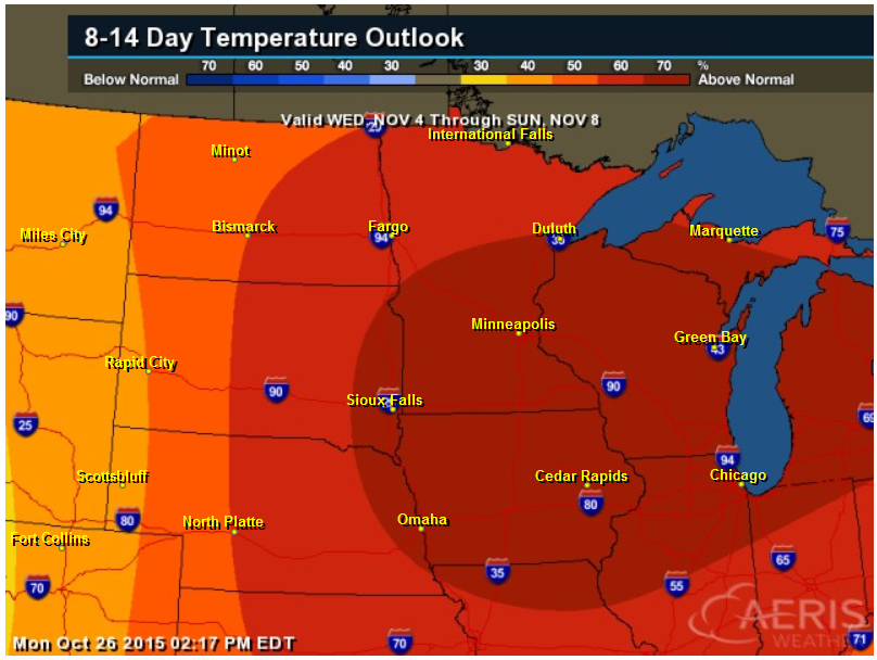
8 to 14 Day Temperature Outlook
According to NOAA's CPC, the 8 to 14 day temperature outlook suggests warmer than average conditions into early November. Again, note the temperature trend image above, it appears that the warm up will be brief.
___________________________________
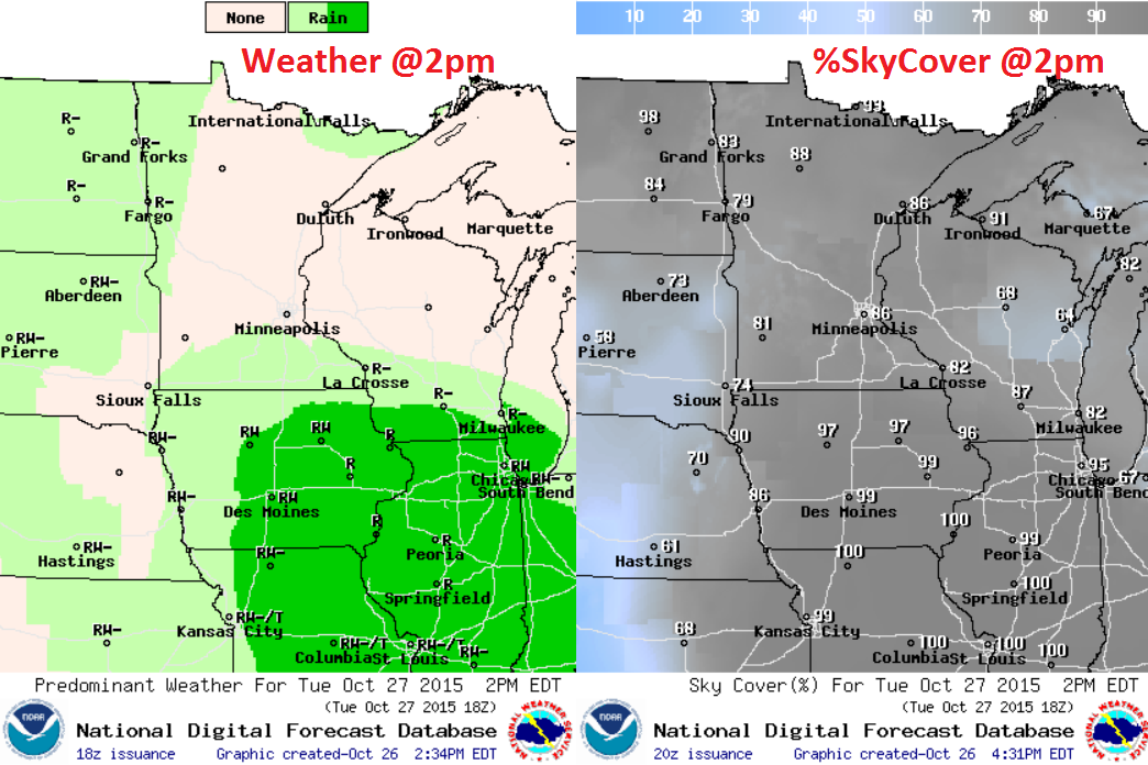
Tuesday Weather Outlook
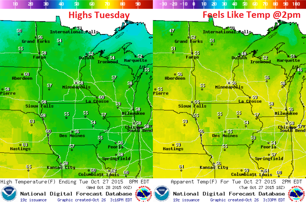
Tuesday Weather Outlook
Tuesday Weather Outlook
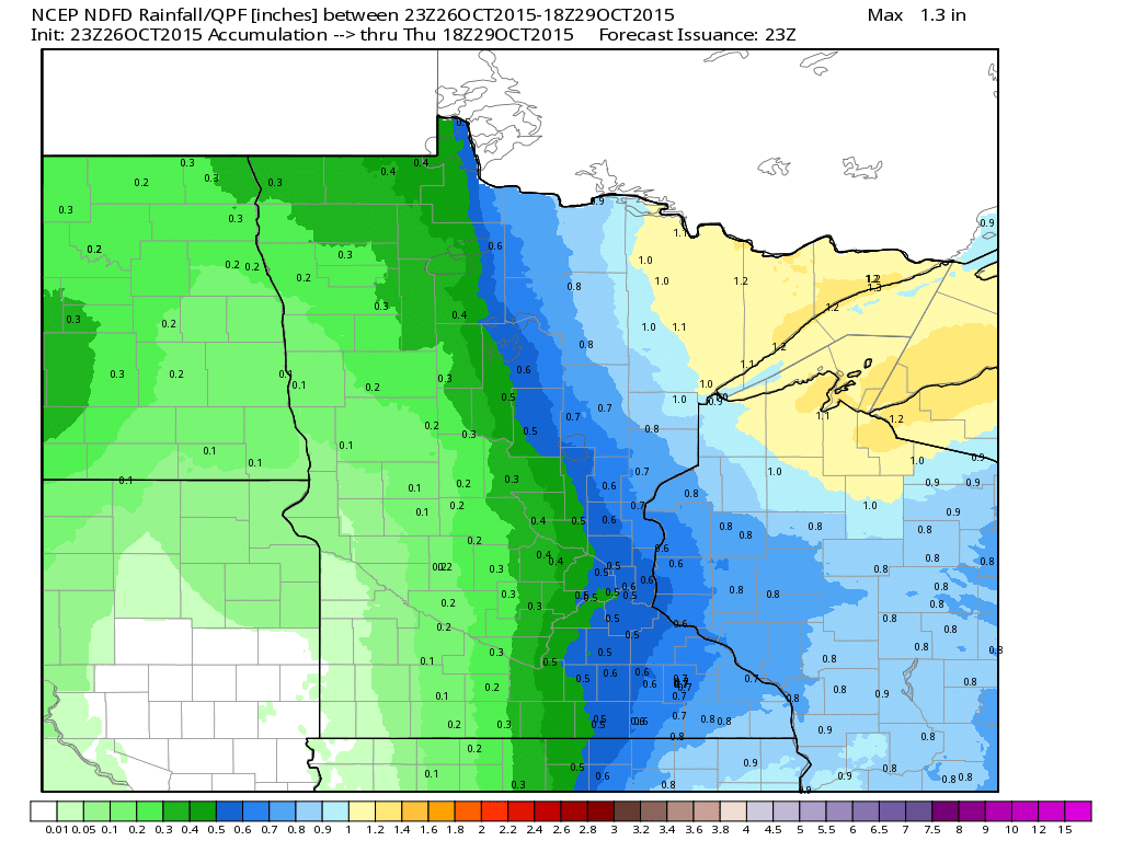
Minnesota Rain Potential
Rainfall potential will increase rapidly PM Tuesday - Wednesday across the region, especially across extreme eastern MN through Wisconsin. Precipitation amounts could approach 1"+ in a few spots along and east of the Mississippi Valley, but rain tallies will be much lighter to the west.
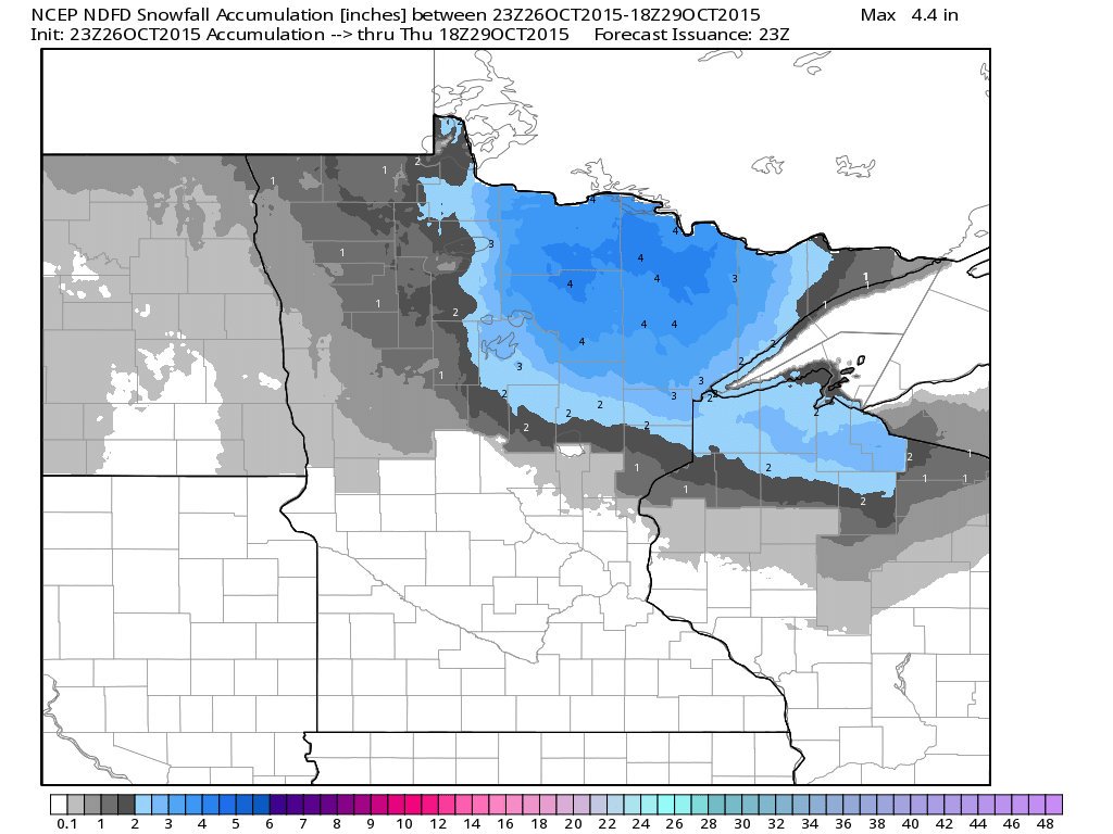
Snowfall Potential
Interestingly, we're getting some feedback in the snowfall department. The image below suggests a slushy coating possible across the northern part of the state through PM Wednesday... stay tuned!
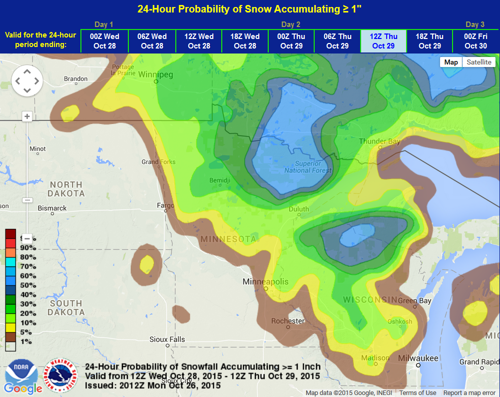
Probability of Snow Accumulation of 1"
Here's a product from NOAA's WPC, which suggests the probability of snow accumulation of 1" or more. Note that parts of northeastern MN have nearly a 50% chance.
_________________________________
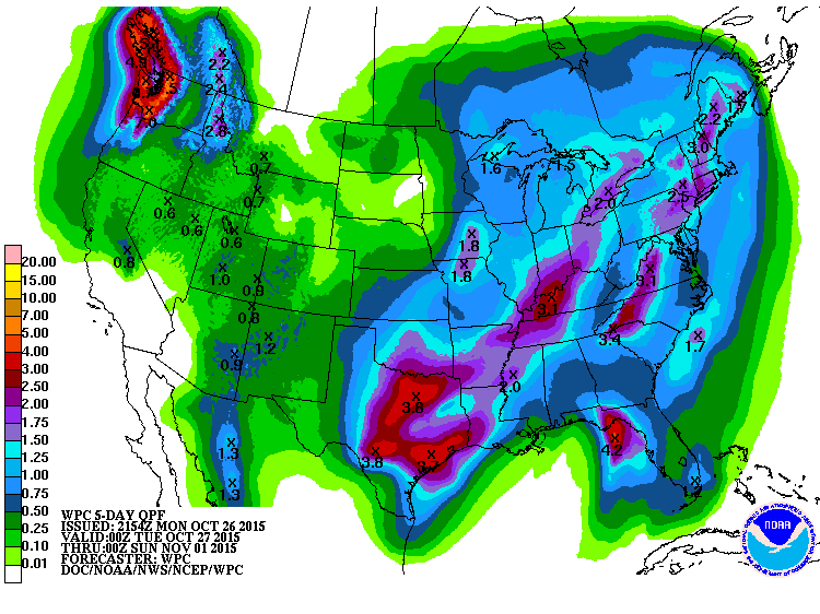
Heavy Southern Rains
Take a look at the 5 day radar estimated rainfall over the Southern U.S. and note the heavy rains over eastern Texas and parts of the Lower Mississippi Valley. One location in northeastern Texas saw more than 20" of rain!

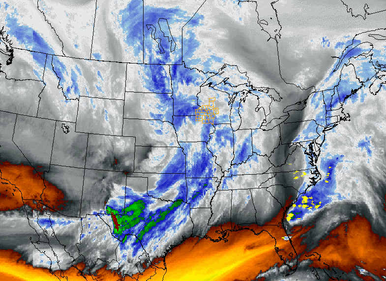
National Weather Outlook
The weather loop below shows the two storm systems coming together over the Upper Midwest/Great Lakes and intensifying. Heavier rain will be found along and east of the Mississippi River Valley, while some light snow could develop on the backside of the low with some minor accumulations possible close to the international border.
5 Day Precipitation
According to NOAA's WPC, the 5 day precipitation forecast suggests heavier moisture across parts of the eastern U.S. and another heavier blob in the Pacific Northwest as another storm system moves in.
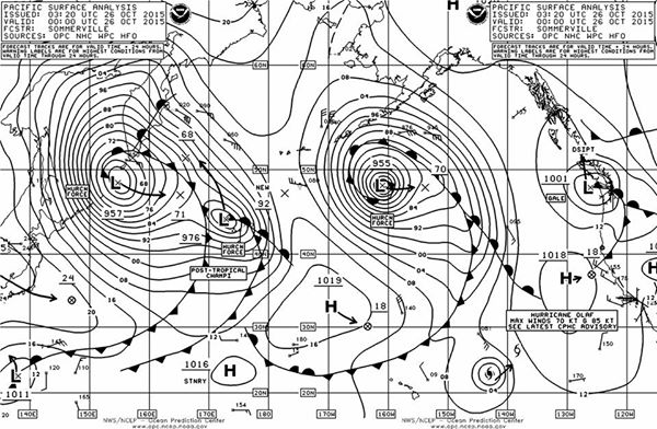
Stacked Lows in the Pacific
Here's an interesting picture/post from the NWS OPC showing how active the Pacific Ocean is right now. Note the huge storms across the Northern Pacific:
"Wow! Four systems with hurricane force winds in the Pacific basin, three extra-tropical and one tropical (Olaf). Natures way of balancing the earth heat/energy budget"
See more from the NWS OPC Facebook Page HERE:
_________________________________
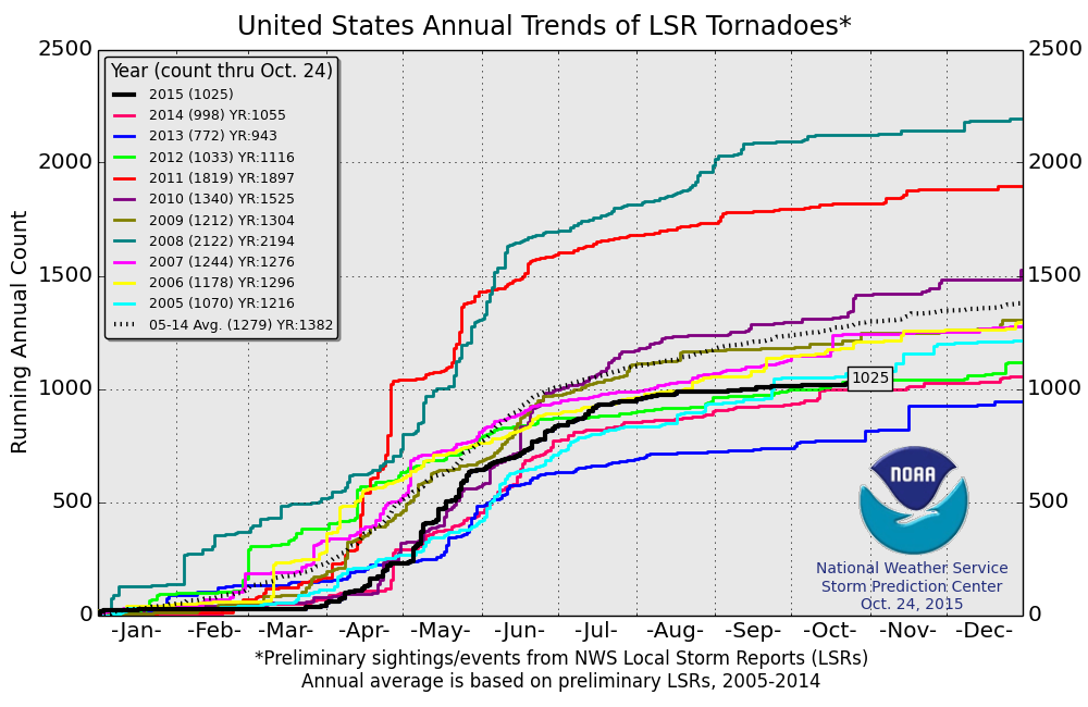
2015 Tornado Reports
According to NOAA's SPC, the PRELIMINARY 2015 tornado report suggests that there have been a little more than 1,000 tornadoes across the nation so far this year. Interestingly, this isn't too far off of the 2005-2014 short-term average, which is 1,279 through October 24th.
Thanks for checking in and have a good rest of your week. Don't forget to follow on Twitter @TNelsonWX

No comments:
Post a Comment