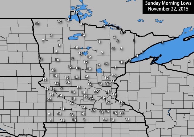
It was another cold start across the state Sunday morning, with temperatures starting off at 17 here in the Twin Cities. The coolest temperatures across the state were seen in northeast and southwest Minnesota. For airport locations, the coldest spot in the state was up in Hibbing, which reached a low of 0. Ely and Luverne both hit a low of 1, and International Falls dropped to 2.
Meanwhile, temperatures did drop below zero in spots in northeast Minnesota. The overall coolest temperature was -6 in Brimson. The next closest was in Cotton and Togo, both of which dropped to -1.
Warmer Weather To Start Monday
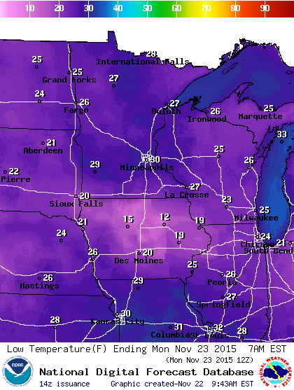
While it'll still be cooler than it has been in the mornings most of the month so far, it will be a warmer start on Monday with temperatures just below freezing in the Twin Cities. Otherwise, expect to see widespread 20s across the state to being the shortened holiday work week.
Possible Thanksgiving Mess - Rain And Snow Likely
By DJ Kayser, filling in for Douglas.
Thanksgiving weather can be fickle across the Twin Cities. Doesn't that come with the territory of it being a holiday? We see accumulating snow about once every five Thanksgivings, but rain can also occur. The most rain to ever fall on Turkey Day was back in 1896, when 1.76” fell. That was part of a two day event that brought the area 2.73” of liquid.
Moisture will be streaming into the upper Midwest ahead of a cold front for the middle of the week, bringing with it a chance of a Thanksgiving mess to Minnesota. It’ll start off as all rain Wednesday and Wednesday Night before becoming a mix of rain and snow for Thursday. However, it may be all snow Thursday as close as the St. Cloud area. In the Cities we’ll transition to all snow Thursday evening as cooler air works in before the system moves out early Friday. There is still uncertainty in the forecast, so stay tuned for the latest.
Until then, we'll see above average temps return to the map for the next few days with highs in the low 40s - not bad for late November!
SUNDAY NIGHT: Clearing skies. Winds: SW 10-15. Low: 30.
MONDAY: Back to the 40s with sun. Winds: NW 10. High: 40.
TUESDAY: Another mild, sunny late November day. Winds: SE 5-15. Wake-up: 27. High: 41.
WEDNESDAY: Cloudy AM. Afternoon rain moves in. Winds: S 5-10. Wake-up: 31. High: 43. Chance of precipitation: 30%.
THURSDAY: Thanksgiving. Mix of rain and snow. Winds: N 10-15. Wake-up: 34. High 37. Chance of precipitation: 80%.
FRIDAY: Snow tapers off early. Mostly cloudy. Winds: NW 10-15. Wake-up: 25. High: 28. Chance of precipitation: 20%.
SATURDAY: Cool start. Mainly sunny skies. Winds: SW 5-10. Wake-up: 17. High: 31.
SUNDAY: Sunny with highs around freezing. Winds: W 5-10. Wake-up: 23. High: 31.
This Day in Weather History
November 23rd
2003: New London and Little Falls both receive 9 inches of new snow.
1983: Heavy snowfall accumulates over most of central Minnesota with snowfall totals from 4 inches to almost 1 foot. Minneapolis received 11.4 inches of snow, while Farmington had 11 inches.
1954: Very strong winds over Minnesota lead to considerable damage in downtown Wadena.
Average High/Low for Minneapolis
November 23rd
Average High: 37F (Record: 55F set in 1905)
Average Low: 22F (Record: -6F set in 1898)
Sunrise/Sunset Times for Minneapolis
November 23rd
Sunrise: 7:21am
Sunset: 4:38pm
*Daylight: ~9 hours and 17 minutes
*Daylight Lost Since Yesterday: ~2 minutes and 1 second
A Wet November So Far
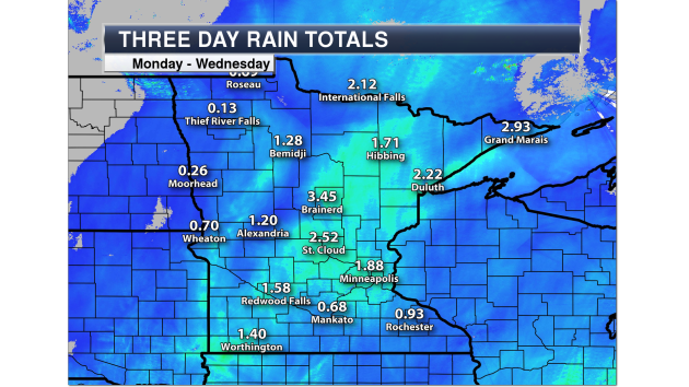
This November has been a wet one across the state of Minnesota - and it's mainly come in the form of rain for many. This is a look back at the three day rain totals from Monday through Wednesday last week. Almost three and a half inches of rain fell in Brainerd, while here in the Twin Cities we picked up just under two inches. (Image via D.J.'s Weather Blog)
Many rain records were set across these three days, according to Mark Seeley over at the Minnesota Climatology Office. Some of those included:
For November 17th: 1.07" at Rosemount, 1.00" at Vesta, 1.21" at MSP Airport, 0.79" at Ely, 0.60" at Pipestone, 0.67" at Minneota, 1.02" at Brainerd, and 0.87" at Bricelyn
For November 18th: 0.98" at St Cloud, 1.03" at Hawley, 1.18" at Worthington, 1.06" at Windom, 1.20" at Montevideo, 1.10" at Dawson, 1.26" at Milan, 1.45" at Collegeville, 1.69" at Milaca, 1.57" at Mora, 1.33" at Isle, 1.38" at Brainerd, 1.80" at Pine River Dam, 1.48" at Grand Portage, and 1.10" at Hastings.
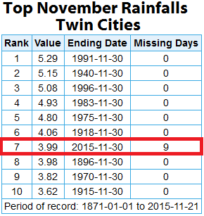
With the 3.99" of precipitation so far this month at the Twin Cities airport, we are sitting in seventh place for the wettest November on record. There is a good chance we could add to that later this week, likely helping us climb further in the ranks. And to think it's all pretty much been in the form of rain!
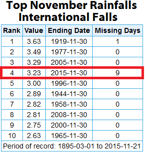
Another area that is sitting high in the November precipitation ranks is International Falls. They have seen 3.23" of liquid through Saturday (this doesn't include any melted liquid from Sunday snow). That ranks them fourth in all-time November precipitation, and they don't need that much more to go for the number one spot! We'll have to see where the weather this week gets them to.
Monday Weather Across Minnesota
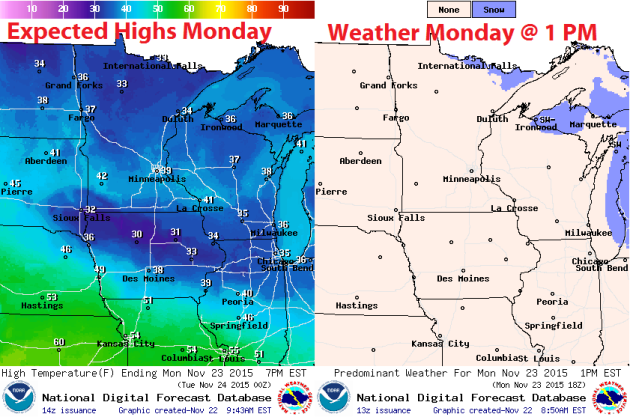
On the back side of the warm front, temperatures will be warmer across the state Monday. Highs will range from the lower 30s up north to the upper 30s and low 40s across much of central and southern Minnesota. The only areas that will likely buck that trend are those in extreme southern Minnesota that saw snow Friday. They will likely stay only in the low to mid 30s for highs.
As for cloud cover, I'm expecting more sun than clouds over the Twin Cities and southern Minnesota, with mainly cloudy skies as you head north. While much of the state remains dry, there will be a light snow chance along the Canadian border.
National Weather Outlook
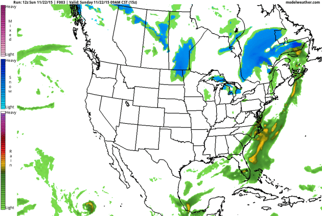
A period of rain is possible for parts of the Northeast through Monday morning, with snow in parts of Maine, as a low pressure system spins up and moves offshore. The clipper affecting parts of the upper Midwest Sunday will continue off to the east, bringing rain and snow to parts of Michigan Monday and into New York Tuesday. Meanwhile, a new storm system will move into the western U.S. into the beginning of the week, bringing much needed rain and snow to the region.
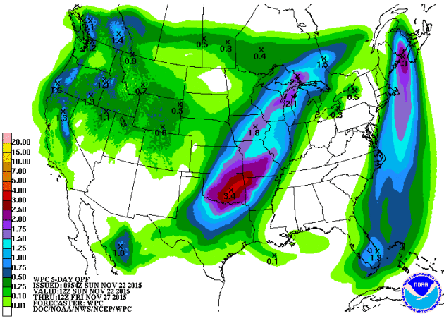
The five day precipitation outlook shows the heaviest over the central part of the nation, including into southern Minnesota and much of Wisconsin. Over three inches will be possible in parts of Oklahoma.
Thanksgiving Storm Looms
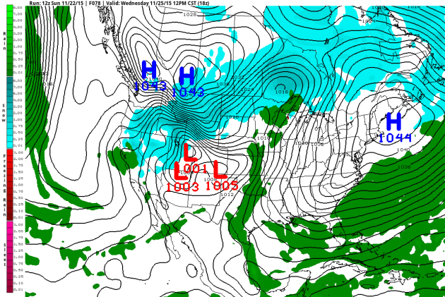
The system we've been watching for Thanksgiving is still on track to affect us in the upper Midwest. It'll start here in the Cities during the day as rain or drizzle, and continue into Wednesday night.
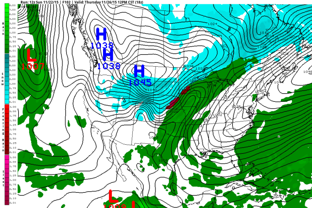
As we get into Thanksgiving, we'll see a rain and snow mix start taking over the region, with pretty much all snow just up I-94 in St. Cloud. As the big switch over to all snow occurs in the Cities Thursday afternoon or evening, a period of sleet or freezing rain could be possible before snow takes over and tapers off into Friday morning.
While we are tracking this system, please note that there is still some uncertainty with the storm - particularly where the precipitation will be (especially how west it goes). We'll continue to watch the trends and update over the next few days. Either way, it looks like there could be travel impacts as we head into the holiday.
Past Thanksgiving Weather
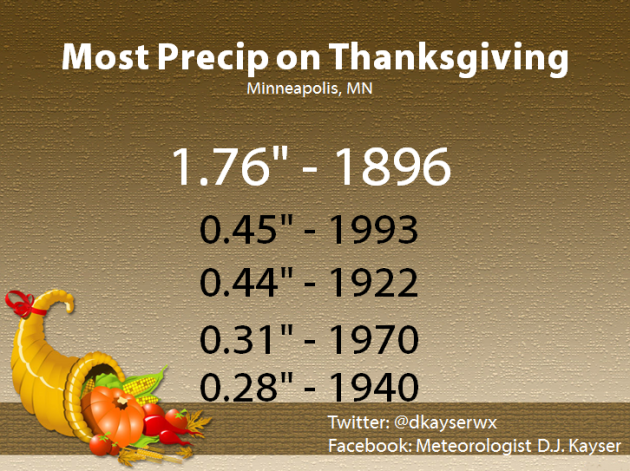
A little over one in four Thanksgivings see some form of precipitation, whether it's in the form of rain or snow. This list shows the Thanksgivings with the most precipitation (rain or melted snow). The only time more than an inch of precipitation fell was back in 1896, when 1.76 inches of rain fell. That was part of a two day event that brought the area 2.73 inches.
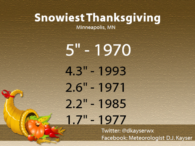
Meanwhile, about every five years we see snow fall and accumulate. The most ever on Thanksgiving Day was back in 1970 with 5 inches falling. Last year 0.3" fell on Thanksgiving.
Thanks for checking in and have a great holiday week! Don't forget you can follow me on Twitter (@dkayserwx) or on Facebook (Meteorologist D.J. Kayser)!
- D.J. Kayser

Thanks for sharing such an informative blog post, I like it. I love rain and love to read Rainy Day Quotes.
ReplyDelete