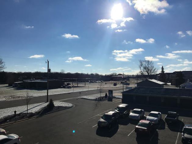
Brr! This was the view Saturday morning from the St. Cloud area, where the morning low was a chilly 11 degrees. There was still enough snow to coat the ground in parts of central Minnesota, left over from the band that moved through central Minnesota Thursday. That dumped a half an inch that morning, the most they've seen this season so far - and much more than the Twin Cities has seen.
The coldest air of the season so far has moved into the region over the past few days, filtering in behind the departing snowstorm to our south. Temperatures dropped to 16 at the Twin Cities airport, the coolest morning since March 6th (which saw a low of 7 degrees).
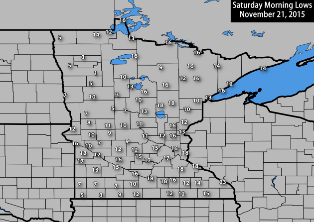
The coolest air was found in northwest Minnesota, where the coldest temperature (at an ASOS/AWOS station) was recorded at Fosston - plummeting to a morning low of 1. Elsewhere across northern Minnesota, Park Rapids and Thief River Falls dropped to 3. Hallock, Wadena, and Crookston fell off to 5 Saturday morning.
It was also a quite chilly start in southwest Minnesota, where snow fell on Friday. Those in Worthington had the coolest temperature in this part of the state, waking up Saturday morning to a temperature of 3 degrees. Luverne dropped to 5 degrees, and a trio of cities work up to a temperature of 7: Windom, Pipestone and Slayton. We'll have more on how much snow fell later on in the blog.
Sunday Morning Wake Up Temperatures
We're expecting another very chilly start across the region Sunday morning. If you're heading out early to church or for any other Sunday activities (like tailgating) make sure you have that warm jacket on! Temperatures here in the Twin Cities will be around where they were this morning, but single digits can be expected across southern Minnesota and into Iowa in the areas where snow fell. As you head into Iowa, there could even be a few locations flirting with single digits below zero Sunday morning.
Turning Warmer – Rain And Snow For Thanksgiving
By DJ Kayser, filling in for Douglas.
Enjoying the cooler weather? While the first winter storm of the season for parts of the upper Midwest passed to our south Friday and Saturday, we've been left with the coolest weather of the season so far in the Twin Cities. While I don't think I have to tell you November has been a warm month, Saturday was only the second day so far this month with an average temperature that was below average.
Don’t fret, though, as warmer weather does return this week. After another chilly start Sunday morning, temperatures will climb into the 30s for highs. Clouds will be on the increase as a clipper passes to our north, with the north shore in line for a quick couple inches of snow. Highs will warm back into the 40s for the beginning of the work week – once again above average.
As we head into the holiday, however, the weather turns turbulent. A cool front will be on the move, and even though uncertainty remains in the overall evolution of the system, rain and snow is likely across the state for Thanksgiving travelers Wednesday and Thursday.
SATURDAY NIGHT: Increasing clouds. Winds: SE 5. Low: 18.
SUNDAY: Cloudy skies. Snow across northern Minnesota. Winds: SW 10-15. High: 34.
MONDAY: Sunny. Highs back above average. Winds: NW 5-10. Wake-up: 28. High: 40.
TUESDAY: Mild and sunny. Winds: SE 5-10. Wake-up: 26. High: 42.
WEDNESDAY: Rain moves in midday. Winds: SE 5-10. Wake-up: 32. High: 43. Chance of precipitation: 30%.
THURSDAY: Turkey Day. Rain chances to snow late. Winds: N 10-15. Wake-up: 35. High 38. Chance of precipitation: 80%.
FRIDAY: Snow tapers off early. Cloudy skies. Winds: NW 10-15. Wake-up: 24. High: 30. Chance of precipitation: 30%.
SATURDAY: Sunshine returns. Cooler conditions. Winds: NW 10-15. Wake-up: 14. High: 28.
This Day in Weather History
November 22nd
1996: Heavy snowfall accumulates over the same areas that were hit two days earlier. Four to seven inches of snowfall are reported across the area. Heavier snowfall occurred during the daylight hours of the 23rd. Snowfall totals of six inches were reported in the Twin Cities, Chanhassen, Stewart, St. James and Redwood Falls.
1970: Gale-driven snow falls across Minnesota. 45 mph winds are reported over Rochester and Duluth.
Average High/Low for Minneapolis
November 22nd
Average High: 37F (Record: 60F set in 2012)
Average Low: 23F (Record: -6F set in 1880)
Sunrise/Sunset Times for Minneapolis
November 22nd
Sunrise: 7:20am
Sunset: 4:39pm
*Daylight: ~9 hours and 19 minutes
*Daylight Lost Since Yesterday: ~2 minutes and 4 seconds
Southern Minnesota and Midwest Snow
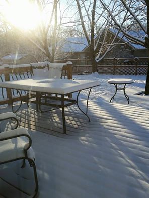
This was the scene that parts of southern Minnesota woke up to Saturday morning - a fresh coating of snow! Thanks to my friend - and fellow SCSU meteorology alum Kyle Schanus - for taking this picture in Austin, MN.
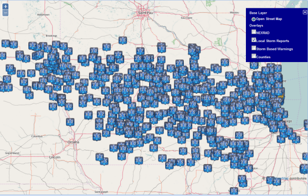
Here is a look at the snow totals that came in from Friday/Friday Night across southern Minnesota. Most saw 2-4", but there were a few totals that stood out:
- 8.0" - 2 miles NNE of Worthington
- 4.4" - Luverne
- 4.0" - 1 miles NE of Fairmont
- 4.0" - Round Lake
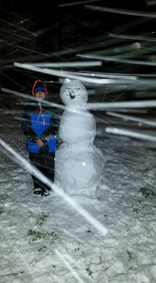
Meanwhile, you go south of Minnesota and there was almost a guarantee you had enough snow to build a snowman. My uncle Doug Kayser took this picture Friday Night in Ankeny, IA of one of those freshly built snowmen.
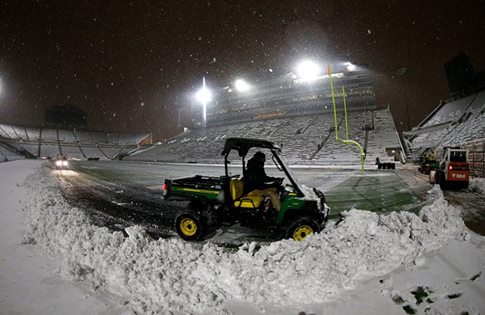
Over in Iowa City, IA, these were the groundskeepers at the University of Iowa, working on clearing Kinnick Stadium Friday night ahead of the Hawkeyes football game versus Purdue. They got the field clear in time, but as I was watching parts of the game Saturday I noticed that there was still snow on the seats in parts of the stadium - apparently it was up to the fans to clean off their own seat! (Photo Credit: Iowa Hawkeyes on Facebook)
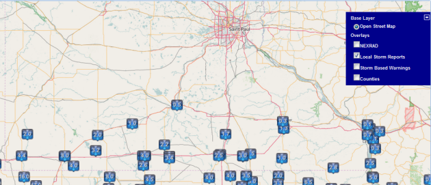
Here's a look at the storm reports from South Dakota eastward toward Chicagoland showing a wide range of totals, tapering off quickly (for the most part) on the north and south sides of the snow swath.
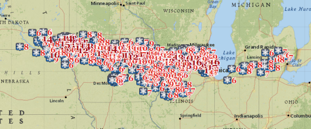
These are just the reports of 6" or more to help show where the heaviest snow fell - in a band from Sioux Falls across northern Iowa and northern Illinois toward Chicago. A secondary heavy band went south of there through the Quad Cities toward Peoria.
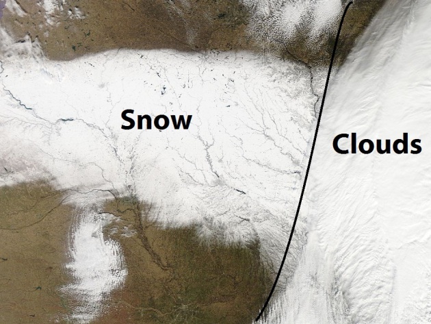
This was the view from the MODIS satellite across the upper Midwest Saturday midday showing snow on the ground across portions of South Dakota, Nebraska, Minnesota and Iowa. Off to the east - that was cloud cover as the storm was still impacting parts of eastern Iowa and into Illinois at the time this was taken.
Sunday Weather Across Minnesota
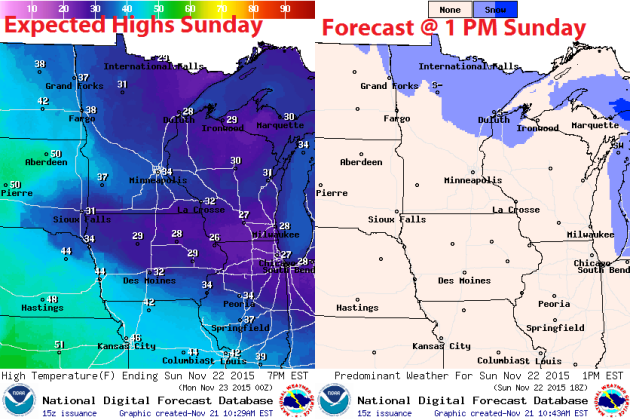
Temperatures will be warmer Sunday than Saturday as a warm front moves through the state. A few snow showers will be possible across northern Minnesota, where the best forcing will be as that warm front moves though and a clipper system moves across the Great Lakes.
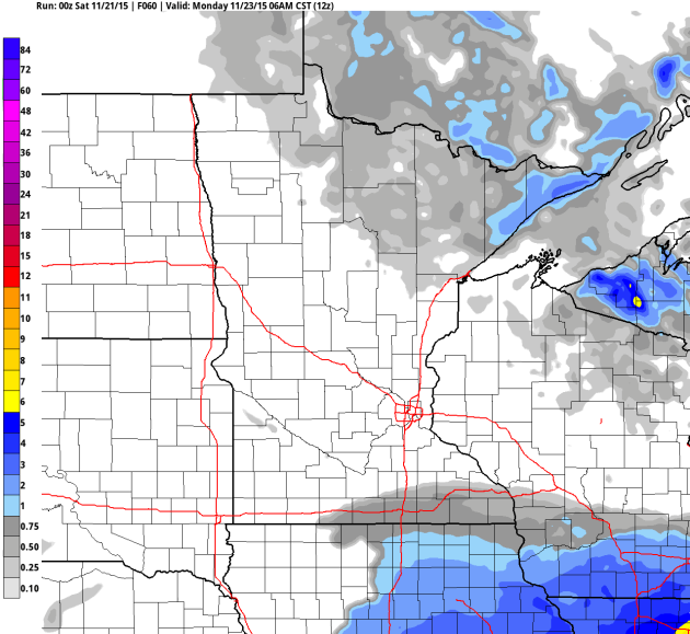
Snow shouldn't make it as far south as the Twin Cities, but some accumulation in possible across parts of northern Minnesota, especially along the north shore of Lake Superior - mainly north of Two Harbors. In those areas, up to three inches are possible Sunday and Sunday Night. Graphic: Forecast snow total through Monday morning.
Vikings Forecast
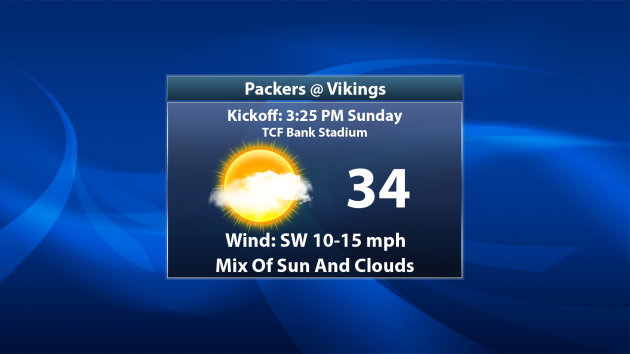
Temperatures will be a bit warmer Sunday for the border battle Vikings/Packers than they were on Saturday. Highs will reach into the mid 30s in the afternoon hours with a mainly cloudy sky. There will likely be peaks of sun, however. Of course, I root for the purple and gold - so Skol Vikings!
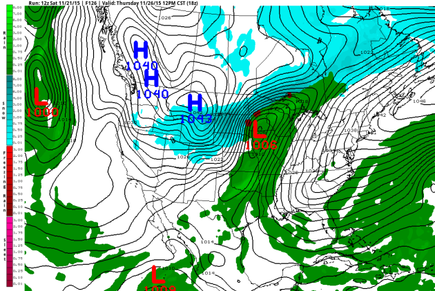
National Weather Outlook
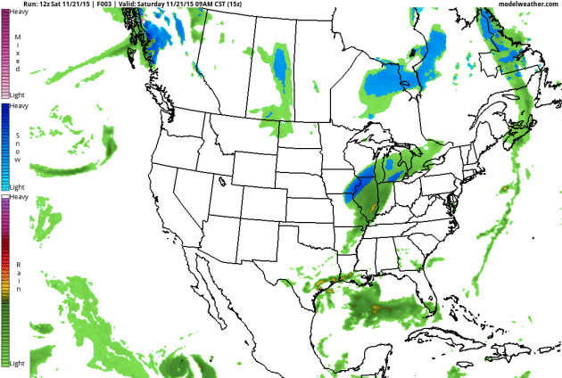
As we take a look at the forecast across the nation the next few days, we can see the clipper system that moves through the Great Lakes, bringing a shot of snow to northern Minnesota. A leftover front helps to bring a chance of rain to much of Florida - parts of the panhandle are in a moderate drought, so the rain is certainly welcome, even if it comes on a weekend. The snowstorm that passed to our south and brought Chicago and Michigan heavy snow Saturday continues to move off into Canada, but brings parts of the Northeast a chance at some rain early Sunday. The next storm system to impact the nation starts moving into the west as we enter the work week, and this could have a large impact on Thanksgiving holiday travel.
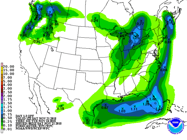
The heaviest precipitation over the next couple days will be across portions of Florida, again where that front lingers. The northwest continues to get some appreciated precipitation as they try and inch away front drought status. Meanwhile, much of the southwest and Plains will remain dry though Tuesday morning.
Thanksgiving Storm Looms
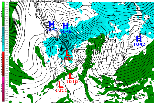
As an area of low pressure tries to move off the Rockies, and a cool front approaches, rain will spread across the area during the day Wednesday. About the only area of the state that doesn't look warm enough for rain right now would be northern Minnesota, where snow will likely be the predominant precipitation from this storm.
Taking a look at the model for Thanksgiving afternoon, right now the models keep us warm through much of the day Thursday. That would be enough to keep it mainly rain for the holiday, though with the potential of some sleet mixing in at times. As of today's model runs, we will see the front moves east into Thursday night, bringing a potential wintry mix to the region before turning to all snow during the night and into Friday.
* The important part to note here is that we are still a number of days away from this event, and there is still uncertainly in the models with how this system evolves. That does prove an issue with what mode the precipitation will be in - rain, wintry mix, or snow. What we can pretty well be certain on is that there is the potential of heavy precipitation across the region Wednesday into Thanksgiving. What we can also be certain of is there could be a number of travel delays across the eastern half of the nation due to rain and snow. Stay tuned over the next few days - we will continue to refine the forecast as it gets closer!
Thanks for checking in and have a great rest of your weekend! Don't forget you can follow me on Twitter (@dkayserwx) or on Facebook (Meteorologist D.J. Kayser)!
- D.J. Kayser

No comments:
Post a Comment