Thursday was the first time that the temperature dropped to 30 degree here in the Twin Cities. Technically the low for the day (of 30 degrees) was set at 1:16 PM! This marked the latest first 30 degree day in recorded history for the Twin Cities, shattering the previous record set November 10th of 2005. The earliest occurrence? September 20th, 1883.
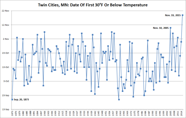
We also technically broke the record for first sub-30 degree temperature here in the Twin Cities by finally dropping below 30 Friday morning. The previous record had been set November 19th of 1922.
Snowy Mess In Sioux Falls, SD And Northern Iowa
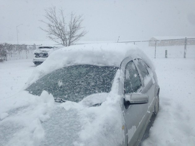
Be glad you are missing out on this! Thanks to my friend - and fellow SCSU meteorology alum - Brian Kirk for this photo of a lot of snow in Sioux Falls around 11 AM Friday. He said his dog was having fun in the snow once he got home from work – meanwhile, he was just staring at his driveway, trying to figure out how to start tackling the task at hand. (Give him a follow on twitter: @BrianKirkWX)
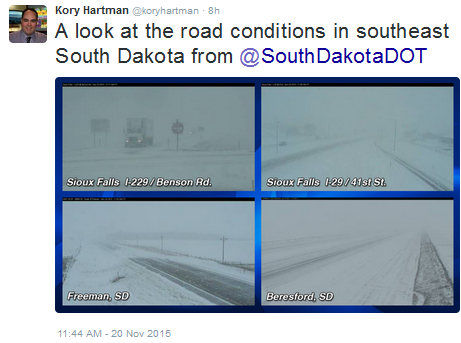
Travel was rough as snow quickly accumulated on the roads. Some of the roughest travel was on the southern side of town.
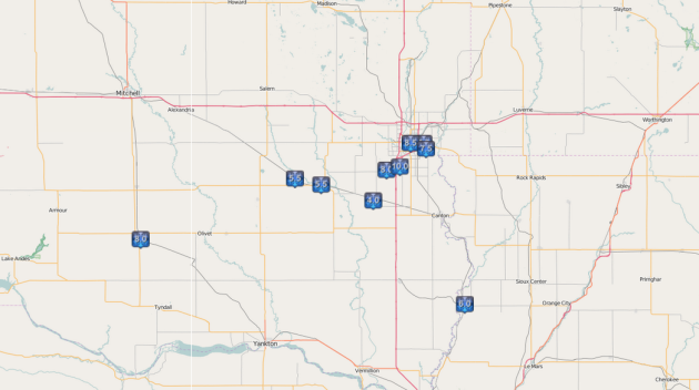
Already through noon there had been reports of 8-10" of snow just south of Sioux Falls near Tea, SD as a heavy band set up across the region. The National Weather Service in Sioux Falls made a note around noon there was a sharp drop in the snow totals across the region, with 10-12" south of the city, 4" at the airport and barely an inch north of town.
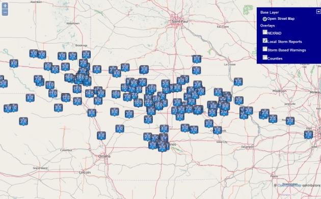
This was a look at snow totals reported to the National Weather Service through 7:30 PM Friday evening. The snow continued to pile on in southern Sioux Falls since noon, with 18" being the largest total reported one mile southeast of Tea, SD. The official reporting station in Sioux Falls (the airport) reported 7.2" of snow on the ground as of 6 PM. Numerous other 10"+ reports can be seen across parts of northern Iowa, including 13" in Renwick and 10" in Pocahontas. Some snow did accumulate in southern Minnesota, with the largest total being 4.4" in Luverne.
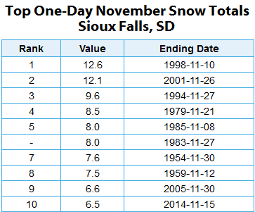
With the 7.2" through 6 PM Friday, Sioux Falls was able to break into the top ten snowiest November days on record - placing them in ninth. The most ever to fall in one November day at the Sioux Falls airport was back on the 10th of 1998 when 12.6" accumulated in town.
Heavy Snow Passes South Of Us
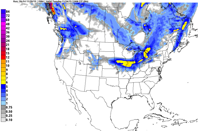
That heavy snow will continue to move east into the day Saturday, staying south of Minnesota. We are still looking at a band of six or more inches (highlighted by the yellow area) from central Iowa through northern Illinois, including the Chicago area. Saturday the best chance of heavy snow will be northern Illinois into southern Michigan, including Detroit.
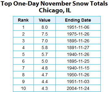
The last time Chicago saw over two inches on a November day was back on November 24th, 2004 when 4.3" fell. That became the tenth snowiest November day in Chicago history. We could easily break into the top ten here as we work through the day Saturday, with 3-6" of snow possible.
November-like Weekend Ahead, Thanksgiving Storm?
By DJ Kayser, filling in for Douglas
Cold. Snow.
Those are two words you typically associate with the month of November. Those are also two words that you *haven't* really been able to associate this November with yet! For example, Thursday was the first time Minneapolis saw a temperature of 30 degrees this season, the latest that has ever occurred on record going back to 1873. Meanwhile, we have yet to see a tenth of an inch of snow at the Twin Cities airport, the latest in the season since 2007.
Unfortunately, we have been jolted back to reality on the temperature front, thanks to the strong storm that came through earlier this week. While the sun may look warm today, you'll want to bundle up if heading out to the Gophers game as highs will only be in the 20s. Temperatures will warm back into the 30s Sunday for the Vikings and Packers game, and then the 40s early next week.
The next storm chance for southern Minnesota arrives mid to late next week. We'll have a close eye on it as it could bring a wintry mix just in time for Thanksgiving and Black Friday.
FRIDAY NIGHT: Decreasing clouds late. Winds: NW 5-10. Low: 22.
SATURDAY: A cold sun and clouds mix. Winds: NW 10-15. High: 27.
SUNDAY: More clouds. Snow in northern MN. Winds: SW 10-15. Wake-up: 20. High: 34.
MONDAY: Mild with sunny skies. Winds: NW 10-15. Wake-up: 27. High: 42.
TUESDAY: Another nice November day with sunshine. Winds: SE 5-10. Wake-up: 26. High: 41.
WEDNESDAY: Cloudy, rain/snow chance moves in late. Winds: SE 10-15. Wake-up: 31. High: 41. Chance of precipitation: 20%.
THURSDAY: Wintry mix for Thanksgiving likely. Winds: N 10-15. Wake-up: 34. High 36. Chance of precipitation: 50%.
FRIDAY: Lingering snow showers. Winds: NW 10-15. Wake-up: 16. High: 28. Chance of precipitation: 40%.
This Day in Weather History
November 21st
2001: Record highs are set in west and north central Minnesota, ranging from the upper fifties to lower sixties. Redwood Falls set their high with 68 degrees Fahrenheit and Little Falls had a high of 65 degrees.
1980: On this date, around 28 thousand Canadian geese spent their nights on Silver Lake in Rochester.
Average High/Low for Minneapolis
November 21st
Average High: 38F (Record: 67F set in 1900)
Average Low: 23F (Record: -11F set in 1880)
Sunrise/Sunset Times for Minneapolis
November 21st
Sunrise: 7:18am
Sunset: 4:40pm
*Daylight: ~9 hours and 21 minutes
*Daylight Lost Since Yesterday: ~2 minutes and 6 seconds
Saturday Weather Across Minnesota
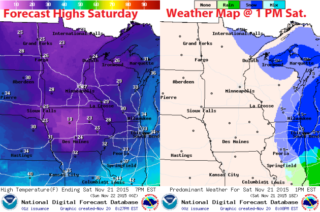
The coldest day of the season so far is on tap across the region, with highs only in the mid to upper 20 across southern Minnesota. Highs will be limited to the low 20s across northern Minnesota, where some snow is possible in the Arrowhead. You may notice we'll be warmer than Iowa, which will be held cooler due to the 6"+ of snow on the ground.
Gophers Forecast
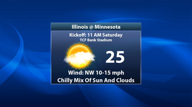
If you are heading out to the Gophers game Saturday morning at TCF Bank Stadium, make sure you bundle up! Temperatures throughout the game will only be in the middle 20s, but feel more like the low 20s. Winds will be out of the northwest at 10-15 mph.
Vikings Forecast
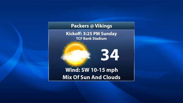
Temperatures will be a bit warmer for the border battle Vikings/Packers game on Sunday, with temperatures in the lower to mid 30s with a few more clouds in the sky. Of course, I root for the purple and gold - so Skol Vikings!
National Weather Outlook
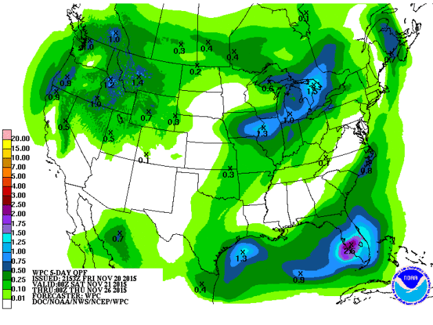
Potential Thanksgiving Storm?
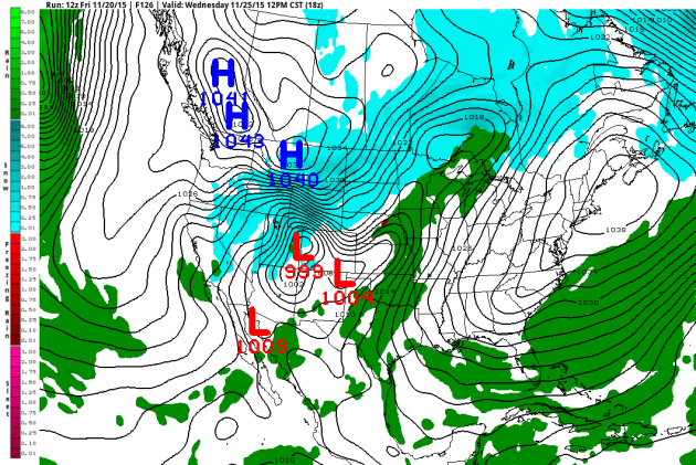
Everything comes together once again for another storm to hit at just the wrong time: a holiday. This time its Thanksgiving, and we'll be watching a cool front moving through the U.S., bringing the chance of rain and snow with it. Above is a model depiction of weather for Wednesday around noon, already bringing a chance of rain here into the Twin Cities and snow to parts of northern Minnesota. If you're traveling west Wednesday, expect some delays in travel. Some central and western U.S. airport hubs could experience delays due to rain and snow. Apparently Mother Nature will spare the east coast for the most part though, with New York City, Boston, Philadelphia and other under high pressure - no weather causing delays there.
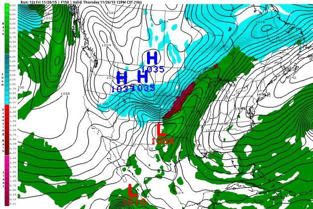
We will have to watch this storm closely, as the models are hinting at a period of freezing rain or sleet as we head into Thanksgiving from the Twin Cities southwestward toward northern Kansas that could quickly snarl those going over the river and through the woods. Snow looks to spread into Denver for the holiday, but once again the big hubs out east will remain dry. Of course, this could pose trouble for those heading out for Black Friday deals as well. Stay tuned - I can guarantee we will have more on this storm in the coming days.
Thanks for checking in and have a great weekend! Don't forget you can follow me on Twitter (@dkayserwx) or on Facebook (Meteorologist D.J. Kayser)!
- D.J. Kayser

No comments:
Post a Comment