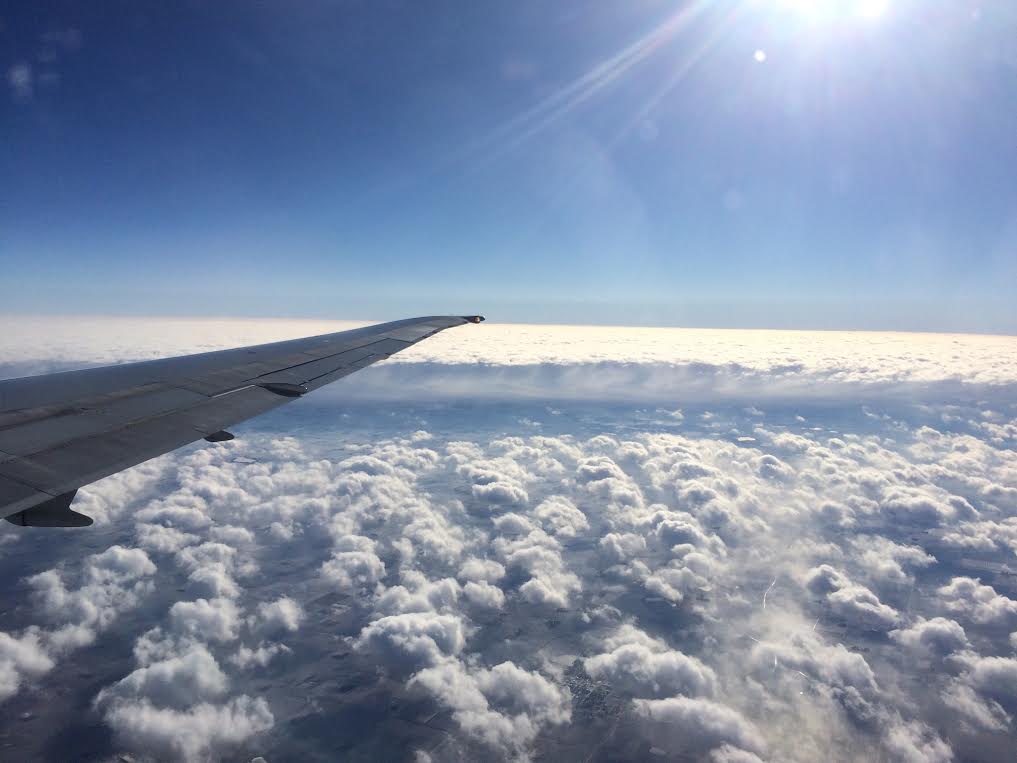
Thanks to Aaron Weidener for this neat picture, which shows the puffy cumulus clouds that were responsible for scattered snow showers/flurries around the region yesterday. Also note the larger open streak that stretches underneath the plane wing. Another descending plane through that particular cloud layer is likely responsible for that hole punch or fallstreak hole cloud.
Ho Ho Huh? 40F and Drizzly Rain on Christmas Day
By Paul Douglas
I went to school with Weather Channel meteorologist Mike Seidel, who by his count has logged 17,838 live weather shots during his on-air career. If a big storm is imminent chances are Mike will be near your zip code. When he's not on a plane he's hiding in his Atlanta weather bunker, where upper 70s are likely on Christmas with T-storms. I asked him what he tells baffled locals celebrating the warmth. "It's the transmigration of the circumpolar vortex!" he laughed. I think he's onto something. Perpetual spring continues across much of the USA, in fact most of the northern hemisphere is simmering. The coldest air is bottled up near the Arctic; frigid fronts running out of gas before reaching the USA.
A seasonably chilly Saturday gives way to 40F Sunday. After cooling off early next week we brush 40F by midweek; another chance of 40F Christmas Day with a little light rain. While much of the south and east sets new record highs. Uh...happy St. Patty's Day!
NOAA's GFS model hints at snow potential the Tuesday after Christmas. Until then the Faux-Winter of '15-16 limps on.
____________________________
Extended Forecast
FRIDAY NIGHT: Cold with a few lingering clouds. Winds: W 5-15. Low: 9.
SATURDAY: Partly sunny, "average". Winds: W turning SE 5-10. High: 28.
SATURDAY NIGHT: Some sun, another December thaw. Winds: SSE 10. Low: 27.
SUNDAY: Clouds increase, thawing out again. Winds: S 10-15. High: 41.
MONDAY: Flurries taper, slow clearing. Wake-up: 29. High: 34
TUESDAY: Overcast. Milder breeze kicks in. Wake-up: 27. High: 39
WEDNESDAY: Marchlike, risk of a passing rain/snow shower. Wake-up: 33. High: 38
THURSDAY: Flurries. Maybe a little PM sun. Wake-up: 20. High: 31.FRIDAY: Periods of light rain, slushy up north. Wake-up: 29. High: 39.
______________________________
This Day in Weather History
December 19
1983: Record lows are set across central Minnesota with temperatures ranging from fifty degrees below zero to the upper twenties below zero. Mora set their record with a low of 52 below, with 42 below at Little Falls, 41 below at Jordan, St. Cloud, and Cambridge, and 39 below at Long Prairie, Milaca, and Stillwater.
1923: Unseasonably mild temperatures occur in Minnesota. Temperatures climb into the 60s at New Ulm.
_______________________________
Average High/Low for Minneapolis
December 19th
Average High: 26F (Record: 52F set in 1923)
Average Low: 11F (Record: -11F set in 1983)
_______________________________
Sunrise/Sunset Times for Minneapolis
December 19th
Sunrise: 7:46am
Sunset: 4:33pm
*Daylight lost since yesterday: ~14 seconds
*Daylight lost since summer solstice (June 21st): ~6 hours and 50 minutes
_________________________________
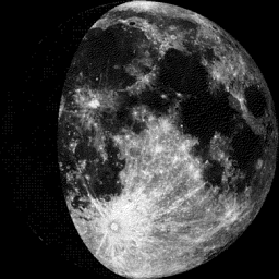
Moon Phase for December 19th at Midnight
1.7 Days Since First Quarter
_____________________________________
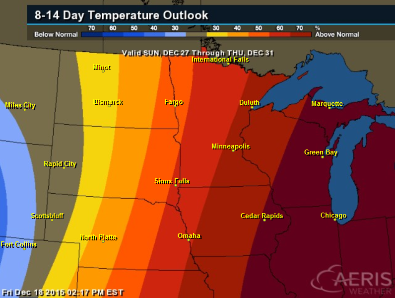
8 to 14 Day Temperature Outlook
According to NOAA's CPC, the 8 to 14 day temperature outlook still suggests warmer than average temperatures across parts of the Midwest and Great Lakes Region through by the end of the month.
__________________________________
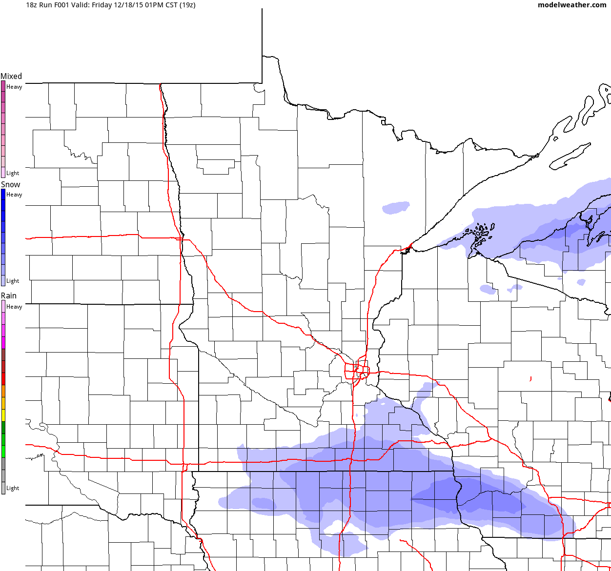
Simulated Radar
A brief stint of wintry weather will give way to warmer tempratures once again by late weekend as temperatures warm to near 40F by Sunday. However, a wintry mix may develop across the northern part of the state late weekend as temperatures hover near the freezing mark.
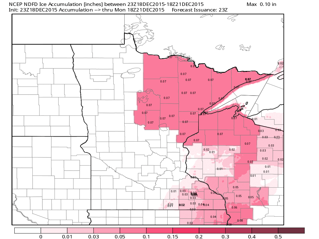
Minnesota Icing Potential
A wintry mix will be possible late weekend with a chance of light icing across the northeastern part of Minnesota and parts of Wisconsin.
5 Day Precipitation Outlook
According to NOAA's HPC, the 5 day precipitation outlook suggests fairly light amounts through the middle part of next week.
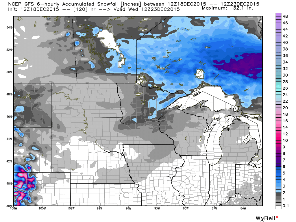
5 Day Snowfall Potential
Here's the GFS 5 day snowfall potential, which doesn't bring us anything significant in the snowfall department through midweek. However, a few locations across central and northeastern Minnesota could get in on a few light shoveling tasks.
_______________________________
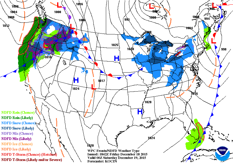
National Weather Outlook
Active weather conditions in the Western U.S. will translate into somewhat acitve weather conditions in the Central U.S. by late weekend. However, warmer temperatures will keep much of the moisture in the Central U.S. in the form of liquid rather than snow or wintry precipitation.
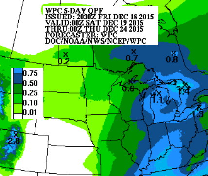
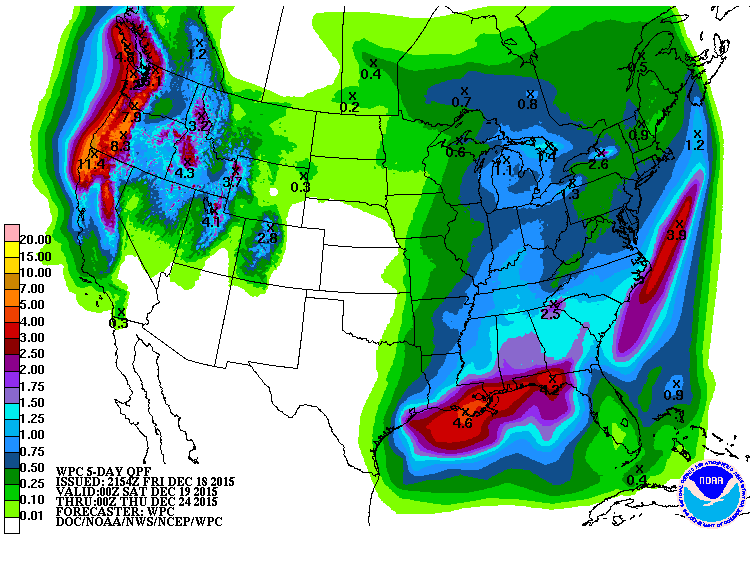
5 Day Precipitation Outlook
According to NOAA's WPC, the 5 day precipitation outlook, the heaviest moisture will be found across parts of the Gulf Coast States and once again across the Pacific Northwest.
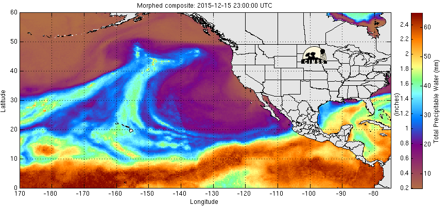
Pacific Precipitable Water Loop
Waves of Pacific moisture continue to push into the Western part of the country. Each wave that hits brings more heavy rain/snow to the Pacific Northwest.
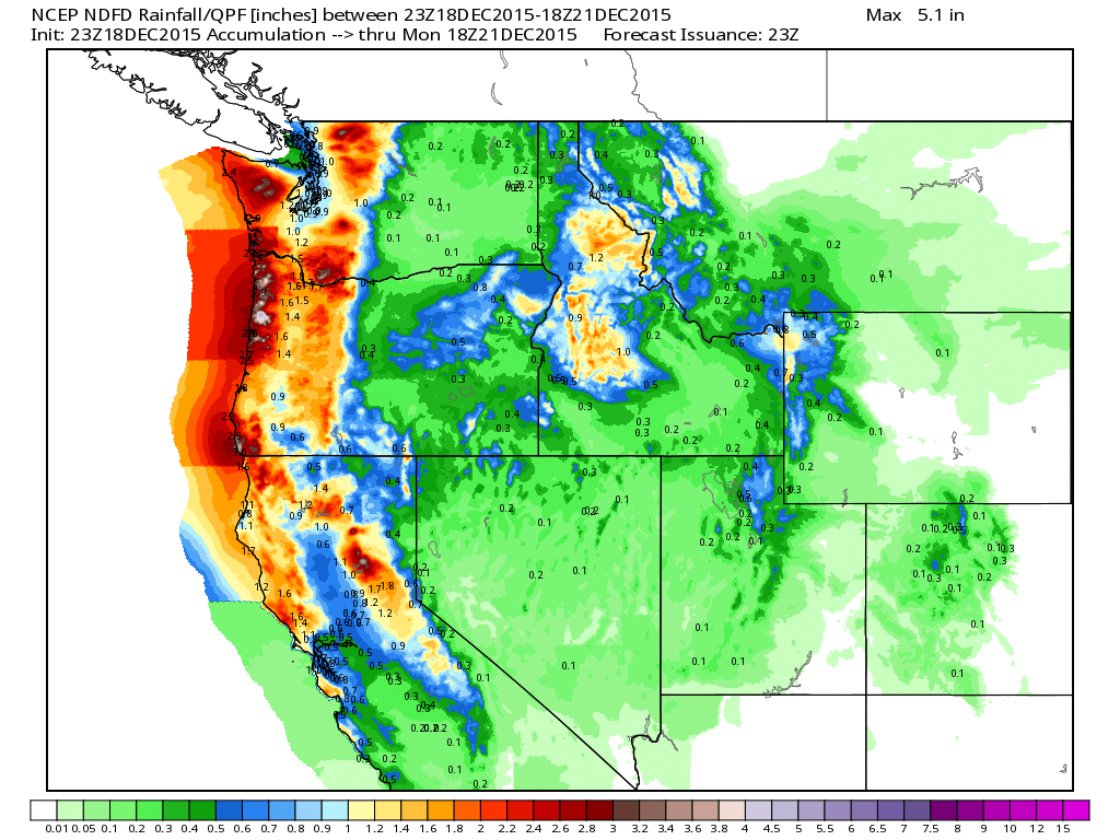
Northwest Precipitation
Precipitation values in the Pacific Northwest continue with an additional 1" to nearly 3"+ possible through midday Monday
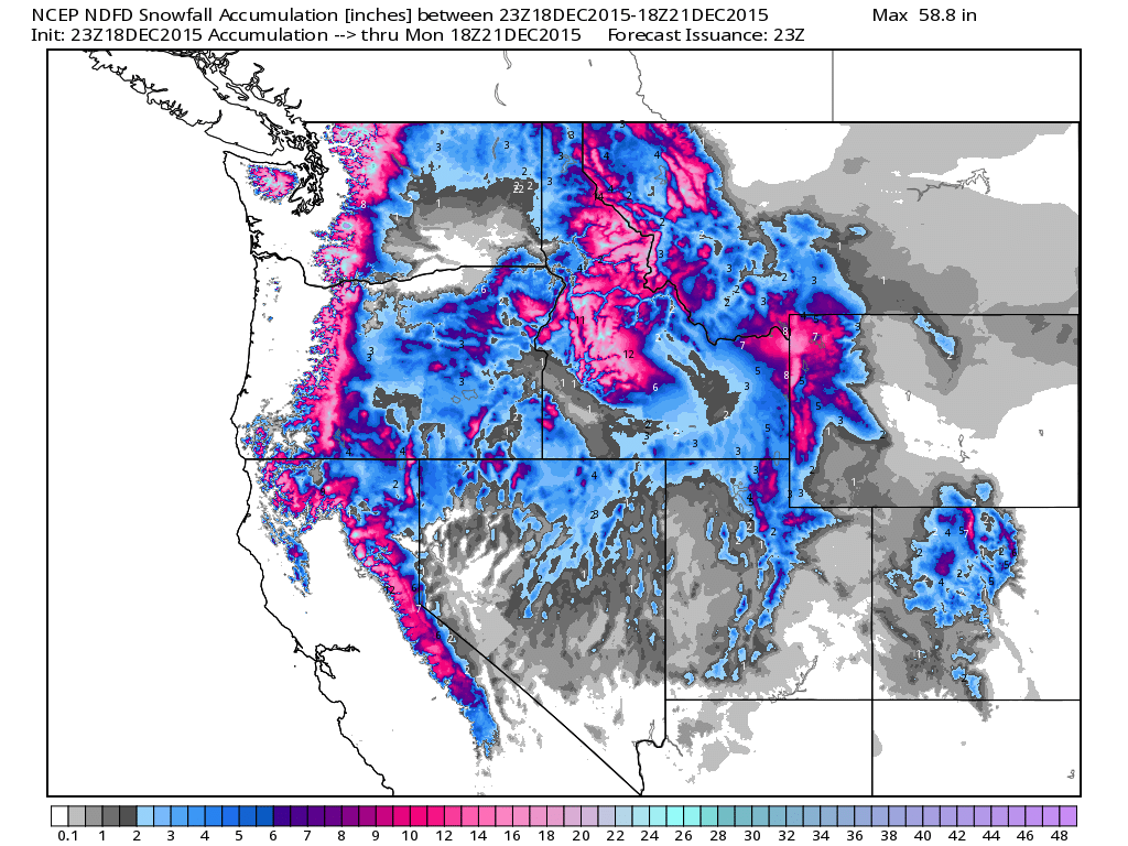
Northwest Snowfall
Snowfall tallies through midday Monday will be quite impressive with some spots seeing nearly a foot or more across parts of the Cascades and Northern Rockies.
______________________________________
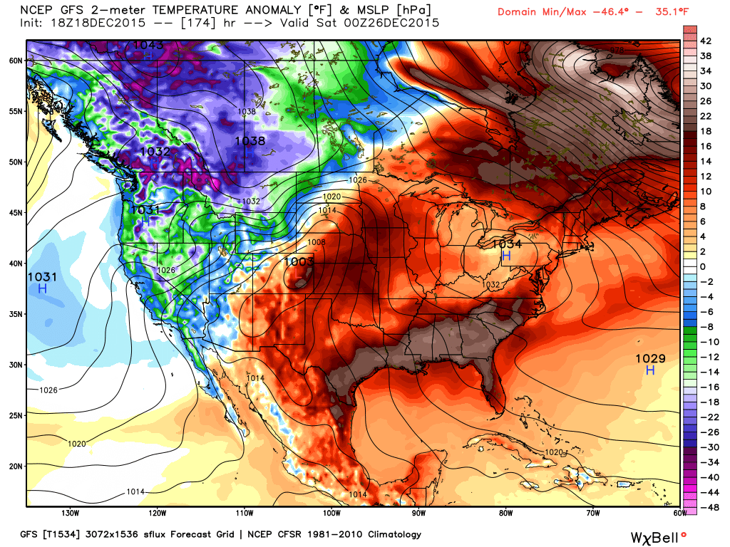
Christmas Warmth
Temperature anomalies on Christmas day next Friday suggest much warmer than average temperatures across the eastern half of the country, while cooler than average temperatures will be found in th western half of the country.
_______________________________
11 Things You Learn When You're a Weatherman for a Day
"Some people work for a paycheck, while others work because they genuinely love what they do. In my time at NBC, I really learned that when you work with weather, you’re firmly entrenched in the latter category. And you HAVE to be. With crazy hours, the high stakes of producing and appearing on a live broadcast, and the pressure of serving hundreds of thousands of viewers, being a meteorologist is so much more than just showing up for your shift."
"11. But the most important thing I learned was that being a weatherman is one of those jobs that requires you to be really, really passionate about your work."
Here's the story from buzzfeed.com
___________________________________
Is China Finally Follwing It's Own Climate Rules?
"(CNN)China has issued its second ever "red alert" warning, advising residents that heavy air pollution is anticipated to shroud northern parts of the country this weekend. The bad air quality is predicted to last until Tuesday and will again directly impact the capital, Beijing. Time-lapse video shows smog-stricken Beijing Time-lapse video shows smog-stricken Beijing 01:50 The notice comes hard on the heels of last week's red alert warning -- the first ever -- when the Air Quality Index (AQI) reached 250, 10 times higher than the World Health Organization's recommended levels."
See the full story from CNN.com HERE:

_________________________________
Thanks for checking in and have a great weekend ahead! Don't forget to follow me on Twitter @TNelsonWX

This article helps parents encourage their children in piano lessons to try new pieces of music, and enjoy the rewards of achieving consistent, long-term piano growth. No matter what he does, he wakes up the next morning and it is once again Groundhog Day. This continues until he decides to learn and grow. Only after he begins focusing his efforts on helping others instead of concentrating on himself does he move forward and awaken to a new day. http://www.mordocrosswords.com/2016/07/weatherman-to-wake-up-with-once.html.
ReplyDelete