A record 8.0" of snow fell in Duluth on Wednesday beating the previous record of 6.6" in 2005. The National Weather Service snapped the picture below from outside their office on Wednesday
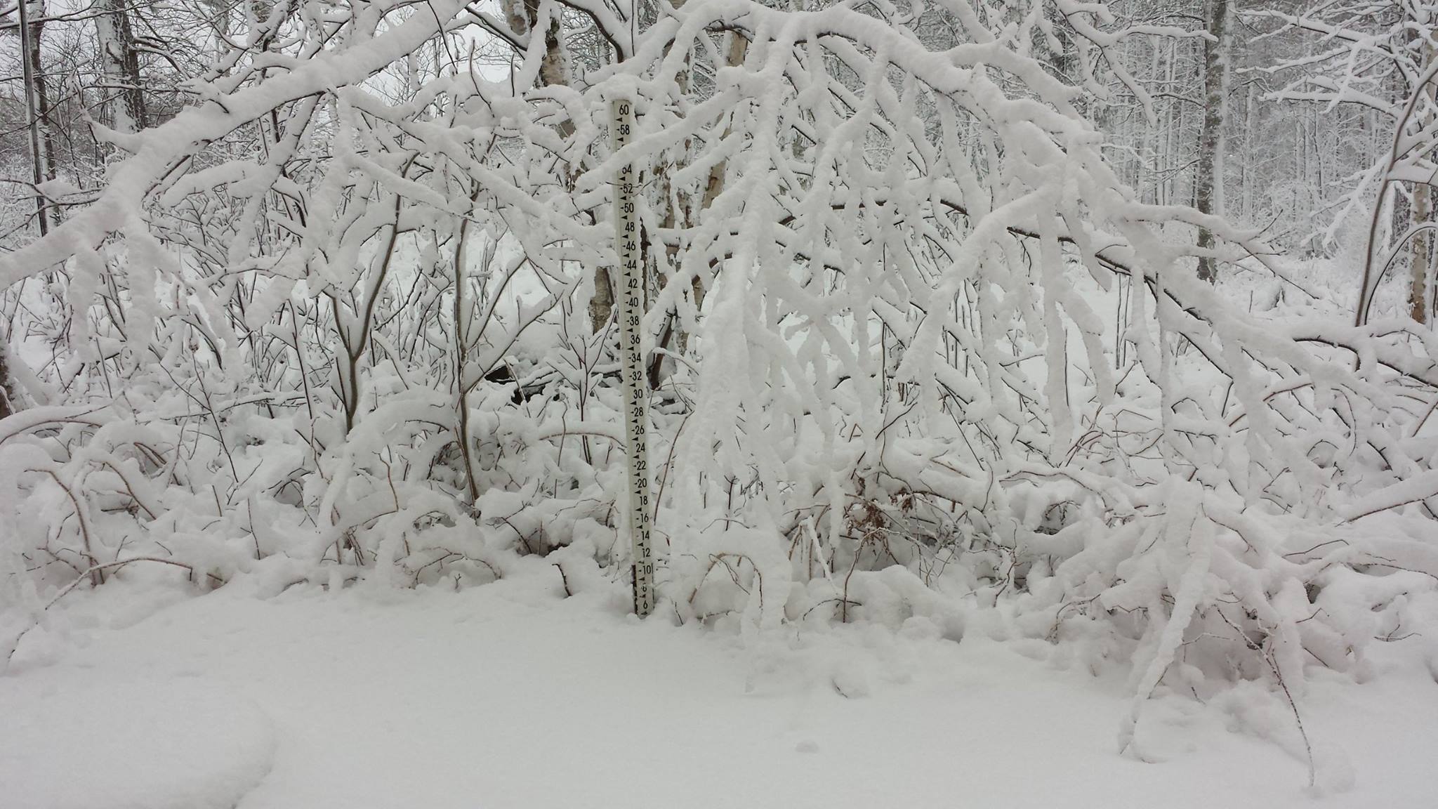
"8.9 inches of snow fell at the Duluth weather office from Tuesday night until 6 this morning. Here's a photo taken yesterday of one of our snow stakes."
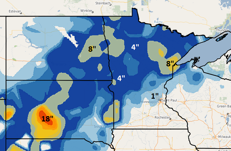
Recent Snowfall
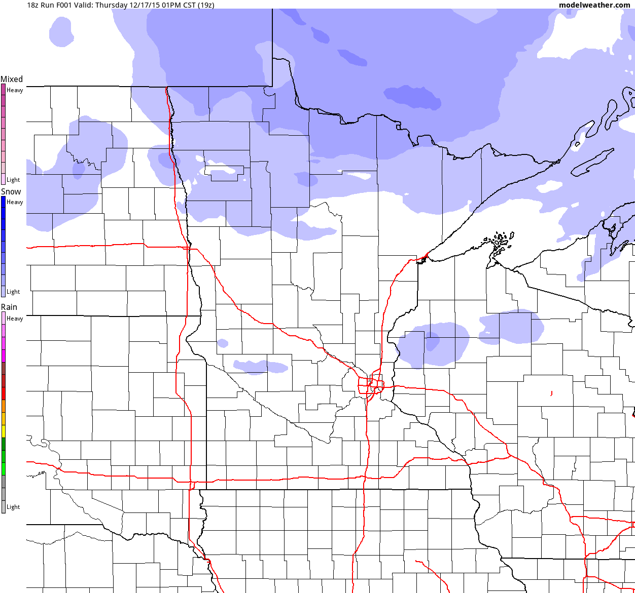
The map below suggests the latest snowfall from AM Tuesday to AM Thursday. While the MSP airport only saw 0.7", parts of the state saw nearly 4" to 8"+. Also note that parts of South Dakota got slammed earlier this week with nearly a foot and a half of snow!
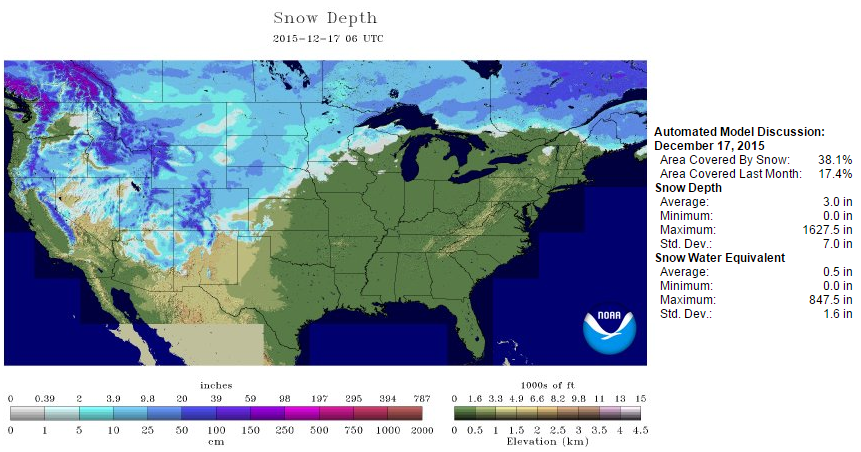
National Snow Depth
According to NOAA's NOHRSC, the national snow cover as of December 17th was around 38%. This is up significantly from last weeks near 7%
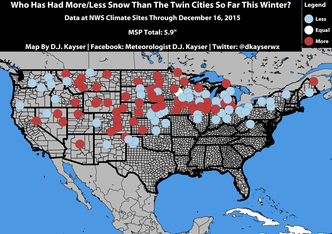
Who Has Had/More Snow Than Minneapolis So Far This Season?
Thanks to my good friend and colleague, DJ Kayser, for the graphic below, which shows who has had more or less snow than the Twin Cities so far this season. Note that all the red dots are places that have seen MORE snow, while all the blue dots indicate places that have had LESS snow that the Twin Cities. Interestingly, some places like Des Moines, Chicago and parts of Kansas have had more snow than we have!
________________________________
Crunchy Lawns - Toasty Christmas Break Brewing
By Paul Douglas
My freeze-dried, flash-frozen lawn (which needs to be mowed, by the way) is encrusted in a cellophane-thin layer of ice. So is the lake. Maybe I can mount the ice house on a rubber raft this year.
I fear I've forgotten how to shiver - but it'll come back to me. Mother nature suffered a nervous breakdown Wednesday with rain, hail, slush, thunder and lightning; an atmospheric exclamation
point heralding the arrival of an old fashioned cold front.
The sun breaks through a stubborn deck of stratus today, but it won't help much. Wind chill readings hold in single digits. A few neighbors who don't any better will complain about the cold.
Any snorts of indignation won't last long. Another surge of Pacific-flavored air arrives over the weekend with a shot at 40F by Sunday. The metro stays above freezing much of next week; highs in the 30s to near 40F. A slushy mix is possible midweek, maybe a cold rain late Christmas Day. A white Christmas in the Twin Cities this year is doubtful.
NOAA's GFS model predicts temperatures 30F above average a week from Sunday. This is getting weird.
_____________________________
Extended Forecast
THURSDAY NIGHT: Scattered flurries, breezy and cold. Winds: W 10-15. Low: 14 (Feels Like: 0F to 10F)
FRIDAY: Coldest day in sight. Partly sunny with scattered flurries. windchill near 0F to -5F at times. Winds: NW 10-15. High: 23
FRIDAY NIGHT: Partly cloudy and cold. Winds: WNW 10-15. Low: 10.
SATURDAY: Cold start, more sun peeking out. High: 28
SUNDAY: Clouds increase, thawing out again. Wake-up: 26. High: 40
MONDAY: Flurries, then trending cooler. Wake-up: 29. High: 33
TUESDAY: Mix of clouds and sun, cool breeze. Wake-up: 26. High: 34
WEDNESDAY: Marchlike, risk of a passing rain/snow shower. Wake-up: 31. High: 37
THURSDAY: Patchy clouds, up late tracking Santa. Wake-up: 29. High: 39.
________________________________
This Day in Weather History
December 18th
1923: Southern Minnesota experiences a 'heat wave'. Temperatures rose into the 60s at New Ulm and St. Peter.
1917: Milaca has its fifty-ninth consecutive day with no precipitation.
_________________________________
Average High/Low for Minneapolis
December 18th
Average High: 26F (Record: 55F set in 1923)
Average Low: 11F (Record: -24F set in 1983)
__________________________________
Sunrise/Sunset Times for Minneapolis
December 18th
Sunrise: 7:46am
Sunset: 4:33pm
*Daylight lost since yesterday: ~19 seconds
*Daylight lost since summer solstice (June 21st): ~6 hours and 40 minutes
_________________________________
Moon Phase for December 18th at Midnight
0.7 Days Since First Quarter
____________________________________
Minneapolis Temperature Trend
The average temperature in Minneapolis through the first 16 days of December were running nearly 14F above average. Readings through Saturday will be running at or below average with the coldest day likely on Friday. Note that we quickly warm to above average levels again Sunday through midweek next week. Extended forecasts bring near average temperatures in around Christmas.
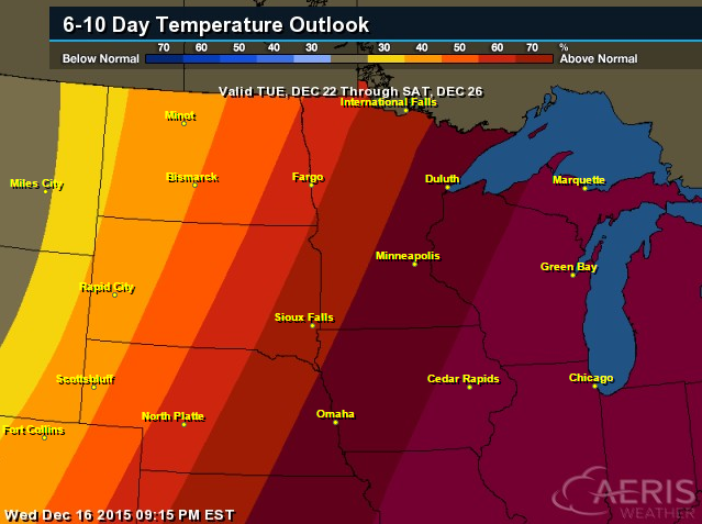
6 to 10 Day Temperature Outlook
According to NOAA's CPC, the 6 to 10 day temperature outlook suggests warmer than average readings the week leading up to Christmas.
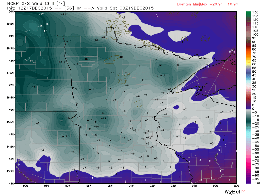
Sub-Zero Wind Chills Friday?
Here's something that we haven't had much of this season... sub-zero wind chills. Here's the GFS wind chill forecast for 6pm Friday, which suggests much of the state dealing with feels like temperatures in the -5F to -10F range then.
Friday Weather Outlook
Friday will be some of the coldest weather of the season with high temperatures dropping into the single digits and teens. With breezy winds still hanging on through the day, feels like temperatures will be likely dip into the sub-zero range across much of the state even by midday.
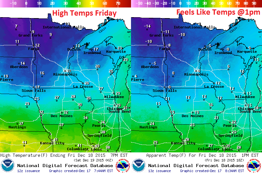
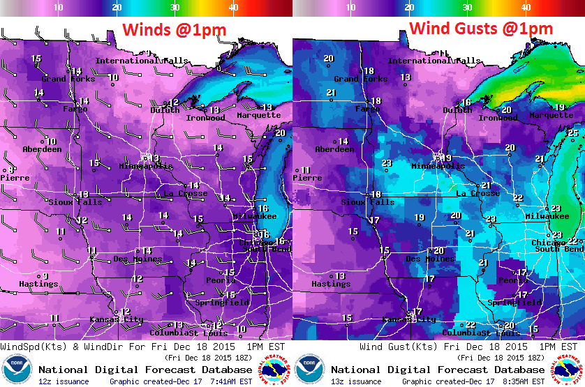
Friday Weather Outlook
Icy winds out of the WNW, at times gusting to 20mph, will help to keep chilly air in place for much of the day Friday.
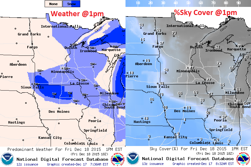
Friday Weather Outlook
There will still be a few light snow showers and flurries across the state, but no accumulations are expected.
Simulated Radar
The simulated radar through Saturday shows a few flurries and light snow showers still possible across the region on Friday with another chance of light snow moving across the northern part of the state on Saturday.
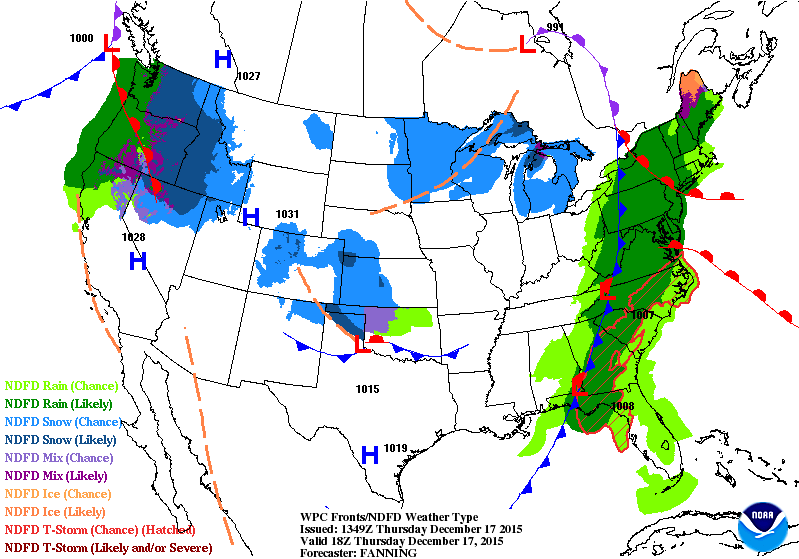
National Weather Outlook
In the wake of our recent snow event, cold air has moved in across much of the Central U.S. and will continue to work east through the early weekend. This air will be cold enough to create lake effect snow across the Great Lakes Region. Heavier rain across the East Coast will finally clear the area by late Friday/early Saturday, while more heavy Pacific moisture will move into the Pacific Northwest through the weekend! Heavy rain will be found along the coast, while heavy snow will be found in the higher elevations.
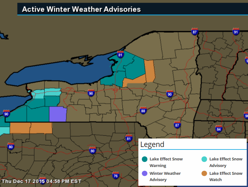
Lake Effect Snow Warning PM Friday - PM Saturday
...LAKE EFFECT SNOW WARNING REMAINS IN EFFECT FROM 4 PM FRIDAY TO
10 PM EST SATURDAY...

* LOCATIONS...CHAUTAUQUA...CATTARAUGUS...SOUTHERN ERIE...AND
  WYOMING COUNTIES. GREATEST SNOW AMOUNTS ACROSS THE BOSTON
  HILLS...WESTERN WYOMING COUNTY...AND THE CHAUTAUQUA RIDGE.

* TIMING...THE WINTER WEATHER ADVISORY IS IN EFFECT FROM EARLY
  THIS EVENING THROUGH LATE FRIDAY MORNING. THE LAKE EFFECT SNOW
  WARNING IS IN EFFECT FROM LATE FRIDAY AFTERNOON THROUGH LATE
  SATURDAY EVENING.

* HAZARDS...FREEZING DRIZZLE TONIGHT AND FRIDAY MORNING. HEAVY
  LAKE EFFECT SNOW AND BLOWING SNOW LATE FRIDAY AFTERNOON
  THROUGH SATURDAY EVENING.

* ACCUMULATIONS...A LIGHT COATING OF ICE POSSIBLE TONIGHT AND
  FRIDAY MORNING. SNOW ACCUMULATION 1 TO 2 INCHES FRIDAY...5 TO
  10 INCHES FRIDAY NIGHT...3 TO 5 INCHES SATURDAY...LEADING TO
  STORM TOTALS OF 8 TO 15 INCHES IN THE MOST PERSISTENT LAKE
  SNOWS.

* WINDS...WEST 15 TO 25 MPH WITH GUSTS UP TO 35 MPH PRODUCING
  BLOWING AND DRIFTING SNOW.
_______________________________
...LAKE EFFECT SNOW WARNING REMAINS IN EFFECT FROM 7 PM FRIDAY TO
7 AM EST SUNDAY...

* LOCATIONS...SOUTHERN JEFFERSON COUNTY...NORTHERN AND CENTRAL
  OSWEGO COUNTY...CENTRAL AND SOUTHERN LEWIS COUNTY. GREATEST
  AMOUNTS ACROSS THE TUG HILL PLATEAU.

* TIMING...FROM EARLY FRIDAY EVENING THROUGH EARLY SUNDAY
  MORNING.

* ACCUMULATIONS...5 TO 10 INCHES FRIDAY NIGHT...7 TO 13 INCHES
  SATURDAY...2 TO 4 INCHES SATURDAY NIGHT...LEADING TO STORM
  TOTALS OF 2 TO 2.5 FEET IN THE MOST PERSISTENT LAKE SNOWS ON
  THE TUG HILL PLATEAU...AND 12 TO 15 INCHES IN PERSISTENT LAKE
  SNOWS ACROSS LOWER ELEVATIONS.

* WINDS...WEST 15 TO 25 MPH WITH GUSTS UP TO 35 MPH PRODUCING
  BLOWING AND DRIFTING SNOW.
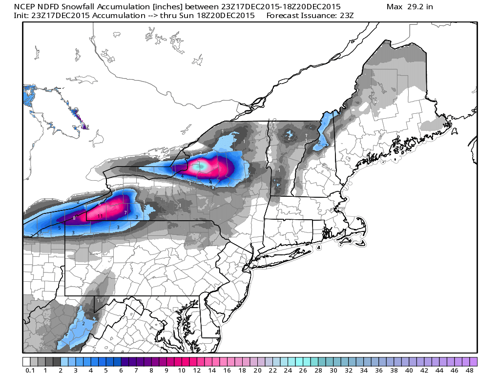
Snowfall Potential
Heavy lake effect snow bands will set up over the Great Lakes through Saturday with significant snowfall tallies possible in the Eastern Great Lakes Region. Interestingly, this could bring Buffalo, NY some of it's first measurable snow this season. Interestingly, Buffalo, NY has set a record for the latest date without seeing measurable snow.
__________________________________________
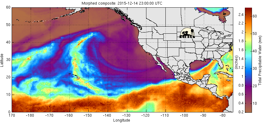
Heavy Moisture in the Pacific Northwest
Wave after wave of Pacific moisture has been hitting the West Coast over the past several days/weeks. The latest batch of heavier moisture will move through during the end of the week/weekend ahead. Interestingly, Portland, OR has seen nearly 10.50" so far this month, which is good enough for the 3rd wettest December on record!
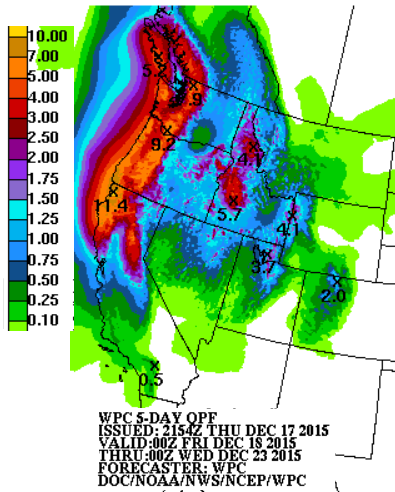
More Moisture on the Way...
According to NOAA's WPC, the 5 day precipitation forecast suggests as much as 6" to nearly 10"+, which could lead to areas of flooding. This will add to the already impressive tallies of moisture that have been adding up over the last several weeks.
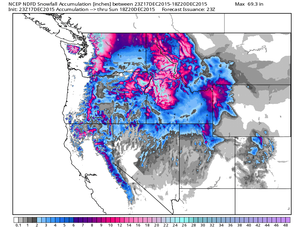
High Elevation Snow
The snowfall potential through midday Sunday looks pretty impressive across the high elevations. Some spots through the Cascades and Northern Rockies could see as much as a foot or more!
_____________________________________________
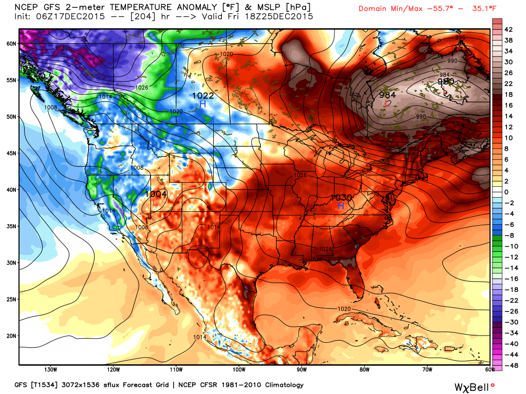
Christmas Day Temperature Anomaly
Despite
the recent cool down across parts of the country, it appears that we're
in for another surge of mild December weather next week. The image
below suggests the temperature anomaly for Christmas Day, where the
orange/red colors indicate warmer than average temperatures. Note that
much of the eastern half of the country could be dealing with much
warmer than average temperatures, perhaps even near record warmth in
some spots?
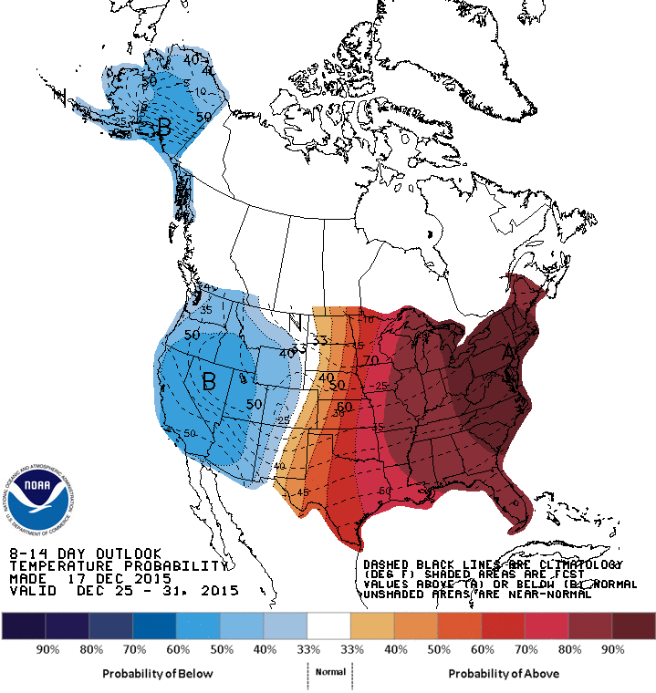
Extended Temperature Outlook
According
to NOAA's CPC, the 8 to 14 day temperature outlook suggests warmer than
average temperatures continuing in the Eastern U.S. through the end of
the month, while the western half of the country looks cooler than
average.
 ___________________________
Thanks for checking in and have a great rest of your week/weekend ahead! Don't forget to follow me on Twitter @TNelsonWX

No comments:
Post a Comment