41 F. high Wednesday at KMSP before the cold front arrived.
27 F. average high on December 16.
30 F. high on December 16, 2014.
.37" rain fell in the Twin Cities yesterday.
.7" snow fell at MSP before a changeover to rain.
2.5" snow fell at Brainerd yesterday.
December 17, 1996:
20 to 40 mph winds combined with recent snowfall produce blizzard like
conditions for about a 36 hour period over much of the area. Whiteout
conditions are common in rural and open areas. Every county road in
Yellow Medicine county was impassable by the morning of the 18th.
Travelers heading west were stranded in Clara City as plows were pulled
off the road. Wind chills were as low as 60 degrees below zero.
December 17, 1946: Heavy snow is reported along with strong wind across northern Minnesota. Duluth has winds up to 62 mph.
 Thunder & Lightning in mid-December? It's Complicated
So
this is what December is supposed to feel like. The first half of
December was nearly 14F warmer than average in the Twin Cities with 7
nighttime lows at or above 32F. Remarkable.
What's really going
on? It's over-simplistic to point to only El Nino. Yes, that's a huge
signal, but so is the additional warming of the atmosphere and oceans,
which will make 2015 the warmest year on record, worldwide by a very
wide margin.
But the Arctic Oscillation (AO) is another big
factor in our persistent warmth; a strong positive value reflecting
unusually low pressure over the Arctic region. When this happens the
dreaded polar vortex tends to stay over far northern latitudes, with
fewer intrusions of Siberian air into the USA. We've seen a positive
phase most of autumn; no signs of an imminent shift that would divert
polar air into Minnesota.
Until and unless that happens we'll see
more slop-storms with temperatures near freezing; more neutered cold
fronts. Enjoy 20s today and
Friday, but Pacific air blows more 30s into town next week; 40F possible by next
Wednesday.
Snow? Maybe a cosmetic coating
Monday morning.
Can I interest you in a beige Christmas?
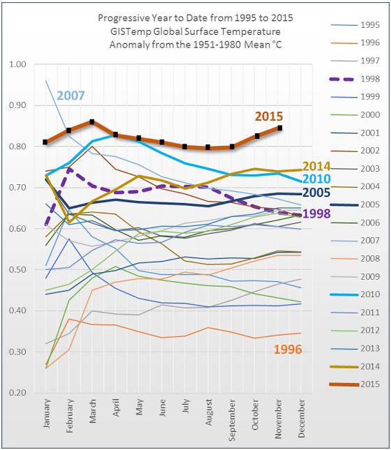
* Image credit above: NASA GISS and
Hot Whopper.
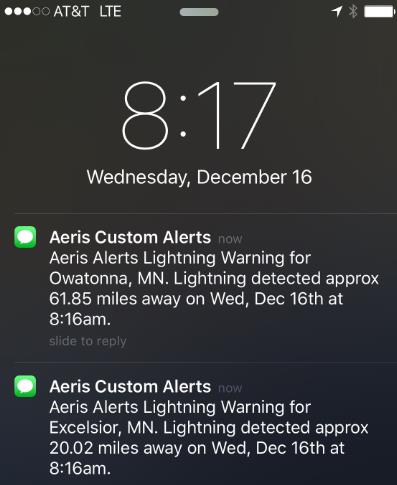
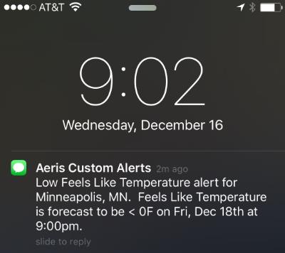
An Unlikely Alert in Mid-December.
My phone was barking yesterday, a series of texts warning of lightning
moving in. At first I thought it was bad code or a bug. Then the
lightning flashes directly overhead and cracks of thunder convinced me
otherwise. Very rare for mid-December.
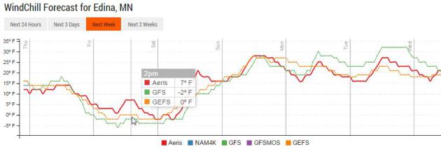
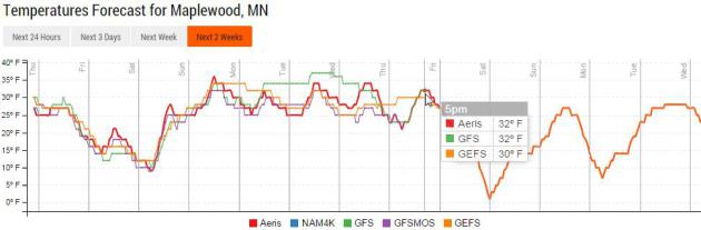
A Touch of Wind Chill.
Yes, we've gotten a little soft. I fear I've forgotten how to shiver -
but I suspect it will come back to me, just like riding a bike, right?
Models are in fairly tight alignment, meaning a high probability of wind
chills in single digits to near 0F by Friday. Source: Aeris Enterprise.
Temperatures Recover Next Week.
Models show another streak of daytime highs above 32F from Sunday into
Christmas Eve. No sustained polar air in sight yet. I think I said
something similar back in late October.
A Feeble December.
Yes, it will feel like winter out there today and Friday, but expect a
quick temperature rebound over the weekend; upper 30s to near 40F by
Sunday with temperatures as much as 10-20F warmer than average much of
next week. The early (European) prediction for Christmas Eve: 39F high
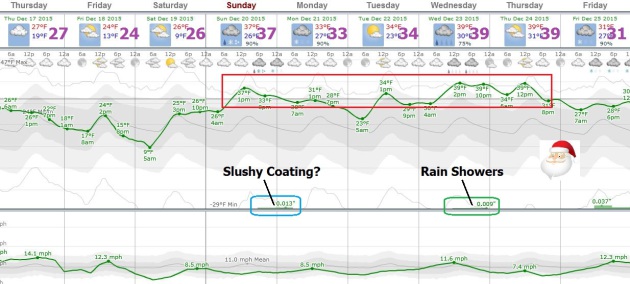
with temperatures falling into the 20s Christmas Day. A coating of slush
is possible Sunday night into Monday morning, but the atmosphere should
be warm enough for rain showers the middle of next week. A white
Christmas in the metro area? A few piles of slush here and there, but
more green than white this year.
10-Day Snowfall Potential.
Here is GFS model data, showing Wednesday's plowable snow event from
Fargo (8") to Duluth (7"), but very little accumulating snow over the
northern tier of the USA into Saturday, December 26. Source: NOAA and
AerisWeather.
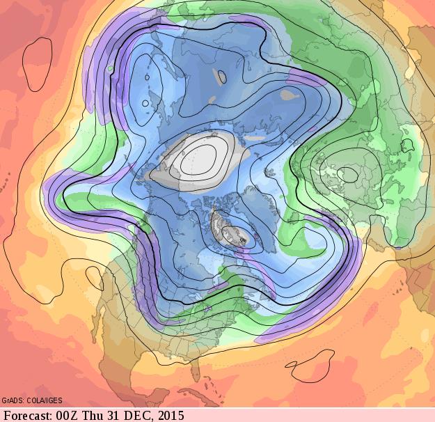
A Merry (Slushy) New Year's Eve?
The flow is still modified Pacific, waves of colder air trying to push
southward the last couple days of 2015 as a trough of low pressure
pushes across the Rockies and Plains. It may be cold enough to snow, but
it's still unclear whether any significant southern moisture will be
able to penetrate this far north. Source: GrADS:COLA/IGES.
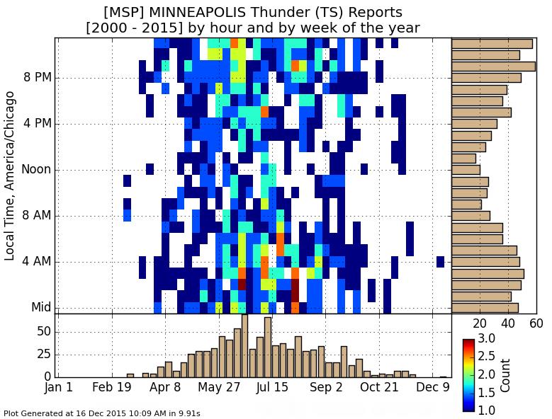 Monthly Frequency of Thunder at MSP
.
As you can see, at least since 2000, reports of thunder/lightning at
KMSP are exceedingly rare, with no reports the last 15 years from
January into mid-February. I wonder if that will change too. Graphic:
Iowa Environmental Mesonet.
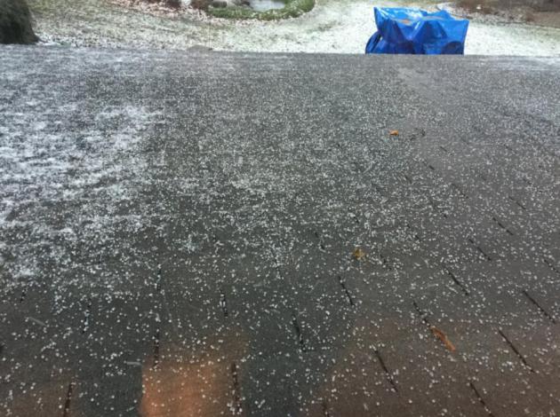
Manic Meteorology.
Wednesday, in the span of 2 hours, like so many others around the metro
area, I witnessed rain, hail (pea-size), sleet, snow and sunshine. It
was the rough equivalent of 3 seasons squeezed into 120 minutes.
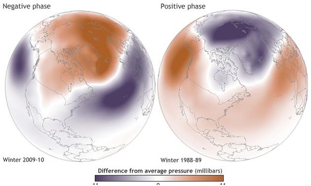
Record U.S. Temperatures are Work of El Nino and Polar Vortex, Experts Say.
It's a combination of factors, including what may still wind up being
the biggest El Nino since 1997-98. This winter the polar vortex shows no
(immediate) signs of dipping south. Here's an excerpt from
The Guardian: "...
Halpert
explained that the polar vortex, a circular swirl of cold air moving
around the north pole, varies in pressure throughout the winter season –
changes called the Arctic oscillation. High pressure expands the system
until the bands of cold wind break along the southbound jet stream,
spewing icy weather southward into the US. Low pressure holds the vortex
winds wrapped in a closer ring around the pole, trapping Arctic air in
the region..."
Image credit: "
Polar vortex
variations: high pressure (cold breaking into the US) on the left, low
pressure (cold trapped to the north) on the right." NOAA.
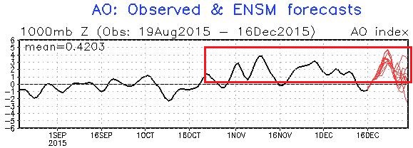
Positive Phase of AO (Arctic Oscillation).
We've witnessed a consistently positive phase of the AO since mid
October, a trend which is forecast to continue into early January,
possibly longer. Source: NOAA.
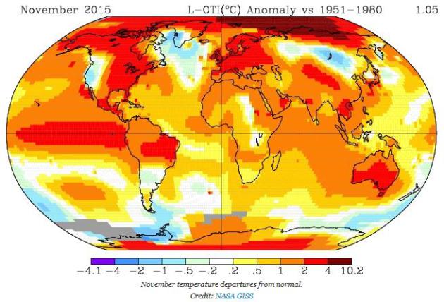
The Globe's Hottest Year Just Keeps Getting Hotter. Here's a clip from
Climate Central: "...
November
marks the second month in a row the global average temperature was more
than 1°C (1.8°F) above the 1951-1980 baseline period NASA uses. October and now November are the first time in NASA’s dataset that a given month has been a full degree Celsius above average. There’s a telltale sign of El Niño
with warmth in the tropical Pacific. But the Arctic is where the real
departures from normal were in November. Seriously, look at the map
above and the corresponding scale. Temperatures were as much as 18°F
(10°C) above normal in the Arctic and parts of Russia..."
Map credit:
NASA GISS
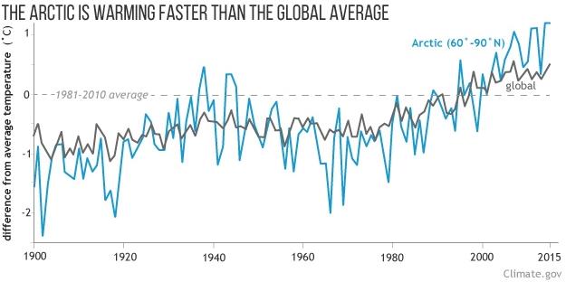
Arctic Continues to be Significantly Warmer Than Average. NOAA's Climate.gov has the details; here's an excerpt that caught my eye: "...The
graph beneath the map shows annual temperatures for the Arctic (areas
between 60° and 90° North latitude) and the globe since 1900. Arctic
temperatures (red line) are more variable from year to year than global
temperatures (bigger swings above and below average). But despite the
variability, a trend is clear: the Arctic has warmed more than the globe
as a whole. This amplification of climate change occurs for two main
reasons. First is the feedback loop that gets underway as temperatures
rise and snow and ice melt. The less snow and ice on the ground or ocean
during the Arctic’s long summer days, the more sunlight the ocean and
land absorb. The more they absorb, the warmer they get, and the more ice
and snow melt..."
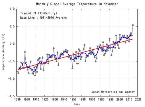
November Crushes Temperature Record While 2015 Careens Toward New Milestone. Andrew Freedman has details at
Mashable; here's an excerpt: "...
New
data in from the Japan Meteorological Agency (JMA) and NASA show that
November 2015, like many of the months preceding it this year, was by
far the warmest such month on record. In fact, in NASA's database,
November narrowly fell short — by about 0.01 degrees Celsius — of the
record set in October for the largest temperature departure from average
for any month since 1880. The warmth in 2015 is being driven primarily
by two factors — manmade, long-term global warming plus a near-record
strong El Niño in the Pacific Ocean. An analysis by the journalism and
research group Climate Central
found that manmade global warming is the bigger factor out of the two,
which is backed up by the fact that 13 of the 15 warmest years have
occurred since the year 2000, including many years that did not have El
Niño events..." (Image: JMA).
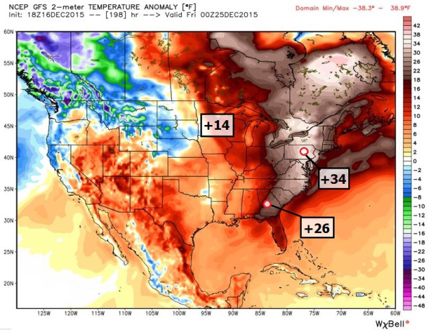
More Exceptional Warmth Shaping Up For Eastern USA During Christmas Week. Details from The
Capital Weather Gang: "...
The Eastern United States is just coming off a December “heat wave”
this week, and temperatures will slowly fall back to normal by the
weekend. But don’t get too comfortable in your winter coats — another
warm-up is expected to peak in the days around Christmas, and it, too,
has the potential to topple records...." (Temperature anomalies valid Christmas Eve: NOAA and WeatherBell).
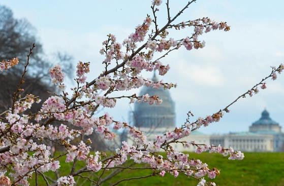
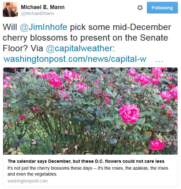
Retailers Feel the Heat of Lost Winter Clothing Sales. Not a great time to be selling boots or heavy coats. Here's a clip from
The New York Times: "...
But
despite the rise of weather planning and the use of analytics,
retailers large and small say they have been stumped by this year’s warm
start to the season, which has pushed temperatures into the high 60s
along some parts of the East Coast. In some places, fading rose blooms
and drooping flowers still cling to plants along some city streets.
Understandably, shoppers are not in the mood for winter coats or boots.
Macy’s has already warned that it will need to offer big discounts to
sell the winter inventory that is piling up in its stores after a slow
third quarter. Nordstrom similarly blamed warm weather for its
underwhelming fall performance..."
Photo credit above: "
Cherry blossoms are seen on the street in Washington DC on Tuesday due to the warm weather." Photograph: Bao Dandan/Xinhua Press/Corbis.
70-Degree Days in December. What?
How much of the record warmth is natural, how much is driven by El Nino
and the larger warming trend observed worldwide? Here's an excerpt from
The Atlantic: "...
Alexis
Madrigal, an Atlantic contributing editor, coined a term for such
weather: “climate changey.” Scientists repeat that few individual
weather events can be linked to climate change, and yet, how can an
iced-coffee Advent be normal? Surveying an unprecedented California
heatwave, historic flooding in South Carolina, and a strange and
perplexing sandstorm in Tel Aviv, he wrote in October:
“We need a word that reflects the basic anxiety of not knowing what the
weather means anymore.” Climate changey is that phrase. In Madrigal’s
telling, climate changey stands in for both the weather event and the
mental state. In the 2010s, even when weird weather is enjoyable, it
feels like a planetary memento mori. Say goodbye to that white Christmas—more of this is coming, and also, by the way, you may die in it...
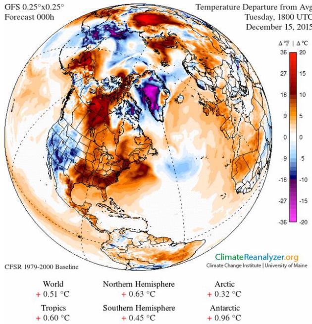
Temperature Anomaly Map:
Climate Reanalyzer.
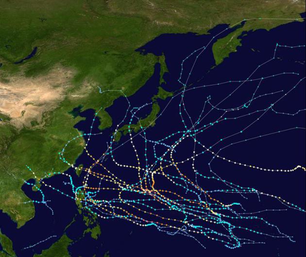
Pacific Hurricane, Typhoon Records Keep Falling With Weeks to Go. Supernaturally quiet in the Atlantic, but the Pacific basin has been a different story - here's an excerpt from
Bloomberg Business: "...
The
Accumulated Cyclone Energy index, which meteorologists use to plot the
intensity of a tropical season, set a record in the Pacific this year,
said Phil Klotzbach, lead author of Colorado State University’s Atlantic
seasonal hurricane forecast. The index across the Pacific was 765
through Tuesday, breaking the old mark of 760 set in 1992, he said. In
addition, the Northwestern Pacific has had 16 major storms, reaching
Category 3 or higher on the Saffir-Simpson scale, which is also a
record, Klotzbach said. The previous mark was 15 in 1958 and 1965. On
top of that, the Northern Hemisphere saw 26 Category 4 or 5 systems, the
strongest on the scale, breaking the record of 18 set in 1997 and 2004,
he said..."
Map source:
Wikipedia.
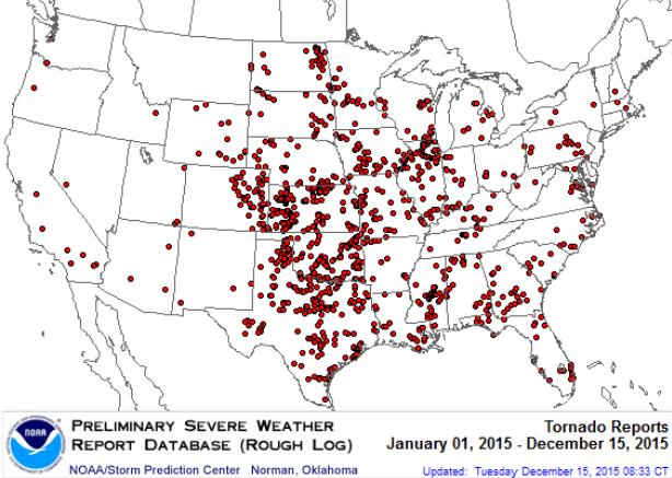
2015: Fewest U.S. Tornado Deaths on Record? CBS 58 in Milwaukee has the story - here's a link and story excerpt: "
It's
been an exceptionally quiet year for tornadoes. In fact, there have
been only 10 tornado fatalities in 2015. If this number doesn't change,
it would beat the twelve deaths reported in 1910. Two sources of
statistics were combined to create the long period of record. The
National Weather Service's Storm Prediction Center keeps a file on
tornado deaths since 1950. Also, one tornado historian added to this
study with his database going back to 1875. On average, the U.S. sees 36
EF-3 or stronger tornadoes. This year there have been just 16. The
violent tornadoes, EF-4 or stronger, usually add up to seven per year.
However, this year, only one happened, just west of Chicago in early
April..."
Map source:
NOAA SPC.
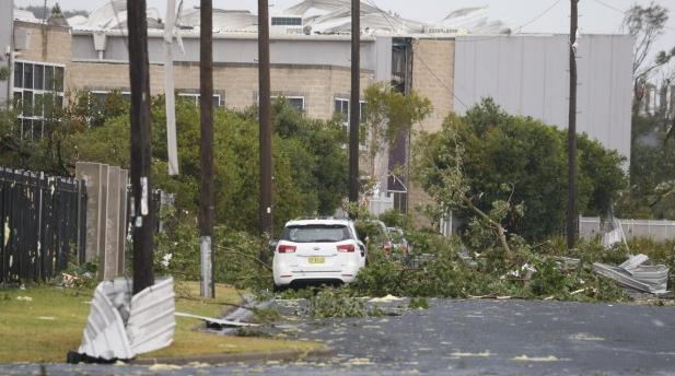
Rare Tornadoes and "Cricket-Size Hail" Hits Sydney, Australia. Think about it - baseball size hail just doesn't compute Down Under. Here's an excerpt from
Yahoo News: "
A
rare tornado hit Sydney on Wednesday with destructive winds above 200
km an hour (125 mph) and cricket ball-sized hail, bringing down trees
and power lines, sheering off roofs and walls and causing flash flooding
in Australia's largest city. The Bureau of Meteorology (BOM) issued the
rare tornado warning around midday as the dangerous storm swept up the
coast from Sydney's south, forcing some international and domestic
flights to be diverted to other cities..." (Image credit: Peter Rae,
Sydney Morning Herald).
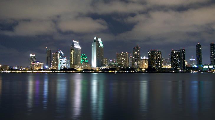
San Diego Vows To Move Entirely To Renewable Energy in 20 Years. Here's the intro to a New York Times story: "Last weekend, representatives of 195 countries reached a landmark accord
in Paris to lower planet-warming greenhouse gas emissions. On Tuesday,
local leaders in San Diego committed to making a city-size dent in the
problem.With a unanimous City Council vote, San Diego, the country’s
eighth-largest city, became the largest American municipality to
transition to using 100 percent renewable energy, including wind and solar power. In the wake of the Paris accord, environmental groups hailed the move as both substantive and symbolic..." (File image: Wikimedia Commons).
Weirdest Gadgets of 2015.
Engadget has a marvelously odd list; here's an excerpt: "...
What do you get the drunk bicyclist who has everything? Barring some self-control, how about the Alcoho-Lock Bike Lock?"
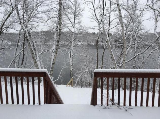
Breaking News: It Snowed Up North!
My friend, Pete Schenck, snapped this photo up at his place on
Ossawinnamakee Lake yesterday - looks like about 3" - just enough to
cover up his green lawn.
TODAY: Mostly cloudy, brisk! Wind chills in the teens. Winds: W 10-20. High: 27
THURSDAY NIGHT: Patchy clouds, plenty cold. Low: 12
FRIDAY: Coldest day in sight. Partly sunny, windchill near 0F at times. Winds: NW 10-15. High: 19
SATURDAY: Patchy clouds, not as harsh. Wake-up: 9. High: 29
SUNDAY: Intervals of sun, thawing out again. Wake-up: 26. High: 36
MONDAY: Light snow tapers to flurries. Coating possible. Wake-up: 29. High: 32
TUESDAY: More clouds than sun, fairly mild. Wake-up: 26. High: 36
WEDNESDAY: Marchlike, risk of a passing rain shower. Wake-up: 28. High: near 40
*
I snapped the photo above in Denver on Tuesday, after nearly 10" of
snow and near-blizzard conditions struck the Mile High City. Yes, I
wanted to see snow that bad.
Climate Stories...
Paris Climate Accord is a Big, Big Deal. The pride of St. Louis Park, Thomas Friedman, thinks so. Here's the intro to a recent Op-Ed at
The New York Times: "
I
had low expectations for the U.N. climate meeting here and it met all
of them — beautifully. I say that without cynicism. Any global
conference that includes so many countries can’t be expected to agree on
much more than the lowest common denominator. But the fact that the
lowest common denominator is now so high — a willingness by 188
countries to offer plans to steadily and verifiably reduce their carbon
emissions — means we still have a chance to meet what scientists say is
our key challenge: to avoid the worst impacts of global warming that we
cannot possibly manage and to manage those impacts that we can no longer
avoid. That is a big, big deal..."
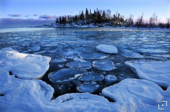
Superior Is One of the More Rapidly Warming Lakes, Study Finds. Jennifer Brooks has the story at
The Star Tribune; here's the intro: "
The
world’s lakes are warming up — even frigid Lake Superior — scientists
warn. Dozens of researchers pooled decades’ worth of data from hundreds
of lakes and concluded that the world’s lakes are warming even more
rapidly than the oceans or the atmosphere. The warmer waters threaten
fish populations, ecosystems and fresh water supplies around the globe..."
File photo above: Brian Peterson, Star Tribune. "
As
Lake Superior struggled to freeze over, pancake ice developed in the
bay near Cove Point. Researchers say Lake Superior is warming even
faster than the global average."
 Will Global Warming Heat Us Beyond our Physical Limits? National Geographic
 asks the question, based on new research; here's the intro: "
If
greenhouse gas emissions are not reduced, rising temperatures and
humidity wrought by global warming could expose hundreds of millions of
people worldwide to potentially lethal heat stress by 2060, a new report
suggests. The greatest exposure will occur in populous, tropical
regions such as India, Southeast Asia, the Middle East, and Africa. But
even in the northeastern United States, as many as 30 million people
might be exposed at least once a year to heat that could be lethal to
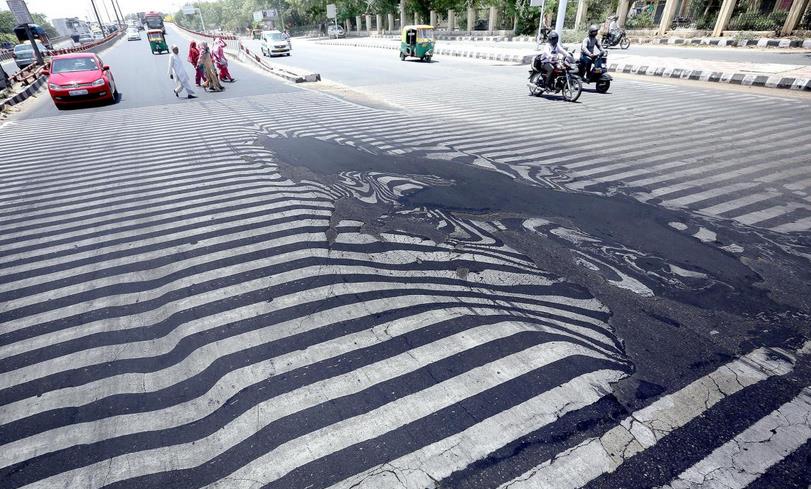
children, the elderly, and the sick, according to the new study..."
Photo credit above: "
In India last May, temperatures rose to 120°F (50°C), killing more than 2,300 people—and melting this street in New Delhi". Photo: Harish Tyagi, EPA.


No comments:
Post a Comment