Meteorologist Paul Douglas writes about Minnesota weather daily, trying to go beyond the "highs" and "lows" of the weather story to discuss current trends and some of the how's and why's of meteorology. Rarely is our weather dull - every day is a new forecast challenge. Why is the weather doing what it's doing? Is climate change a real concern, and if so, how will my family be affected? Climate is flavoring all weather now, and I'll include links to timely stories that resonate with me.
Saturday, January 2, 2016
Hints of a Real Cold Front: Subzero Streak 7-10 Days Away
31 F. high in the Twin Cities Saturday. 24 F. average high on January 2. 28 F. high on January 2, 2015.
4" snow on the ground at KMSP.
January 3, 1981: Arctic air visits Minnesota. Embarrass, Wannaska, and Tower all hit 38 below zero. January 3, 1977: 14.2 inches of snow falls in Mankato.
Parka Alert: Subzero Possibilities Next Week
"Pale
January lay in its cradle day by day, dead or living, hard to say"
wrote Alfred Austin in Primroses. January is the reason Minnesota
doesn't have a population of 20 million, which is probably a good thing.
Long shadows, numbing nights, a wind chill capable of making a grown man cry; January is an acquired taste.
On
the other hand road construction is in suspended animation, the
mosquito count is down, and the weeds in my yard are hibernating.
Historical
data shows the coldest weather of the entire year is 1-2 weeks away, on
average. That won't be hard to believe next week, possibly the coldest
of 2016.
The sun stays out much of today and Monday as temperatures cool down to average; expect a late-week thaw with a chance of some wet snow by Friday & Saturday. Nuisance amounts are possible - this doesn't look like The Big One.
A
hunk of polar air breaks off and pinwheels across the Midwest next
week. Daytime highs may hold in single digits with 2-4 nights below
zero.
Unlike previous winters I don't see a prolonged push of polar pain, just a few days of nicely numb.
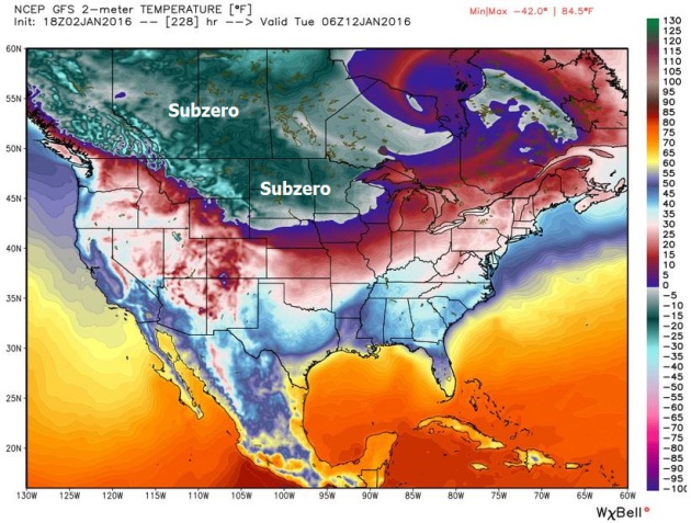
A Real Cold Front.
Here is the 2-meter temperature forecast for 1 AM Tuesday morning,
January 12, showing temperatures well below zero across Minnesota and
the Dakotas, a wind chill as low as -20F. It will be the first real
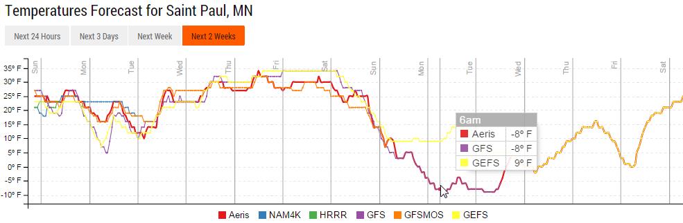
arctic slap of the winter season. Map: WeatherBell. Plenty of Ice for the St. Paul Winter Carnival.
I can't rule out a thaw by the third week of January, but temperatures
should be sufficiently cold in 7-12 days for thicker ice to form on area
lakes. The predicted temperature at 6 AM, January 11 in St. Paul is a
nippy -8F. Something to look forward to. Source: Aeris Enterprise.
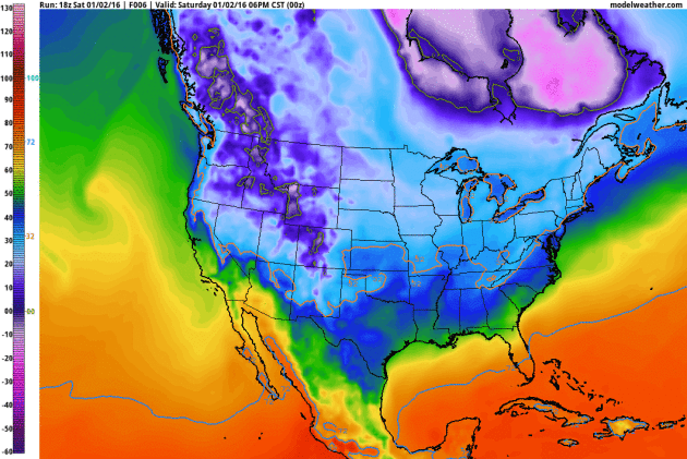
A Pinwheel of Pain.
Temperatures trend above average for the next 7 days, but you can watch
the leading edge of subzero air (bright purple) pushing southward out
of Canada by next weekend, setting the stage for a few polar days in
Minnesota. Source: NOAA (GFS) and AerisWeather.
Change in the Weather?
The Arctic Oscillation has been positive much of autumn 2015, meaning a
tight polar vortex with few southern intrusions of bitter air, but NOAA
models suggest a shift to a negative phase is underway, which means a
good chance of a few (polar) outbreaks within 1-2 weeks. That said, the
volume, intensity and duration of polar air this winter probably won't
be as severe as recent winters as a warm El Nino signal continues to
overwhelm the pattern across North America.
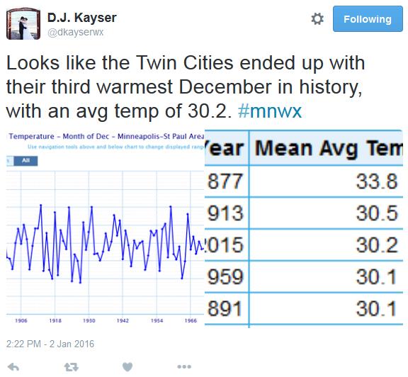
Warmest December Statewide, Third Warmest December for MSP. Thanks to AerisWeather meteorologist D.J. Kayser for passing along this weather nugget.
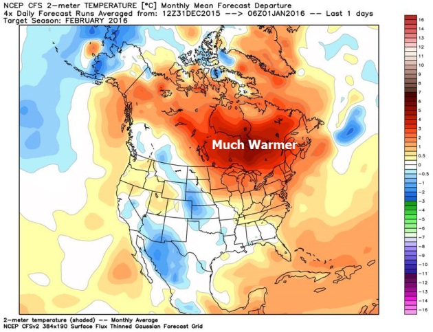
Mild Signal Lingers Into February?
Here is NOAA's CFS climate model guidance for the month of February,
showing temperatures 3-5F warmer than average across Minnesota next
month, even warmer across much of Canada. Source: WeatherBell.
AerisWeather Briefing: Issued Saturday evening, January 2, 2016.
*
The much advertised El Nino pattern, the strongest since 1998, will
shift the storm track southward, putting California in its cross-hairs
next week with a series of wet, Pacific storms sweeping inland.
* Waves of heavy rain arrive Sunday night and Monday, with additional heavy rain Tuesday, Wednesday and Thursday.
*
Northern California and the Bay Area will experience the heaviest rains
(3-5" amounts) by the end of next week, but the Los Angeles
metropolitan area will pick up some 1-3" amounts, capable of significant urban flooding and minor power outages.
*
Winds gust to 50 mph with a heightened risk of mudslides as squalls of
very heavy rain push inland. Expect snow above 4,500 feet.
* Facilities
that normally experience flooding or power disruptions during heavy
winter rainfall events will probably see problems next week, possibly as
early as Monday.
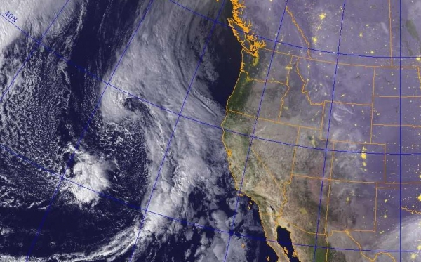
Parade of Storms.
The late afternoon satellite image shows at least 3 separate storms
lined up off the west coast. For much of the winter the firehose of
moisture spawned by El Nino has been focused on the Pacific Northwest,
with record flooding in the Portland, Oregon area. Now the pattern is
shifting as colder air pushes the main highway for storms 500 miles
farther south, meaning a much better chance for flooding rains across
California in the coming weeks.
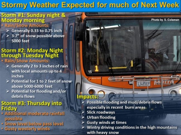
On Alert.
The graphic above is from the Los Angeles office of the National
Weather Service, describing the impacts of at least 3 separate storm
systems between now and Friday. For the first time this winter the Los Angeles area will see significant weather-related disruptions next week.
NOAA in Los Angeles warns:
"A
series of storm systems are expected to impact southwestern California
Sunday night through Friday. The first storm is expected to move across
the area Sunday night into Monday, bringing generally light rainfall
with snow level around 5000 to 6000 feet. From Tuesday through Friday,
additional storms are expected with periods of rain, mountain snow and
gusty winds. There is the potential for significant rainfall of 2 to 4
inches for many areas with local accumulations up to 6 inches for
south-facing slopes. Significant snowfall is also possible above 4500 to
5000 feet, with winter storm conditions due to heavy snow and gusty
winds. The exact timing and intensity of each weather system is still in
question, but the overall weather pattern appears to be a wet one for
the coming week. In addition, communities in and around recent burn
areas, especially the Colby, Madison, Powerhouse, Madre, Solimar and
Springs burn areas, will need to be alert for the potential for heavy
rainfall at times which could produce flash flooding with mud and debris
flows. Drainage areas should be cleared of debris to help reduce the
chance of urban flooding."
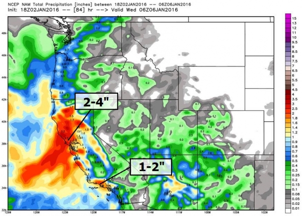
Predicted Rainfall by Midnight Tuesday.
As much as 2-4" of rain may drench the Bay Area (heaviest amounts near
the coastal range), but metro L.A. may pick up some 1-2" amounts Monday
and Tuesday, resulting in significant hydroplaning on freeways, road
closures (Pacific Coast Highway is most vulnerable) and mudslides. With
winds gusting as high as 40-50 mph with some of these squalls sporadic
power outages can't be ruled out. Map credit: WeatherBell. Southern California Soaking.
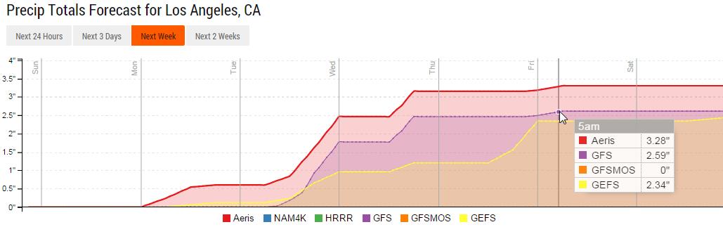
Models print out anywhere from 2.3 to 3.3" of rain for Los Angeles by
Friday of next week, thus the concern about flooding. Source: Aeris
Enterprise.
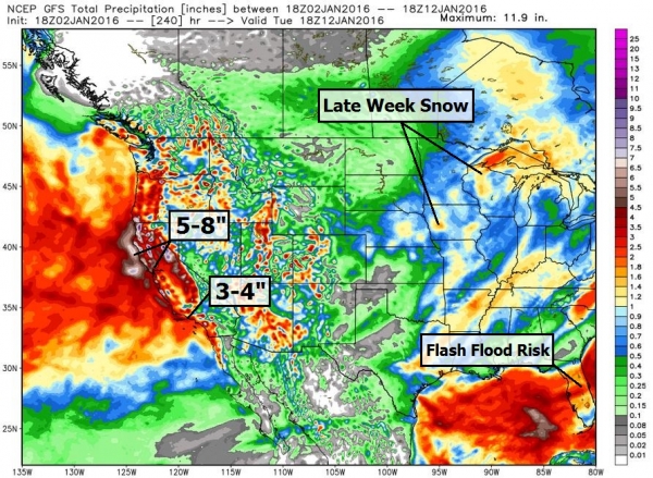
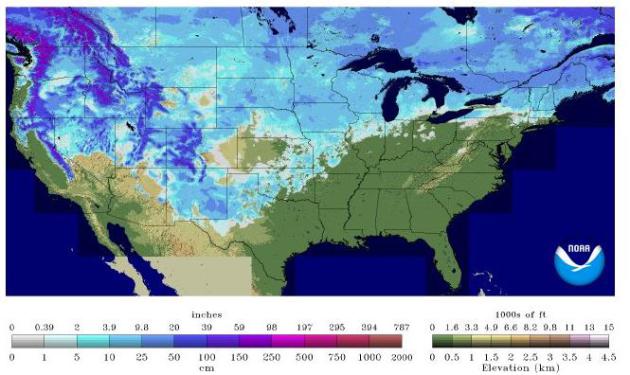
10-Day Rainfall Potential.
This will be a longer-duration flood risk; NOAA's GFS model printing
out some 5-8" precipitation amounts for northern California and 3-4"
amounts for SoCal. Heavy winter snows are likely above 4,000 feet. A
stalled frontal zone may produce 2-4" rains for Florida where flash
flooding is possible - a late week storm may drop a few inches of snow
across the Upper Midwest and Great Lakes.
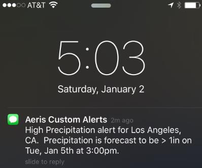
AerisWeather Custom Alerts.
I received the text alert (above) on my smartphone late this afternoon
from Aeris Enterprise Mobile; our internal models printing out 1" of
rain in Los Angeles by 3 PM Tuesday afternoon, enough to spark
significant flooding and travel disruptions.
Summary:
From killer tornadoes in December in the Dallas area to some of the
worst flooding on the Mississippi River since 1993, El Nino is already
spiking winter weather from coast to coast. It's been relatively quiet
across most of California, to date, but that's about to change. A series
of storms push inland next week and I expect significant flooding and
disruptions to transportation and infrastructure. The next 2-4 weeks may
bring some of the most disruptive and dangerous weather to California
as El Nino peaks. We'll keep you posted.
Paul Douglas, Senior Meteorologist. AerisWeather
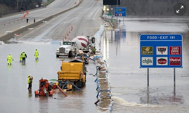
It's Going To Get Ugly: Midwest Calls in National Guard as Flood Disaster Unfolds. Here's a clip from The Guardian: "Floods have submerged towns, roads, casinos and shopping malls around the south and midwest for more than three days,
prompting governors in Illinois and Iowa to call in the National
Guard.Sixteen states issued flood warnings covering some eight million
people. By Saturday floodwaters had begun to subside in many areas,
reopening several important highways, after topping levees in the region
late on Friday. But swollen rivers have yet to crest in southern
states, alarming governors in Tennessee, Louisiana and Mississippi. At
Dardanelle, Arkansas, the National Weather Service recorded the Arkansas river at 41ft, nine feet above flood stage..."
Photo credit above: "Workers from the Missouri department of transportation attempt to pump water off I-55 near Arnold, Missouri on Thursday." Photograph: Sid Hastings/EPA.
Blizzard Kills Thousands of Cows and Threatens Texas Dairy Business.
The same storm that spawned killer tornadoes near Dallas whipped highs
winds, bitter temperatures and 5-10 foot drifts over western Texas.
Here's an excerpt from CNN Money: "The Texas dairy business took a big hit from Goliath -- the deadly storm system
that wreaked havoc in several states near the end of 2015. The storm
resulted in the loss of "hundreds of loads of milk" that were ready to
be processed and many milk-producing cows weren't milked daily,
according to Darren Turley, executive director of the Texas Association of Dairymen...."
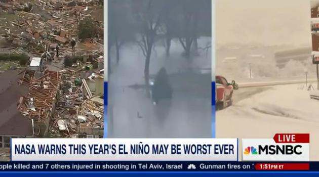
NASA Warns El Nino May Cause "Weather Chaos".
The best way I've heard it described is like going up a flight of steps
(climate change and warming, worldwide) and then standing on your
tip-toes (El Nino). A much warmer Pacific ocean may be turbocharging the
El Nino we're experiencing right now, forecast to linger into at least
spring of 2016. MSNBC has the video and story; here's an excerpt: "Despite
the devastating storms across the country the last few weeks, NASA is
forecasting the worst is yet to come. Michael Mann, author of "Dire
Predictions: Understanding Climate Change" joins to discuss."
Why We'll Keep Having Weird Weather in 2016.
Additional warmth is loading the dice, spiking the punch in favor of
more extreme events. They would have happened anyway, but a warmer
climate is "juicing" the atmosphere, making droughts and floods deeper,
longer and stronger. Here's an excerpt from TIME: "...In
recent years, a weak Arctic Oscillation has allowed cold air to escape
the Arctic, leading to a chilly winter in the Northeast U.S. But the
Oscillation appears to be holding strong, according to NOAA data,
lessening the chance of a chilly winter. Climate phenomena like El Niño
are not new occurrences, but scientists say that global warming has
contributed to making them larger and more damaging. NOAA’s Deke Ardnt
likens climate change to a flight of stairs. “Over time you get higher
and higher,” Ardnt told The Guardian.
“El Niño is like standing on your tippy toes when you’re on one of
those stairs. Both of those together work to create the warmest
temperature on record...”
Total Precipitable Water animation above courtesy of NOAA NESDIS.
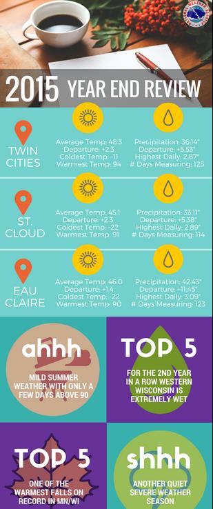
2015 Recap.
According to NOAA data 2015 was 2.3F warmer than average and about 5.5"
of precipitation wetter than normal in the Twin Cities and the St.
Cloud area. Place your bets for 2016.
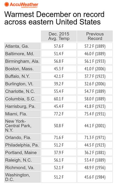
Record Warmth in December. It was the warmest December ever recorded for Washington D.C., Philadelphia, New York City and Boston, according to AccuWeather.
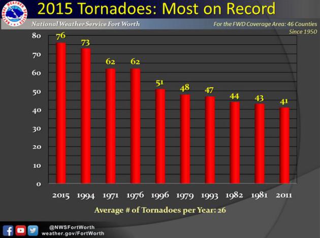
2015: Most Tornadoes on Record for Fort Worth Texas NWS Forecast Area.
The 46 counties in northern and central Texas that make up the
Dallas/Fort Worth forecast area saw 76 tornadoes in 2015, breaking the
previous record of 73 twisters in 1994.
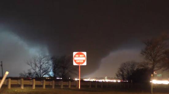
Pick of the Week: Massive Tornadoes Roar Across Texas. Typical for April, a bit unusual for late December, according to The Capital Weather Gang: "... The
storms left 11 people dead, and incredible destruction in their wake.
It was the second day of destructive tornadoes in less than a week,
following an outbreak on Dec. 23 that killed 10 people. Just like that,
in the span of four days, 2015 went from having a record low number of
tornado fatalities to tripling the annual count. In fact, between the
two tornado events, the month brought more tornado deaths than all the
other months of the year combined, making it the deadliest December on
record..."
Image credit above: "Lightning illuminates a violent tornado as it roars across the landscape between Garland and Rowlett, Texas, on Dec. 26." (Nathan Moore/Stormviewlive).
Catching a Break. Science Friday
has the story of how a self-taught meteorologist turned a call-in surf
forecasting company into a global enterprise; here's a clip: "...With
only a couple meteorology courses at Long Beach Community College under
his belt but extensive time spent studying the subject on his own, in
1985 Collins was recruited to join Surfline,
the nation’s first commercial surf prediction center geared toward
surfers. He grew the company into a global enterprise that provides
weather and forecasting services not just to surfers, but to all
lifeguard agencies in California, as well as the Coast Guard, U.S. Navy
SEALs, the National Weather Service, and television and movie production
companies, among other entities, according to a profile on Surfline.com about Collins, who passed away in 2011 at the age of 59..."
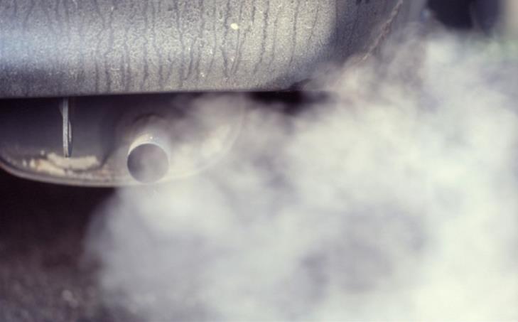
The Dirty Truth about "Clean Diesel". If it sounds too good to be true, chances are it is. Here's an excerpt from an Op-Ed at The New York Times: "...This
diesel pollution is not just unpleasant; it is also dangerous. The
nitrogen oxides produced by diesel engines, which are far more popular
in Europe than in the United States, are a potent irritant for asthma
sufferers. Health officials in Italy also noted increased reports of
cardiovascular disease this week. Diesel exhaust is laden with insidious
soot particles, the so-called PM 2.5 (particulate matter smaller than
2.5 microns, or one-thirtieth the width of a human hair), which allow
carcinogens to penetrate deep into tissues and organs. In other words, a
driver who steps on the accelerator of a diesel car may be filling the
lungs of nearby pedestrians, cyclists, infants in strollers and other
drivers with potentially deadly particulate matter..." (File image: The Telegraph).
The Brief: America Way Beyond 2016.
Predicting the future is not for the faint-of-heart. Trust me. Futurist
Eric Garland peers over the horizon in an interview at Politico; here's an excerpt that caught my eye:
DS: What is Washington getting wrong about the future? EG:
I think we were too slow to jump onto alternative energy, and, you
know, we're a car-based culture. The overall macro trend for energy has
been a transition to the grid, and it sounds weird because gas is $1.50
to $1.70 right now, and so we can all drive where we want for Christmas,
just like the good old days. I, myself, am thinking about getting my
1968 Buick Skylark Custom from high school. It got 4 gallons to the
mile. That's doable again now. But, if you look in terms of the
macroeconomics around the world, look at the infrastructure investments
that other countries are making. They're in [the] electrical grid..."
At CDC, a Debate Behind Recommendations on Cell Phone Risk. Here's an excerpt from a story at The New York Times: "...Mainstream scientific consensus holds that there is little to no evidence that cellphone signals raise the risk of brain cancer
or other health problems; rather, behaviors like texting while driving
are seen as the real health concerns. Nevertheless, more than 500 pages
of internal records obtained by The New York Times, along with
interviews with former agency officials, reveal a debate and some
disagreement among scientists and health agencies about what guidance to
give as the use of mobile devices skyrockets..." (File photo credit: Brian Peterson, Star Tribune).
What Will The Future of TV Networks Look Like? The empowered television viewer and on-demand changes everything, or does it? Here's a clip from an article at Slate: "... If
upscale audiences ditch linear for subscription on demand, advertisers
may decide TV is no longer a viable way to reach them, leaving network
TV (or even some cable networks) to go for the Walmart demo. Given how
many Americans shop at Walmart, that’s not some small niche. But it
could result in network TV looking a lot different than it does today." (Image credit: Wikipedia).
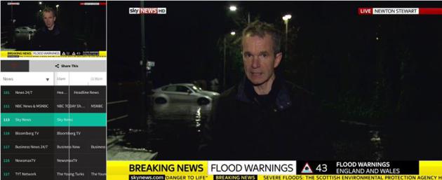
Pluto TV.
Here's another indicator of how fast the television business is
iterating, experimenting and reinventing new ways to aggregate content
(and make it more convenient to watch anytime, anywhere, on any device).
Pluto TV reminds me of the promise of Aereo - no local broadcast
stations, but you can watch NBC (reruns) and MSNBC, Sky News (pictured
above from my iPad), Bloomberg TV, CNET, reruns of Jimmey Kimmel and
Conan, food channels, sports highlights (no ESPN, sorry), even music
channels similar to what you'd see in a cable or satellite bundle. There
are apps for smart phones and tablets, or you can just click over to pluto.tv to watch on your PC or Mac. Pretty cool, and an omen of what's to come.
Getting Coffee With The President.
What do you get when you mix at '63 Stingray Corvette with black
coffee, Jerry Seinfeld and the President of the United States? One of
the funniest 19 minutes of your life. The latest installment of
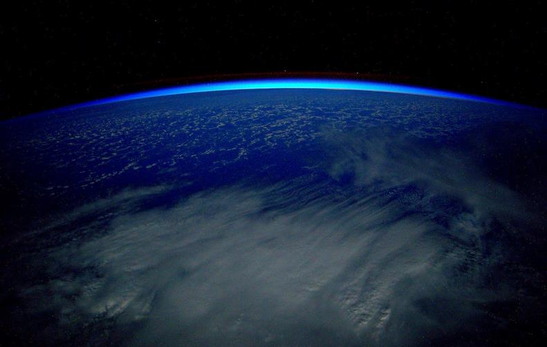
Seinfeld's "Comediens in Cars Getting Coffee" is brilliant. From 250 Miles Straight Up. NASA astronaut Scott Kelly tweeted this photo from the International Space Station on Friday. Nice.
TODAY: Sunny, a bit cooler. Winds: NW 8-13. High: 28
FRIDAY: Period of light snow, slippery. Winds: NW 8-13. Wake-up: 30. High: 33
SATURDAY: Light snow and flurries, then colder. Winds: NW 10-15. Wake-up: 27. High: 30 (falling)
Climate Stories...
MSU Study: Climate Change Denial Messaging Works. Michigan Public Radio has the story and study results; here's the intro: "Attacking the science behind climate change effectively sways public opinion, according to a recent study by
Michigan State University researchers. MSU associate professor and
sociologist Aaron McCright led the study of 1600 US adults. McCright
says messages that frame climate change as a public health or national
security threat, or even through a “positive” frame like economic
opportunity or religious obligation, seem to fall flat..." Climate Change is Showing up in Blockbusters and Binge Watches. So What? Grist has the article; here's the intro: "At
one point midway through the first episode, the camera pans past the
skyline of New York. It’s both familiar and uncanny: There’s One World
Trade Center, standing in a thicket of shinier, spindlier towers that
announce we are now in The Future. And standing sentinel outside the
city is the Statue of Liberty — except now she is ringed by a reinforced
seawall, set in ten feet of angry surf. That’s it. That’s all the
reference to climate change we get in the 45 minute-long pilot of The
Expanse, SyFy’s new space drama. In fact, only a handful of those
minutes are spent on Earth at all..."
“...What
is most unfortunate,” said Farrell, the Yale sociologist, “is that
polarization around climate change was manufactured by those whose
financial and political interests were most threatened.” Even today, he
added, that polarization has crippled any hopes for bipartisan policy
solutions.... "
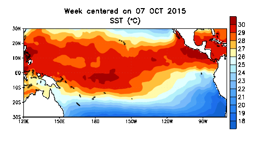
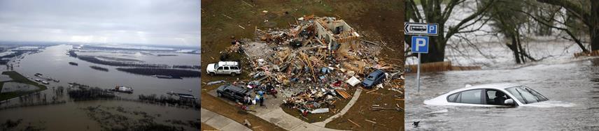
Climate Chaos, Across the Map. Justin Gillis at The New York Times
tries to connect the dots between weather volatility, ENSO (El Nino)
and larger planetary trends. As always, trying to prove cause and effect
with the atmosphere is problematic, but are we inadvertently loading
the dice in favor of more extremes, especially with rainfall and heat?
Here's an excerpt: "...In both the Atlantic and Pacific, the
unusually warm ocean surface is throwing extra moisture into the air,
said Kevin Trenberth, a climate scientist at the National Center for
Atmospheric Research in Boulder, Colo. Storms over land can draw
moisture from as far as 2,000 miles away, he said, so the warm ocean is
likely influencing such events as the heavy rain in the Southeast, as
well as the record number of strong hurricanes and typhoons that
occurred this year in the Pacific basin, with devastating consequences
for island nations like Vanuatu. “The warmth means there is more fuel
for these weather systems to feed upon,” Dr. Trenberth said. “This is
the sort of thing we will see more as we go decades into the future.”
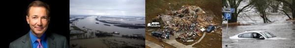
Photo montage credit,
left to right: Missouri flooding: AP Photo/Jeff Roberson; Dallas area
tornado: G.J. McCarthy/The Dallas Morning News via AP; Scotland
flooding: Danny Lawson/PA via AP.


Check out this site Dairy Business to know more about starting a Dairy Business
ReplyDelete