Meteorologist Paul Douglas writes about Minnesota weather daily, trying to go beyond the "highs" and "lows" of the weather story to discuss current trends and some of the how's and why's of meteorology. Rarely is our weather dull - every day is a new forecast challenge. Why is the weather doing what it's doing? Is climate change a real concern, and if so, how will my family be affected? Climate is flavoring all weather now, and I'll include links to timely stories that resonate with me.
Sunday, January 3, 2016
Subzero Outbreak Next Week - 7 Biggest Climate Stories of 2015
29 F. high temperature in the Twin Cities Sunday. 24 F. average high on January 3. 33 F. high on January 3, 2015.
January 4, 1981: Air cold enough to freeze a mercury thermometer pours into Minnesota. Tower hits 45 below zero. January 4, 1971: A snowstorm moves through the Upper Midwest. Winona gets over 14 inches.
January Thaw This Week; Subzero Fling Next Week
Maybe
I'll become a human barometer. You know, the aunt who can feel a storm
coming in her bones; the eccentric uncle who's arthritis acts up when
the weather is changing? Doppler's great but maybe my fractured right
ankle will tip me off to a brewing tornado or biblical flood? Maybe not.
9
days ago I fell on the ice while walking my dog - or as a friend
helpfully suggested: "kick-boxing with Don Shelby". I'm a bit hazy on
the details.
Today will be seasonably cool (the average high now
at MSP is 24F) but we warm into the 30s later this week. 12-24 hours
above freezing the latter half of this week will keep ice thin, sketchy
and unsafe on most lakes. A weak storm pushing across the Midwest will
brush us with a little ice Wednesday, snow on Friday, but any accumulation will be light.
Historically our temperatures bottom out between January 10-17 and right on cue here comes a well-timed subzero slap for next week. We may not climb above 0F Monday, with a chill factor of -25F. Old fashioned cold.
In spite of El Nino January may live up to its bitter reputation again this year.
* Subzero air shows up as bright purple in this 10-day GFS 2-meter temperature prediction, courtesy of NOAA and AerisWeather.
Ouch.
Enjoy this week's continuation of warmer-than-average with a few days
above 32F because next week will arrive like a cold slap across the
face. Temperatures tumble on Sunday, and at least one European model
shows subzero highs 1 week from today. Wind chills next week may dip as
low as -20 to -30F. Source: WeatherSpark.
Mixed Bag of Precipitation by Late Week?
It's still too early for specifics, and I'm not convinced we'll pick up
an inch of precipitation by Friday. With temperatures close to 32F in
the lowest mile of the atmosphere and the surface I could see a mixed
bag of wet snow, even a little freezing rain or drizzle. Source: Aeris
Enterprise.
Snow Potential Increases.
GFS guidance hints at a couple inches of slush later this week, maybe
another shot of snow early next week as subzero air arrives, creating a
powdery, fluffy accumulation. Bitter outbreaks are almost always
preceded by at least a few inches of snow, and this time will probably
be no exception.
Coldest of Winter Next Week?
GFS guidance shows a wake-up temperature of -17F next Thursday morning,
January 14. I do expect some recovery by the third week of January, but
next week will be the real deal; herd-thinning cold.
GFS Numbers.
The European (ECMWF) model suggests the coldest weather will come early
next week, NOAA's GFS model suggesting the core of the polar chill will
hold off until the latter half of next week. Either way there's little
doubt temperatures are about to tumble. Time to dig out the parka.
A Sloppy Jet.
As we've been talking about for a few days the Arctic Oscillation (AO)
has gone sharply negative, meaning a more meandering, wandering polar
vortex - unusual warmth and high pressure over the arctic displacing
bitter air southward into the USA. At some point a mild, El Nino signal
may return, but not before a 3-4 day stretch of frigid weather next
week. Source: GrADS:COLA/IGES.
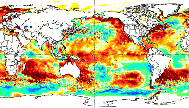
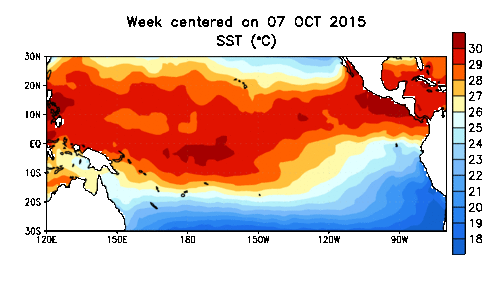
The Most Fascinating Meteorological Images of 2015. The Weather Channel has a story that highlights some of the most eye-popping visuals from last year; here's an excerpt: "...As
2015 ends, global land-plus-ocean temperatures are on track to far
exceed those of any other year in records that date back to the 1880s. A
significant contributor was ocean temperatures, and while the
increasingly strong El Niño in turn contributed to that, there was
plenty of other anomalously warm water, as this sequence of SST (sea
surface temperature) departures from average on the first of each month
illustrates..."
2015 Was One of the Craziest Years Yet for Weather - Here's Why That's So Dangerous. Business Insider reports; here's an excerpt: "...But
we can’t pin it all on El Niño. Yes, a lot of it can be chalked up to
this year’s El Niño, which has been one of the strongest on record. (El
Niño is a regularly occurring event characterised by warmer-than-normal
temperatures in the Pacific Ocean that make it easy for water to gather
in the air into powerful storm systems). Still, many of this year’s
events have likely been made worse by human-made climate change. As decades of research suggest,
a gradually warming climate is also amping up the likelihood and
frequency of extreme events, from flooding to heat waves. Here’s a
rundown of the year’s most freakish weather events, and why they aren’t
set to improve anytime soon..."
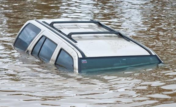
Midwest Floods: Death Toll Rises to 24 as States Take Stock of "Catastrophic" Ruin.
Flooding along the middle Mississippi River has rivaled and in some
cases exceeded the previous high-water mark of 1993. Here's an excerpt
from The Guardian: "As the Mississippi
River and its tributaries retreated from historic winter levels that
flooded towns, forced evacuations and killed two dozen people, residents
in the St Louis area were facing a massive cleanup and recovery effort
that will likely last weeks. The flood, fueled by more than 10in of rain
over a three-day period that began last weekend, is blamed for 24
deaths in Illinois and Missouri..."
Photo credit above: "Petersburg,
Ill., Mayor John Stiltz climbs the nearly 2,000-foot long wall erected
to protect the town's business district from the Sangamon River on
Saturday, Jan. 2, 2016. Illinois Gov. Bruce Rauner of Illinois also
toured flood-ravaged areas Saturday as near-record crest predictions of
the Mississippi River and levee breaks threatened more homes." (Ted Schurter/The State Journal-Register via AP.
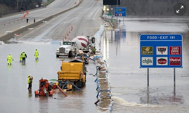
It's Going To Get Ugly: Midwest Calls in National Guard as Flood Disaster Unfolds. Here's a clip from The Guardian: "Floods have submerged towns, roads, casinos and shopping malls around the south and midwest for more than three days,
prompting governors in Illinois and Iowa to call in the National
Guard.Sixteen states issued flood warnings covering some eight million
people. By Saturday floodwaters had begun to subside in many areas,
reopening several important highways, after topping levees in the region
late on Friday. But swollen rivers have yet to crest in southern
states, alarming governors in Tennessee, Louisiana and Mississippi. At
Dardanelle, Arkansas, the National Weather Service recorded the Arkansas river at 41ft, nine feet above flood stage..."
Photo credit above: "Workers from the Missouri department of transportation attempt to pump water off I-55 near Arnold, Missouri on Thursday." Photograph: Sid Hastings/EPA.
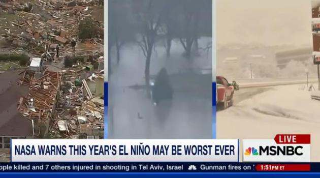
NASA Warns El Nino May Cause "Weather Chaos".
The best way I've heard it described is like going up a flight of steps
(climate change and warming, worldwide) and then standing on your
tip-toes (El Nino). A much warmer Pacific ocean may be turbocharging the
El Nino we're experiencing right now, forecast to linger into at least
spring of 2016. MSNBC has the video and story; here's an excerpt: "Despite
the devastating storms across the country the last few weeks, NASA is
forecasting the worst is yet to come. Michael Mann, author of "Dire
Predictions: Understanding Climate Change" joins to discuss."
Why We'll Keep Having Weird Weather in 2016.
Additional warmth is loading the dice, spiking the punch in favor of
more extreme events. They would have happened anyway, but a warmer
climate is "juicing" the atmosphere, making droughts and floods deeper,
longer and stronger. Here's an excerpt from TIME: "...In
recent years, a weak Arctic Oscillation has allowed cold air to escape
the Arctic, leading to a chilly winter in the Northeast U.S. But the
Oscillation appears to be holding strong, according to NOAA data,
lessening the chance of a chilly winter. Climate phenomena like El Niño
are not new occurrences, but scientists say that global warming has
contributed to making them larger and more damaging. NOAA’s Deke Ardnt
likens climate change to a flight of stairs. “Over time you get higher
and higher,” Ardnt told The Guardian.
“El Niño is like standing on your tippy toes when you’re on one of
those stairs. Both of those together work to create the warmest
temperature on record...”
Total Precipitable Water animation above courtesy of NOAA NESDIS.
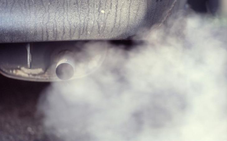
The Dirty Truth about "Clean Diesel". If it sounds too good to be true, chances are it is. Here's an excerpt from an Op-Ed at The New York Times: "...This
diesel pollution is not just unpleasant; it is also dangerous. The
nitrogen oxides produced by diesel engines, which are far more popular
in Europe than in the United States, are a potent irritant for asthma
sufferers. Health officials in Italy also noted increased reports of
cardiovascular disease this week. Diesel exhaust is laden with insidious
soot particles, the so-called PM 2.5 (particulate matter smaller than
2.5 microns, or one-thirtieth the width of a human hair), which allow
carcinogens to penetrate deep into tissues and organs. In other words, a
driver who steps on the accelerator of a diesel car may be filling the
lungs of nearby pedestrians, cyclists, infants in strollers and other
drivers with potentially deadly particulate matter..." (File image: The Telegraph).
How to Cultivate the Art of Serendipity. The New York Times
has a fascinating piece - it's amazing how many things we take for
granted today were discovered (by accident). How do we increase the
chance of random, pleasant surprises? Here's an excerpt: "...A
surprising number of the conveniences of modern life were invented when
someone stumbled upon a discovery or capitalized on an accident: the
microwave oven, safety glass, smoke detectors, artificial sweeteners,
X-ray imaging. Many blockbuster drugs of the 20th century emerged
because a lab worker picked up on the “wrong” information. While
researching breakthroughs like these, I began to wonder whether we can
train ourselves to become more serendipitous. How do we cultivate the
art of finding what we’re not seeking?..."
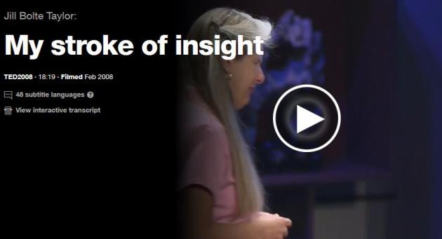
Jill Bolte Taylor: My Stroke of Insight.
A brain researcher has a stroke that ultimately provides more insight
into the workings of the human brain? There's a reason why this TED Talk has over 18 million views. Watch this video - you won't regret it: "Jill
Bolte Taylor got a research opportunity few brain scientists would wish
for: She had a massive stroke, and watched as her brain functions —
motion, speech, self-awareness — shut down one by one. An astonishing
story."
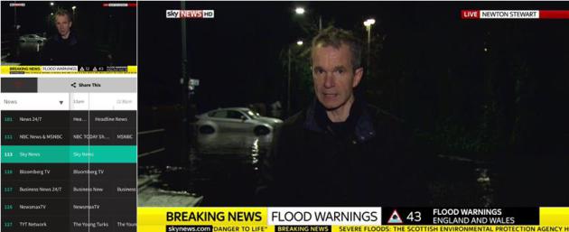
Pluto TV.
Here's another indicator of how fast the television business is
iterating, experimenting and reinventing new ways to aggregate content
(and make it more convenient to watch anytime, anywhere, on any device).
Pluto TV reminds me of the promise of Aereo - no local broadcast
stations, but you can watch NBC (reruns) and MSNBC, Sky News (pictured
above from my iPad), Bloomberg TV, CNET, reruns of Jimmey Kimmel and
Conan, food channels, sports highlights (no ESPN, sorry), even music
channels similar to what you'd see in a cable or satellite bundle. There
are apps for smart phones and tablets, or you can just click over to pluto.tv to watch on your PC or Mac. Pretty cool, and an omen of what's to come.
Getting Coffee With The President.
What do you get when you mix at '63 Stingray Corvette with black
coffee, Jerry Seinfeld and the President of the United States? One of
the funniest 19 minutes of your life. The latest installment of
Seinfeld's "Comediens in Cars Getting Coffee" is brilliant.
TODAY: Mix of clouds and sun, seasonably cool. Winds: S 5-10. High: 26
MONDAY NIGHT: Partly cloudy. Low: 15
TUESDAY: Breezier, turning milder. High: near 30
WEDNESDAY: Flurries, a little ice possible. Wake-up: 25. High: 33
SUNDAY: Temperatures fall through the teens. Winds: NW 10-20. Wake-up: 13. High: 15 (falling)
Climate Stories...
Strange Weather Points to the Potential Impact of Global Warming. The
concern is amplifying and intensifying the weather that would have
happened anyway - wetter storms, deeper, longer droughts, more intense
heat spikes. Here's an excerpt of an Op-Ed from The News and Observer: "Climate
scientists stress that isolated weather events and short-term trends do
not necessarily have a relation to the Earth’s overall climate. But
even cautious scientists and people skeptical about climate change might
feel a stab of worry about the weather of 2015. If the planet is
getting warmer, as an overwhelming majority of scientists agree, then
the year just past gave a stark preview of what may be in store if the
nations of the world cannot halt or slow the trend. Some of the most
vivid evidence of altered weather patterns came at year’s end. Storms
with hurricane-force winds lashed and flooded Northern Europe. Tornadoes
typical of spring came through the South’s tornado alley in early
winter. The Mississippi River, usually low in winter, is so swollen from
relentless rain that it is flooding parts of the Mississippi Valley..."
Read more here: http://www.newsobserver.com/opinion/editorials/article52787220.html#storylink=cpy
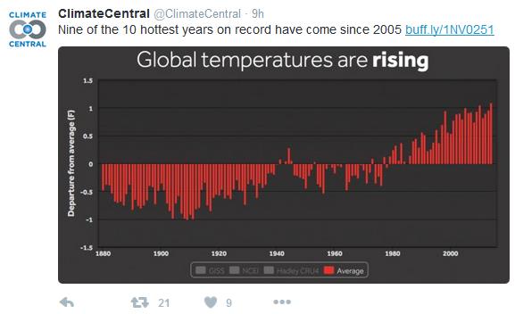
The 7 Most Interesting Climate Findings of the Year. Climate Central has a recap of some of the most noteworthy research and findings of 2015; here's an excerpt: "...But
there are a baker’s half dozen studies that really piqued our interest
this year, from the Atlantic circulation slowdown to the disappearance
of the global warming slowdown. While the seven were all fascinating and
critical, some also created controversies that are still ongoing.
The finding:We could be entering an era of warming unseen in at least 1,000 years. Why it made the list: The rate of global warming has increased with each passing decade. A couple of studies
published this year show that the rate will not only continue to rise,
but soon be one the earth hasn’t seen since the Vikings found their way
to Greenland (and possibly longer than that). Warming will be fastest in
the northern hemisphere, which just so happens to be where most humans
live..."
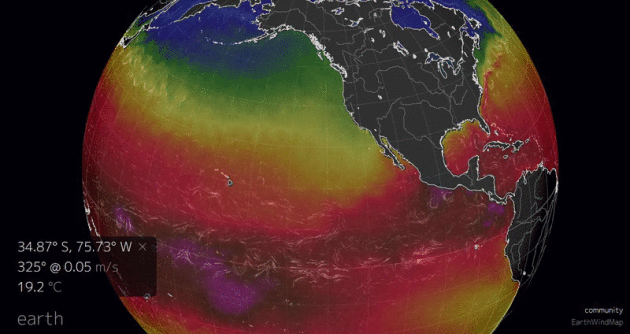
2015: A Year of Progress and Buffoonery on Climate Change. Here's a clip from a Washington Post article: "...We may, too, be getting a taste of what a warming world feels like. According to a 2014 paper, one potential effect is a doubling of the number of strong El Niño years.
That’s the phenomenon that has perturbed the jet stream and pushed this
winter’s temperatures up. Though the El Niño variation predated human
influence, it, among many other natural cycles, probably will not be
immune to it. And even if this year’s El Niño cannot be blamed squarely
on climate change, it nevertheless feels like a fitting end to a
remarkable year in the policy and politics of global warming..." (Image: earth.nullschool.net).
What's Ahead for Climate Change in 2016? Here's a snippet from a story at Discovery News: "...In
2015, Hawaii became the first state to pass a law making such a
commitment. That law requires the state to get all of its electricity
from renewables by 2045. In December, San Diego became the largest city in
the country to make that commitment, requiring all of the city’s power
to come from renewables by 2035. Others have made less ambitious
commitments, but no less significant. A law passed in California
requires the state to obtain 50 percent of
its electricity from renewables, excluding hydropower. New York City
and San Francisco have also pledged to increase their use of renewables,
and smaller cities, such as Burlington, Vt., have already gone 100 percent renewable, mainly through the use of large amounts of hydropower..." (File image: NASA).
MSU Study: Climate Change Denial Messaging Works. Michigan Public Radio has the story and study results; here's the intro: "Attacking the science behind climate change effectively sways public opinion, according to a recent study by
Michigan State University researchers. MSU associate professor and
sociologist Aaron McCright led the study of 1600 US adults. McCright
says messages that frame climate change as a public health or national
security threat, or even through a “positive” frame like economic
opportunity or religious obligation, seem to fall flat..."


No comments:
Post a Comment