Thanks to Tayler Anderson for this picture, where spring seems to have sprung in Portland, OR. This is definitely a major tease for me as I've had a recent itch to get planting. It's nice to see stuff growing again, no matter where it's happening!

40s in mid-February? A Little Rain by Friday
By Paul Douglas
"Spring is when you feel like whistling even with a shoe full of slush" joked Doug Larson. At the rate we're going there won't be much slush left in your yard by late week. Wednesday will be cool, but daytime highs top 40F Thursday into Saturday.
As snow melts - due to a higher sun angle and more consistent puffs of Pacific air - more of the sun's energy will go into heating up the air. We'll see more snow in March, but March snows tend to be wet, slushy and fickle, with rapid melting and less disruption to your commute (unless we get a cool foot, which could happen).
Going forward the best chance of (significant) snow will come immediately after an arctic outbreak, as jet stream steering winds buckle, pushing a soggy southern storm into the Upper Midwest. Studying the latest models that scenario is unlikely into early March.
Rain showers may sprout by Friday before Canadian air returns next week; highs in the 20s by early next week.
No, spring is NOT right around the corner. But Saturday afternoon we'll get a fleeting taste of lukewarm days to come. We're turning the corner.
_______________________
Extended Forecast
TUESDAY NIGHT: Mostly cloudy. Winds: NW 5-10. Low: 11.
WEDNESDAY: Peeks of cool sun. Winds: ENE 5. High: 24
WEDNESDAY NIGHT: Mostly cloudy. Winds: SSE 5-10. Low: 17.
THURSDAY:Gray and windy with a little drizzle. Winds: SE 15-30. High: 40
FRIDAY: Mild with a few rain showers. Winds: W 10-25. Wake-up: 37. High: 44.
SATURDAY: Some sun, vague hints of stpring? Winds: W 5-10. Wake-up: 33. High: 46
SUNDAY: Cooler wind, few flurries. Winds: WNW 5-10. Wake-up: 31. High: 35
MONDAY: Partly sunny, closer to average. Winds: WNW 5-10. Wake-up: 22. High: 28.
TUESDAY: Mostly cloudy, drama-free. Winds: NW 5-15. Wake-up: 14. High: 29.
________________________
This Day in Weather History
February 17th
1981: Warm weather continues across Minnesota with a record high of 55 in the Twin Cities. Crocuses were blooming.
1894: The Minneapolis Weather Bureau journal notes: 'Sleighing is very poor, about half of the vehicles are on wheels'.
_______________________
Average High/Low for Minneapolis
February 17th
Average High: 30F (Record: 55F set in 1981)
Average Low: 14F (Record: -20F set in 1936)
_______________________
Sunrise/Sunset Times for Minneapolis
February 17th
Sunrise: 7:11am
Sunset: 5:43pm
*Daylight gained since yesterday: ~2mins & 57secs
*Daylight gained since winter solstice: ~1hr & 47mins
______________________
Moon Phase for February 17th at Midnight
3.0 Days Since First Quarter
____________________________
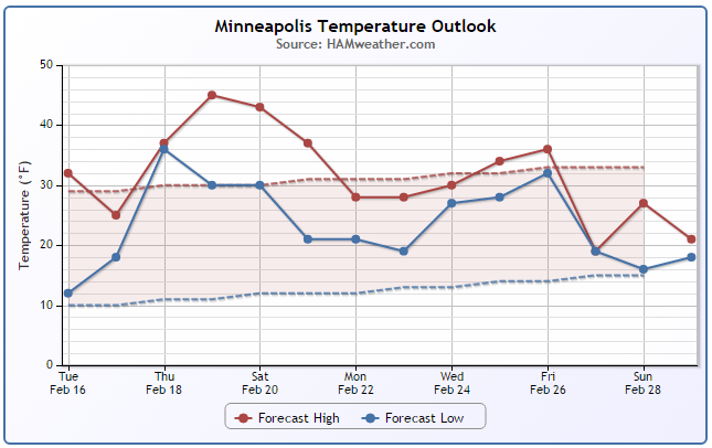
Minneapolis Temperature Trend
Temperatures have gradually been warming over the last few days. In fact by Friday, the air temperature will have warmed nearly 50F since the -6F low temperature we had on Saturday morning in the Twin Cities. High temperatures on Friday will likely spike into the 40s across much of the state and perhaps once again on Saturday. After a couple of March-like days Friday and Saturday, temperatures will settle back to more normal late February levels through much of next week.
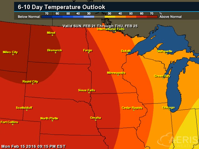
6 to 10 Day Temperature Outlook
According to NOAA's CPC, the 6 to 10 day temperature outlook still suggests warmer than average temperatures in place over the Midwest from February 10th - 25th. However, it appears the warmest weather for us will likely be in place by this Friday.
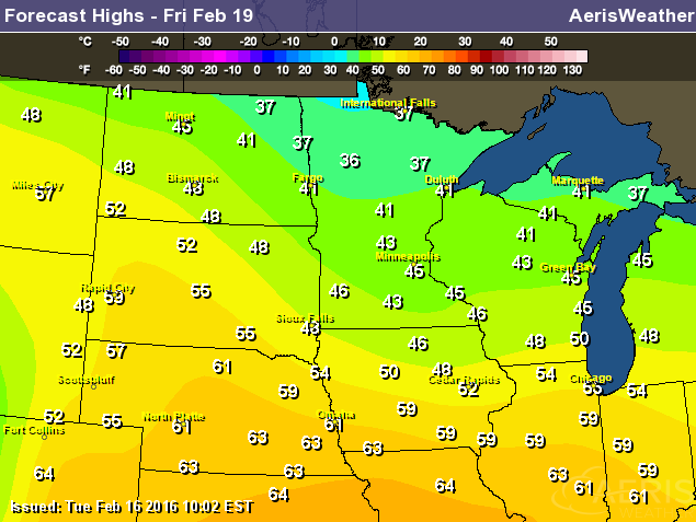
High Temperatures Friday, February 19th
Hints of March will be with us on Friday as highs warm into the 30s and 40s across the state. note that there appears to be widespread 50s and 60s across the Plains and Central U.S.!
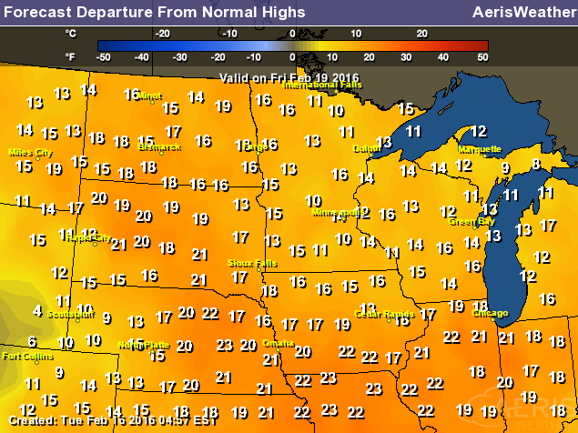
Highs From Average Friday, February 19th
Note that high temperatures on Friday will be running nearly 10F to 20F+ above average across much of the Midwest. There may even be a few locations that get to/near record warmth territory.
_________________________________________
Wednesday Weather Outlook
Temperatures on Wednesday will be a little cooler in the wake of a fast moving clipper that was pretty trivial in it's delivery of precipitation across the Midwest. High will fall back into the 20s across much of the state with feels like temperatures in the single digits and teens by midday.
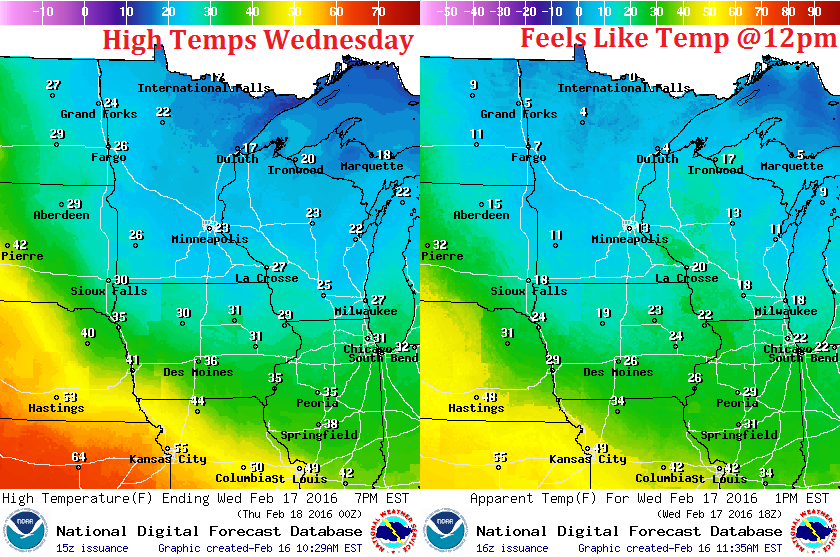
Wednesday Weather Outlook
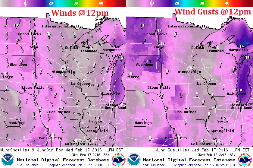
South to southeasterly winds will also be pretty trivial by midday Wednesday. However, winds will pick up on Thursday allowing milder temperatures will push north into the Upper Midwest.
Wednesday Weather Outlook
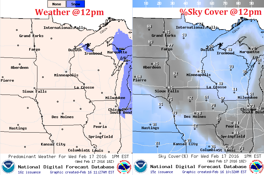
Cooler, drier air will help to clear skies a little more across the region. Note that sunnier skies will be found across the eastern portion of Minnesota and much of Wisconsin by midday Wednesday.
__________________________________
Simulated Radar
The simulated radar suggests another weak clipper rolling through a very narrow sliver of the Midwest PM Tuesday - AM Wednesday. Most areas will stay dry, but there could be a light coating of snow across parts of the Dakota, far SW Minnesota and into Iowa.
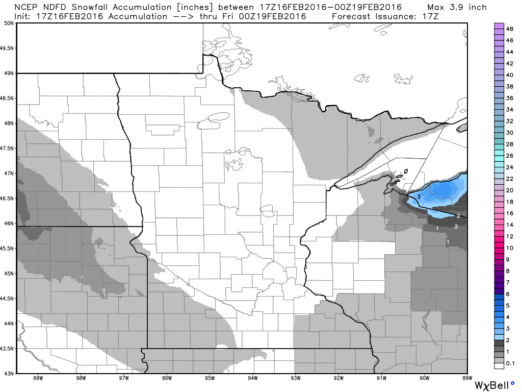
Minnesota Snowfall Potential
Snowfall potential with our next weak clipper PM Tuesday - AM Wednesday will be less than impressive. Note that there may be a little light accumulation from the Dakotas into SW Minnesota.
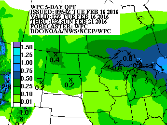
5 Day Precipitation Forecast
According to NOAA's WPC, the 5 day precipitation forecast suggests a little moisture returning to the Upper Midwest through the early weekend. Interestingly, it appears that temperatures will be warm enough for rain showers!! However, it may be cold enough right along the international border for a bit of a wintry mix
____________________________________
National Weather Outlook
The storm system that brought severe storms, flooding rain, heavy snow and ice to parts of the Eastern U.S. will continue moving out of the region. Quieter weather will funnel in behind it over the next couple of days, but note the more active weather moving in from the Western U.S.. This particular system will not only help to bring copious amounts of moisture to places in the West, but it will also be responsible for a mighty warm up in the Central U.S. over the coming days.
Eastern Pacific Precipitable Water Loop
The moisture currently moving into the Western U.S. is an extension of a deep plume of moisture stretching from near the Hawaiian Islands. Because of this, moisture amounts in the Western U.S. will be fairly heavy.
5 Day Precipitation Outlook
According to NOAA's WPC, the 5 day precipitation forecast suggests heavy moisture moving back into the Western U.S.. There is a possibility of 3" to 6"+ liquid, the heaviest of which will be found across the higher elevations
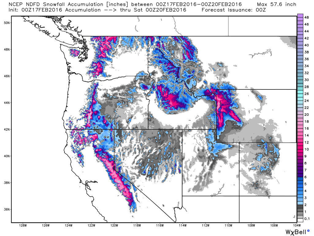
Western Snowfall Potential
Here's the western snowfall potential through 6pm Friday. Note that some spots in the higher elevations from the Sierra Nevada Range to the Northern Cascades could see 12"+ snowfall!
_______________________________
Severe Storm Earlier This Week
WOW! Take a look at this video form ABC Action News - WFTS - Tampa Bay from Pompano Beach, FL on Tuesday morning.
See the video here from ABC Action News - WFTS - Tampa Bay HERE:

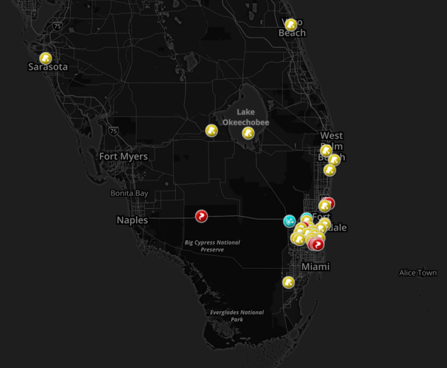
Storm Reports From Tuesday, February 16th
Here's a closer look at the storm reports from AM Tuesday across parts of southern Florida.
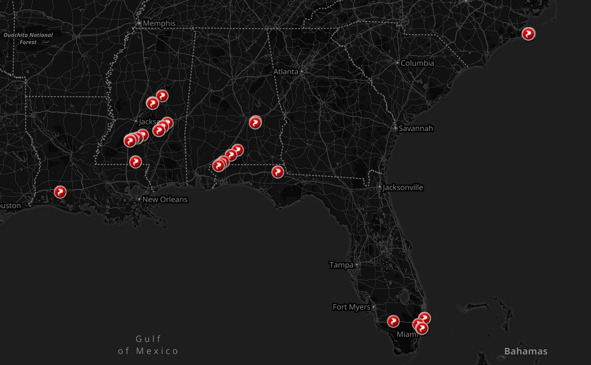
Tornado Reports Since Monday
The storm system that brought heavy snow and ice to places in the Northeast was also responsible for several tornado reports across the Southeastern U.S. since Monday.
Thanks for checking in and have a great rest of your week!
@TNelsonWX

No comments:
Post a Comment