Saturday's cold weather really made me yearn for a nice summer day. I imagined myself digging in the garden, on the golf course or enjoying a few warm rays in a lawn chair. Don't get me wrong, I love *most* things that come with the cold and snowy weather too, but I was really itchy for warm weather. Thanks to Randy Musil for the picture below out of Surprise, AZ. He was a full-time resident of Minneasota until 2 years ago and now calls the AZ fairways his home. FORE! Some of the recent warm and record setting high temps in the Western U.S. will begin nudging east. Parts of the Central and Eastern U.S. will start seeing some of this modified warmer weather through the week ahead.

Spring is Right Around the Corner?
LOL @NWSAlbuquerque!! Interestingly, meteorological spring starts in about weeks (March 1st). That will mark the date when the average 3 coldest months are behind us in the northern hemisphere. Also note that we are only about 5 weeks away from the vernal equinox (March 20th), which marks the official start to spring.

Somewhat Snowy Sunday Ahead
"Snow will develop over the Dakotas and push eastward this evening and tonight, overspreading the region by Sunday morning. The snow will diminish west to east Sunday afternoon. Accumulations of 3 to 6 inches are expected across portions of western and southern Minnesota, with amounts tapering off to the north and east."
Light Snowfall Today - Hints of March by Late Week
By Paul Douglas
There are no coincidences. It's amazing how the right people cross your path when they're supposed to: teachers, mentors and personal heroes.
I stumbled upon Barry ZeVan (The Weatherman) in 1982, working at a national cable news channel in Connecticut. When a position became available at Channel 11 Barry encouraged me to go for it. "You will LOVE Minnesota: the people, the lakes. Oh, there's plenty of manic weather, too" he laughed. He was right. Barry has a new book out on Amazon: "My Life Among the Giants, A Memoir". It's a fun, poignant, worthy read. Thank you Barry.
No serious drama cooking on the maps, just an inch or two of fresh snow Sunday - plowable amounts over southwestern Minnesota. Another clipper whips up a coating Tuesday, but the big weather story is a jolt of Pacific air, warming us to 40F by Friday with a few rain showers possible - vague hints of what's to come. We end the month on a relatively mild note which should spill into March.
Saturday was the 10th day of subzero chill this winter. Average is 23 days. It may have been the last subzero swipe of winter.
_____________________________________________
Extended Weather Outlook
SATURDAY NIGHT: Clouds increase, flurries late. Winds: SE 5-15. Low: 4.
SUNDAY: Couple inches of snow, slick roads. Winds: SE 10-15. High: 21.
SUNDAY NIGHT: Snow tapers early. Cloudy. Winds: SE 5-10. Low: 19.
MONDAY: Mostly cloudy and milder. Wind: SSW 5-10. High: 33
TUESDAY: Still gray, a few flurries. Winds: NNW 5-10. Wake-up: 22. High: 29
WEDNESDAY: Partly sunny and cooler. Winds: NE 5. Wake-up: 10. High: 22
THURSDAY: Overcast, windy and milder. Winds: SE 10-20. Wake-up: 13. High: 37
FRIDAY: Vague hints of spring. Rain shower? Winds: WSW 10-15. Wake-up: 33. High: 41.
SATURDAY: Drier day, a few sunny peeks. Winds: NW 5-10. Wake-up: 32. High: 37
_______________________________________________
This Day in Weather History
February 14th
1923: A 'Black Dust Blizzard' ends after two days. Dirt blown into the state from North Dakota created drifts.
_______________________________________________
Average High/Low for Minneapolis
February 14th
Average High: 49F (Record: 50F set in 1882)
Average Low: 12F (Record: -25F set in 1875)
_______________________________________________
Sunrise/Sunset Times for Minneapolis
February 14th
Sunrise: 7:16am
Sunset: 5:39pm
*Daylight gained since yesterday: ~2mins & 53secs
*Daylight gained since winter solstice (December 20th): ~1hr & 37mins
________________________________________________
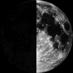
Moon Phase for February 14th at Midnight
0.0 Days Before First Quarter
_______________________________________________
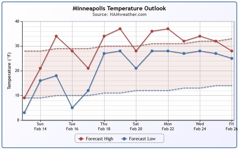
Minneapolis Temperature Trend
After a cold end of the week/early weekend, temperatures will be warming to at/above average levels again through the next several days. In fact, the extended forecast through much of the second half of the month suggests a milder trend with high temperatures mainly in the 30s to near 40F at times.
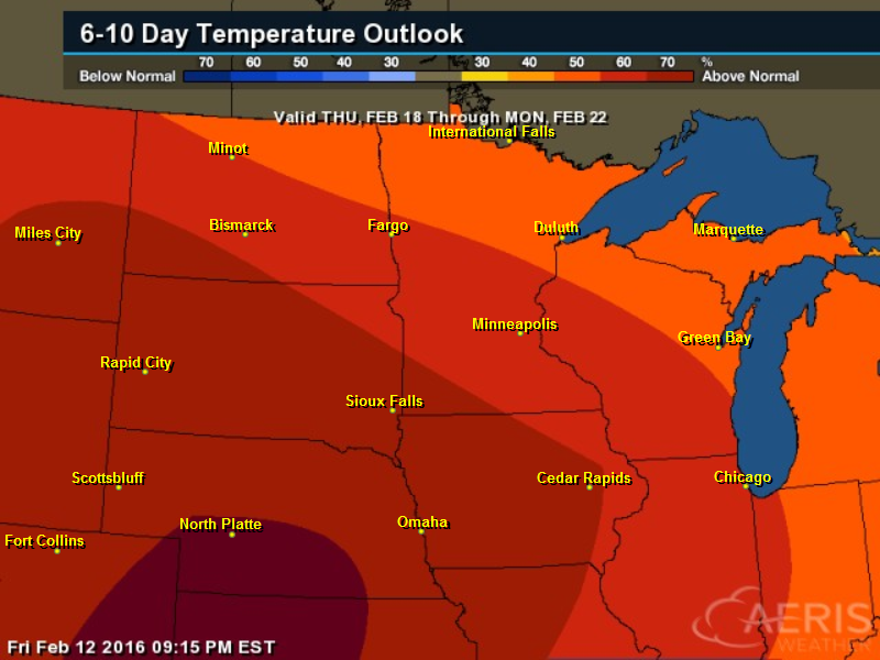
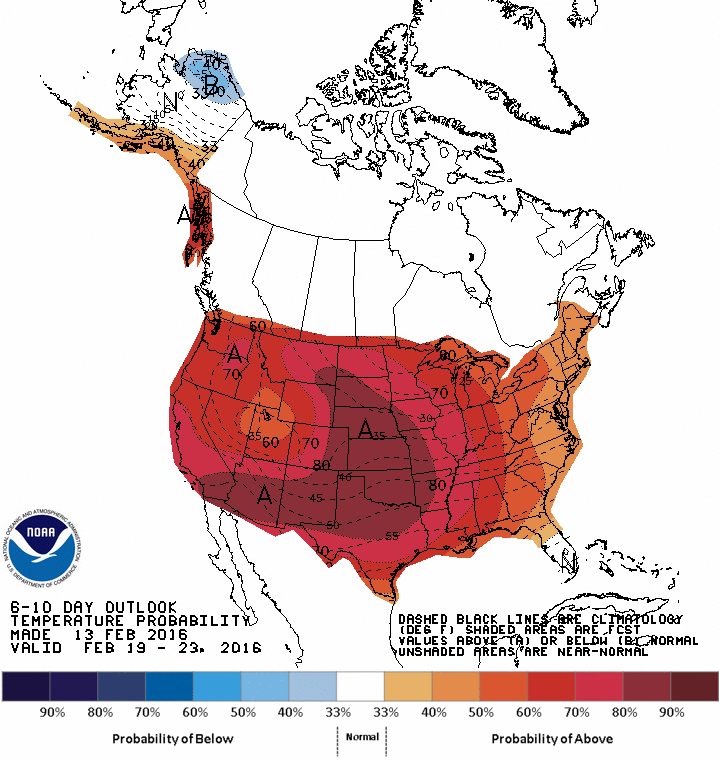
6 to 10 day Temperature Outlook
According to NOAA's CPC, the 6 to 10 day temperature outlook suggests warmer than average temperatures through the 3rd weekend of February. In fact, there could even be hints of March returning at points through the second half of February.
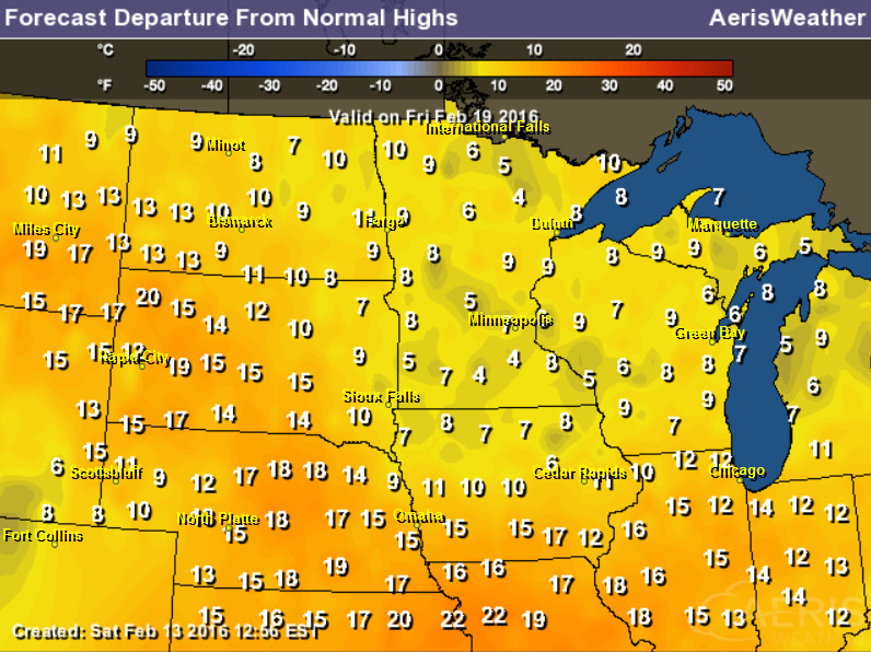
Highs From Average Friday, February 19th
High temperatures on Friday, February 19th will be running nearly 5F to 15F above average across much of the Upper Midwest
__________________________________
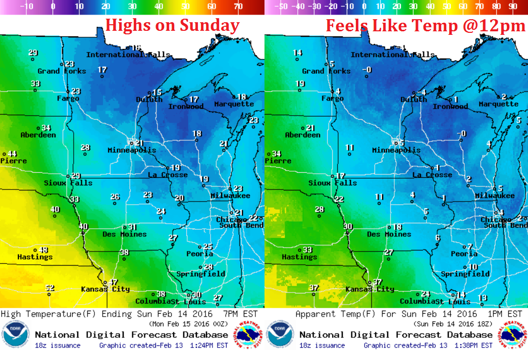
Sunday Weather Outlook
High temperatures on Sunday will be quite a bit warmer than they were on Saturday. Most locations will warm into the 10s and 20s, but feels like temperatures will still be in the single digits above and below 0F across the state.
Sunday Weather Outlook
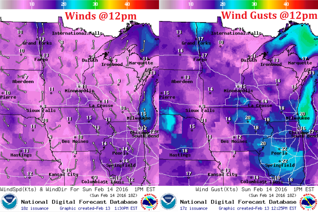
Winds on Sunday will be a little stronger as our next clipper moves through the region. Sustained winds of 10-15mph with guests approaching 20mph will be possible across some the rural areas of western Minnesota and into Iowa.
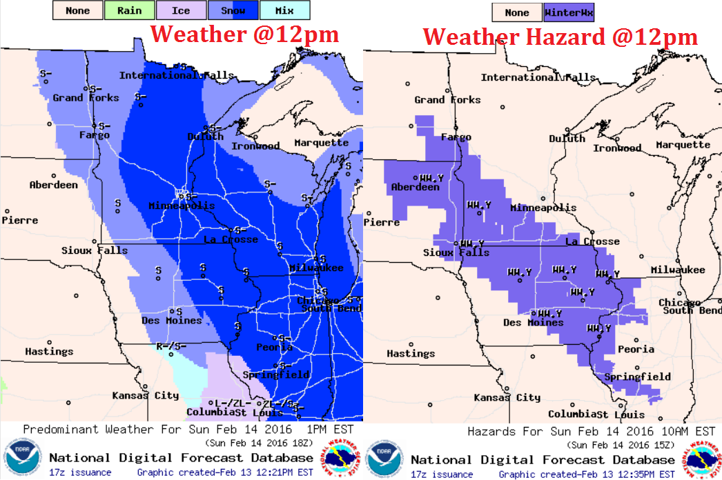
Sunday Weather Outlook
Snow will gradually drift through the region on Sunday with the heaviest band of shovelable/plowable snow setting up from the eastern Dakotas into Southwestern MN and central/eastern Iowa.
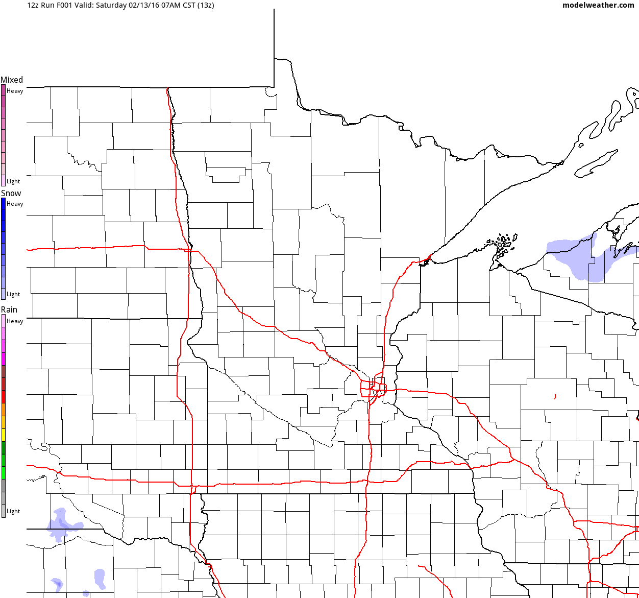
Simulated Radar
The simulated radar from AM Saturday to PM Monday shows our next clipper rolling through the region on Sunday. Snowfall accumulations with this particular system will be heavier across southwestern Minnesota.
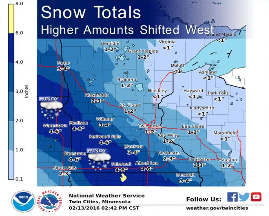
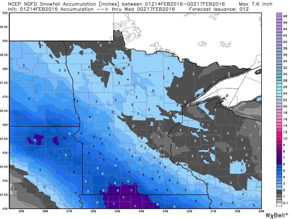
Snowfall Potential
Snowfall potential through 6pm Monday shows the heaviest snowfall of 3" to near 6" possible from eastern portions of South Dakota through Southwestern Minnesota. Lighter amount of up to 1" to 2" will be possible from central and northern Minnesota to Wisconsin.
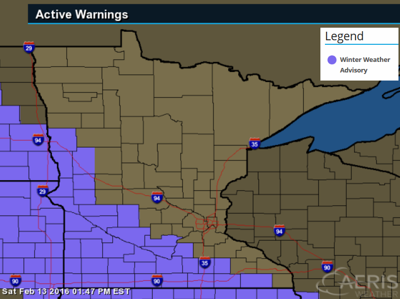
Winter Weather Advisory
...SNOW AND PATCHY BLOWING SNOW TONIGHT AND SUNDAY MORNING...

.A WINTER WEATHER ADVISORY REMAINS IN EFFECT FOR MUCH OF WEST
CENTRAL THROUGH SOUTH CENTRAL MINNESOTA FROM 9 PM THIS EVENING TO
NOON SUNDAY. SNOW WILL SPREAD ACROSS THE AREA THIS EVENING AND
PERSIST INTO SUNDAY MORNING. SNOWFALL AMOUNTS OF 3 TO 5 INCHES ARE
EXPECTED. WHILE THIS OCCURS...SOUTHEAST WINDS FROM 15 TO 25 MPH
WILL DEVELOP ALONG WITH GUSTS TO AROUND 30 MPH. THE SNOW AND WIND
WILL LEAD TO SOME BLOWING AND DRIFTING SNOW.
...WINTER WEATHER ADVISORY REMAINS IN EFFECT FROM 9 PM THIS
EVENING TO NOON CST SUNDAY...

* EXPECT SNOW TO DEVELOP BETWEEN 9 PM AND MIDNIGHT AND THEN
  DIMINISH AROUND NOON ON SUNDAY.

* THE HEAVIEST SNOWFALL RATES WILL OCCUR BETWEEN MIDNIGHT AND 6
  AM SUNDAY.

* TOTAL SNOW ACCUMULATIONS OF 3 TO 5 INCHES ARE EXPECTED.

* LOOK FOR REDUCED VISIBILITIES AT TIMES.

* PLAN ON SLIPPERY ROAD CONDITIONS.
________________________
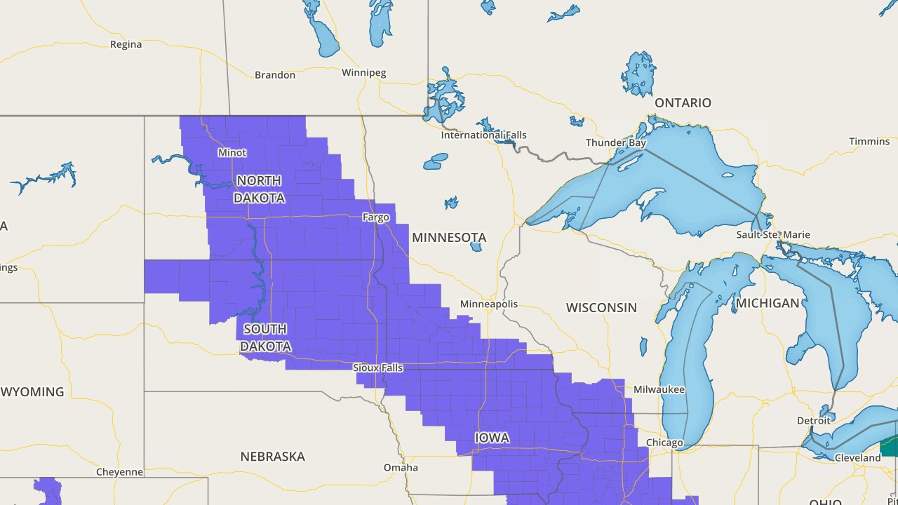
Midwest Snowfall Potential
As the clipper dives southeast through the Midwest, wintry precipitation and snowfall accumulations will be possible. Note that Winter Weather Advisories stretch from the Dakotas to parts of the Ohio Valley.
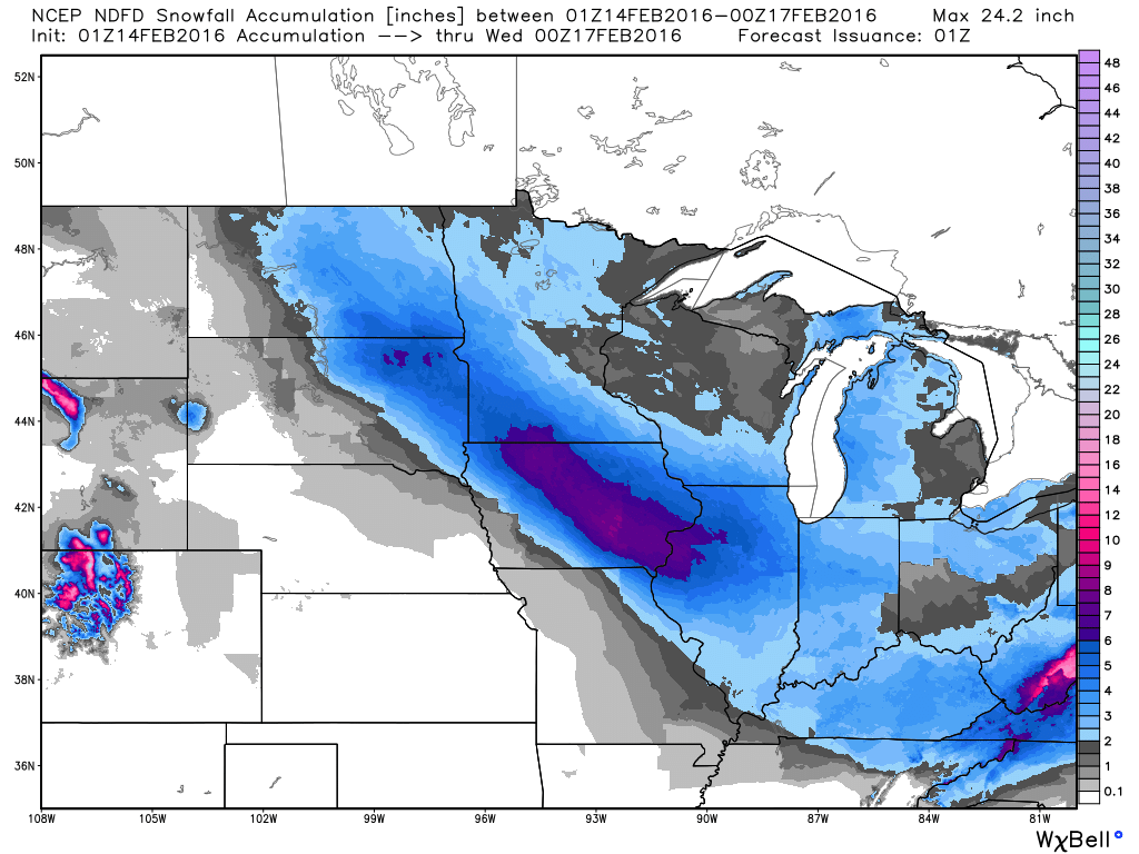
Midwest Snowfall Potential
Here's a look at the snowfall potential across the Midwest through 6pm Monday. Note the sharp cutoff on the southern edge of the snow band.
_____________________________________
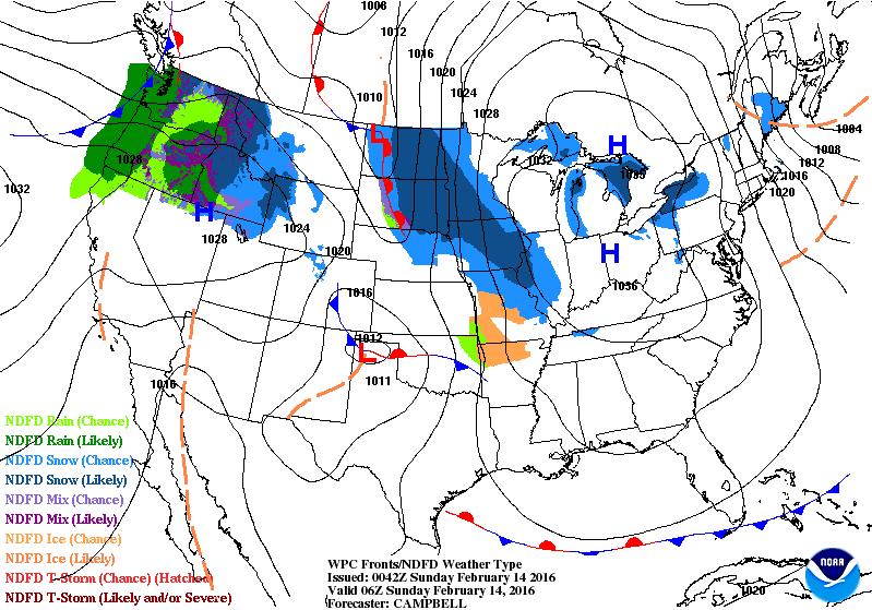
National Weather Outlook
Note the band of accumulating snow diving through the Midwest through early next week. Interestingly, this appears to be meeting up with another impulse of energy to create a much larger and waterlogged storm system that will impact the Eastern U.S. with heavier rain and wintry precipitation.
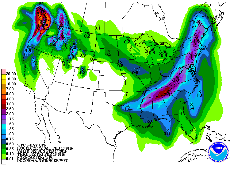
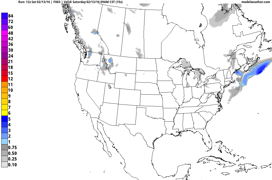
5 Day Precipitation Outlook
According to NOAA's WPC, the 5 day precipitation outlook shows a fairly decent band of precipitation from the Lower Mississippi Valley/Gulf Coast States to parts of the Northeast.
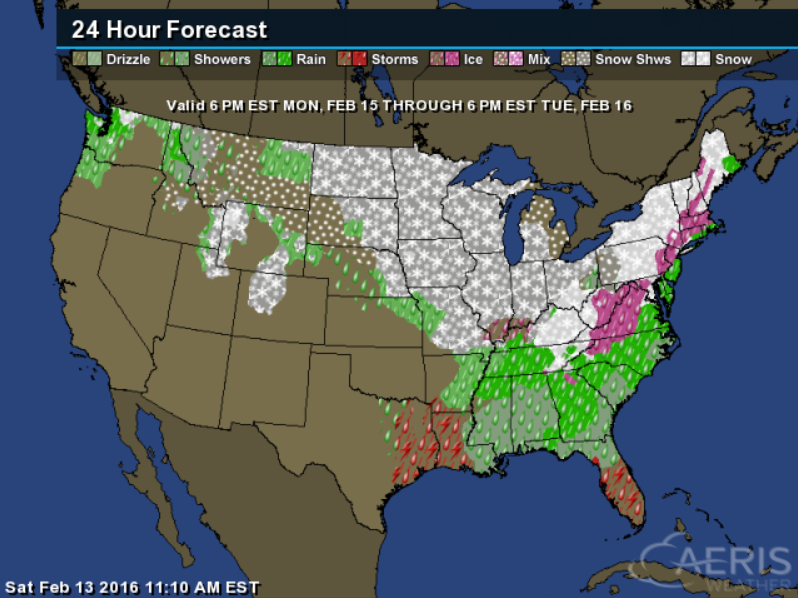
East Coast Storm
Here's a look at the weather map from 6pm Monday to 6pm Tuesday. Note that there appears to be wintry precipitation from the Ohio Valley/Mid Atlantic to the Northern New England States, while heavier rain and thunder will be possible farther south.
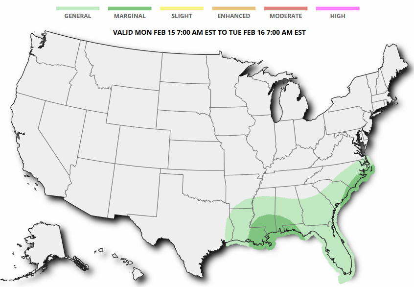
Severe Weather Chances Monday?
According to NOAA's SPC, there is a marginal risk of a few strong to severe storms across parts of the Gulf Coast and Mid Atlantic States on Monday as the storm system intensifies across the eastern part of the country.
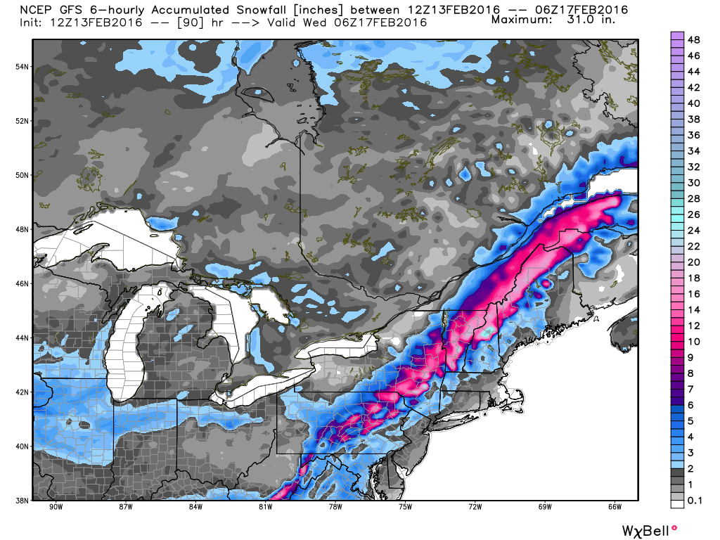
Northeast Snowfall Potential
As the storm system develops and swings into the Eastern U.S., snowfall chances will increase. Note how the snow band starts in the Midwest and lifts back into the northeastern part of the country.
Northeast Snowfall Potential
Here's a closer look at the snowfall potential across the northeastern part of the country. Note that there appears to be a heavier band of snow that develops over parts of the Appalachians and moves into the Northern New England states. Some of this could be heavy enough to shovel and plow across a fairly wide area through early/mid week.
__________________________________
6 to 10 Day Temperature Outlook
According to NOAA's CPC, the 6 to 10 day temperature outlook suggests warmer than average temperatures across much of the nation from February 19th-23rd. This mild temperature trend will likely melt a lot of snow across the nation through the second half of the month.
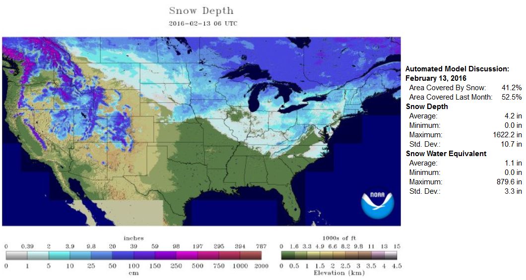
National Snow Depth
According to NOAA's NOHRSC, about 41% of the nation was covered in snow on February 13th. It'll be interesting to see how this map changes over the coming days as warmer weather starts to move in. I have a hunch that this map will look quite a bit different by this time next weekend.
____________________________
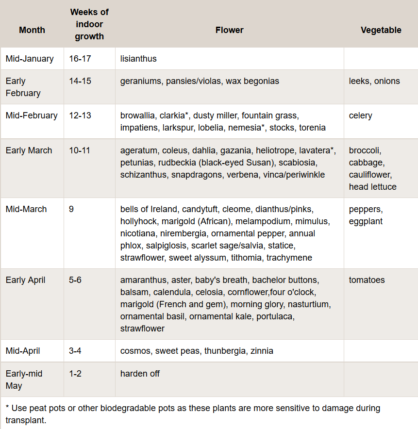
Starting Seeds Indoors
It's getting to be about that time of the year to start thinking about starting seeds indoors. If you're an experienced seed starter, you're probably getting the itch. If you're new to it and thinking about starting this year, now is a good time to start your research. The U of M has some tips on how you can start.
See more HERE:
_______________________________________
Thanks for checking in and have a great rest of your weekend! Don't forget to follow me on Twitter @TNelsonWX

No comments:
Post a Comment