56 F. average high on April 12.
75 F. high on April 12, 2015.
Trace of rain yesterday at KMSP.
Trace of snow reported.
April 13, 1949: A late-season snowstorm dumps over 9 inches in parts of the Twin Cities metro area.

Tell Me a Story - Spring Back on Fast-Forward!
"The history of storytelling isn't one of simply entertaining the masses but of also advising, instructing, challenging the status quo" wrote Therese Fowler. It's in our collective DNA to respond to stories.
"The history of storytelling isn't one of simply entertaining the masses but of also advising, instructing, challenging the status quo" wrote Therese Fowler. It's in our collective DNA to respond to stories.
I
use Twitter, but context, analysis and perspective will never quite fit
into a 140-character tweet. I have yet to meet a Minnesotan who doesn't
have a story, anecdote or opinion about the weather.
I look forward to chatting up severe weather with Vineeta Sawker at the Star Tribune, today at noon. Please, only easy questions. I'm serious.
Our
temporarily-stunted spring gets a lime-green makeover in the days to
come as temperatures push toward 70F. I predict precious little will get
done the next 3-4 days. Saturday looks mild and springy; a growing chance of showers Sunday into Tuesday as a storm lifts north across the Plains. A free lawn-watering. Nothing severe, not yet. Give it 2-3 weeks.
Speaking
of stories, now is a good time to review a severe storm action plan
with your kids. Where would you go, what would you do? If you're
prepared you can weather anything.
Hennepin County Apologizes for 6 AM Wake-Up Sirens.
There's no tornado, but get your butt out of bed! Just wait until
hackers figure out how to do this. Here's a video link and story excerpt
at Star Tribune: "Residents
across Hennepin County got an early wake up call Tuesday morning when
civil defense sirens sounded just after 6 a.m. Sirens sounded all across
the state’s most populous county despite there being no emergency or
weather issues, said Jon Collins, a county spokesman. “It was a false
alarm,” he said. The sheriff’s office, in a statement, said the sirens
are tested internally daily — a test that does not sound the sirens.
Tuesday there was a “momentary computer hardware malfunction during the
daily test,” the statement said. The system has since been repaired and
is functioning normally..."
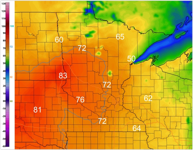
4 PM Thursday.
NOAA's 4 KM NAM (technically: NEMS NMMB 4K NAM Conus Nest if anyone
asks) predicts low 70s for the metro by mid-afternoon Thursday; a shot
at 80F over west central Minnesota. Job productivity and test scores
will suffer. Source: AerisWeather.
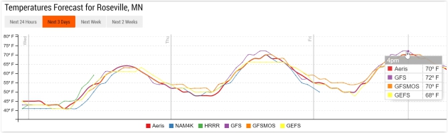
Friday: Distractingly Nice.
If you can't sneak out today or tomorrow Friday should be just as nice,
in theory, with low 70s in the Twin Cities metro area. Winds will be
gusty, but few will be whining about the weather. Source: Aeris
Enterprise.
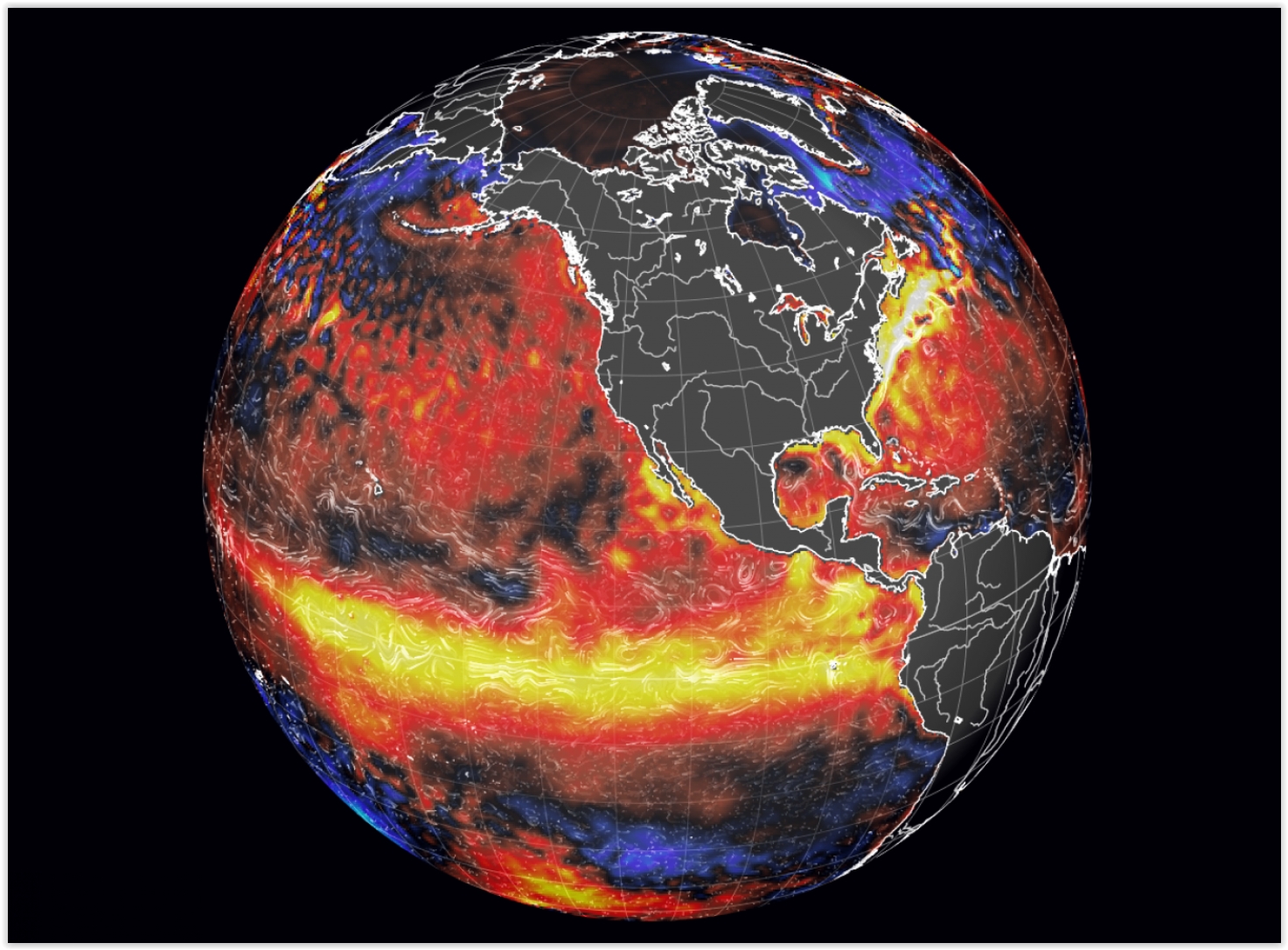
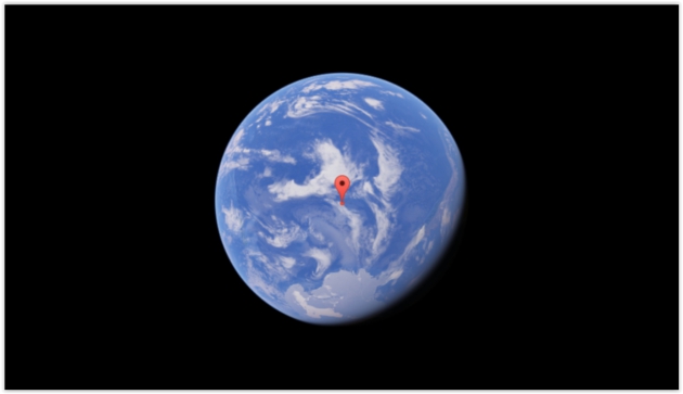
"Godzilla" El Nino is Dead.
And now there's at least a 50% probability of a La Nina cooling phase
by late summer or autumn, according to NOAA. Here's the introduction to a
story at Capital Weather Gang: "It
was going to be an El Niño to end all El Niños. The warmest ocean
temperature anomalies on record blossomed in its core, the largest
area of exceptionally warm water ever seen in the tropical Pacific. The
California drought was death watch — it would bring
“one storm after another like a conveyor belt.” It was named Godzilla.
And now it’s dead. RIP, Godzilla El Niño. Over the past few weeks, the
equatorial Pacific has been cooling..."
Image credit: "Bye-bye, El Niño." (earth.nullschool.net)
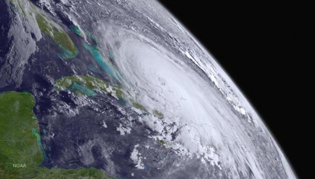
More Active Atlantic Hurricane Season Forecast for 2016.
Based on sliding into a La Nina phase of ENSO, which favors lighter
winds over the tropics - increasing the potential for hurricane
development in the Caribbean and Atlantic. At some point the "hurricane
drought" will come to a crashing end. Here's an excerpt from MSN.com: "Early
forecasts from meteorologists suggest the 2016 Atlantic hurricane
season will be more active than normal partly because of the expected
end of the El Nino weather pattern in the next few months. Weather
forecasters have linked the El Nino phenomenon, which is a warming of
the water in the central Pacific Ocean, to weak hurricane seasons in the
Atlantic. The current El Nino, which started early last year, was the
strongest since 1997 and is expected to end in the late spring or early
summer, according to the U.S. Climate Prediction Center..." (File image of Hurricane Joaquin: NOAA).
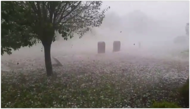
Tree-Shredding, Window-Breaking Hail. Seems relevant during Severe Weather Awareness Week in Minnesota. Check out the video from CBS Dallas' Facebook site: "Incredible
Hail Video - So much for a relaxing day off! CBS11 photojournalist Jake
Shannon just sent us this video of hail crashing through his living
room windows in Wylie..."
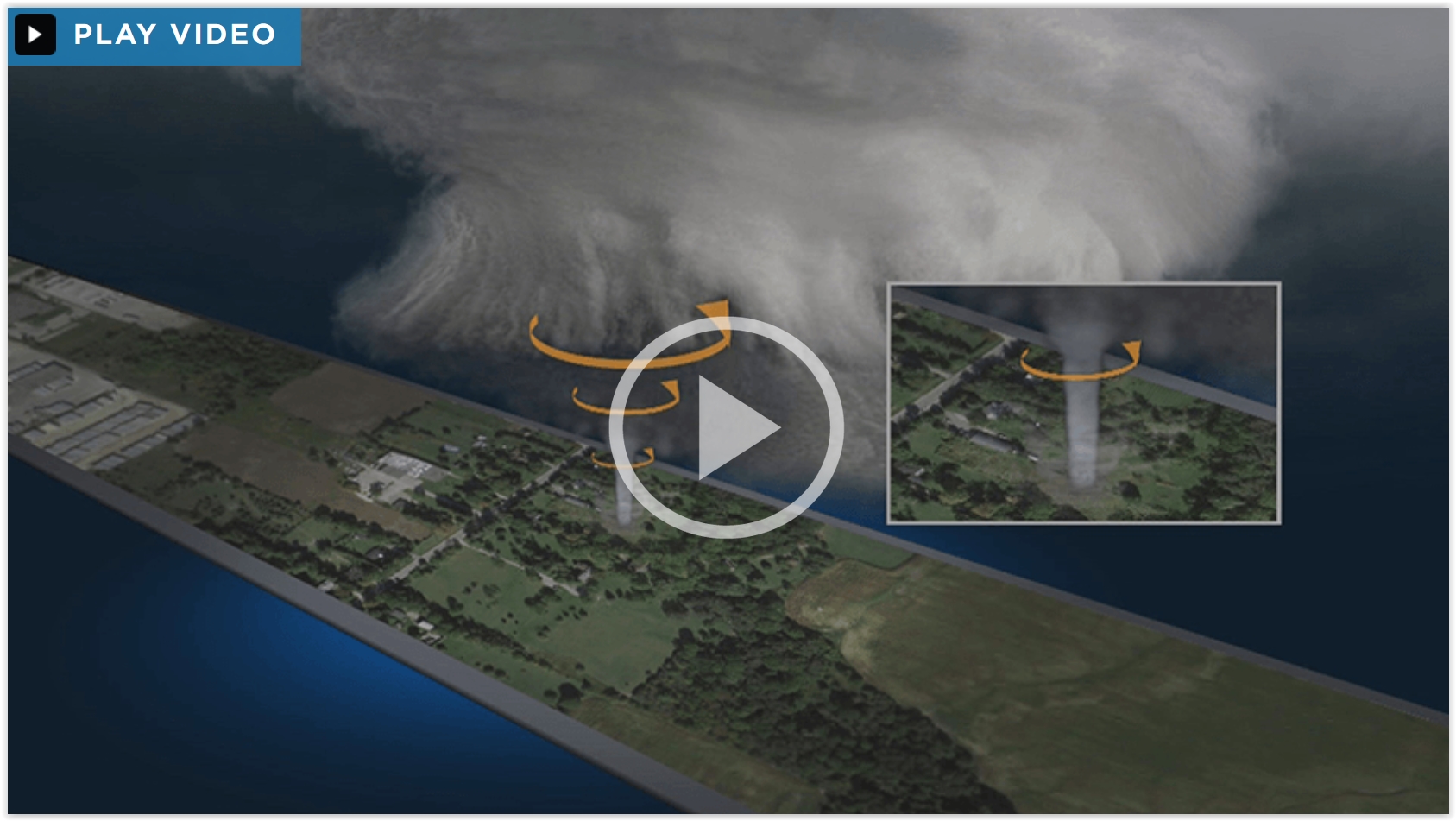
The Science Behind Tornadoes. What They Are and How They Form. A tornado isn't so much an object as a "process". Here's some very good advice from Canada's Globalnews.ca: "...And
while the public is fascinated with tornadoes, stopping to record one
can put you in extreme danger. Even though you might think the tornado
is at a safe distance, it’s important to remember that there is no safe
distance: the tornado could change direction (it’s often difficult to
tell in which direction it’s moving) and the main source of injury and
death isn’t the tornado itself, but the debris that can be flung at
great distances and at tremendous speeds."
10 Damaging Facts About the Fujita Scale. Tornadoes are rated based on the extent of damage they inflict; here's an excerpt from Mental Floss: "...The
Enhanced Fujita Scale is as much about engineering as it is about the
weather. Meteorologists teamed up with engineers to figure out just how
strong winds have to be to cause certain levels of damage. They use 28 different categories to survey damage
to objects ranging from trees and barns to sturdy buildings like
schools or prisons. For example, a tornado collapsing the walls at a box
store like Walmart would likely make the tornado an EF-3
with winds near 140 mph. If a tornado struck a hospital and deformed
the entire structure, the expected wind speeds would be in excess of 200
mph, making the tornado an EF-5..."
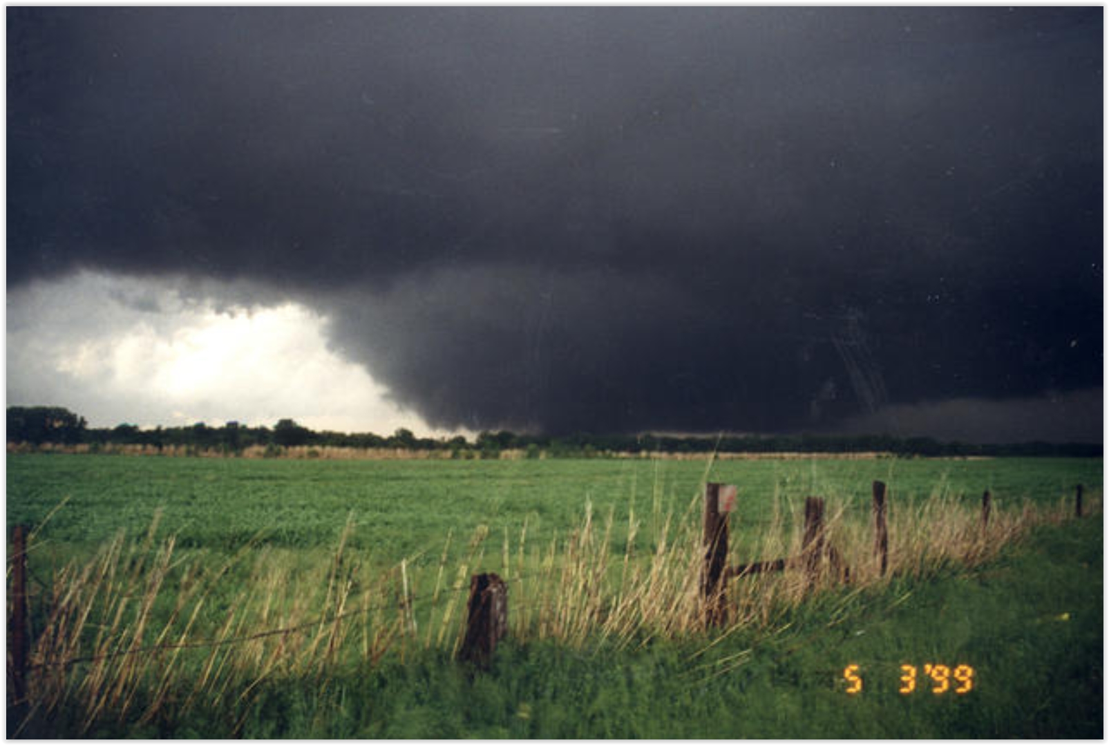
Photo credit above: "An F5 tornado approaches Oklahoma City on May 3, 1999." Image credit: NSSL NOAA via Flickr | CC BY-ND 2.0.
NASA Snaps 3-D Pics of Weather From Space. Here's the intro to an interesting story posted at space.com: "You
might assume that all raindrops are the same, but scientists say that's
not the case. And they now have the pictures to prove it. Thanks to a
research effort by NASA and the Japan Aerospace Exploration Agency,
researchers have taken the first 3-D snapshots of precipitation - both
raindrops and snowflakes - from the vantage point of space. The pictures
were taken from the GPM Core Observatory, a satellite launched in 2014
that's a collaboration between the two nations..."
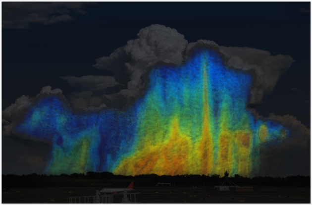
Image credit above: "This
image shows how the size and distribution of raindrops varies within a
storm. Blues and greens represent small raindrops that are 0.5-3.0
millimeters in size. Yellows, oranges and reds represent larger
raindrops that are 4-6mm in size. A storm with a higher ratio of
yellows, oranges and reds will contain more water than a storm with a
higher ratio of blues and greens." Credit: NASA/Goddard.
This
image shows how the size and distribution of raindrops varies within a
storm. Blues and greens represent small raindrops that are 0.5-3.0
millimeters in size. Yellows, oranges and reds represent larger
raindrops that are 4-6mm in size. A storm with a higher ratio of
yellows, oranges, and reds will contain more water than a storm with a
higher ratio of blues and greens.
Credit: NASA/Goddard - See more at: http://www.space.com/32471-nasa-3d-pics-weather-from-space-gpm.html#sthash.5bk6w3qI.dpuf
You
might assume that all raindrops are the same, but scientists say that's
not the case. And they now have the pictures to prove it.
Thanks to a research effort by NASA and the Japan Aerospace Exploration Agency, researchers have taken the first 3-D snapshots of
precipitation — both raindrops and snowflakes — from the vantage point
of space.
Exploration Agency, researchers have taken the first 3-D snapshots of
precipitation — both raindrops and snowflakes — from the vantage point
of space.
The pictures were taken from the GPM Core Observatory, a satellite launched in 2014 that's a collaboration between the two nations. GPM's mission is to gain a better understanding of Earth's water and energy cycles and provide better forecasting of extreme events that cause natural disasters.
- See more at: http://www.space.com/32471-nasa-3d-pics-weather-from-space-gpm.html#sthash.5bk6w3qI.dpuf
Thanks to a research effort by NASA and the Japan Aerospace
Exploration Agency, researchers have taken the first 3-D snapshots of
precipitation — both raindrops and snowflakes — from the vantage point
of space.The pictures were taken from the GPM Core Observatory, a satellite launched in 2014 that's a collaboration
between the two nations. GPM's mission is to gain a better understanding of Earth's water and energy cycles and provide better forecasting of extreme events that cause natural disasters.- See more at: http://www.space.com/32471-nasa-3d-pics-weather-from-space-gpm.html#sthash.5bk6w3qI.dpuf
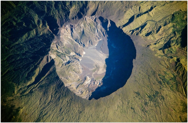
Image credit above: "This detailed astronaut photograph depicts the summit caldera of the Tambora volcano." Photograph: NASA Earth Observatory.
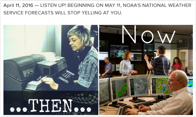
National Weather Service Will Stop Using All Caps In Its Forecasts. HOORAY! Here's an excerpt from NOAA: "New
forecast software is allowing the agency to break out of the days when
weather reports were sent by “the wire” over teleprinters, which were
basically typewriters hooked up to telephone lines. Teleprinters only
allowed the use of upper case letters, and while the hardware and
software used for weather forecasting has advanced over the last
century, this holdover was carried into modern times since some
customers still used the old equipment..."
National Weather Service Forecasts "Will Stop Yelling At You". More perspective at The New York Times.
The Absurd Primacy of the Automobile in American Life.
Will our grandkids or great grandkids look back and wonder "what were
they thinking?" We'll see. Here's an illuminating excerpt from a story
at The Atlantic: "...A
big part of why they’ve stuck around is that they are the epitome of
convenience. That’s the allure and the promise that’s kept drivers
hooked, dating all the way back to the versatile, do-everything Ford
Model T. Convenience (some might call it freedom) is not a selling point
to be easily dismissed—this trusty conveyance, always there, always
ready, on no schedule but its owner’s. Buses can’t do that. Trains can’t
do that. Even Uber makes riders wait. But convenience, along with
American history, culture, rituals, and man-machine affection, hide the
true cost and nature of cars. And what is that nature? Simply this: In
almost every way imaginable, the car, as it is deployed and used today,
is insane..."
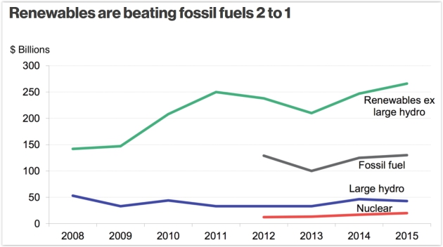
Graphic credit above: "Investment in Power Capacity, 2008-2015" Source: BNEF, UNEP.
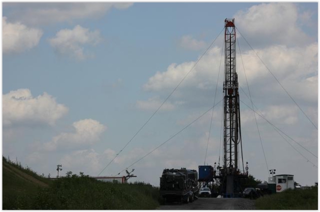
Image credit: WCN 24/7 / Flickr.

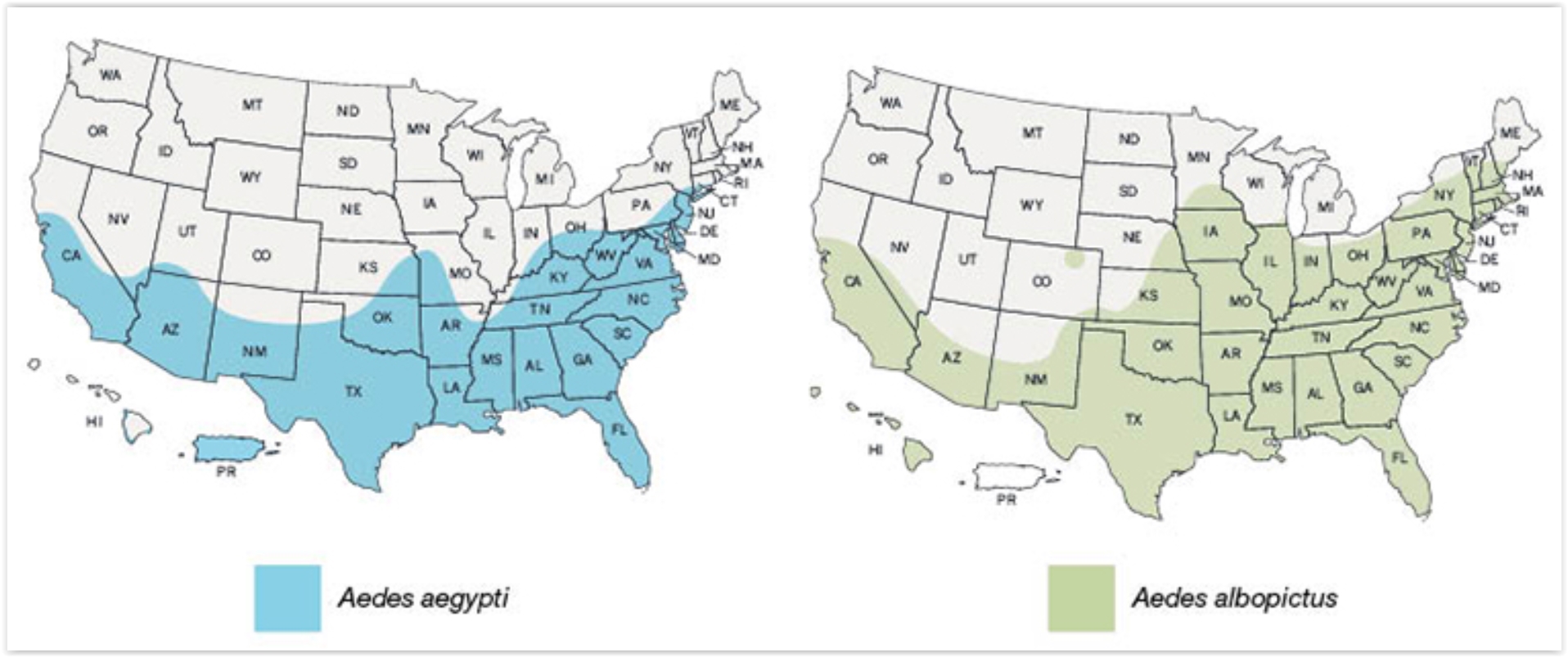
A Zika Catastrophe Could Rival Hurricane Katrina. Alarmist hype? I sure hope so. Here's an excerpt of a story at The Atlantic: "...Hotez also points to the poorest urban areas of coastal Texas, Louisiana, Mississippi, Alabama, and South Florida as particularly at-risk. “This could be a catastrophe to rival Hurricane Katrina or other recent miseries that disproportionately affect the poor,” he wrote in an essay for The New York Times on Friday. Which means that scientists and doctors shouldn’t be the only officials scrambling to plan for a potential public-health crisis. Because a vaccine for Zika won’t be developed in time for this year’s mosquito season—if ever—Hotez says aggressive mosquito-control and environmental cleanup is urgently needed, especially in poor urban areas..."
Map credit above: "The estimated range for two species of mosquitoes that could spread Zika in the United States." (CDC)
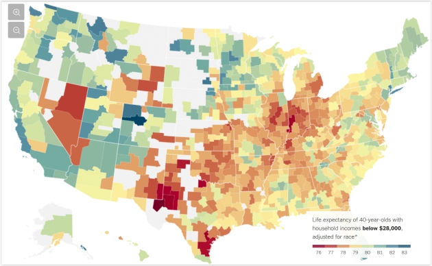
The Rich Live Longer Everywhere. For The Poor, Geography Matters. Here's an excerpt from an eye-opening story at The New York Times: "...The
poor in some cities — big ones like New York and Los Angeles, and also
quite a few smaller ones like Birmingham, Ala. — live nearly as long as
their middle-class neighbors or have seen rising life expectancy in the
21st century. But in some other parts of the country, adults with the
lowest incomes die on average as young as people in much poorer nations
like Rwanda, and their life spans are getting shorter. In those
differences, documented in sweeping new research,
lies an optimistic message: The right mix of steps to improve habits
and public health could help people live longer, regardless of how much
money they make..."
Image credit: Animations by Lisa Larson-Walker. Images via Flickr CC.


TODAY: Partly sunny, balmy. Winds: S 8-13. High: 67
WEDNESDAY NIGHT: Clear to partly cloudy. Low: 50
THURSDAY: Blue sky, feels like May. Winds: S 10-20. High: 71
FRIDAY: Gusty with fading sun, punching out early. Winds: S 15-25. Wake-up: 53. High: 72
SATURDAY: Lukewarm sun, the nicer day of the weekend. Winds: S 10-20. Wake-up: 56. High: 72
SUNDAY: Peeks of sun, stray T-shower? Winds: SE 8-13. Wake-up: 55. High: 71
MONDAY: Better chance of showers, T-storms. Winds: E 10-20. Wake-up: 57. High: 68
TUESDAY: Periods of rain, a bit cooler. Winds: E 10-15. Wake-up: 50. High: 59
Climate Stories...
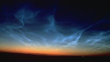
File image of noctilucent clouds: NASA.
NASA: Global Warming Is Now Changing How Earth Wobbles. Nothing to worry about here folks - please move along! Here's an excerpt from AP and Sci-Tech Today: "Global warming is shifting the way the Earth wobbles on its polar axis, a new NASA study finds. Melting ice sheets -- especially in Greenland -- are changing the distribution of weight on Earth. And that has caused both the North Pole and the wobble, which is called polar motion, to change course, according to a study published Friday in the journal Science Advances. Scientists and navigators have been accurately measuring the true pole and polar motion since 1899 and for almost the entire 20th century they migrated a bit toward Canada. But that has changed with this century and now it's moving toward England, said study lead author Surendra Adhikari at NASA's Jet Propulsion Lab..."
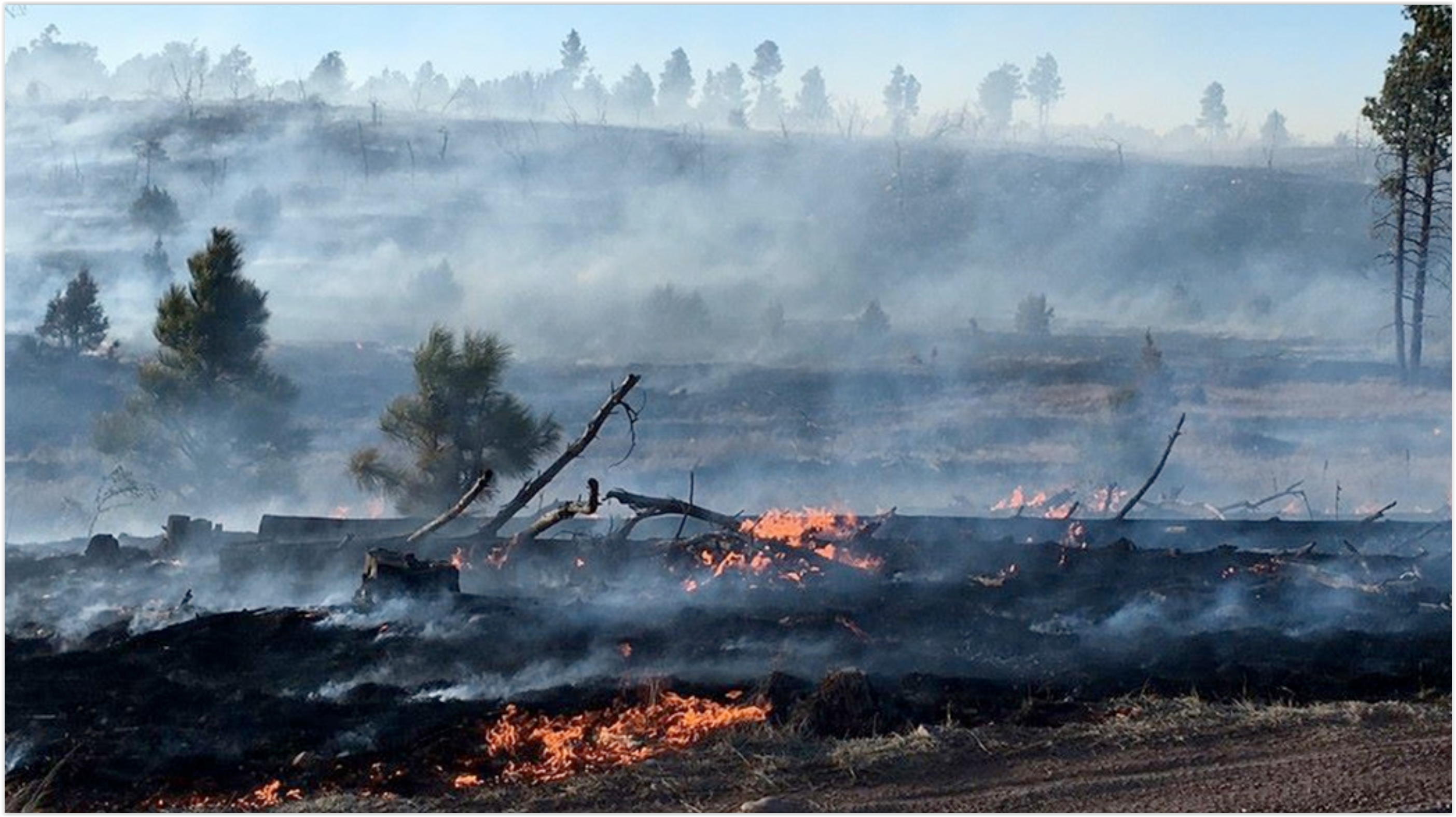
Wildfires, Once Confined to a Season, Burn Earlier and Longer. Here's a snippet from The New York Times: "...Fires, once largely confined to a single season, have become a constant threat in some places, burning earlier and later in the year, in the United States and abroad. They have ignited in the West during the winter and well into the fall, have arrived earlier than ever in Canada and have burned without interruption in Australia for almost 12 months. A leading culprit is climate change. Drier winters mean less moisture on the land, and warmer springs are pulling the moisture into the air more quickly, turning shrub, brush and grass into kindling. Decades of aggressive policies that called for fires to be put out as quickly as they started have also aggravated the problem. Today’s forests are not just parched; they are overgrown..."
Photo credit above: "A wildfire burned in an area northeast of Phoenix in March. Officials across the country say they are preparing for a difficult fire season this year." Credit Heber-Overgaard Fire District
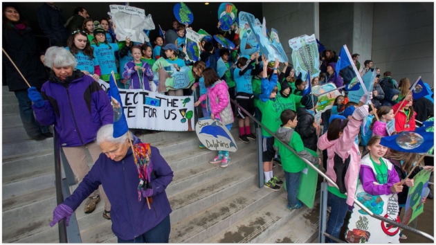
Photo credit above: "Students from Edison Elementary School joining climate change activists in front of the Wayne Morse Federal Courthouse in Eugene, Oregon on March 9, 2016." Image: Brian Davies/The Register-Guard via AP.
No comments:
Post a Comment