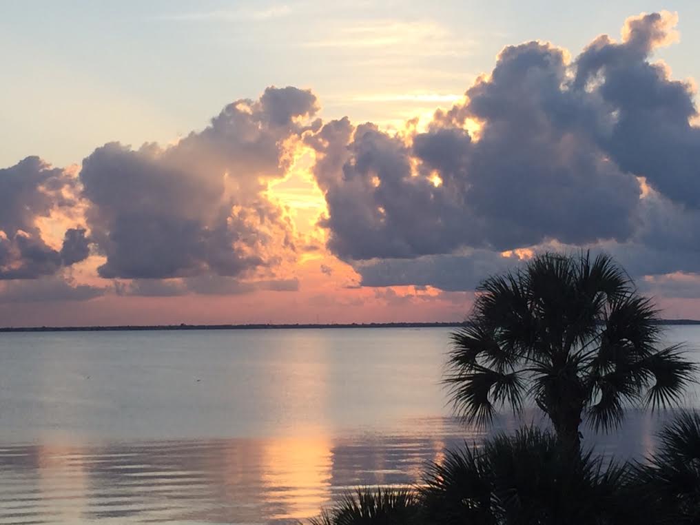
Florida Sunset
Thanks
to my good friend Jim Plucinak for this picture out of Cape Canveral,
FL. This was the sunset on Sunday night... what are you trying to rub it
in, Jim? HA! Thanks for the picture! It looks amazing there!
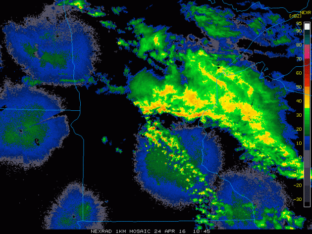
Sunday Morning Storms
Sunday
started off on a fairly noisy note. Scattered showers and storms pushed
through metro during the morning hours, here is the radar loop showing
the unsettled weather. There were even reports of lightning striking
houses on the northwest side of the Twin Cities.
____________________________________
Cool, Wet Week - Feels Like Early April Again
By Todd Nelson, filling in for Douglas.
Cheerful birds, green grass and popping leaves, it's really starting to look like spring! Now, if it would only feel like spring again, then we'd be set!
Here's the thing, we'll be dancing in and out of showers this week with temperatures running 5 to nearly 10 degrees below average as a parade of Pacific storms sail through the Central U.S.. We'll be on the cooler side of these storm systems with cool rain chances today and again midweek.
Weather conditions look ripe for a potential severe weather outbreak on Tuesday across the Plains and again Wednesday across the Mississippi River Valley. This may be the first 'big' outbreak since Groundhog Day in early February.
Even though weather conditions won't be very ideal for us this week, the soaking rains will really help in the long run! The spring green up is well on its way. Unfortunately, I don't see our next wave of warm sunshine until early May. In the meantime, keep those light jackets and something waterproof handy. Cool, active weather will take us through the end of April.
_____________________
Extended Forecast
SUNDAY NIGHT: Scattered showers, a few rumbles of thunder. Winds: E 10-15. Low: 57.
MONDAY: Cloudy and wet, rumble of thunder early. Winds: ENE 10-15. High: 63.
MONDAY NIGHT: Lingering clouds and showers. Winds: NNE 10. Low: 40
TUESDAY: Cool breeze. A few spits. Winds: E 10-15. High: 54.
WEDNESDAY: Breezy. Cool rain returns. Winds: E 10-15. Wake-up: 40. High: 52.
THURSDAY: AM sprinkle. Slow PM clearing. Winds: ENE 10-15. Wake-up: 38. High: 54
FRIDAY: More sun, feels better. Winds: NE 5-10. Wake-up: 40. High: 61.
SATURDAY: Clouds thicken, late PM shower. Winds: E 10-15. Wake-up: 44. High: 60.
SUNDAY: AM sprinkles, more PM sun. Winds: Wind: NE 10-15. Wake-up: 42. High: 60.
_________________________
_________________________
This Day in Weather History
April 25th
April 25th
1996:
Heavy snow falls over northern Minnesota, including 10 inches of snow
at Baudette. The International Falls Airport is forced to close for only
the second time in history.
_________________________
_________________________
Average High/Low for Minneapolis
April 25th
April 25th
Average High: 63F (Record: 91F set in 1962)
Average Low: 42F (Record: 25F set in 1907)
__________________________
Average Low: 42F (Record: 25F set in 1907)
__________________________
Sunrise/Sunset Times for Minneapolis
April 25th
April 25th
Sunrise: 6:11am
Sunset: 8:11pm
Sunset: 8:11pm
*Daylight gained since yesterday: ~2mins & 50secs
*Daylight gained since winter solstice: ~5hours & 15mins
______________________________
*Daylight gained since winter solstice: ~5hours & 15mins
______________________________
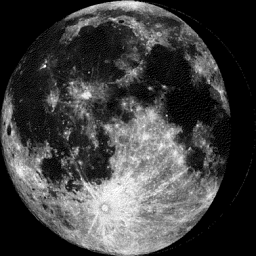
Moon Phase for April 24th at Midnight
3.9 Days Before Last Quarter
3.9 Days Before Last Quarter
________________________________
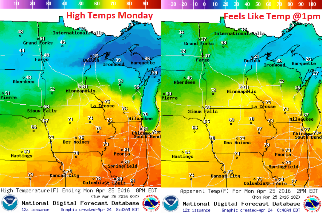
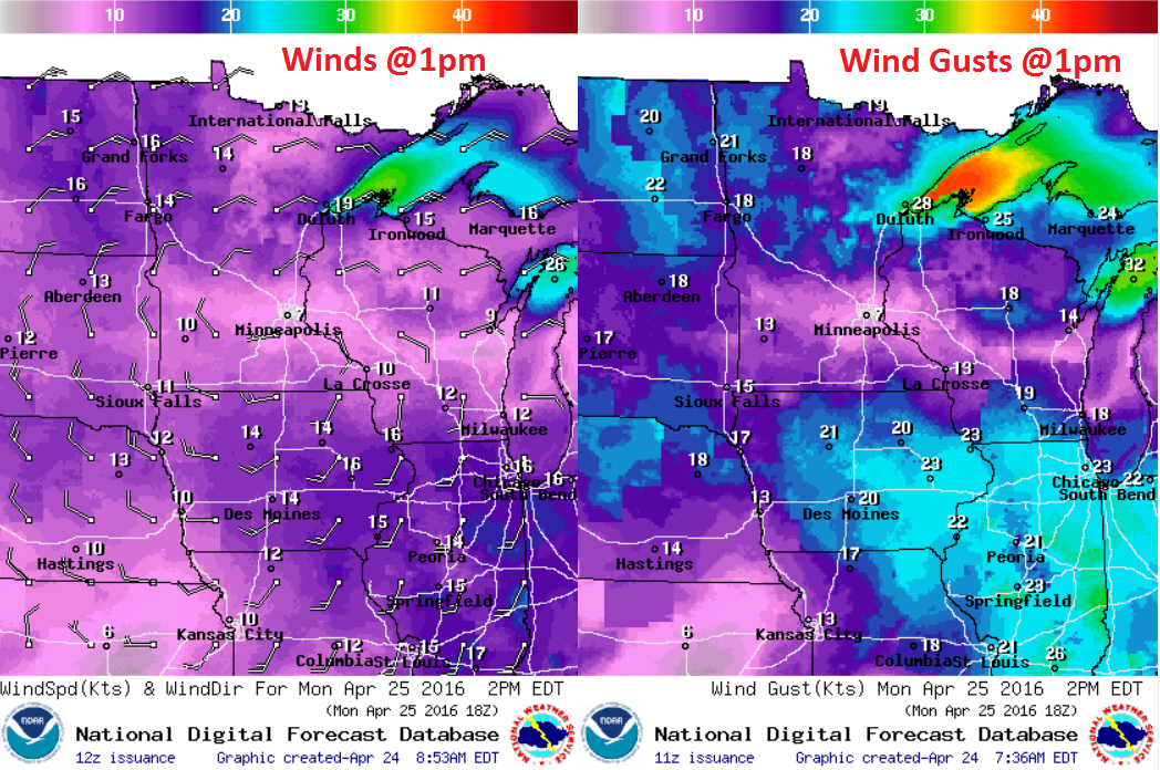
Monday Weather Outlook
High
temperatures on Monday will be quite a bit cooler than what we had over
the weekend. The storm system responsible for scattered showers and
storms on Sunday will begin sagging southeast Monday with cooler
temperatures settling in behind it. Highs across much of the state will
be in the 40s and 50s with a few 60s still possible in the southeastern
part of the state.
Monday Weather Outlook
Winds
appear to be a little lighter over central and southern Minnesota as
the center of low pressure moves through the area. However, winds
surrounding the low across the northern part of the state and into Iowa
look a bit stronger.
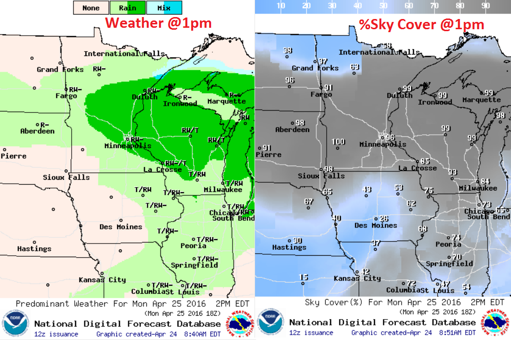
Monday Weather Outlook
Monday
still looks like a soggy day across the region with cloudy skies and
lingering rain showers. The heaviest rainfall will begin to fade through
the day as the storm system continues sagging southeast through the
region.
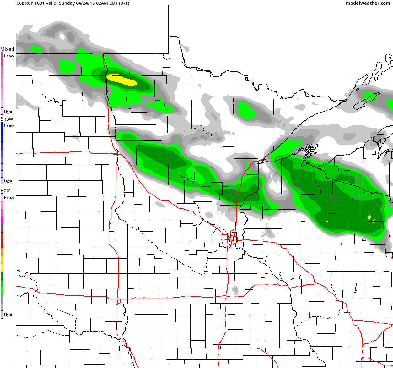
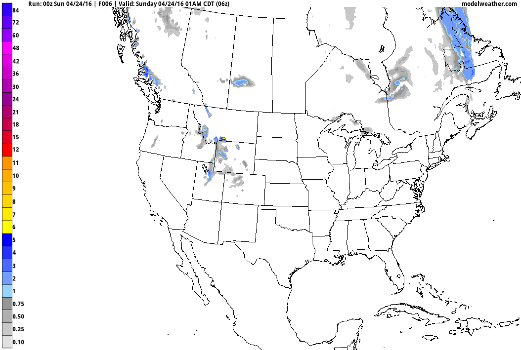
Simulated Radar
Here's
the simulated radar from midday Sunday to Tuesday night. After a very
nice Saturday, Sunday featured widely scattered showers and
thunderstorms, some of which brought heavy rainfall. The same storm
system will still be with us early next week with lingering (colder)
rain showers on Monday. We finally start to see some clearing on
Tuesday, but it will be brief. Rain showers look to return by midweek.
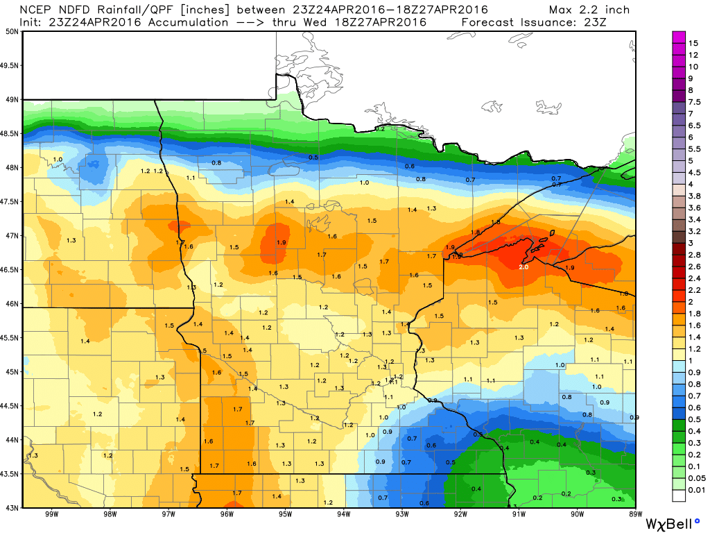
Precipitation Outlook
Here's
the precipitation outlook through midday Wednesday, which suggests some
steadier 1" to nearly 2" tallies across parts of northern Minnesota and
Wisconsin. Some of this rain will be associated with thunderstorm
activity, but much of it will be a steady, soaking rain.
__________________________________________
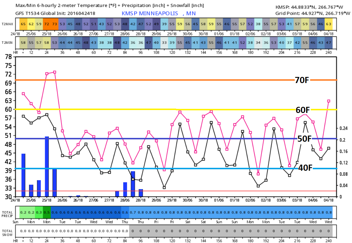
Extended Outlook
Here's
the extended forecast through the end of April/early May, which shows
cooler than average temperatures continuing through much of next week.
We may flirt with 60F a few times, but overall temps will stay below
average.
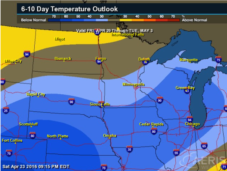
6 to 10 Day Temperature Outlook
According
to NOAA's CPC, the 6 to 10 day temperature outlook suggests a decent
chance of cooler than average temperatures across the Midwest by end of
the month/start of May.
____________________________
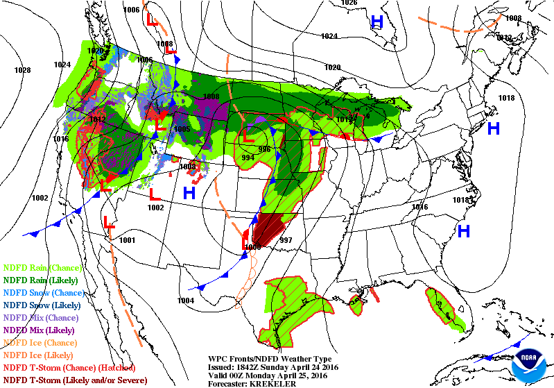
National Weather Outlook
Here's
the weather outlook through PM Tuesday, which shows 2 different systems
moving through the country. The first of which will move quickly east
early week, while the next storm system takes shape in the Central U.S.
by early/mid week. Severe weather concerns will increase significantly
Tuesday and Wednesday.
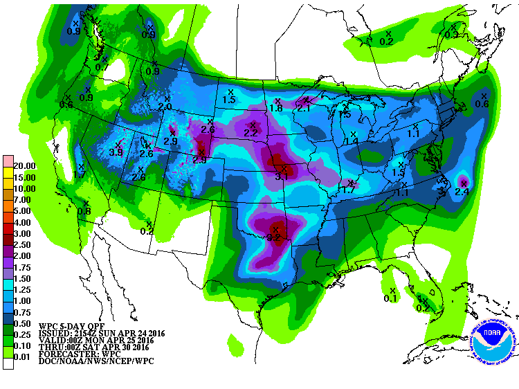
5 Day Precipitation
According
to NOAA's WPC, the 5 day precipitation outlook suggests fairly heavy
rainfall potential across the Central U.S.. Widespread 1" to near 3"
will be possible with several rounds of showers and thunderstorms, some
of which could be severe.
Snowfall Potential?
Here's
the snowfall potential through the end of April according to the GFS
model. Note that most of the accumulations will be found across the
higher elevations in the Western U.S., however, note that it is showing
some minor slushy stuff from parts of the Upper Midwest to the Great
Lakes. While it doesn't appear to be much, it would indicate that
temperatures would be chilly down to below average levels for this to
occur. So next week looks a little chiller than we've seen in recent
days.
___________________________
Upcoming Severe Weather Concerns Next Week
...SUMMARY...
   SIGNIFICANT SEVERE THUNDERSTORMS WILL BE POSSIBLE ACROSS PARTS OF
   THE SOUTHERN AND CENTRAL GREAT PLAINS TUESDAY AFTERNOON INTO THE
   NIGHTTIME HOURS. TORNADOES...SOME STRONG...WILL BE POSSIBLE...IN
   ADDITION TO VERY LARGE HAIL AND DAMAGING WINDS. ADDITIONAL ISOLATED
   STRONG STORMS ARE POSSIBLE ACROSS PARTS OF THE APPALACHIANS TO THE
   DELMARVA DURING THE AFTERNOON.
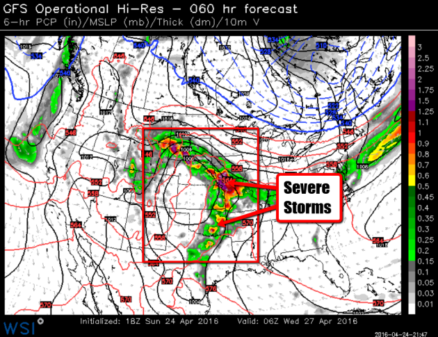
Severe Threat Tuesday, April 26th
...SUMMARY...
   SIGNIFICANT SEVERE THUNDERSTORMS WILL BE POSSIBLE ACROSS PARTS OF
   THE SOUTHERN AND CENTRAL GREAT PLAINS TUESDAY AFTERNOON INTO THE
   NIGHTTIME HOURS. TORNADOES...SOME STRONG...WILL BE POSSIBLE...IN
   ADDITION TO VERY LARGE HAIL AND DAMAGING WINDS. ADDITIONAL ISOLATED
   STRONG STORMS ARE POSSIBLE ACROSS PARTS OF THE APPALACHIANS TO THE
   DELMARVA DURING THE AFTERNOON.
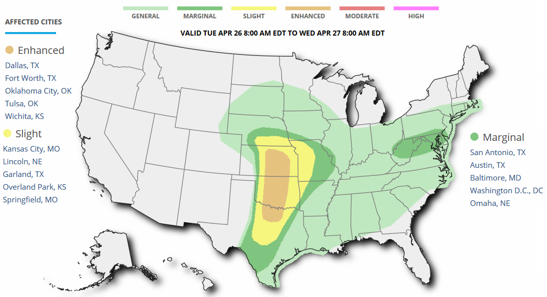
Severe Threat Wednesday, April 27th
...DAY 4/WEDNESDAY...

   A SEVERE THREAT WILL LIKELY SHIFT EASTWARD TOWARD THE MID-MS VALLEY
   INTO AR AND NORTHEAST TX ON WEDNESDAY. THERE IS A BIT OF UNCERTAINTY
   ACROSS MO/IL WHERE ONGOING CONVECTION IS POSSIBLE AT THE BEGINNING
   OF THE PERIOD. FURTHER SOUTH THE AIRMASS WILL LIKELY REMAIN MORE
   PRISTINE WITH RICH BOUNDARY-LAYER MOISTURE IN PLACE BENEATH STEEP
   MIDLEVEL LAPSE RATES...RESULTING IN MODERATE TO STRONG INSTABILITY.
   FORCING FOR ASCENT WILL BE MORE SUBTLE WITH SOUTHWARD EXTENT AS THE
   UPPER TROUGH RESIDES FROM THE CENTRAL PLAINS TO THE MID-MS VALLEY.
   AT LEAST ISOLATED SUPERCELLS ARE EXPECTED ACROSS PARTS OF THE OZARK
   PLATEAU INTO NORTHEAST TX WITH ALL SEVERE HAZARDS POSSIBLE. FURTHER
   NORTH...CONVECTIVE MODE IS MORE UNCERTAIN AND COULD BE RATHER
   MESSY...WITH HAIL AND STRONG WINDS MOST LIKELY.
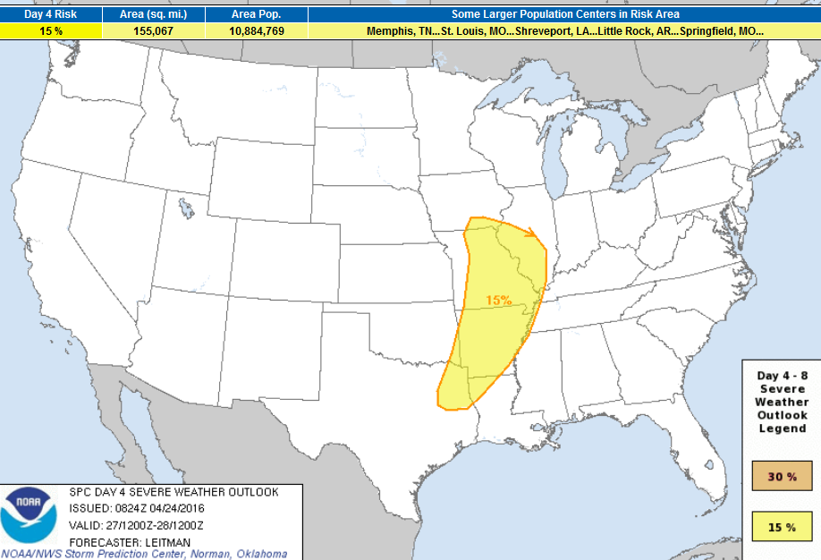
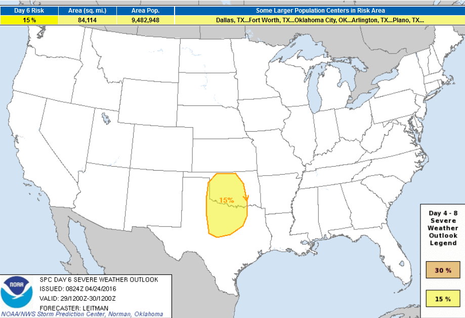
Severe Threat Friday - April 29th
 ...DAY 5/THU - DAY 6/FRI...

   MODELS SHOW QUITE A BIT OF VARIABILITY ACROSS THE CENTRAL AND
   EASTERN U.S. ON DAY 5/THU AS THE UPPER TROUGH OVER THE MID-MS VALLEY
   WEAKENS AND TRACKS EAST ACROSS THE GREAT LAKES TO THE MID-ATLANTIC.
   HOWEVER...AGREEMENT IS FAIRLY GOOD THAT SHORTWAVE RIDGING WILL OCCUR
   OVER THE PLAINS ON THURSDAY...ALLOWING RICH GULF MOISTURE TO ONCE
   AGAIN STREAM NORTHWARD. AS THIS OCCURS...A DYNAMIC...STRONG UPPER
   TROUGH WILL DIG INTO THE SOUTHWESTERN STATES AND SHIFT EASTWARD
   TOWARD THE PLAINS ON DAY 6/FRIDAY. STRONG SOUTHWEST FLOW WILL
   OVERSPREAD THE SOUTHERN/CENTRAL PLAINS ATOP AN INCREASINGLY UNSTABLE
   AIRMASS FRIDAY AFTERNOON. WHILE UNCERTAINTY DOES EXIST IN EXACT
   LOCATION AND TIMING...IT APPEARS ANOTHER ROUND OF STRONG TO SEVERE
   STORMS WILL BE POSSIBLE ACROSS PARTS OF THE SOUTHERN PLAINS ON
   FRIDAY.
_____________________________________________
"Climate Deal Won't Stop Great Barrier Reef From Getting 'Cooked', Say Greens"
"Australia’s lack of follow-through on climate change will leave the Great Barrier Reef “completely cooked” despite it signing the Paris climate deal, the Greens say. The federal environmental minister, Greg Hunt, has joined leaders from 170 other countries in New York to sign the Paris Agreement to limit global warming by at least 2C."See more from TheGaurdian.com HERE:
(Photo Courtesy: Norbert Probst/Alamy via TheGuardian.com)

Thanks for checking in and have a great rest of your week and weekend ahead!
Follow me on Twitter @TNelsonWX
Follow me on Twitter @TNelsonWX

Nice post...I look forward to reading more, and getting a more active part in the talks here, whilst picking up some knowledge as well..
ReplyDeletehumidity chamber manufacturer