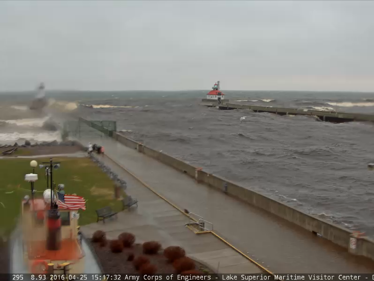
Duluth Waves
The
same storm system responsible for our scattered showers and storms over
the last couple of days was also responsible for strong winds and large
waves on Lake Superior. This was the webcam from Duluth, MN, which
shows large rollers crashing along the piers.
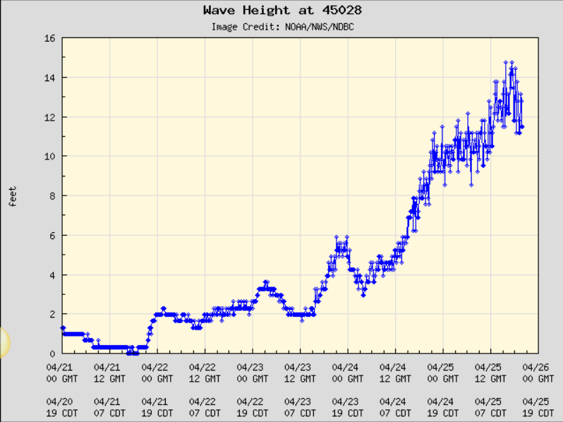
Large Lake Superior Waves
Take
a look at the wave heights recorded by this buoy a few miles offshore
near Duluth, MN. Note that it was recording 10ft to near 15ft waves
during the day Monday!
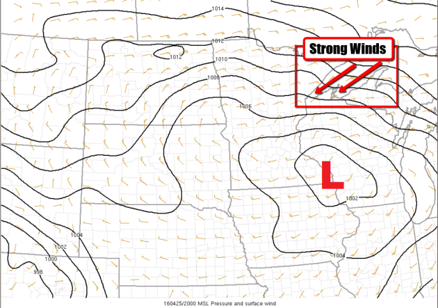
Strong Storm System
This
is a look at the storm on Monday afternoon. Note that the central of
low pressure was located near southeastern Minnesota, however, a tight
pressure gradient and a friction free northeastern wind allowed for a
strong steady fetch to pile up waves in the western tip of the lake.
___________________________________
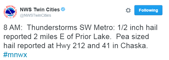
Monday Morning Thunder
The
storm system responsible for our somewhat soggy weather yesterday was
responsible for more thunderstorms Monday. Lightning, thunder, heavy
rainfall and even small hail reports moved in early/mid morning.
______________________________________
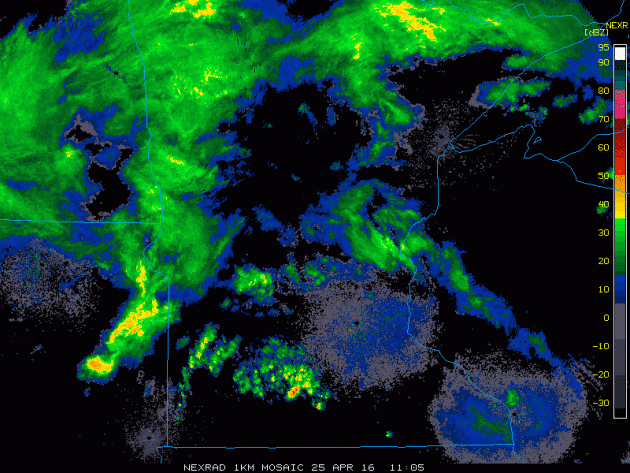
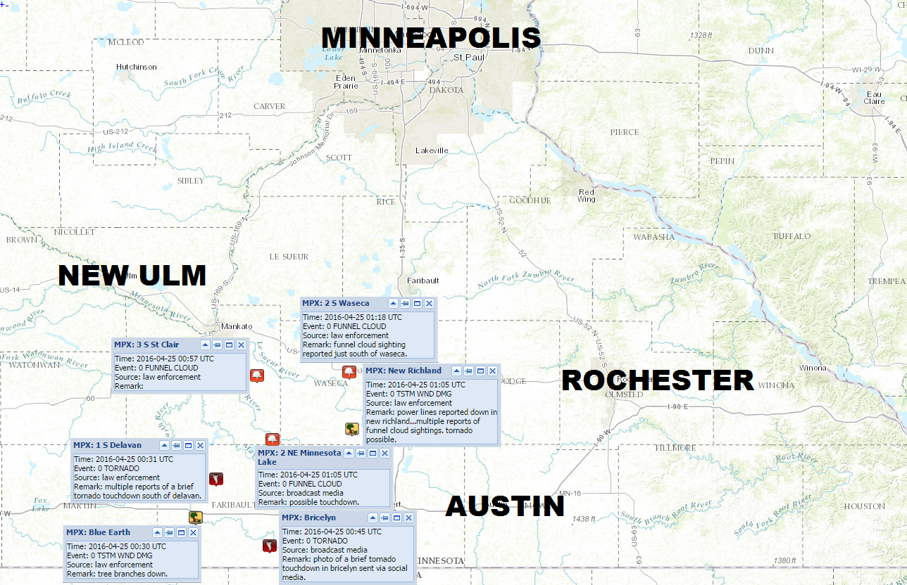
First Minnesota Tornado of 2016
A
line of thunderstorms developed late yesterday afternoon/evening, some
of which became severe across southern MN. In fact, there were multiple
reports of a brief tornado or two in Faribult county. Here are some
images that were being shared via social media last night.
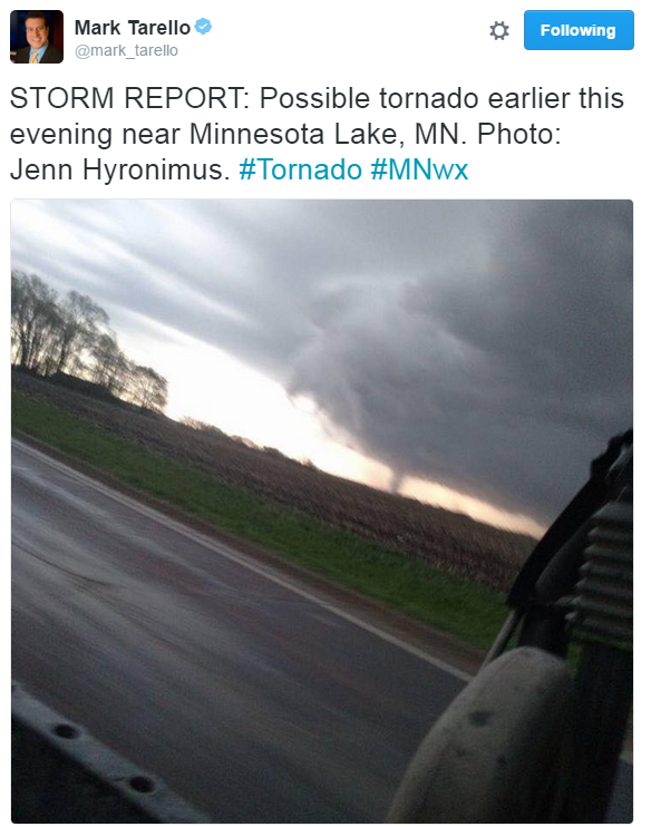
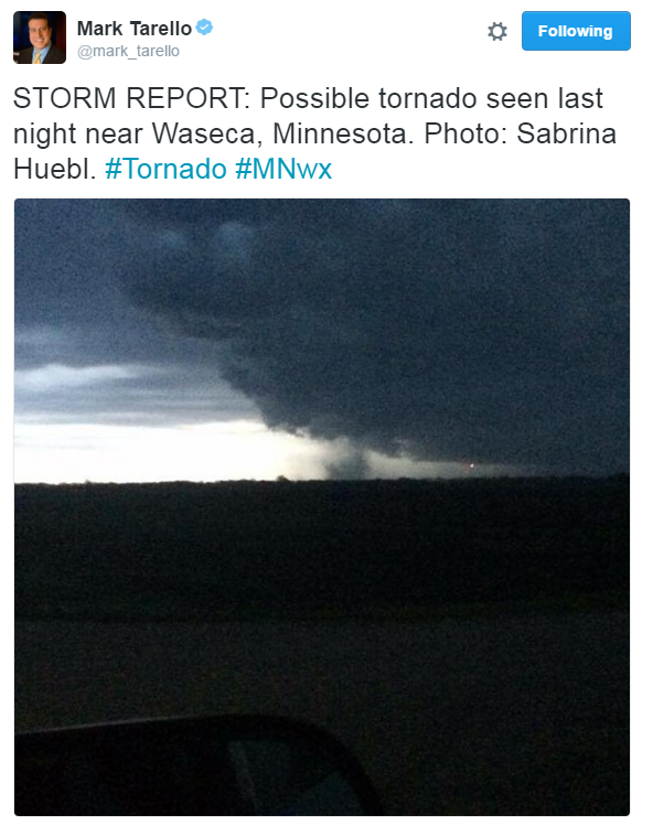
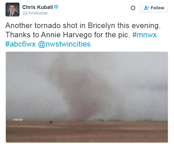
Tornado Reports Sunday Evening
As
it stands now, these are the first Minnesota tornado reports of 2016.
We may know more later today or this week if/when the National Weather
Service out of the Twin Cities releases more information. Stay tuned.
____________________________________
Severe outbreak in the Plains - Cool rain for us
By Todd Nelson, filling in for Douglas.
Today could be a BIG day in the Plains. Weather conditions look ripe for a severe weather outbreak with extremely large hail, damaging winds and long-tracked tornadoes. Interestingly, the Storm Prediction Center out of Norman, OK has had today in its sights and has been warning of this potentially dangerous situation since last week! I have a hunch that today could rival the biggest severe weather day of the year thus far, which hosted nearly 400 severe reports back in February.
Today's severe threat in the Central U.S. is an extension of the the active Pacific flow that will keep on and off rain chances in place for us through the upcoming weekend. Keep in mind that we will be on the northern side of these potent storms, so cool, wind-whipped rain showers will be our main concern.
Looking ahead, temps should remain below average through the end of the month with near 70 degree weather returning by the first week of May. By the way, he average high May 1st is 65 degrees. It warms to 74 by the 31st!
We're getting there.
_____________________
Extended Forecast
MONDAY NIGHT: Lingering clouds. Few showers. Winds: N10. Low: 43
TUESDAY: Stubborn clouds with a few spits. Winds: ENE 10-15. High: 55.
TUESDAY NIGHT: Mostly cloudy, chance of light rain late. Winds: E 15. Low: 40.
WEDNESDAY: Wind-whipped rain showers, heavier south. Winds: E 10-15. High: 52.
THURSDAY: Lingering cool rain showers, less wind. Winds: E 5-10. Wake-up: 38. High: 52
FRIDAY: Brighter and better, warmer temps. Winds: ESE 5-10. Wake-up: 40. High: 60.
SATURDAY: Breezy. Scattered PM showers Winds: ESE 10-15. Wake-up: 45. High: 58.
SUNDAY: Nagging wind, scattered light rain. Winds: ENE 10-15. Wake-up: 44. High: 58.
MONDAY: Below average temps for early May. Winds: NE 10-15. Wake-up: 43. High: 59.
_________________________
_________________________
This Day in Weather History
April 26th
April 26th
1954: Extremely heavy downpours occur in Mora, where nearly 7 inches of rain would fall in a little over 10 hours.
_________________________
_________________________
Average High/Low for Minneapolis
April 26th
April 26th
Average High: 63F (Record: 85F set in 1970)
Average Low: 42F (Record: 26F set in 1950)
__________________________
Average Low: 42F (Record: 26F set in 1950)
__________________________
Sunrise/Sunset Times for Minneapolis
April 26th
April 26th
Sunrise: 6:09am
Sunset: 8:13pm
Sunset: 8:13pm
*Daylight gained since yesterday: ~2mins & 49secs
*Daylight gained since winter solstice: ~5hours & 18mins
______________________________
*Daylight gained since winter solstice: ~5hours & 18mins
______________________________
Moon Phase for April 26th at Midnight
3.9 Days Before Last Quarter
3.9 Days Before Last Quarter
________________________________
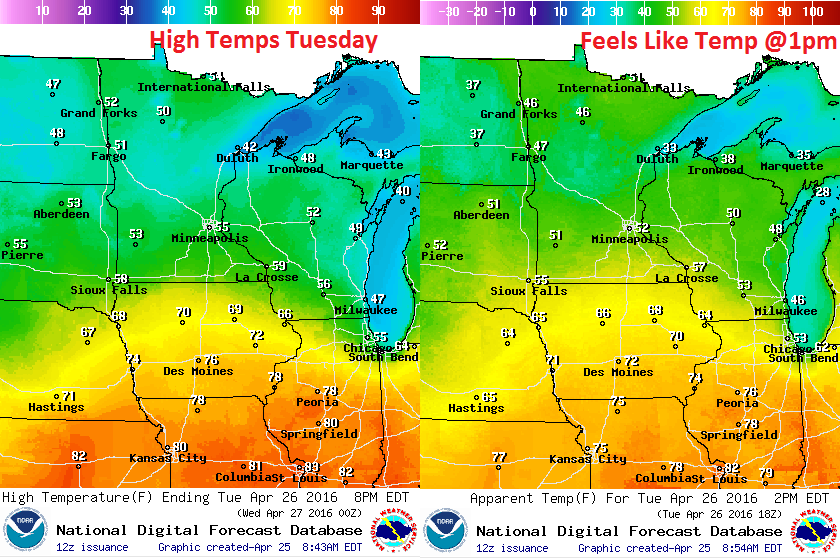
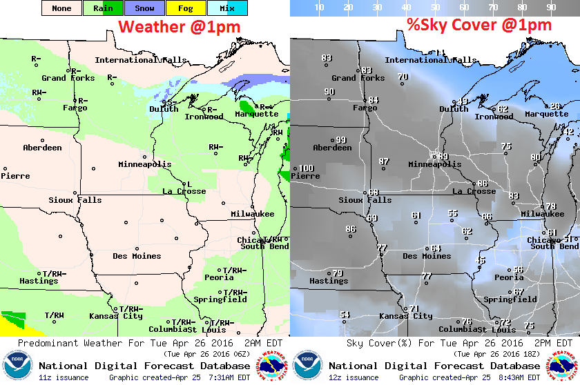
Tuesday Weather Outlook
High
temperatures on Tuesday will be quite cool across the state. Most will
only make it into the 50s, which will be nearly 5F to 10F below average.
Note that the 60s, 70s and even 80s won't be far away!
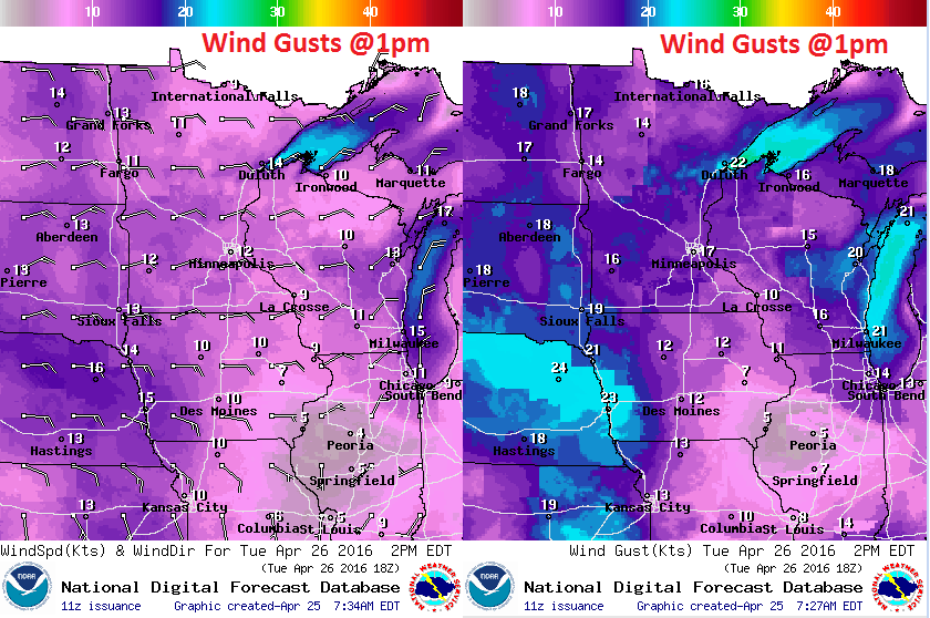
Tuesday Weather Outlook
Winds
will still be out of the east as the next storm system develops and
approaches from the southwest. Winds will certainly be much stronger
closer to Lake Superior just like they were Monday.
Tuesday Weather Outlook
While
most of the heavy rainfall will be done on Tuesday, there may still be a
few spits here and there and cross the central part of the state. Note
that parts of northern Minnesota could see some sunshine by the
afternoon!
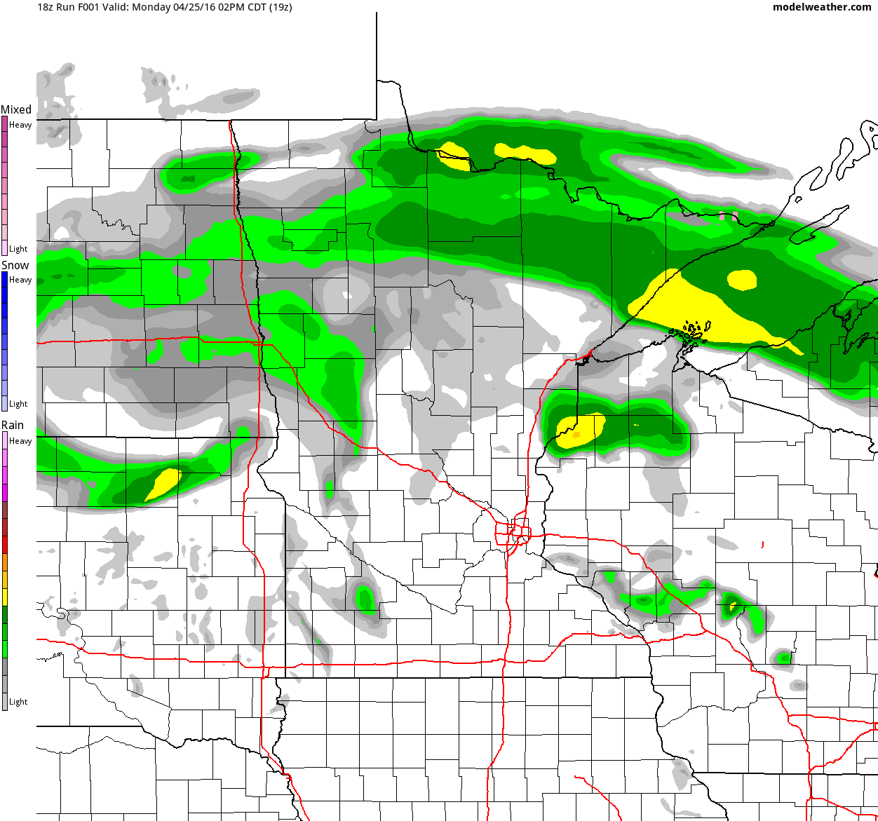
Simulated Radar
Here's
the simulated radar from midday Monday to Wednesday night. Mostly
cloudy skies and a few spits of rain will still be in association with
the same storm system that brought us heavier pockets of rain Sunday and
Monday. It appears that another wave heavier rain will slide through
the region late Tuesday into Wednesday, especially across southern
Minnesota. There may even be a few rumbles of thunder.
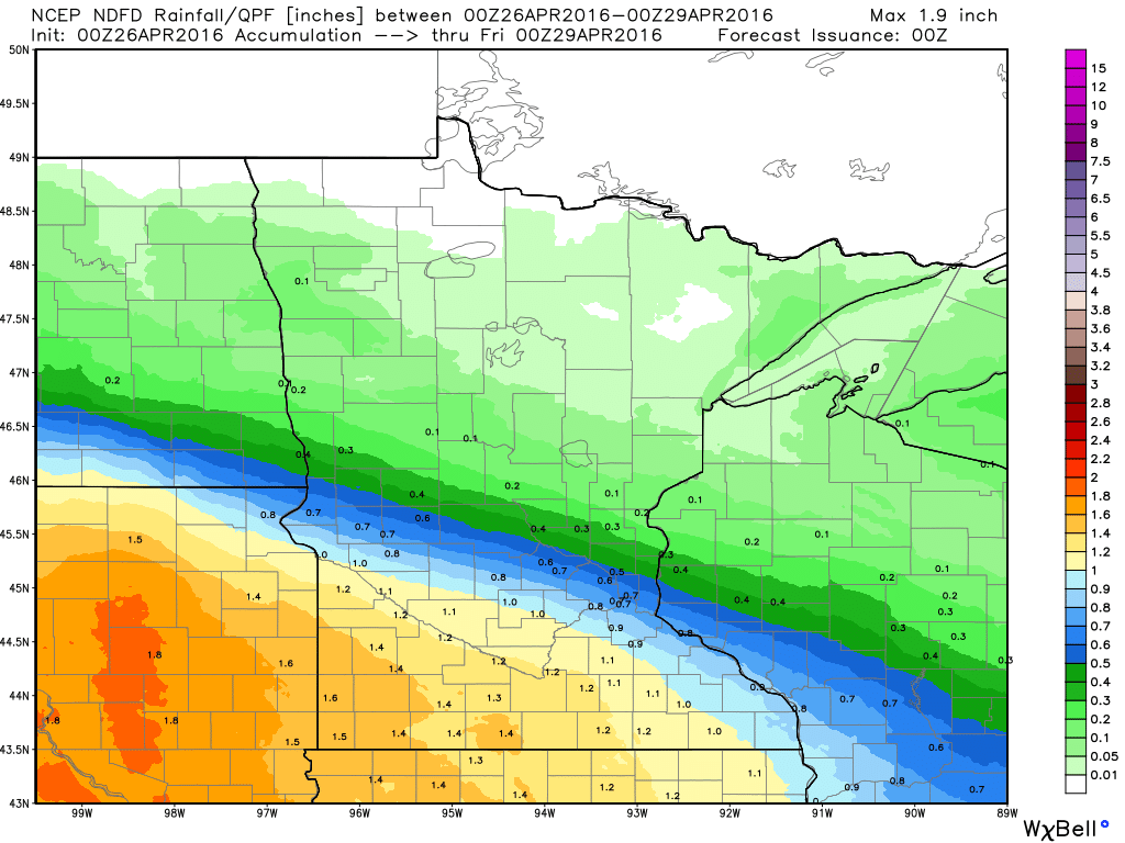
Precipitation Outlook
Here's
the precipitation outlook through 7pm Thursday, which suggests some
steadier 1"+ tallies across parts southern Minnesota. Some of this rain
will be associated with more thunderstorm activity, but much of it will
be a steady, soaking rain late Tuesday into Wednesday as our next storm
system sails through the middle part of the country.
__________________________________________
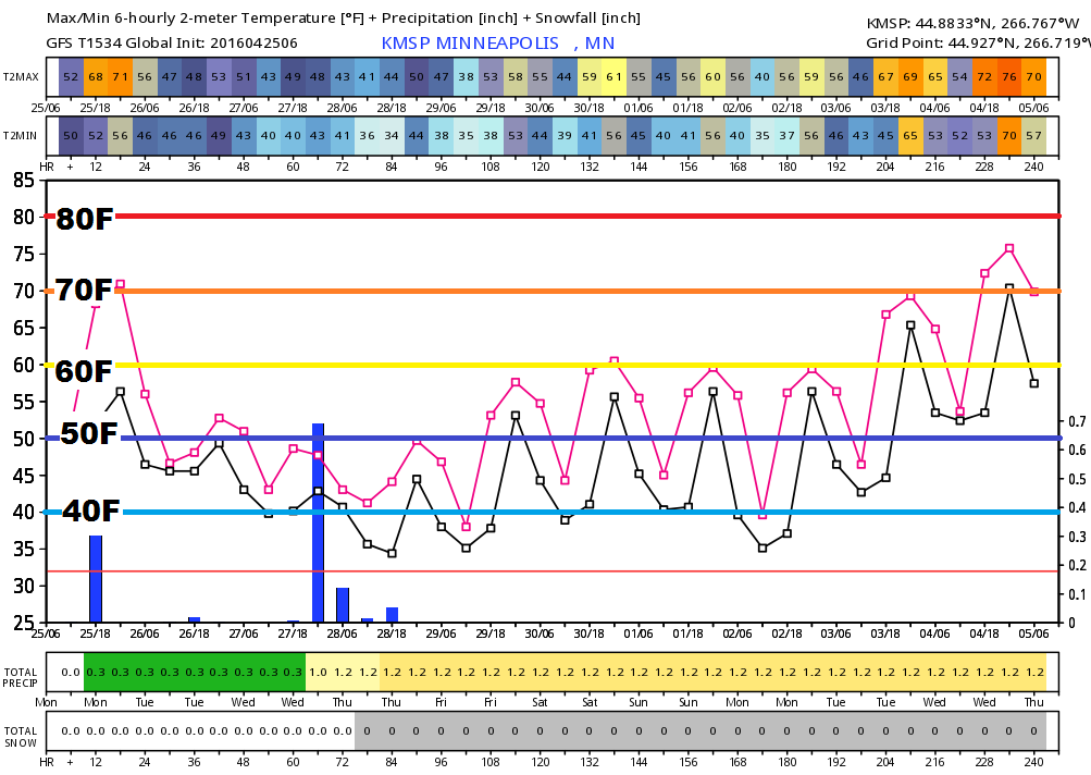
Extended Outlook
Here's
the extended forecast through the end of April/early May, which shows
cooler than average temperatures continuing through much of next week.
We may flirt with 60F a few times, but overall temps will stay below
average until the first week of May.
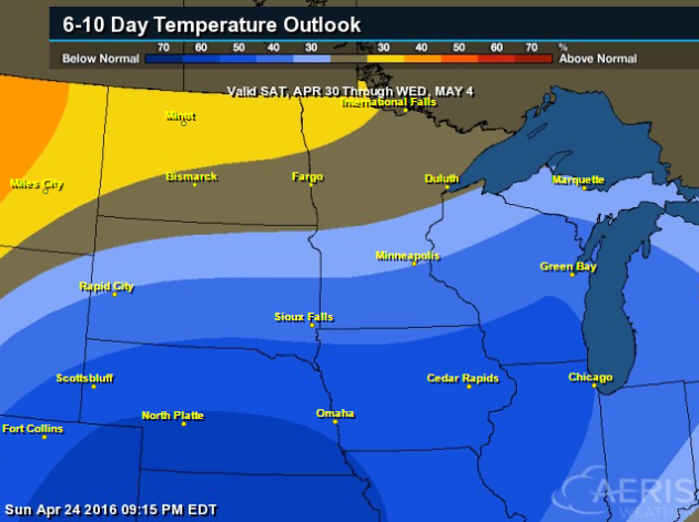
6 to 10 Day Temperature Outlook
According
to NOAA's CPC, the 6 to 10 day temperature outlook suggests a decent
chance of cooler than average temperatures across the Midwest through
the end of the April.
____________________________
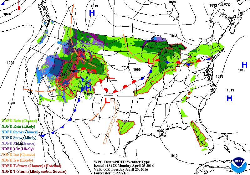
National Weather Outlook
Here's
the weather outlook through PM Wednesday, which shows 2 different
systems moving through the country. The first of which will move quickly
east early week, while the next storm system will continue to take
shape in the Central U.S. through midweek. Severe weather concerns will
increase significantly Tuesday and Wednesday in the middle part of the
country.
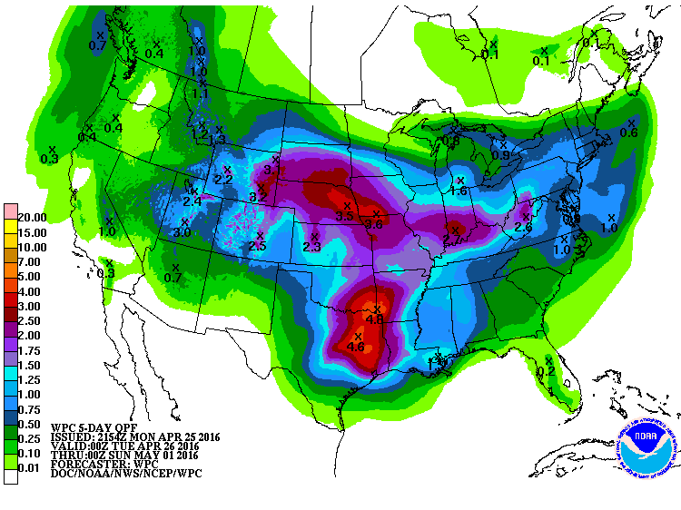
5 Day Precipitation
According
to NOAA's WPC, the 5 day precipitation outlook suggests fairly heavy
rainfall potential across the Central U.S.. Widespread 2" to near 4"+
will be possible with several rounds of showers and thunderstorms, some
of which could be severe.
Snowfall Potential?
Here's
the snowfall potential through the end of April according to the GFS
model. Note that most of the accumulations will be found across the
higher elevations in the Western U.S., however, note that it is showing
some minor slushy stuff from parts of the Upper Midwest to the Great
Lakes. While it doesn't appear to be much, it would indicate that
temperatures would be chilly down to below average levels for this to
occur. So next week looks a little chiller than we've seen in recent
days.
___________________________
Upcoming Severe Weather Concerns Next Week
...SUMMARY...
   SIGNIFICANT SEVERE THUNDERSTORMS WILL BE POSSIBLE ACROSS PARTS OF
   THE SOUTHERN AND CENTRAL GREAT PLAINS TUESDAY AFTERNOON INTO THE
   NIGHTTIME HOURS. TORNADOES...SOME STRONG...WILL BE POSSIBLE...IN
   ADDITION TO VERY LARGE HAIL AND DAMAGING WINDS. ADDITIONAL ISOLATED
   STRONG STORMS ARE POSSIBLE ACROSS PARTS OF THE OHIO VALLEY TO THE
   MIDDLE ATLANTIC COAST REGION.
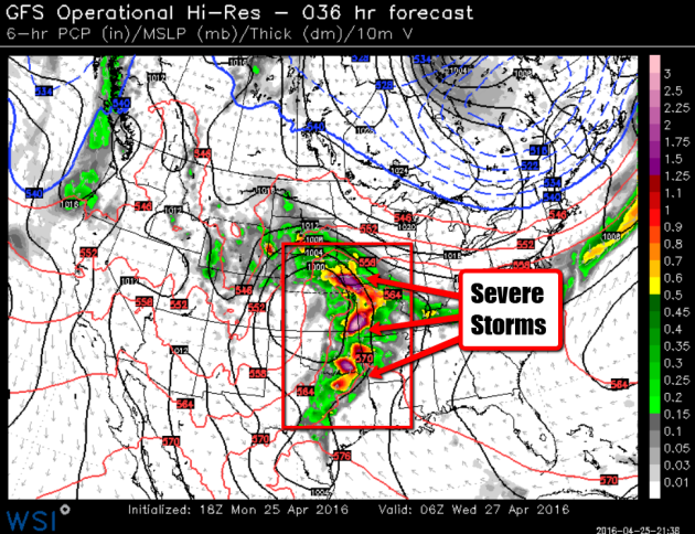
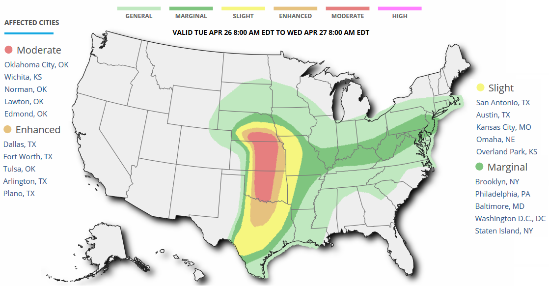
MODERATE Severe Threat - Tuesday, April 26th
...SYNOPSIS...
   DEEP UPPER TROUGH CURRENTLY EXTENDING FROM THE PACIFIC NW INTO THE
   WRN GREAT BASIN WILL CONTINUE EWD THROUGH THE GREAT BASIN TODAY
   BEFORE CONTINUING THROUGH THE FOUR CORNERS AND INTO THE CNTRL PLAINS
   ON TUESDAY. SHORTWAVE TROUGH CURRENTLY ROUNDING THE BASE OF THE
   UPPER TROUGH WILL EJECT NEWD INTO THE CNTRL HIGH PLAINS
   TONIGHT...LEADING TO SURFACE CYCLOGENESIS THIS AFTERNOON AND EVENING
   ACROSS THE HIGH PLAINS. ASSOCIATED STRONG NLY LOW-LEVEL FLOW IS
   EXPECTED TO PERSIST OVERNIGHT...CONTINUING THE POLEWARD TRANSPORT OF
   LOW-LEVEL MOISTURE OVERNIGHT AND INTO TUESDAY. SECOND SHORTWAVE
   TROUGH NOW MOVING THROUGH NRN CA WILL FOLLOW A PATH SIMILAR /BUT
   SLIGHTLY MORE SLY/ TO THE LEAD SHORTWAVE...MOVING THROUGH THE
   SRN/CNTRL HIGH PLAINS TOMORROW AFTERNOON.

   SURFACE CYCLOGENESIS RELATED TO THIS SECOND SHORTWAVE TROUGH IS
   EXPECTED TO RESULT IN A SURFACE LOW ACROSS THE CNTRL HIGH PLAINS BY
   EARLY TUESDAY AFTERNOON. SOME UNCERTAINTY EXISTS ON THE EXACT
   LOCATION OF THIS LOW BUT CURRENT THINKING IS THAT AT 18Z IT WILL BE
   CENTERED OVER NE CO WITH A DRYLINE ARCING FROM THE LOW EWD TO CLOSE
   TO HYS AND THEN SWD TO SPS AND A WARM FRONT EXTENDING EWD FROM THE
   LOW N OF THE KS/NEB THROUGH CNTRL IL.

   PROGRESSION OF THE PREVIOUSLY MENTIONED SHORTWAVE TROUGHS AND THE
   SURFACE FEATURES WILL LIKELY RESULT IN TWO SEPARATE AREAS OF
   NUMEROUS TSTM WITH THE POTENTIAL FOR A RELATIVE MIN IN COVERAGE /BUT
   NOT INTENSITY/ IN BETWEEN /DISCUSSED IN MORE DETAIL BELOW/.
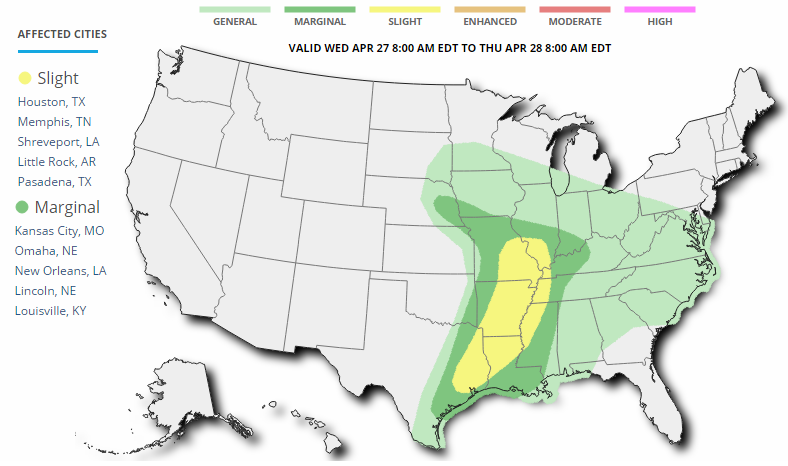
SLIGHT Severe Threat - Wednesday, April 27th
...SUMMARY...
   STRONG TO SEVERE THUNDERSTORMS WILL BE POSSIBLE ON WEDNESDAY FROM
   THE MIDDLE AND LOWER MISSISSIPPI VALLEY INTO EASTERN TEXAS.

   ...MID TO LOWER MS VALLEY AND E TX...

   A COMPLEX AND MESSY FORECAST SCENARIO IS UNFOLDING FOR WEDNESDAY.
   CONVECTION WILL LIKELY BE ONGOING ACROSS PARTS OF MO/IL/AR/TX AS A
   CONTINUATION OF SEVERE STORMS FROM TUESDAY. THIS WILL INCLUDE STRONG
   TO SEVERE LINES AND CLUSTERS NEAR THE WARM FRONT ACROSS MO/IL AND
   POTENTIALLY FURTHER SOUTH ACROSS PARTS OF AR/TX...DEPENDING ON HOW
   THINGS EVOLVE OVERNIGHT ON TUESDAY. AS A RESULT...WHERE GREATER AXIS
   OF INSTABILITY AND AIRMASS RECOVERY COULD DEVELOP IS UNCLEAR. THE
   SLIGHT RISK ENCOMPASSES AREAS WHERE OVERALL JET DYNAMICS AND
   LOW-LEVEL MOISTURE COMBINED WITH STEEP LAPSE RATES COULD SUPPORT
   SEVERE STORMS THROUGH THE AFTERNOON AND EVENING. ALL MANNER OF
   SEVERE HAZARDS WILL BE POSSIBLE GIVEN POTENTIAL ENVIRONMENT
   PARAMETER SPACE...THOUGH THE TORNADO THREAT MAY BE SOMEWHAT LESS
   THAN THE LARGE HAIL/DAMAGING WIND THREAT.

   ...PORTIONS OF SE NEB INTO SW IA AND NORTHWEST MO...

   A CONDITIONAL/LOCALIZED THREAT MAY DEVELOP NEAR THE SURFACE
   LOW/FRONTAL ZONE DURING THE AFTERNOON. THIS IS HIGHLY UNCERTAIN AND
   DEPENDENT ON DEGREE OF DESTABILIZATION. HOWEVER...SOME FORECAST
   SOUNDINGS SHOW A FAVORABLE ENVIRONMENT FOR ISOLATED LARGE HAIL AND
   PERHAPS A TORNADO. OTHER GUIDANCE IS LESS FAVORABLE FOR ANY THREAT
   TO DEVELOP WITH THE WARM FRONT SINKING SOUTHWARD DURING THE MORNING
   HOURS AND BETTER LOW LEVEL FLOW/MOISTURE SHUNTING EAST/SOUTHEAST.
   THIS AREA AND MODEL TRENDS WILL NEED TO BE MONITORED CLOSELY IN THE
   COMING DAYS.
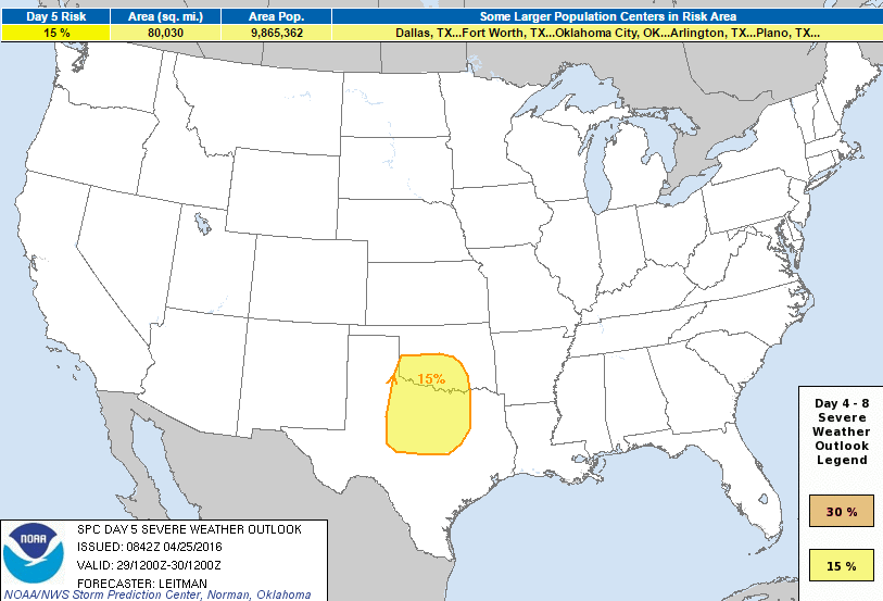
Severe Threat Friday - April 29th
...DISCUSSION...
   ...DAY 4/THU - DAY 5/FRI - PORTIONS OF THE SRN PLAINS...

   AN AREA OF SEVERE STORMS STILL APPEARS PROBABLE ON FRIDAY SOMEWHERE
   ACROSS OK AND/OR TX. EXACT LOCATION WILL DEPEND ON HOW FAR SOUTH THE
   WESTERN U.S. TROUGH DIGS AS IT EJECTS INTO THE PLAINS...AND WHERE
   LEE SURFACE LOW DEVELOPS OVER THE HIGH PLAINS. LOW LEVEL MOISTURE
   WILL STREAM NORTH/NORTHWEST BENEATH SHORTWAVE RIDGING ON
   THURSDAY...WITH RICH BOUNDARY LAYER MOISTURE ACROSS MUCH OF TX INTO
   OK BY FRIDAY. STRONG MIDLEVEL SOUTHWESTERLY FLOW ATOP A SURFACE
   DRYLINE AND BACKED LOW LEVEL WINDS COINCIDING WITH MODERATE
   INSTABILITY SHOULD RESULT IN SEVERE SUPERCELLS ACROSS THE WARM
   SECTOR.
_____________________________________________
Wind Farms' Climate Impacts Recorded For First Time
"In the first study of its kind, scientists have been able to measure the climatic effect of a wind farm on the local environment. The team said its experiment showed that there was a very slight warming at ground level and that it was localised to within a wind farm's perimeter. Data suggested the operation of onshore wind farms did not have an adverse ecological effect, the group added. The findings have been published in the journal Environmental Research Letters. "For a long time there have been some concerns about what effects wind farms could have on the local climate and the land surface," explained co-author Stephen Mobbs, director of the National Centre for Atmospheric Science, based at the University of Leeds. "To be honest, it was mostly speculation with nothing very concrete. We set out to actually measure what was going on.""See more from BBC.com HERE:

________________________________
Thanks for checking in and have a great rest of your week and weekend ahead!
Follow me on Twitter @TNelsonWX
Follow me on Twitter @TNelsonWX

No comments:
Post a Comment