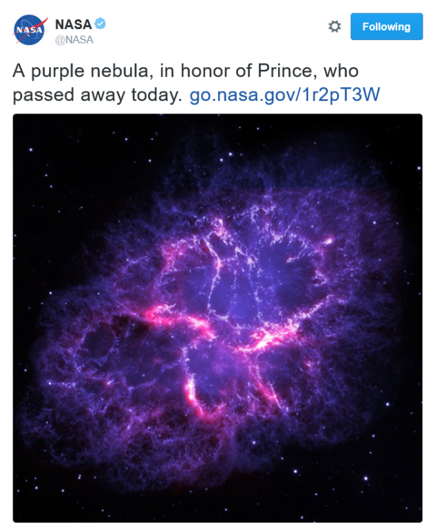
"I never meant to cause you any sorrow
I never meant to cause you any pain
I only wanted to one time to see you laughing
I only wanted to see you
Laughing in the purple rain"
-Prince
(Image courtesy: Getty Images)

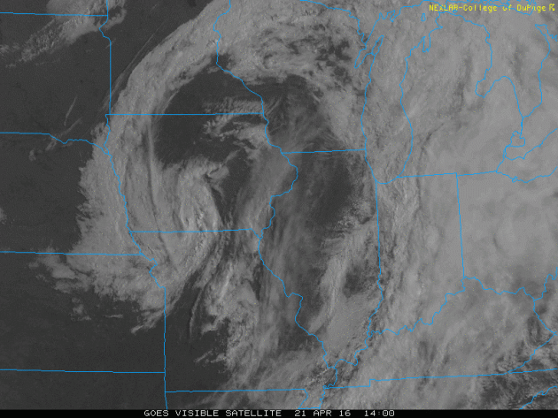
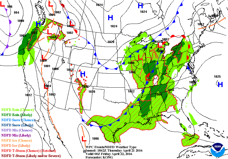
Visible Satellite Thursday
Here's a pretty neat visible satellite loop from Thursday afternoon. You can see the tight counter-clockwise swirl in the atmosphere associated with the slow moving low pressure system that plagued the area for the last few days. Say so long... this storm will no longer be with us on Friday. In fact, Friday looks like a pleasant day with bright sun and temperatures near average.
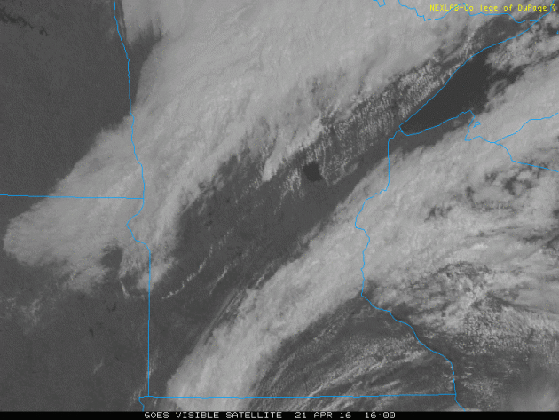
Here
was the visible satellite closer to home as a cold front swept through
the region. This was also responsible for a few heavier downpours and
rumbles of thunder late afternoon/early evening.
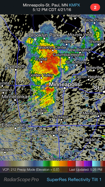
Downpour in Downtown Minneapolis Thursday Evening
One
of the isolated downpours rolled right through downtown Minneapolis
just after 5pm. The good news is that it the storm diminished a little
before it moved through downtown.
_______________________________________
Drier, Brighter Friday - Active Outlook Ahead
By Todd Nelson, filling in for Douglas.
After a few days of cloudy, somewhat soggy weather, the sun will be back in full force today. Grab the shades and revel in all its glory, you deserve it!
Keep in mind that we're only two months away from the summer solstice, which occurs on June 20th this year. We've gained nearly 5 hours of daylight since the winter solstice, how about that!
Interestingly, the sun angle changes from 22 degrees in the winter to an impressive 68 degrees in the summer. With that said, the sun's rays are quite a bit stronger now than they were even just a few week ago. The UV index around midday today is considered high, which means that it will only take about 30 minutes to get a sun burn. Yes it's that time of the year.
Sunny skies today give way to warm and breezy conditions tomorrow. Scattered showers and storms arrive overnight Saturday into Sunday with pockets of heavy rain. Another system arrives early next week with more thunder chances, some possibly severe south of us.
Weather maps look fairly active as we conclude April.
_____________________
Extended Forecast
THURSDAY NIGHT: A few showers early, otherwise clearing. Winds: NNW 10-15. Low: 40
FRIDAY: Bright sun, less wind. Winds: ENE 5. High: 60
FRIDAY NIGHT: Mostly clear. Winds: E 5. Low: 44
SATURDAY: Breezy and warm PM. Storms overnight. Winds: SE 10-15. High: 71.
SUNDAY: Scattered showers and storms. Winds: ENE 10-15. Wake-up: 55. High: 67.
MONDAY: Lingering cold rain. Winds: NNE 10-15. Wake-up: 43. High: 53.
TUESDAY: Brief window of sun returns. Winds: ESE 10-15. Wake-up: 38. High: 56.
WEDNESDAY: Scattered t-storms, some heave? Winds: SE 10-15. Wake-up: 43. High: 60.
THURSDAY: Breezy and cooler. A few stray showers. Winds: WNW 10-15. Wake-up: 46. High: 58
_________________________
This Day in Weather History
April 22nd
1874: Unseasonably cold air moves into Minnesota. The low is 23 degrees at the Twin Cities.
_________________________
Average High/Low for Minneapolis
April 22nd
Average High: 61F (Record: 90F set in 1980)
Average Low: 40F (Record: 23F set in 1874)
__________________________
Sunrise/Sunset Times for Minneapolis
April 22nd
Sunrise: 6:16am
Sunset: 8:08pm
*Daylight gained since yesterday: ~2mins & 54secs
*Daylight gained since winter solstice: ~5hours & 6mins
______________________________
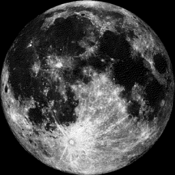
Moon Phase for April 22nd at Midnight
1.1 Days After Full (Pink) Moon
________________________________
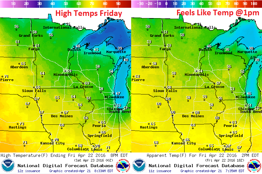
Friday Weather Outlook
High temperatures on Friday will be a little cooler than they were earlier this week, however, we'll be pretty close to average for mid April.
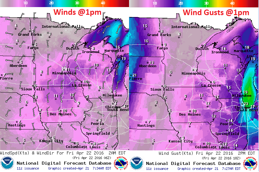
Friday Weather Outlook
The gusty winds that passed behind the cold front will continue to subside through the day Friday. Note that winds across the northern part of the state will be much lighter. Those lighter winds will continue to settle south as we head through the day.
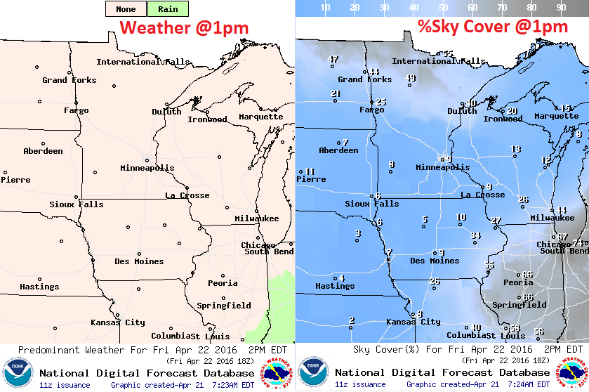
Friday Weather Outlook
No problems! Bright sun and lighter winds will be with us on Friday. It'll be a pretty pleasant end to the work week.
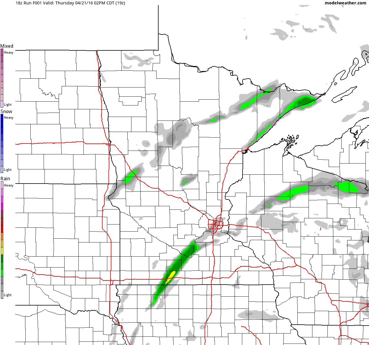
Simulated Radar
The simulated radar from midday Thursday to Saturday night shows soggy weather conditions fading late Thursday to a fairly sublime Friday to a more inclement PM Saturday. Enjoy Friday and early Saturday before the weather sours by the end of the weekend.
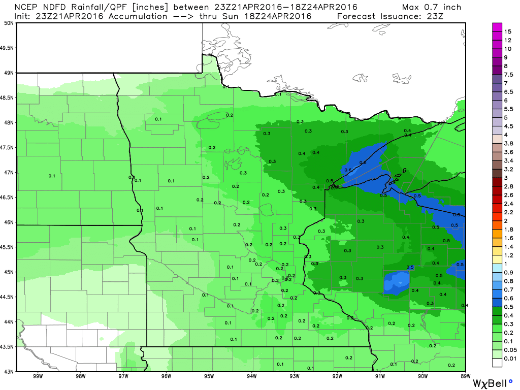
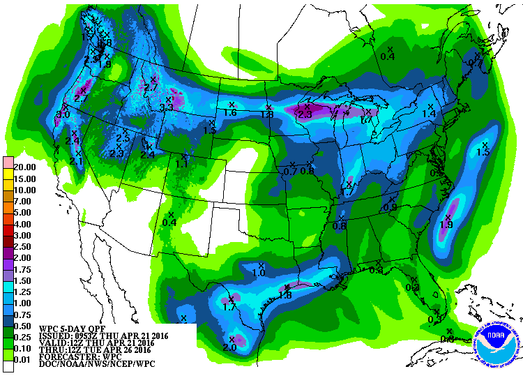
Precipitation Outlook
The precipitation potential through midday Sunday suggests an increasing rainfall potential through the end of the weekend. Some of the rain could be enhanced by spotty thunderstorms, stay tuned.
__________________________________________
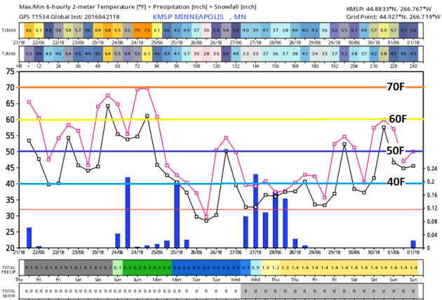
Extended Outlook
The extended forecast suggests temperatures in the 60s to near 70F through the weekend, but the bottom falls out a bit next week. Interestingly, some of the extended forecasts into next week suggest wintry precipitation potential up north next week!
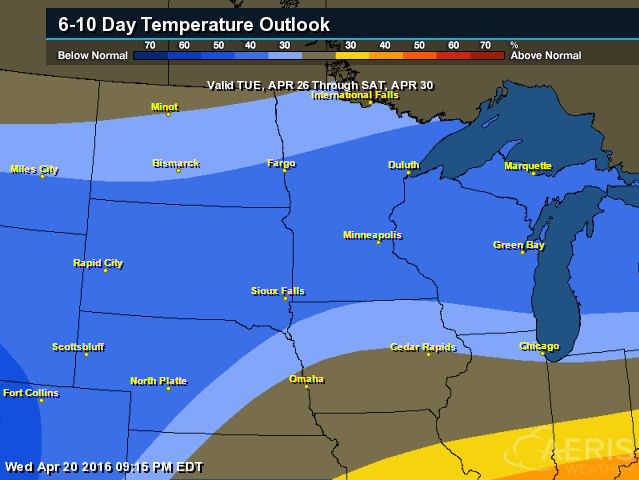
6 to 10 Day Temperature Outlook
According to NOAA's CPC, the 6 to 10 day temperature outlook suggest a fairly decent chance of cooler than average temperatures returning as we head into the last full week of April.
____________________________
National Weather Outlook
Weather conditions look fairly active as we head into the end of the month as Pacific storms work through the country. Here's the weather outlook through the early weekend.
5 Day Precipitation
According to NOAA's WPC, the 5 day precipitation forecast suggests heavier pockets of rain across southern Texas and across the northern tier of the nation. Interestingly, some of this moisture will be wintry fashion.
Snowfall Potential?
As our next storm system moves into the Western U.S., snow will fall across the high elevations there. Interestingly, there are indications that some wintry precip could fall across the northern tier of the nation early next week as well.
___________________________
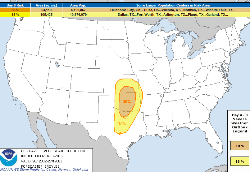
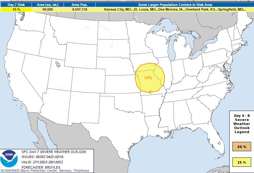
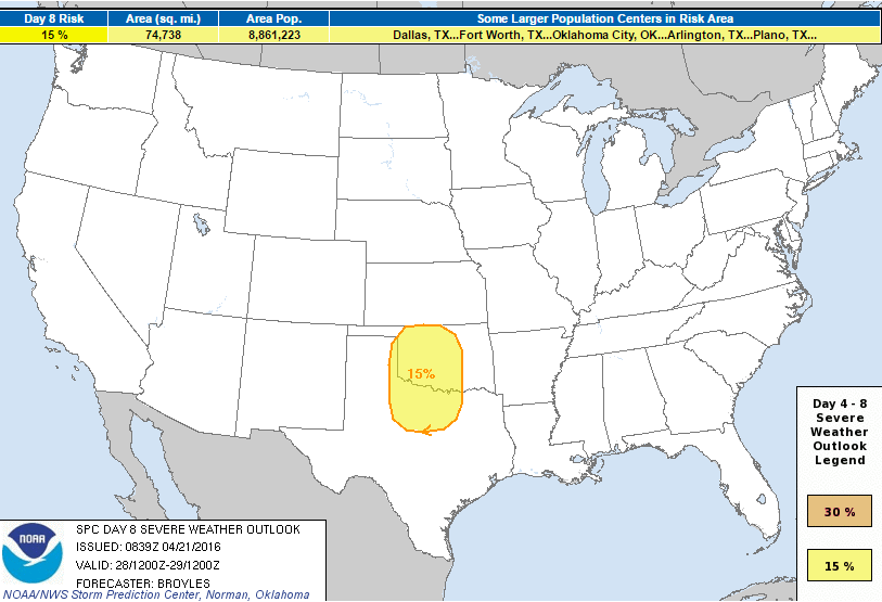
Severe Threat Next Week?
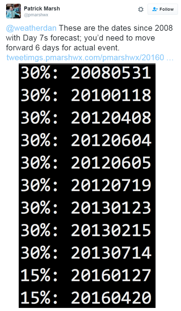
On
Wednesday, April 20th, NOAA's SPC issued a DAY 7 severe threat, for
severe weather concerns next week. Interestingly, this is only the 12th
time since 2008 that a DAY 7 has been issued, which means the confidence
is pretty decent that strong/severe storms may develop next week.
Interestingly, the update from NOAA's SPC on Thursday, April 21st had
ANOTHER DAY 7 severe threat (only the 12th time issued since 2008) and
remarkably now, a DAY 8 severe threat. According to @pmarshwx at the
Storm Prediction Center, there have only been 2 issuance of a DAY 8
since 2008!
...DISCUSSION...
   THE MEDIUM RANGE MODELS BEGIN THE DAY 4 TO 8 PERIOD WITH AN
   UPPER-LEVEL TROUGH IN THE CNTRL ROCKIES AND MOVE THIS FEATURE EWD
   INTO THE GREAT PLAINS ON SUNDAY/DAY 4. AHEAD OF THE UPPER-LEVEL
   TROUGH...AN ISOLATED SEVERE THREAT MAY DEVELOP SUNDAY AFTERNOON
   ALONG AN AXIS OF INSTABILITY EXTENDING NNEWD FROM THE SRN PLAINS
   INTO THE MID MO VALLEY. ON MONDAY/DAY 5...THE MODELS BRING A
   SHORTWAVE RIDGE NEWD ACROSS THE CNTRL PLAINS AND MAINTAIN AN AXIS OF
   INSTABILITY IN THE SRN PLAINS WHERE AN ISOLATED SEVERE THREAT WILL
   AGAIN BE POSSIBLE. ON TUESDAY/DAY 6...THE ECMWF AND GFS CONTINUE TO
   MOVE A NEGATIVELY-TILTED UPPER-LEVEL TROUGH AND ASSOCIATED MID-LEVEL
   JET ENEWD ACROSS THE SRN ROCKIES AND INTO THE SRN PLAINS. THE MODELS
   SHOW A WELL-DEVELOPED DRYLINE ACROSS THE SRN AND CNTRL PLAINS
   TUESDAY AFTERNOON. TO THE EAST OF THE DRYLINE...SFC DEWPOINTS IN THE
   MID TO UPPER 60S F AND STRONG DESTABILIZATION SHOULD BE FAVORABLE
   FOR SUPERCELLS. AS THE EXIT REGION OF THE MID-LEVEL JET OVERSPREADS
   A VERY MOIST AND UNSTABLE AIRMASS...A SEVERE WEATHER OUTBREAK WILL
   BE POSSIBLE WITH TORNADOES...LARGE HAIL AND WIND DAMAGE TUESDAY
   AFTERNOON AND EVENING. THE MODELS HAVE BEEN CONSISTENT ENOUGH TO
   WARRANT ADDING A 30 PERCENT CONTOUR ACROSS PARTS OF NORTH TX...OK
   AND SRN KS. ON WEDNESDAY/DAY 7...THE MODELS ARE IN REASONABLE
   AGREEMENT MOVING THE UPPER-LEVEL TROUGH INTO THE MO VALLEY AND
   HAVING AN AXIS OF INSTABILITY IN THE MID MS VALLEY EXTENDING SWWD
   INTO THE SRN PLAINS. SEVERE THUNDERSTORMS MAY OCCUR ALONG PARTS OF
   THIS CORRIDOR WEDNESDAY AFTERNOON AND EVENING WHERE A SIGNIFICANT
   SEVERE WEATHER EVENT WILL BE POSSIBLE. ON THURSDAY/DAY 8...ANOTHER
   UPPER-LEVEL TROUGH IS FORECAST TO DEVELOP IN THE SWRN U.S. WITH
   SOUTHWEST FLOW IN PLACE IN THE SRN PLAINS WHERE SEVERE THUNDERSTORMS
   WILL AGAIN BE POSSIBLE THURSDAY AFTERNOON AND EVENING.
Severe Threat Tuesday, April 26th - DAY 6
Severe Threat Wednesday, April 27th - DAY 7
Severe Threat Thursday, April 28th - DAY 8
__________________________________
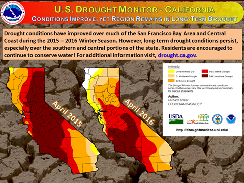
Update on California Drought
Here's an update on the drought situation in California from the National Weather Service out of San Francisco, CA
"The latest U.S. Drought Monitor shows improvements in the drought conditions across portions of the state as a result of rainfall during the 2015 - 2016 Winter Season. However, El Niño conditions did not provide the central and southern portion of the state with above average rainfall that so many expected. Thus, with conditions favorable for La Niña to emerge within 6 months, water conservation remains critical. For more information on the California drought, visit drought.ca.gov and climate.gov/enso for additional details on El Niño/La Niña."
See more HERE:
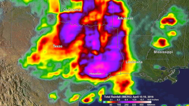
"NASA's GPM Looks at Texas Heavy Rainfall"
"A slow-moving frontal system associated with a stagnant upper-air pattern set the stage for heavy rains and flooding early this week from East Texas all the way up through the Central and Northern Plains. NASA estimated the heavy rainfall using satellite data that showed the hardest hit region was in and around the Houston area."
See more from NASA HERE:
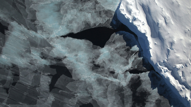
"Antarctica’s Melting Ice Sheets Could Slow Climate Change"
"Climate change is making the Antarctic blue—and that might be good news for the rest of the planet. Seafloor communities are flourishing beneath newly ice-free Antarctic seas, and as they grow, they are turning into carbon sinks, gobbling up carbon that might otherwise end up in the atmosphere. “The big deal about this study is not really that Antarctica has a carbon sink—anyone who walks out into a forest sees a carbon sink,” said author David Barnes, of the British Antarctic Survey, who published his work in the September 21 issue of Current Biology. “Yet most carbon sinks don’t get bigger as climate change gets more severe. This one gets bigger.”
See more from PBS HERE:
Thanks for checking in and have a great rest of your week and weekend ahead!
Follow me on Twitter @TNelsonWX

No comments:
Post a Comment