Tropical Cyclone Amos
While
things are quite in the tropics close to home, it's a little more
active elsewhere. Here's a look a Tropical Cyclone Amost in the South
Pacific Ocean with winds up to 90mph.
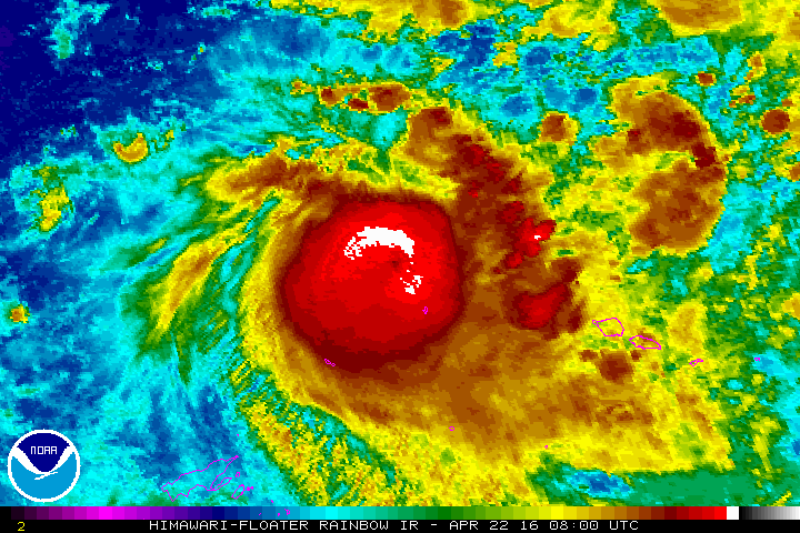
Tropical Storm Fantala
And here is Tropical Cyclone Fantala in the Southern Indian Ocean. Earlier this week, Fantala had winds greater than 100mph.

East Coast should expect active hurricane season, researchers say
"The
2016 Atlantic hurricane season will be significantly more active than
the overall averages from 1950 to the present, according to researchers
at North Carolina State University. The
2016 season should see 15 to 18 tropical storms and hurricanes forming
in the Atlantic basin, which includes the entire Atlantic Ocean, the
Gulf of Mexico and the Caribbean Sea, according to Lian Xie, professor
of marine, earth and atmospheric sciences at NC State. This number is
significantly higher than the 1950 to 2014 average of approximately 11
named storms. Of those named
storms, eight to 11 may grow strong enough to become hurricanes, with
the possibility of three to five storms becoming major hurricanes. This
year's numbers for the Gulf are more in line with historic averages:
Xie's data indicate the likelihood of two to five named storms forming,
with one to three of the storms becoming a hurricane."
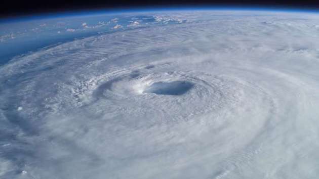
(Hurricane Isabel seen from the International Space Station)
______________________________________
Warm with weekend rumbles - Colder rain next week
By Todd Nelson, filling in for Douglas.
By Todd Nelson, filling in for Douglas.
I am reminded by the lyrics of one of Minnesota's own, Prince, today; "Springtime was always my favorite time of year." He sang this in his song "Sometimes it snows in April."
The recent news hits home. A global icon. A true artist. Now, spring may remind some of us of tears. "All good things, they say, never last." You are gone, but not forgotten.
Weather conditions look quite active into early May as a series of potent Pacific storms move across
the country. Severe weather season is just getting started and next week could feature a decent severe weather outbreak across the Plains.
Keep in mind that May is the busiest month for tornadoes nationwide, averaging 276 from 1991- 2010. Minnesota's busiest month for tornadoes typically peaks in June, averaging 18.
Our first chance of thunder, rumbles in late weekend with more next week. Interestingly, temperatures may be cool enough as these storms depart for wintry precipitation to mix in across parts of the state, especially next week.
Yes, sometimes is does snow in April.
_____________________
_____________________
Extended Forecast
FRIDAY NIGHT: Mostly clear. Winds: E 5. Low: 42
SATURDAY: Sunny start. Mild and turning breezy late. Winds: SE 10-15. High: 71.
SATURDAY NIGHT: Mostly cloudy. Chance of thunder overnight. Winds: SE 10-15. Low: 55
SUNDAY: Breezy. Scattered showers and storms. Winds: ESE 10-15. High: 68.
MONDAY: Cloudy. Lingering colder rain showers and a few rumbles. Winds: NE 10-15. Wake-up: 45. High: 52.
TUESDAY: Clearing. Cool breeze. Winds: E 10-15. Wake-up: 35. High: 55.
WEDNESDAY: Breezy with cold rain. Wintry mix up north? Winds: ENE 10-15. Wake-up: 40. High: 50.
THURSDAY: Cool. Lingering clouds and showers. Winds: ENE 5-10. Wake-up: 39. High: 52
FRIDAY: Dry start. Late day showers. Winds: ESE 10-15. Wake-up: 39. High: 57.
_________________________
_________________________
This Day in Weather History
April 23rd
April 23rd
1990: A record high of 88 degrees is set at Redwood Falls.
_________________________
_________________________
Average High/Low for Minneapolis
April 23rd
April 23rd
Average High: 62F (Record: 86F set in 1990)
Average Low: 41F (Record: 19F set in 1910)
__________________________
Average Low: 41F (Record: 19F set in 1910)
__________________________
Sunrise/Sunset Times for Minneapolis
April 23rd
April 23rd
Sunrise: 6:14am
Sunset: 8:09pm
Sunset: 8:09pm
*Daylight gained since yesterday: ~2mins & 53secs
*Daylight gained since winter solstice: ~5hours & 9mins
______________________________
*Daylight gained since winter solstice: ~5hours & 9mins
______________________________
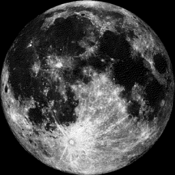
Moon Phase for April 23rd at Midnight
2.1 Days After Full (Pink) Moon
2.1 Days After Full (Pink) Moon
________________________________
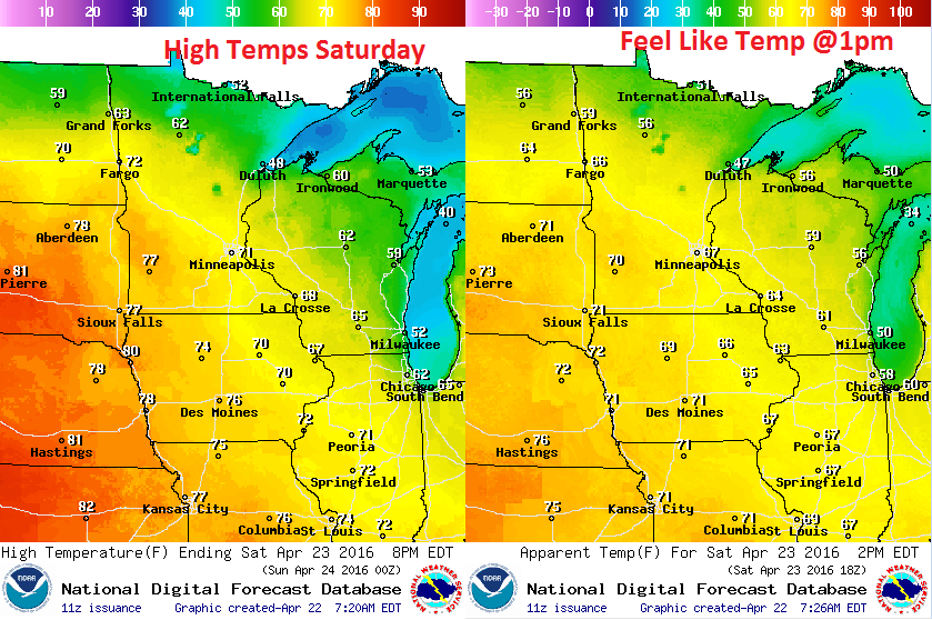
Saturday Weather Outlook
Saturday
will be quite warm across the region with high temperatures warming
into the 70s across the southern two-thirds of the state. The warming
will be come by way of a storm system pushing through the region, which
will bring us shower and thunderstorm chances during the second half of
the weekend.
Saturday Weather Outlook
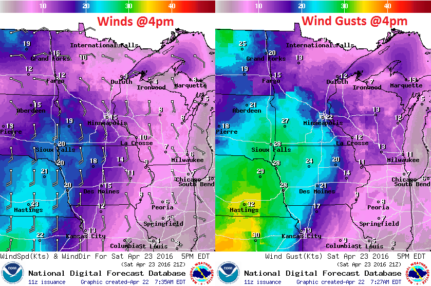
Winds
won't be too bad early Saturday, but as a storm system approaches from
the west, wind speeds will pick up through the day with gusts in the
southwestern part of the state approaching 30mph by the afternoon.
Saturday Weather Outlook
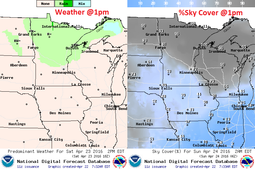
After
a dry start across much of the state, cloud cover will be on the
increase as our storm system approaches. It appears that a few rains
showers could also develop farther north and become a little more
widespread by the evening hours. Spotty thunder can't be ruled out
overnight Saturday into Sunday.
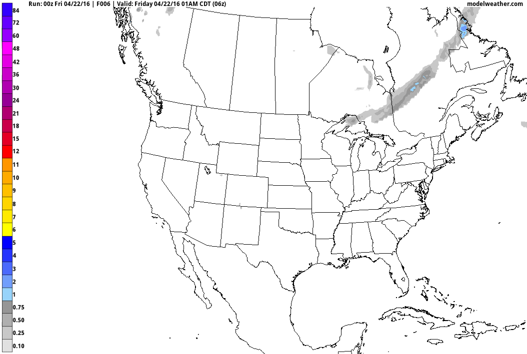
Simulated Radar
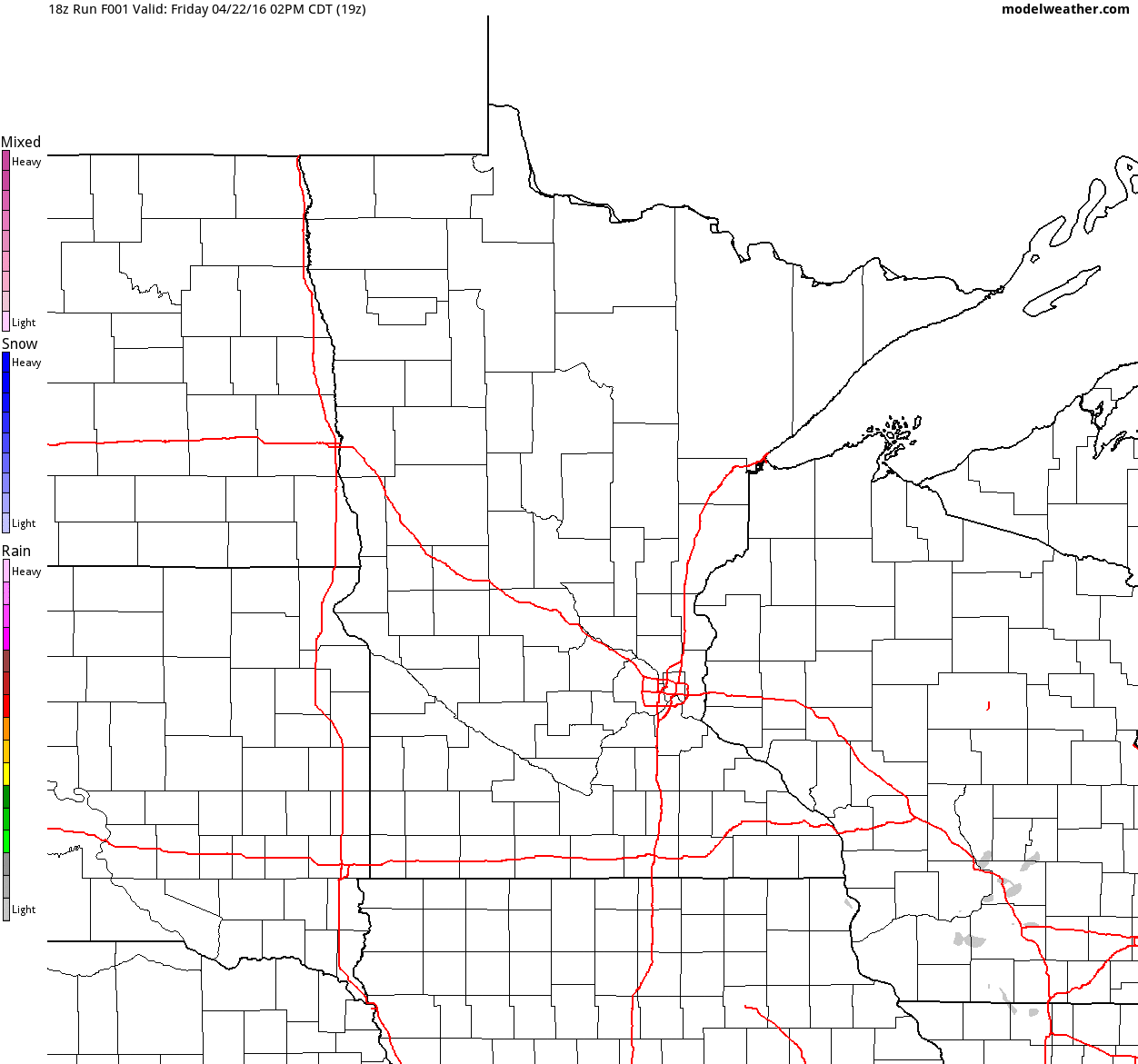
Here's
the simulated radar from Friday morning to Sunday evening. Note that
the weekend looks to start off dry, but we should end on a fairly
unsettled note with scattered showers and storms developing later
Sunday.
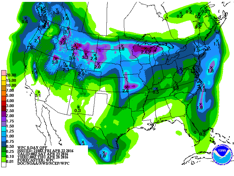
Precipitation Outlook
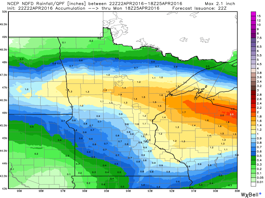
Here's
the precipitation outlook through midday Monday, which suggests some
1"+ tallies across parts of northern Minnesota and Wisconsin. Some of
this rain will be associated with thunderstorm activity.
__________________________________________
Extended Outlook
The
extended forecast through the end of April shows warmer temperatures
this weekend before we see a bit of a dip next week. Highs next week
look to be in the 50s, perhaps even into the 40s across northern
Minnesota. Interestingly, we're getting indications that some of the
moisture that falls next week could fall in a wintry mixed fashion.
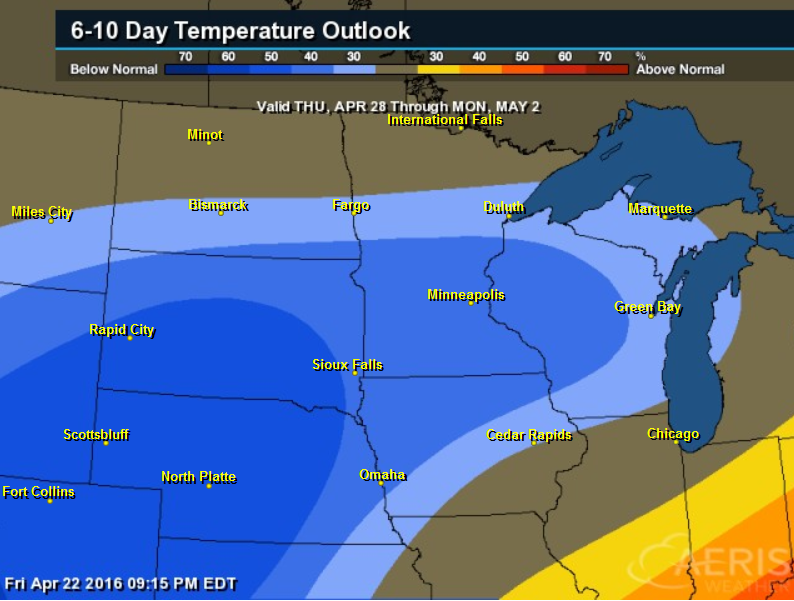
6 to 10 Day Temperature Outlook
According
to NOAA's CPC, the 6 to 10 day temperature outlook suggests a decent
chance of cooler than average temperatures in place by the end of the
month/start of May.
____________________________
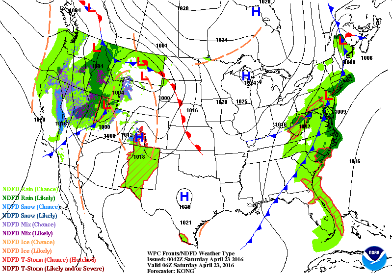
National Weather Outlook
The
national weather outlook through the end of the weekend shows our next
storm system sliding into the Midwest with a fairly substantial amount
of liquid. Keep in mind that not only does our weather look active late
weekend, but it looks unsettled next week too!
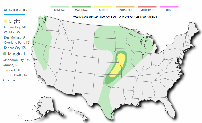
Severe Threat Sunday
...SUMMARY...
   STRONG TO SEVERE THUNDERSTORMS ARE POSSIBLE SUNDAY AFTERNOON AND
   EVENING ACROSS PARTS OF OKLAHOMA AND EASTERN KANSAS INTO THE MIDDLE
   MISSOURI VALLEY.

   ...PORTIONS OF THE SRN PLAINS TO MID-MO VALLEY...

   THE UPPER LOW OVER THE CENTRAL ROCKIES/HIGH PLAINS EARLY SUNDAY
   MORNING WILL SHIFT EASTWARD ACROSS THE CENTRAL PLAINS TOWARD THE
   MID-MO VALLEY BY 12Z MON. AS THE 50+ KT MIDLEVEL JET OVERSPREADS
   OK/KS INTO MO/IA/NEB...SOUTHERLY LOW-LEVEL FLOW WILL TRANSPORT UPPER
   50S TO LOW 60S DEWPOINTS NORTHWARD IN A NARROW CORRIDOR AHEAD OF A
   DRYLINE. ISOLATED TO WIDELY SCATTERED THUNDERSTORMS ARE EXPECTED TO
   DEVELOP IN WEAK CONVERGENCE ALONG THE DRYLINE FROM NORTH-CENTRAL OK
   NORTH/NORTHEAST INTO SOUTHWEST IA. STEEP LAPSE RATES WILL BE IN
   PLACE AND SHEAR PROFILES WILL FAVOR SUPERCELLS WITH THE MAIN CONCERN
   BEING LARGE HAIL. THE THREAT FURTHER SOUTHWEST INTO WESTERN/CENTRAL
   OK APPEARS MORE CONDITIONAL DUE TO CAPPING CONCERNS. SHOULD A STORM
   DEVELOP HOWEVER...LARGE HAIL AND STRONG WINDS WILL BE POSSIBLE.

   ADDITIONAL THUNDERSTORMS ARE POSSIBLE NEAR THE WARM FRONT ACROSS
   PARTS OF EASTERN SD INTO NORTHERN IA AND SOUTHERN MN.
   HOWEVER...MODEL VARIABILITY WITH REGARDS TO MOISTURE AND WEAKER
   LOW/MID-LEVEL FLOW WILL PRECLUDE ADDITION OF PROBS AT THIS TIME.
5 Day Precipitation
According
to NOAA's WPC, the 5 day precipitation forecast suggests heavier
moisture along the northern tier of the nation as weather conditions
become active through the end of the month.
Snowfall Potential?
Snowfall
potential looks more impressive in the high elevations over the Western
U.S.,. Also note the snowfall across the Midwest through next week.
___________________________
Upcoming Severe Weather Concerns Next Week
 ...DISCUSSION...
   A MORE ACTIVE SPRINGTIME SEVERE WEATHER PATTERN IS EXPECTED TO
   DEVELOP NEXT WEEK AND SEVERAL ROUNDS OF STRONG TO SEVERE
   THUNDERSTORMS WILL BE POSSIBLE DURING THE DAY 4-8 PERIOD.
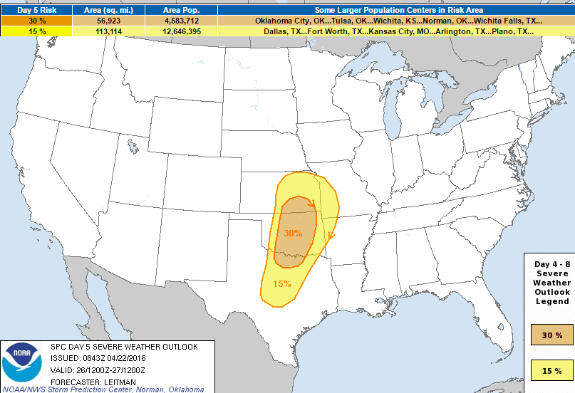
Severe Threat Tuesday, April 26th
...DAY 5/TUESDAY...

   THE GREATEST THREAT FOR SEVERE WEATHER APPEARS TO BE ON DAY 5/TUE.
   DETERMINISTIC AND ENSEMBLE GUIDANCE CONTINUES TO BE IN GOOD
   AGREEMENT...INDICATING INGREDIENTS IN PLACE FOR A POTENTIAL SEVERE
   WEATHER OUTBREAK ACROSS PORTIONS OF THE SRN/CNTRL PLAINS TUESDAY
   AFTERNOON/EVENING. A STRONG UPPER TROUGH OVER THE WESTERN STATES
   WILL BECOME NEGATIVELY TILTED WHILE PIVOTING EASTWARD TOWARD THE
   PLAINS. A 60+ KT MIDLEVEL JET WILL OVERSPREAD NM INTO WRN TX/OK AND
   KS BY TUESDAY AFTERNOON. AT THE SURFACE...A LEE CYCLONE WILL DEVELOP
   OVER ERN CO AND SHIFT EWD ACROSS KS. A SHARP DRYLINE WILL EXTEND
   SOUTH/SOUTHWEST FROM THE LOW OVER SOUTHWEST KS INTO WRN OK AND
   W-CNTRL TX. A WARM FRONT WILL BE DRAPED ACROSS NRN KS INTO THE
   MID-MS VALLEY. SOUTH/SOUTHEASTERLY LOW LEVEL FLOW WILL TRANSPORT MID
   60S TO NEAR 70 DEWPOINTS NORTHWARD ACROSS THE WARM SECTOR...WITH
   MODERATE INSTABILITY IN PLACE BY AFTERNOON. STEEP MIDLEVEL LAPSE
   RATES AND STRONG...VERTICALLY VEERING SHEAR PROFILES WILL FAVOR
   SUPERCELLS CAPABLE OF ALL SEVERE HAZARDS INCLUDING VERY LARGE HAIL
   AND TORNADOES.
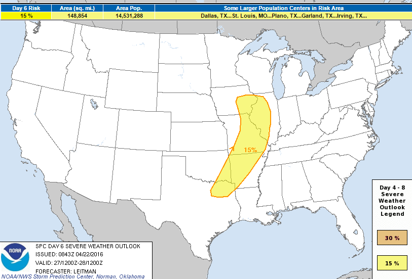
Severe Threat Wednesday, April 27th
...DAY 6/WEDNESDAY...

   THE SEVERE THREAT IS EXPECTED TO SHIFT EASTWARD ON DAY 6/WED ACROSS
   PARTS OF THE MIDDLE MS VALLEY TO NORTHEAST TX AHEAD OF THE
   EASTWARD-ADVANCING SURFACE LOW AND COLD FRONT. CONVECTION WILL
   LIKELY BE ONGOING WEDNESDAY MORNING ACROSS PARTS OF THE MID-MS
   VALLEY...BUT GUIDANCE IS IN REASONABLE AGREEMENT THAT THIS
   CONVECTION WILL SHIFT EAST AND ALLOW FOR SOME AIRMASS RECOVERY BY
   AFTERNOON. THE AIRMASS WILL REMAIN MORE PRISTINE WITH SOUTHWESTWARD
   EXTENT INTO SRN MO/AR/SE OK/NE TX AND THE BETTER SEVERE THREAT MAY
   ULTIMATELY UNFOLD ACROSS THAT AREA. GUIDANCE DOES SUGGEST SLIGHTLY
   MORE VEERED LOW-LEVEL FLOW...BUT PARAMETERS SHOULD STILL BE
   FAVORABLE FOR ALL SEVERE HAZARDS.
...DAY 7/THURSDAY - DAY 8/FRIDAY...

   STRONG TO SEVERE THUNDERSTORMS WILL BE POSSIBLE ON DAY
   7/THU...THOUGH PREDICTABILITY IS LOW GIVEN TWO DAYS OF PRIOR
   CONVECTION ACROSS PARTS OF THE PLAINS/MS VALLEY REGION. GUIDANCE
   SUGGESTS SHORTWAVE RIDGING OVER THE PLAINS AS THE UPPER TROUGH OVER
   THE UPPER MIDWEST/GREAT LAKES SHIFTS EASTWARD TOWARD NEW ENGLAND.
   BETTER MOISTURE WILL LIKELY REMAIN OVER TX AND THE LOWER MS VALLEY
   WHERE STRONG TO SEVERE STORMS COULD DEVELOP ALONG THE COLD FRONT
   AND/OR OUTFLOW FROM PREVIOUS DAYS CONVECTION. WHERE THIS MAY OCCUR
   IS UNCERTAIN HOWEVER. THIS UNCERTAINTY AND MULTI-MODEL VARIABILITY
   CONTINUES INTO DAY 8/FRI...WITH GUIDANCE DIFFERING IN THE EVOLUTION
   OF ANOTHER WESTERN TROUGH EJECTING EASTWARD TOWARD THE PLAINS.
_____________________________________________
A New Dark Age Looms
"Boulder, Colo. — IMAGINE a future in which humanity’s accumulated wisdom about Earth — our vast experience with weather trends, fish spawning and migration patterns, plant pollination and much more — turns increasingly obsolete. As each decade passes, knowledge of Earth’s past becomes progressively less effective as a guide to the future. Civilization enters a dark age in its practical understanding of our planet. To comprehend how this could occur, picture yourself in our grandchildren’s time, a century hence. Significant global warming has occurred, as scientists predicted. Nature’s longstanding, repeatable patterns — relied on for millenniums by humanity to plan everything from infrastructure to agriculture — are no longer so reliable. Cycles that have been largely unwavering during modern human history are disrupted by substantial changes in temperature and precipitation."See more from NYTimes.com HERE:
(Image Courtesy: Oliver Munday)
_________________________________
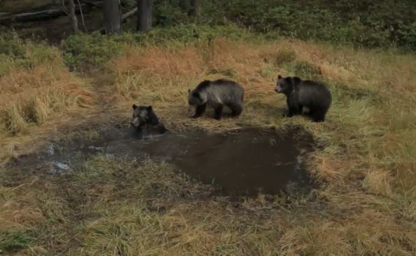
EXCLUSIVE: 'Bear Bathtub' Caught on Camera in Yellowstone
"Bear Bathtub, a colloquial name given to Yellowstone's own version of a natural swimming hole, can be a busy place for the national park's wildlife to drink and cool off. Camera traps rigged to document the comings and goings at the backcountry spring uncovered new insights into bear behavior."
________________________________
Thanks for checking in and have a great rest of your week and weekend ahead! Follow me on Twitter @TNelsonWX

No comments:
Post a Comment