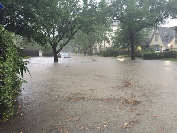
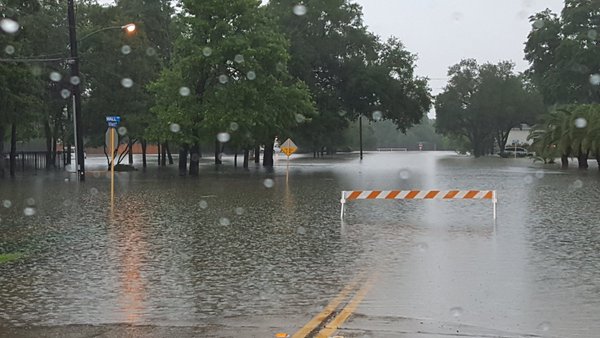
Monday was a VERY wet day for folks in eastern Texas, especially for those around Houston, TX, where reports of 10"+ came in. Flash Flood Emergencies were in effect and there were also reports of several water rescues as some got caught in the flood waters. Take a look the images below from around the Houston, TX area.
Here's an excerpt from USAToday regarding the flooding in Texas: "Drenching rain, which brought flash floods to much of eastern and southern Texas on Sunday and Monday, deluged Houston and led to scores of water rescues. It was one of the rainiest single days ever recorded in Houston, with nearly 10 inches of rain reported at the city's official weather observing location at the airport as of mid-afternoon. Hundreds of homes and many major roads were flooded out in the Houston area, forcing schools, governments and businesses to close and causing power outages for thousands of residents. Many areas reported over a foot of rain. One spot near Houston unofficially recorded as much as 20 inches. Nearly 900 water rescues were performed in the city of Houston alone, and 1,222 total in the metro area, according to Harris County officials."
See more from USAToday.com HERE:
(Photo Courtesy Twitter: @KClarke95)
(Photo Courtesy Twitter: @JVPD_Police)
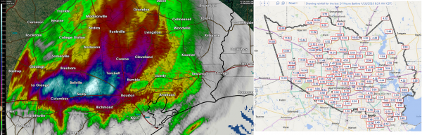
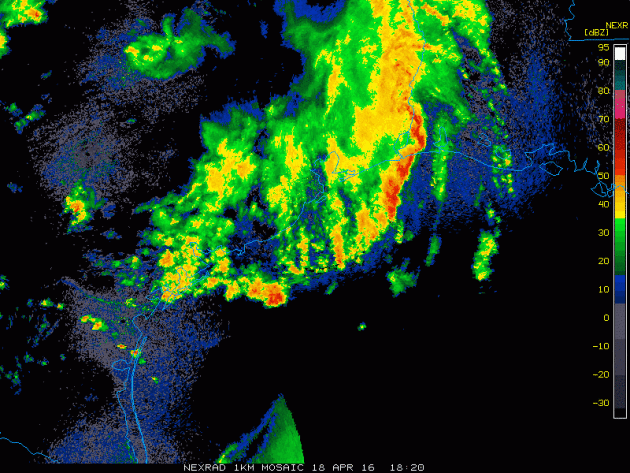
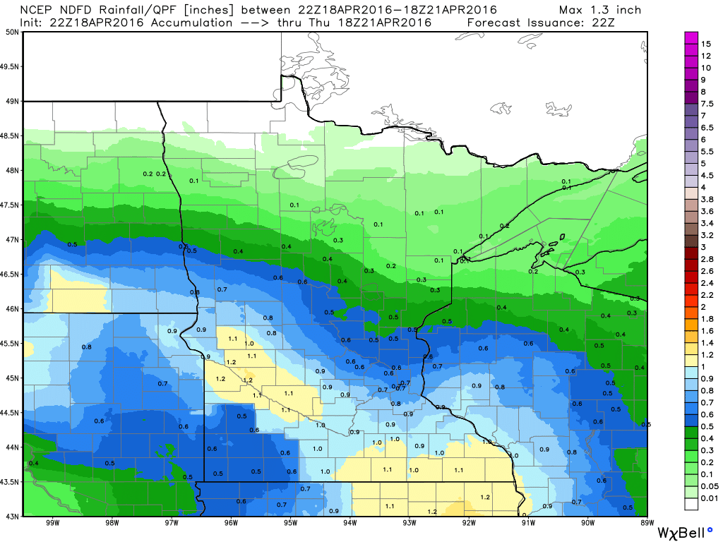
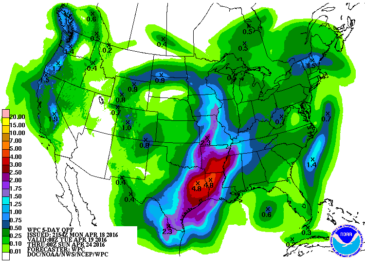
Here's a look at radar estimated rainfall, which suggests some 10" to 15"+ amounts. There was even an unofficial report of 20"!
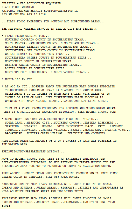
Here is one of the Flash Flood Emergencies that was issued by the National Weather Service for Houston and surrounding areas on Monday morning. Note the National Weather Service strong wording in this warning; "THIS IS AN EXTREMELY DANGEROUS AND LIFE-THREATENING SITUATION. DO NOT ATTEMPT TO TRAVEL UNLESS YOU ARE FLEEING AN AREA SUBJECT TO FLOOD OR ARE UNDER AN EVACUATION ORDER."
Radar Earlier Tuesday
The radar from the afternoon hours on Monday showed the heaviest rain shifting east of the area. However, additional rainfall can't be ruled out trough tomorrow. In fact, there is a flash flood watch in place until Tuesday morning, so additional an additional heavy rain could lead to more flooding.
Additional Rainfall
Additional rainfall potential could still near 2" to 4" with isolated 6"+ amounts through the end of the week. This could lead to additional flood concerns
Historic Houston Rain - Lighter Rains in Minnesota
By Todd Nelson, filling in for Douglas.
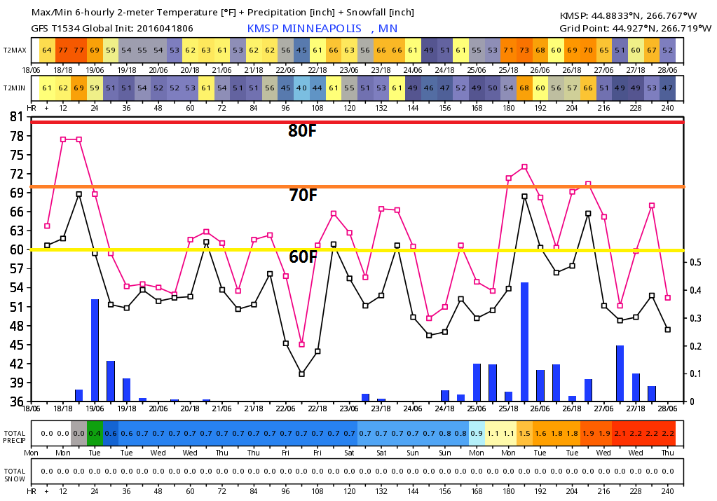
Lacking a little bounce in your step? I feel it too. Hey, I get it. We're coming off of the warmest weekend in nearly 6 months! Minnesotans earn their summers and we had a little taste of it over the last few days.
Cooler temps, cloudy skies and scattered showers will come by way of a slow moving storm system that was responsible for nearly 50 inches of snow in Pinecliffe, CO over the weekend and partly to blame for the historic rainfall in Houston, TX on Monday. Get this, Houston had one of their wettest day on record, the previous 10.34 inches was set on June 26, 1989.
Rainfall amounts will be significantly lighter for us over the next few days. Keep in mind that Twin Cities was running a yearly precipitation deficit of more than 1 inch prior to yesterday's rain. We're also running a fairly hefty snowfall deficit, which has grown to 17 inches in the Twin Cities.
This moisture is coming at a good time. It'll help the green up process and mitigate fire concerns some.
Think May flowers!
______________________
Extended Forecast
MONDAY NIGHT: Cloudy. Scattered rain showers. Winds: ENE 10. Low: 55.
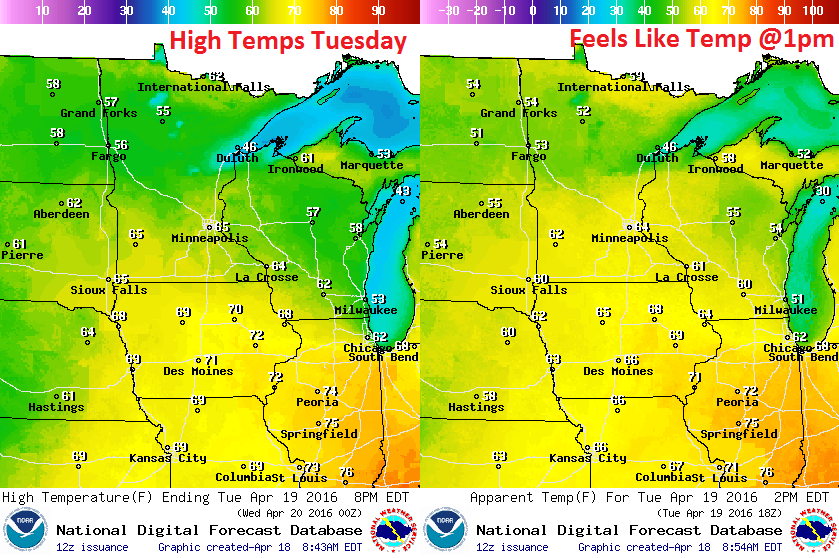
TUESDAY: Cooler and cloudier, scattered showers. Winds: E 8-13. High: 65.
TUESDAY NIGHT: Cloudy. A few passing showers. Winds: ESE 5-10. Low: 50
WEDNESDAY: Cloudy with scattered showers, heavier southeast. Winds: E 5-10. High: 63
THURSDAY: AM sprinkle, slow PM clearing and breezy. Winds: NNW 10-15. Wake-up: 49. High: 62.
FRIDAY: More sun, near average temps. Winds: SE 8-13. Wake-up: 43. High: 60
SATURDAY: Passing shower early, cool breeze.. Winds: NE 10-15. Wake-up: 47. High: 61.
SUNDAY: Dry start. Clouds thicken, PM shower? Winds: SE 10-15. Wake-up: 44. High: 60.
MONDAY: Increasing thunder risk. Winds: ESE 10-15. Wake-up: 45. High: 62.
______________________
This Day in Weather History
April 19th
1928: Chilly air moves across the region with a record low of 19 at the Twin Cities.
1893: A heavy snowstorm at Bird Island would last until the 21st. 17 inches of snow would fall, with drifts 3 to 4 feet high.
1820: The first tornado ever reported in Minnesota hits the camp that would soon become Ft. Snelling. It damages the roof of a barracks, with no one injured.
_______________________
Average High/Low for Minneapolis
April 19th
Average High: 60F (Record: 87F set in 1985)
Average Low: 39F (Record: 19F set in 1928)
________________________
Sunrise/Sunset Times for Minneapolis
April 19th
Sunrise: 6:21am
Sunset: 8:04pm
*Daylight gained since yesterday: ~2mins & 57secs
*Daylight gained since winter solstice: ~4hours & 57mins
_____________________________
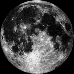
Moon Phase for April 19th
1.9 Days Until Full (Pink) Moon
_______________________________
Big Sunspot Erupts
Take a look at the big black spot on the surface of the from earlier this week. Interestingly, this sunspot is almost 5 times larger than Earth! This. Sunspots often are sources of XFlares and geomagnetic storms here on earth.
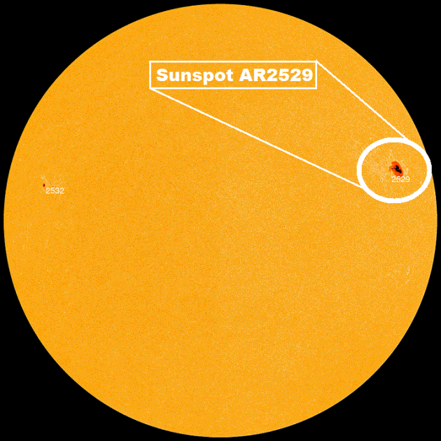
"Surprise! Quiet sunspot AR2529 isn't so quiet, after all. The heart-shaped active region erupted on April 18th (00:39 UT), producing a strongM6.7-class solar flare. NASA's Solar Dynamics Observatory recorded the flare's extreme ultraviolet flash:"

"A pulse of UV radiation from the flare ionized the top of Earth's atmosphere. This, in turn, disrupted shortwave radio communications over the daylit side of our planet. Mariners, aviators, and ham radio operators around the Pacific Ocean may have noticed fading signals at frequencies below ~15 MHz. A NOAA blackout mapshows the frequencies and territories affected. More M-class flares are possible in the days ahead. AR2529 has developed a 'beta-gamma' magnetic field that harbors plenty of energy for this kind of explosion. Although the sunspot is no longer directly facing Earth, it can still affect our planet by causing radio blackouts and glancing-blow CMEs. Stay tuned."
Watch for Northern Lights! Weather Permitting...
"NOAA forecasters say that a CME hurled into space by today's M6.7-flare might deliver a glancing blow to Earth's magnetic field on April 20th. High-latitude sky watchers should be alert for auroras during a possible G1-class geomagnetic storm."
See more from Spaceweather.com HERE:

__________________________
Tuesday Weather Outlook
After three days with highs nearing 80F in the Twin Cities (nearly 20F above average), highs in the 60s will feel relatively cool. However, keep in mind that our average highs is 60F, so we'll still be running slightly above average. Highs in the 60s look to persist through the rest of the week with spotty showers possible through Thursday.
Tuesday Weather Outlook
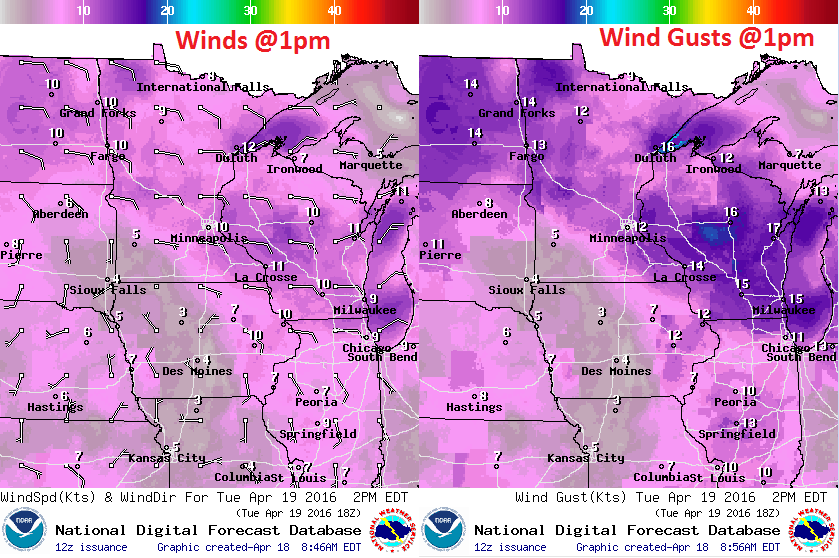
Winds will be more easterly on Tuesday, which will be a cooler wind that what we've been dealing with over the past several days. However, winds don't look to be quite as pesky as they were over the weekend.
Tuesday Weather Outlook
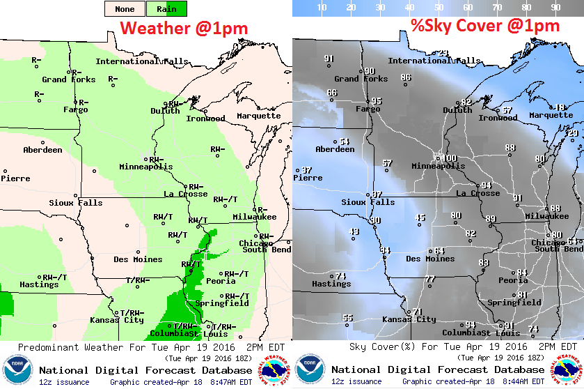
Rain looks to taper a bit on Tuesday across the Upper Midwest. However, another surge of heavier moisture looks to slide back north on Wednesday, which may push as far north as southeastern Minnesota.
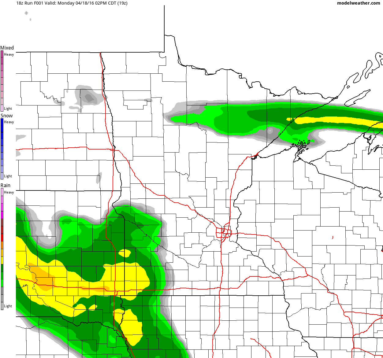
Simulated Radar
The simulated radar from midday Monday to Wednesday night shows the narrow band of precipitation lifting north through the region during the time frame. The heaviest of which looks to be with us through Tuesday before tapering a little by PM Tuesday.
Precipitation Outlook
Here's the rainfall potential through midday Thursday, which shows heavier rainfall potential of up to 1" along the Minnesota and in southeastern Minnesota.
__________________________________________
Extended Weather Outlook
After a few days with highs near 20F above average, we look to settle back into the 60s for the rest of the week as a slow moving low pressure system swirls through the region. It begins to loosen its grip on us by the end of the week, but we may not get back into the 70s again until late this weekend or next week. Stay tuned.
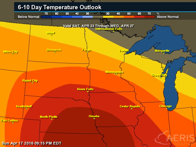
6 to 10 Day Temperature Outlook
According to NOAA's CPC, the 6 to 10 day temperature outlook suggests warmer than average temperatures continuing across much of the Central U.S. from April 23rd to April 27th.
_______________________________________
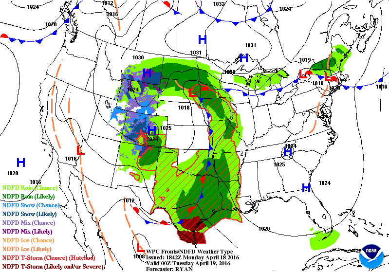
National Weather Outlook
The storm system in the Central U.S. will finally start moving a little faster as we head into the second half of the work week. The cutoff low will finally start merging with upper level winds, which will help to speed its easterly movement later this week. The heaviest rainfall still looks to stay across the southern half of the Mississippi River Valley, some of which could feature strong to severe thunderstorms across parts of Texas.
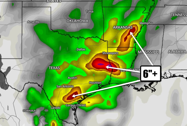
Precipitation Outlook
According to NOAA's WPC, the 5 day rainfall forecast suggests some 2" to 4"+ rainfall amounts across the Lower Mississippi Valley. This could lead to additional flooding as the ground is saturated from recent very heavy rains.
__________________________
US and China Lead Push to Bring Paris Climate Deal into Force Early
"The US and China are leading a push to bring the Paris climate accord into force much faster than even the most optimistic projections – aided by a typographical glitch in the text of the agreement. More than 150 governments, including 40 heads of state, are expected at a symbolic signing ceremony for the agreement at the United Nations on 22 April, which is Earth Day. It’s the largest one-day signing of any international agreement, according to the UN. But leaders will really be looking to see which countries go beyond mere ceremony and legally join the agreement, which would bind them to the promises made in Paris last December to keep warming below the agreed target of 2C. So far, the US, China, Canada and a host of other countries have promised to join this year - boosting the hopes of bringing the Paris deal into force before the initial target date of 2020 – possibly as early as 2016 or 2017, according to officials and analysts."
Thanks for checking in and have a great rest of your week!
Follow me on Twitter @TNelsonWX

No comments:
Post a Comment