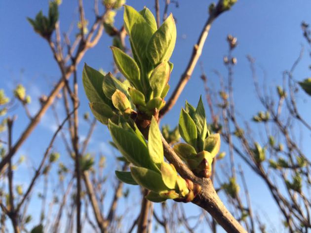
It's not easy being green... The long Minnesota winter is beginning to show signs of subsiding. As the threat of sub-freezing temperatures continues to dwindle, life is starting to emerge in resident trees and bushes. Grass is greening rapidly and perennials are emerging rapidly from their long winters nap. Spring is here, enjoy it!
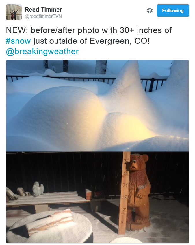
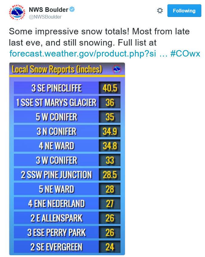
Incredible Colorado Snow Totals!!
The
slow moving storm system over the Rockies this weekend was responsible
for significant snowfall tallies in the mountains. Nearly 3 feet of snow
fell near Evergreen, CO and more than 40" of snow fell near Pinecliff,
CO! Now that's some serious spring snow! Several locations saw more than
2 feet in the higher elevations... WOW!
____________________________
Tree Explosion - Slow Low Brings Rain Chances
By Todd Nelson, filling in for Douglas
By Todd Nelson, filling in for Douglas
WOW! What a weekend! Although winds were a bit of a nuisance, we managed to see our first 80 degree high temp in the Twin Cities since October 11th. With temperatures running nearly 20 degrees above average, the fast forward spring seemingly coaxed trees into a budding frenzy. It appears that just about every tree is ready to pop, we're getting there!
A stalled storm system responsible for up to 40 inches of snow in the mountains of Colorado and severe storms in the Plains will begin wobbling our way today. Scattered showers and rumbles of thunder will be possible through midweek, but rainfall amounts look heavier south of us. Pesky clouds and showers begin to fade Thursday with more sun and highs near 70 degrees again by Friday.
The next storm system looks to arrive by the weekend with increasing chances of thundery downpours. Note that April is the 6th most thundery month in the Twin Cities, averaging 2.7 days of thunder. Even though we haven't seen much unsettled weather yet, we appear to be trending in that direction.
_____________________________
SUNDAY NIGHT: Mostly cloudy. Winds: SE 5-10. Low: 56.
MONDAY: Spotty shower or t-shower. Winds: ESE 5-15. High: 76
MONDAY NIGHT: Cloudy. Chance of showers and a rumble of thunder. Winds: ENE 10. Low: 52.
TUESDAY: Cooler and cloudier, isolated t-shower. Winds: ESE 8-13. High: 63.
WEDNESDAY: Lingering clouds and showers. Winds: E 5-10. Wake-up: 50. High: 64
THURSDAY: AM sprinkle, slow PM clearing. Winds: NNW 5-10. Wake-up: 52. High: 65.
FRIDAY: Increasing winds. PM thunder north. Winds: ESE 8-13. Wake-up: 47. High: 65SATURDAY: Warmer. Late day storm. Winds: SE 10-20. Wake-up: 52. High: 70.
SUNDAY: Breezy with scattered showers and storms. Winds: ENE 10-15. Wake-up: 50. High: 66.
______________________________
This Day in Weather History
April 18th
2004: A strong cold front whips up winds of up to 55 miles an hour over southern Minnesota. The wind causes black clouds of soil to lift into the air, creating soil erosion and reduced visibility. Some old-timers remarked that it reminded them of the dust storms from the 1930's Dust Bowl era.
2002: Baseball-sized hail falls in Eagan, creating small craters in the soft ground and broken windows in apartments.
1977: A tornado touches down at the mouth of the Minnesota River.
_______________________________
Average High/Low for Minneapolis
April 18th
Average High: 59F (Record: 89F set in 1985)
Average Low: 38F (Record: 21F set in 1953)
_________________________________
Sunrise/Sunset Times for Minneapolis
April 18th
Sunrise: 6:22am
Sunset: 8:03pm
*Daylight gained since yesterday: ~2mins and 57seconds
*Daylight gained since winter solstice (Dec. 21st): ~4hours and 54mins
___________________________________
Moon Phase for April 18th at Midnight
2.9 Days Until Full (Pink) Moon
_____________________________________
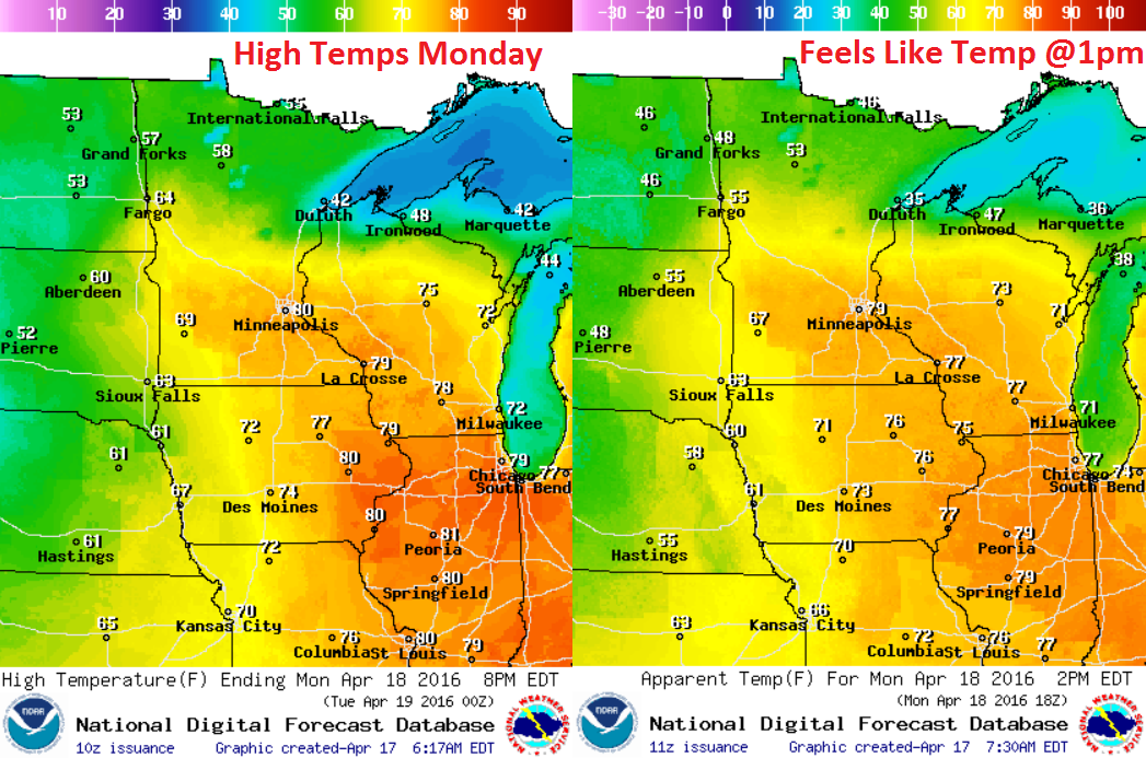
Monday Weather Outlook
Monday appears to be another very mild day with the high temp near 80 degrees once again in the Twin Cities. As the storm system continues to slowly slide east, temperatures will begin to fall across the northern half of the state. This appears to be the last very mild day for a little while as temperatures cool into the 60s for much of next week.
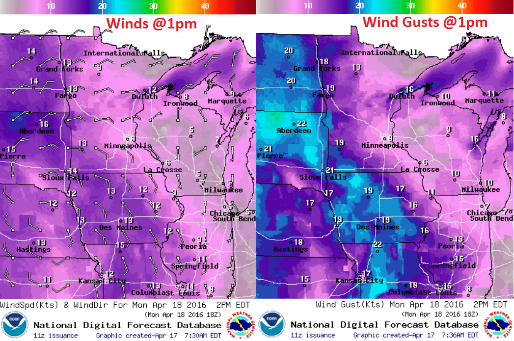
Monday Weather Outlook
Winds begin to turn more easterly as the storm system slowly approaches from the southwest. Winds will also be a little breezy across the southwestern part of the state.
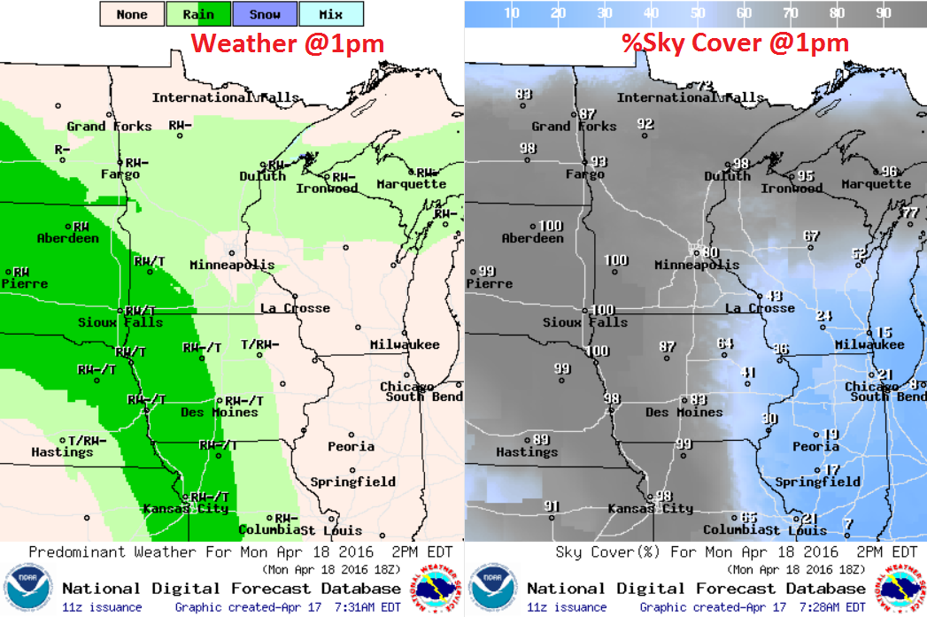
Monday Weather Outlook
Here's the weather depiction around Midday Monday, which shows the heaviest, steadiest rain moving into southwestern Minnesota. It appears rainfall chances will continue to increase overnight Monday into Tuesday.
Simulated Radar
The simulated radar from midday Sunday to Tuesday night shows waves of moisture lifting through the Upper Midwest. It appears the heaviest will slide through late Monday night into Tuesday, however, the heaviest looks to stay southwest of the Twin Cities.
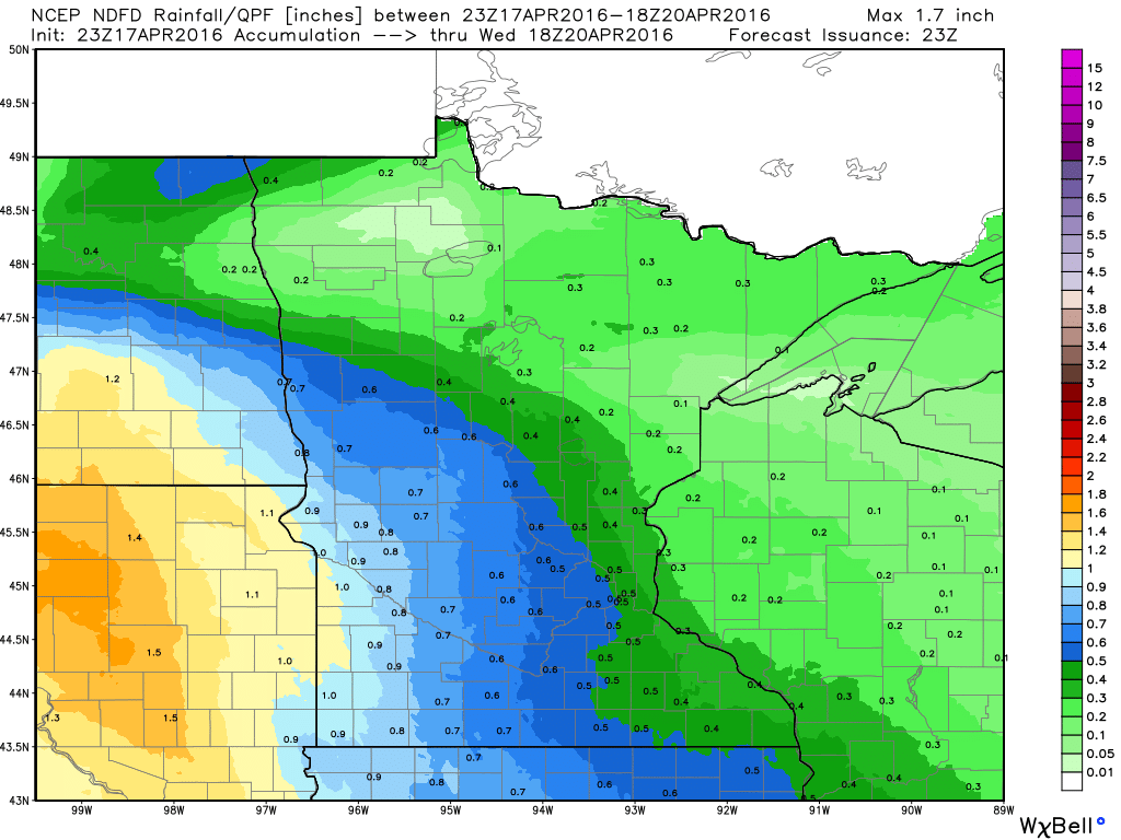
Precipitation Outlook
The precipitation potential through midday Wednesday suggests heavier rainfall across South Dakota with as much as 1.5" possible. Up to 0.5" amount may be possible around the Twin Cities with even lighter amounts across the northern parts of Minnesota and into Wisconsin.
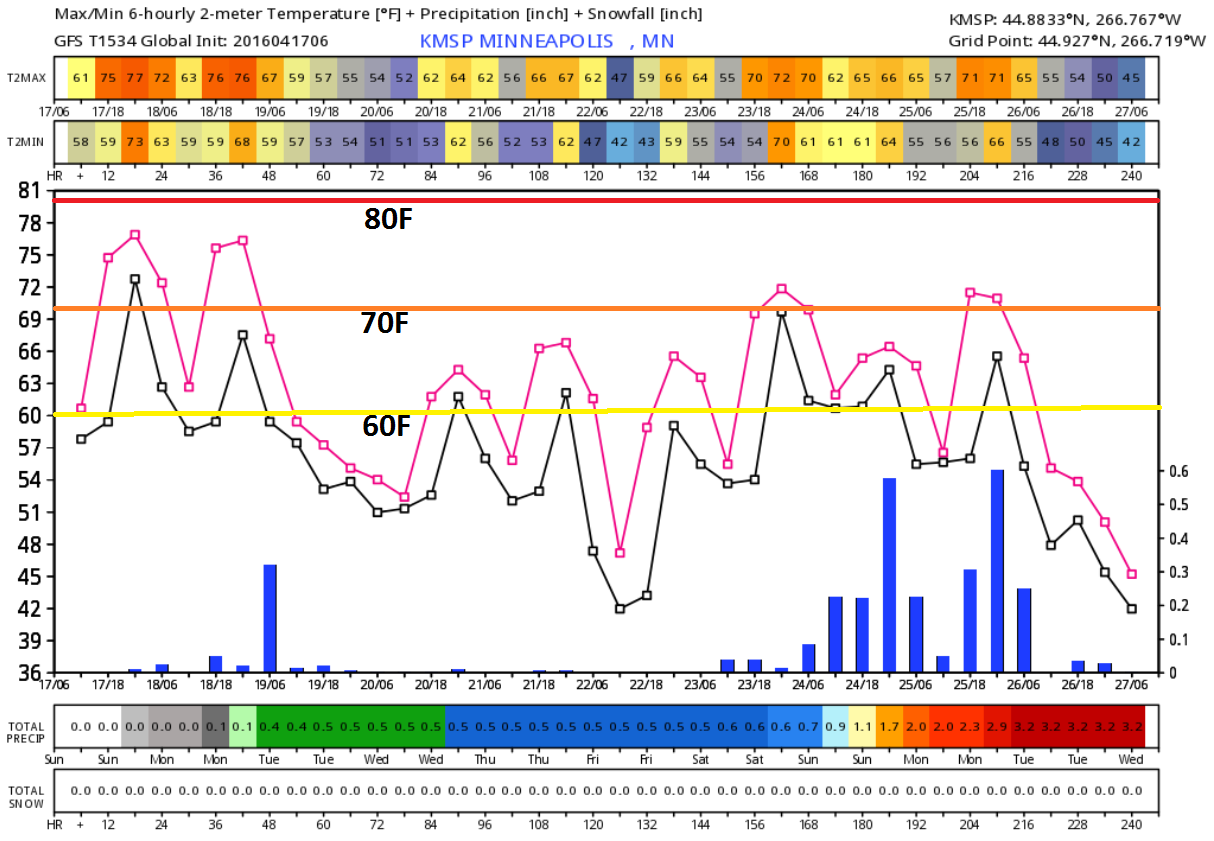
Extended Weather Outlook
Temperatures were running nearly 20 degrees above average this week and may still be that warm in the Twin Cities on Monday before dipping into the 60s through the rest of the week. Highs in the 60s will come by way of more clouds and scattered showers. If you've been enjoying the warmer weather as of late, highs around 70 degrees looks to return by the weekend... stay tuned.
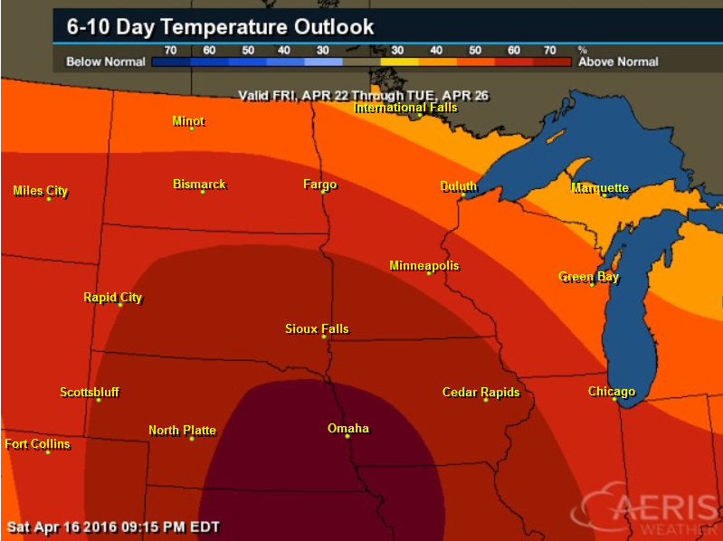
6 to 10 Day Temperature Outlook
Warmer than average temperatures continues... According to NOAA's CPC, the 6 to 10 day temperature outlook suggests warmer than average temperatures continuing into next weekend.
___________________________________
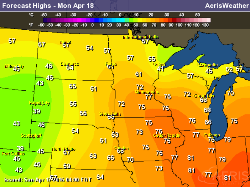
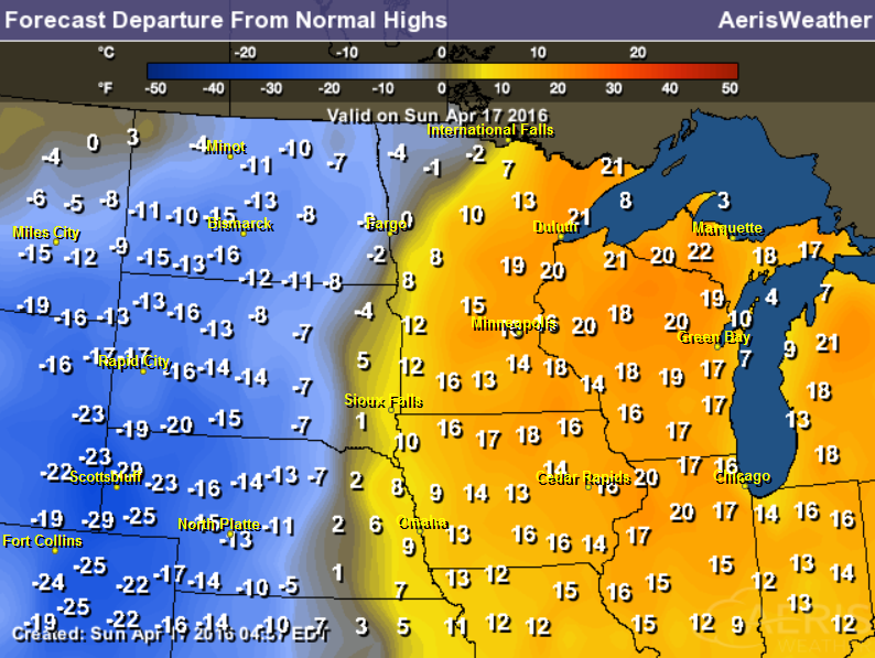
A Mild Monday
The Midwest high temperature map on Monday looks very mild for mid-April. In fact, temperatures will feel more like May across parts of Iowa, Wisconsin and southern Minnesota.
________________________________
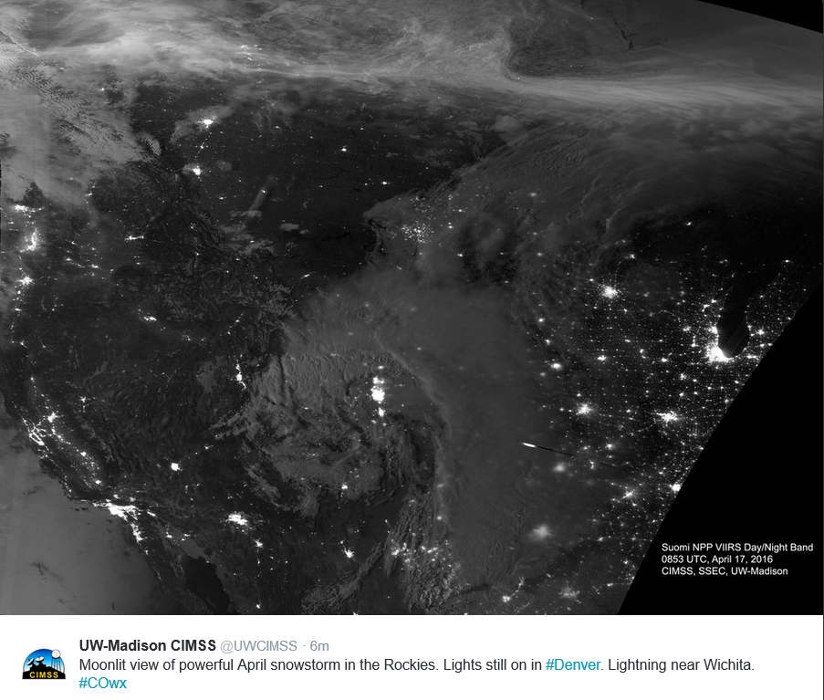
Satellite Image of Storm System
Here's a cool image from the folks over at UW-Madison CIMSS, which shows the storm system that brought up to 40" of snow to parts of Colorado and severe storms to the Plains. The satellite image was taken at night, so the bright lights show the major cities of Chicago on the southwest side Lake Michigan to San Diego and Los Angeles in Southern California. If you can navigate your way around the may, you can even see Minneapolis/St. Paul!
National Weather Outlook
The national weather outlook shows the slow low moving east into the Central U.S. through PM Tuesday. Heavy wintry precipitation will begin to fade over the Rockies and the Front Range, while rain and scattered thunderstorms will shift east into the Mississippi River Valley.
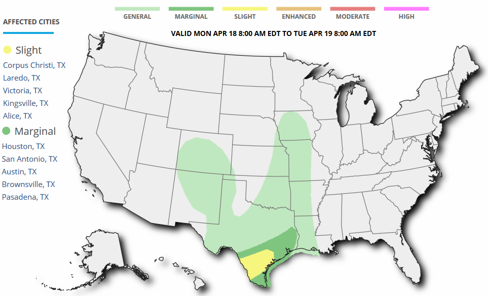
Severe Weather Threat Monday
...SUMMARY...
   A FEW STRONG TO SEVERE STORMS WITH A THREAT FOR MAINLY STRONG WIND
   GUSTS AND MARGINALLY SEVERE HAIL REMAIN POSSIBLE OVER SOUTH THROUGH
   SOUTHEAST TEXAS MONDAY AFTERNOON AND EVENING.

   ...SYNOPSIS...

   A CUTOFF UPPER LOW NOW CENTERED OVER CO WILL DRIFT VERY SLOWLY NEWD
   MONDAY. BY 12Z MONDAY AN OCCLUDED FRONT WILL EXTEND FROM A WEAK SFC
   LOW OVER THE CNTRL PLAINS SSWWD WHERE IT WILL STALL FROM CNTRL INTO
   SWRN TX. NRN PORTION OF THE FRONT WILL SHIFT EWD INTO THE MID-UPPER
   MS VALLEY...WHILE SFC LOW DEVELOPS NWD INTO SD.
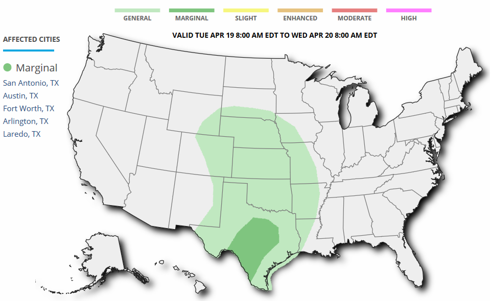
Severe Threat Tuesday
...SUMMARY...
   A MARGINAL SEVERE THREAT MAY DEVELOP ACROSS PARTS OF SOUTHWEST AND
   CENTRAL TEXAS TUESDAY AFTERNOON AND EVENING.
5 Day Precipitation Outlook
According to NOAA's WPC, the 5 day precipitation outlook suggests heavy rainfall continuing across the Southern Plains with significant rainfall potential possible along the Gulf Coast in Texas. The maximum there suggests nearly 10" of rain through PM Friday!
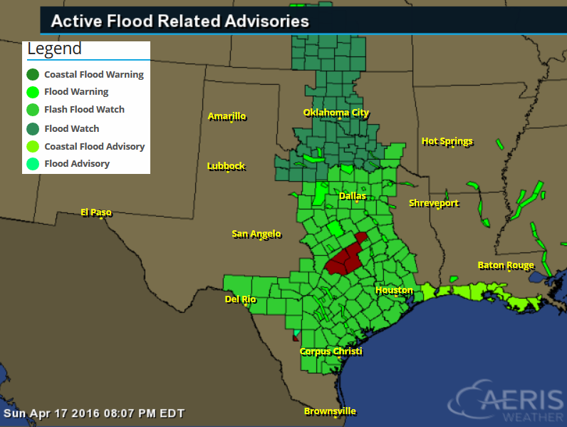
Flood Concerns
As heavy rain continues in the Central U.S., the heaviest will be focused in the Southern U.S. (mainly Texas) over the next few days. Flooding concerns will continue through Tuesday where 3" to 5" (isolated 8") may be possible.
* THROUGH TUESDAY MORNING

* THUNDERSTORMS ARE EXPECTED TO DEVELOP AND MOVE INTO THE WATCH
  AREA FROM CENTRAL TEXAS. SOME OF THESE STORMS WILL BE CAPABLE OF
  VERY HEAVY RAINFALL WHICH MAY PRODUCING FLASH FLOODING. SOME
  STORMS MAY MOVE OVER SOME OF THE SAME AREAS THAT RECEIVED HEAVY
  RAINFALL WHICH WILL ONLY PROLONG THE THREAT FOR FLASH FLOODING.
  THE GREATEST THREAT FOR FLASH FLOODING APPEARS TO BE FROM
  COLLEGE STATION TO CROCKETT TONIGHT INTO MONDAY MORNING. ANOTHER
  ROUND OF STORMS COULD AFFECT THE SAME AREA MONDAY NIGHT INTO
  TUESDAY. THE THREAT FOR FLOODING MAY EXPAND DURING THIS TIME TO
  INCLUDE THE HOUSTON AREA AND GULF COAST. THREE DAY RAINFALL
  AMOUNTS FROM TODAY THROUGH TUESDAY ARE EXPECTED TO BE AROUND 3
  TO 5 INCHES ACROSS THE AREA WITH ISOLATED AMOUNTS OF GREATER
  THAN 8 INCHES.

* FLOODING IMPACTS ARE EXPECTED TO BE FLOODING OF LOW LYING
 ROADS AND LOW WATER CROSSINGS. EXPECT RAPID INCREASES ON AREA
 RIVERS AND CREEKS. PROLONGED RIVER FLOODING COULD RESULT FROM
 RUNOFF OF THE EXCESSIVE RAINFALL.
_______________________________
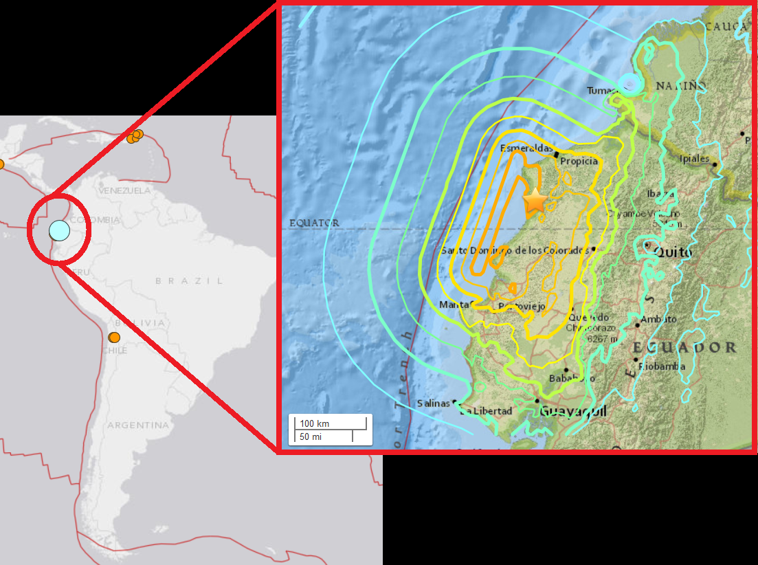
7.8 Magnitude Earthquake in Ecuador
Here's an excerpt from APTheBigStory about the strong earthquake in Ecuador:
"PEDERNALES, Ecuador (AP) — The strongest earthquake to hit Ecuador in decades flattened buildings and buckled highways along its Pacific coast, sending the Andean nation into a state of emergency. As rescue workers rushed in, officials said Sunday at least 77 people were killed, over 588 injured and the damage stretched for hundreds of miles to the capital and other major cities. The magnitude-7.8 quake, the strongest to hit Ecuador since 1979, was centered on Ecuador's sparsely populated fishing ports and tourist beaches, 170 kilometers (105 miles) northwest of Quito, the capital. Vice President Jorge Glas said there were deaths in the cities of Manta, Portoviejo and Guayaquil — all several hundred kilometers (miles) from the center of the quake struck shortly after nightfall. In Pedernales, a town of 40,000 near the quake's epicenter, dozens of scared residents slept in the streets while men equipped with little more than car headlights tried to rescue survivors who could be heard trapped under rubble."
See more from APTheBigStory HERE:
7.8 Magnitude Earthquake in Ecuador
"The April 16, 2016 M 7.8 earthquake, offshore of the west coast of northern Ecuador, occurred as the result of shallow thrust faulting on or near the plate boundary between the Nazca and Pacific plates. At the location of the earthquake, the Nazca plate subducts eastward beneath the South America plate at a velocity of 61 mm/yr. The location and mechanism of the earthquake are consistent with slip on the primary plate boundary interface, or megathrust, between these two major plates. Subduction along the Ecuador Trench to the west of Ecuador, and the Peru-Chile Trench further south, has led to uplift of the Andes mountain range and has produced some of the largest earthquakes in the world, including the largest earthquake on record, the 1960 M 9.5 earthquake in southern Chile."
See more from the USGS HERE:
Cyclone Fantala
Take a look at Cyclone Fantala from early Sunday in the South Indian Ocean. Fantala was expected to make a U-turn and stay offshore, but dangerously close to Madagascar.
________________________________
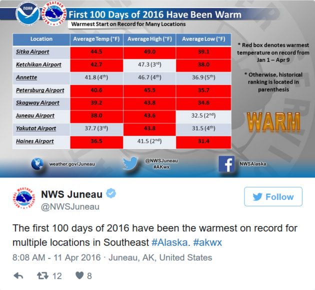
Unrelenting Winter Warmth Could Herald Alaska's Future
"The first 100 days of 2016 were record warm for many spots around Alaska, continuing a pattern of warmth that has gripped the state over much of the last three years and looks to continue for at least the next few months. The prolonged period of decidedly unusual balminess — the result of a particular combination of climate factors (and a nudge from long-term global warming) — comes with concerns for an earlier wildfire season, salmon die-offs and damage to roads and other infrastructure as seasonally frozen ground thaws early."
See more from ClimateCentral.org HERE:
Thanks for checking in and have a great week ahead!
Follow me on Twitter @TNelsonWX

No comments:
Post a Comment