58 F. high in the Twin Cities Tuesday.
68 F. average high on May 10.
60 F. high on May 10, 2015.
.59" rain fell at MSP International Airport as of 7 pm yesterday.
.75" additional rain predicted for today and tonight at MSP (00z NAM model).
May 11, 1915: A waterspout is seen on Lake Mills.
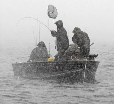
Stumbling Into Spring - Chilly Fishing OpenerA bad day of fishing is better than a good day of work. This upcoming
Saturday I'm torn between fishing and pumpkin-carving, maybe tossing the football. Minnesota's Fishing Opener is
May 14, but I have a sneaking suspicion it will look and feel more like
October 14.
We're
paying a price for 92 degrees last Friday; the weather pendulum now
swinging in the opposite direction. In fact it may be marginally cold
enough aloft for a light mix of rain and wet snow up north early
Saturday
morning. No accumulation expected, but sunrise wind chills may dip into
the 20s from the Whitefish Chain to Leech Lake. Pack a jacket or
sweatshirt and hope for the best.
No need to water the lawn this
week. Another band of heavy showers arrives today; a clap of thunder is
possible; the atmosphere too cool and stable for anything severe. We dry
out
Thursday
but a reinforcing swipe of Canadian air surges south by late week. A
light frost is possible for greater Minnesota next weekend, but models
hint at 70s the weekend of
May 21-22.
One big silver lining: cool air keeps the tornadoes away.
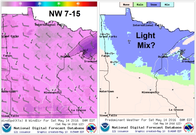
Fishing Opener: Touch of October.
Right now it looks blustery and cool Saturday with a few light rain and
snow showers over northern Minnesota, a stiff northwest wind at 7-15
mph with a healthy walleye chop. NOAA maps above valid
8 am Saturday morning.
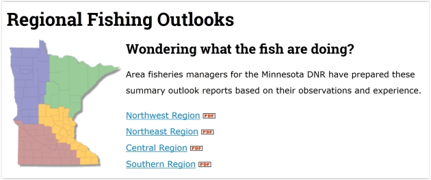
Wondering What The Fish Are Doing? The Minnesota DNR takes a look and helps to set expectations.
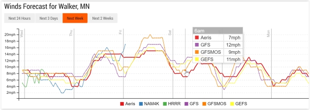
Gusty Friday - Winds Ease Slightly for Fishing Opener.
Sustained winds are forecast to drop into the 7-12 mph range by sunrise
Saturday morning on Leech Lake, a few gusts as high as 15-20 mph by
late morning and midday.
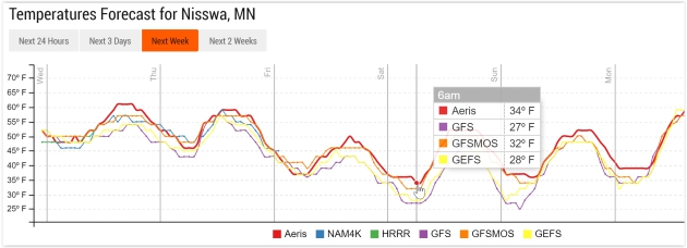
May Sweatshirts.
I would highly recommend taking more warm clothing to your favorite
lake than you think you'll need - you can always take off a layer or
two. Wake-up temperatures on Pelican, Gull and the Whitefish chain may
be hovering near freezing Saturday morning around 6 am, and that's
without the wind chill factor.
Probably Frost-Free in the Immediate Metro Area.
Air temperatures should stay just above freezing within the 494/694
freeway system Saturday morning, but if you live in an outlying suburb
and you want to keep those emerging annuals safe - consider covering
them up with plastic or newspaper before you go to sleep Friday night.
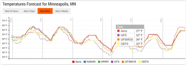
Temperature trend: NOAA and Aeris Enterprise.
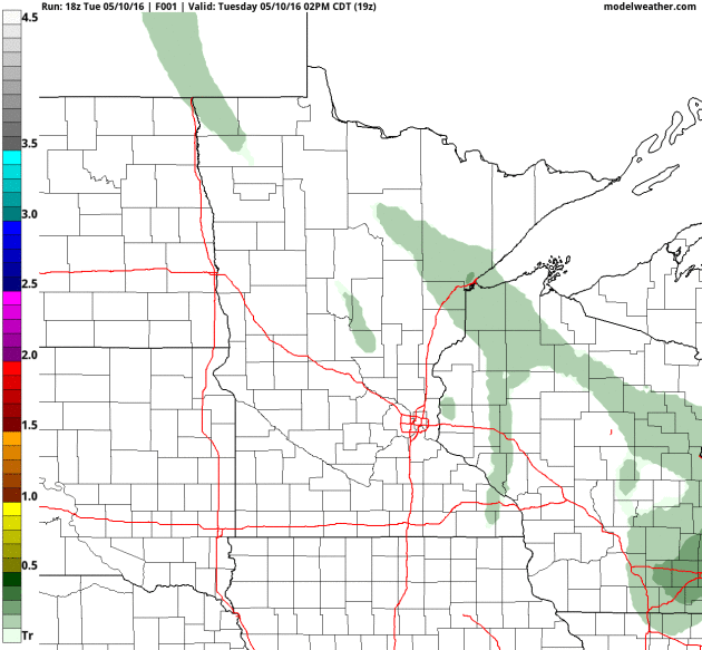
One More Rainy Shot.
The arrival of cooler air sets off another squall of rain and possible
thunder later today and tonight. Although I don't expect anything severe
4 KM NAM guidance hints at some .5 to .75" rainfall amounts, maybe an
inch or more on the east side of St. Paul. Loop: NOAA and AerisWeather.
Ouch.
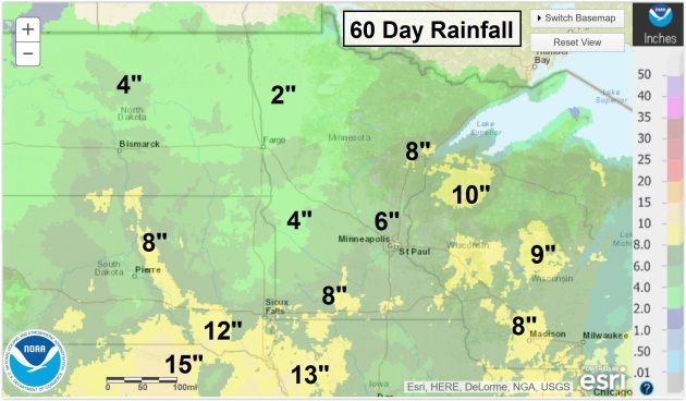
Proving that Minnesota is a big, diverse state with big, diverse
weather, I received the following note from a reader in Worthington who
points out weather for extreme southwestern Minnesota bears little
resemblance to what the rest of the state is experiencing right now.
Kevin Busch writes: "Wow, you are certainly out of touch with SW
Minnesota (Worthington) area. I have had over 6 inches of rain since
April 18th. We are flooding down here! Did you know that? Anyway, we
can't get our crops planted and the few that did get planted the middle
of April are having to be ripped up again because the waterlogged cold
soils didn't allow for the crops to come up. t has just been a plain
awful Spring down here. And this weeks cold and especially WET weather
is just what we do not need. We need hot and dry, and soon. And as far
as a mild, snow-free Winter...... Check your records for the snowfall
amount for the Winter in Worthington. Somewhere near 80 inches or so?
Here in this part of the country we would welcome some "global warming".
Just thought I'd let you know what it's like out here in fly-over land.
Thanks!"
60-Day Rainfall Estimates:
NOAA.
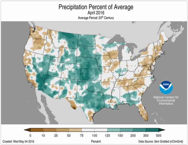
April Weather Summary. Here's an excerpt from
NOAA NCDC: "...
Above-average
precipitation was observed across the Great Plains and Rocky Mountains.
Seven states throughout the Great Plains, stretching from Montana to
Texas, had an April precipitation total that was much above average.
- Several
rounds of heavy precipitation impacted parts of Texas during April
causing widespread flooding. Houston was hit particularly hard on April
18 when 9.92 inches of rain was observed at the George Bush
Intercontinental Airport; even higher amounts were observed to the
northwest of the city. This was the second highest one-day precipitation
total for the city, bested only by the 10.34 inches that was observed
during Tropical Storm Alison in 1989. As a whole, Texas had its ninth wettest April with nearly 180 percent of average rainfall..."
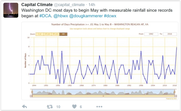
Think It's Wet Here? Washington D.C. just went
14 days in a row with measurable rainfall - a new record.
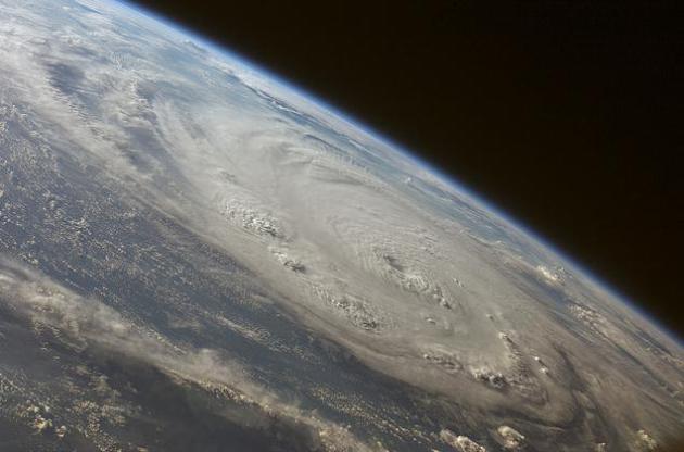
Chaos Limits Predictability of Hurricane Intensities.
Models are doing a pretty good job with hurricane track, but intensity
remains a huge challenge - and there may be limits to how accurately we
can predict hurricane intensity. Here's an excerpt from a new paper
highlighted at
Physics Today: "...
Yet
the errors in forecasts of hurricane intensity don't go away as one
might expect; rather, speed errors level off at about 8 m/s (18 mph)
after four to five days in real-time intensity forecasts. Through
full-physics simulations, the pair discovered that those errors arise
from a so-called chaotic attractor at the maximum potential intensity
limit. That finding implies that improvements in intensity forecasts are
more likely to come from better modeling of the large-scale environment
than from better knowledge of the storm's initial state. Even so, the
researchers note, the maximum range of predictability is only about
three days, and likely shorter for mature hurricanes..." (File image of 2007 Hurricane Felix: NASA).
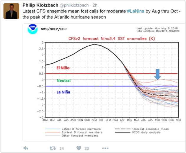
Do Warm Waters Off the East Coast Imply an Increased Hurricane Threat? Here's the intro to an interesting post at
Capital Weather Gang: "
The
start of the 2016 Atlantic hurricane season is just three weeks away,
and initial seasonal hurricane predictions have ranged from near-average
(by Colorado State University, Tropical Storm Risk and several private
groups) to above-average (by AccuWeather and the Weather Company)
activity. Some meteorologists are pointing to warmer-than-normal sea
surface temperatures (SSTs) near the East Coast to advertise an
increased hurricane threat to the U.S. coastline. Our analysis does not
support this argument. We actually find the risk of landfalling
hurricanes is highest when temperatures near the East Coast are cooler..."

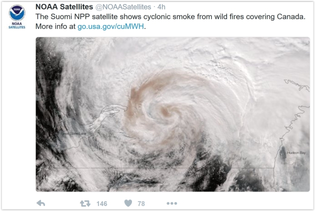
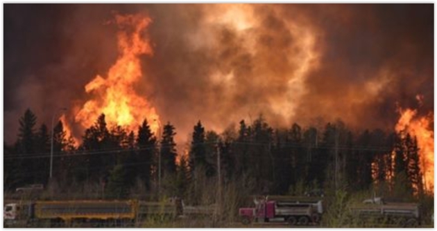
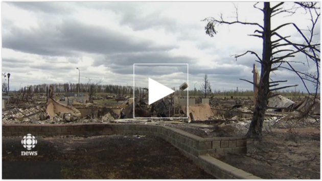
Alberta's Mega-Wildfire: Is California Next? Here's a video and story excerpt from
Yahoo Finance: "
For Californians, Alberta's gargantuan blaze is a reminder that the Golden State
has faced its own super-fires over the years — and officials warn that
the risks are worsening. El Nino-fueled storms have brought some relief
to drought-parched California this year, but the central and southern
portions of the state, as well as the Sierra Nevada foothills in the
north remain at high risk, according to experts. The state's peak
wildfire season comes in late July or August, with the hot, dry
conditions, although the danger will last well into the fall months.
California last year "had two of the top-10 most devastating fires in
the state's history — very similar conditions to what's occurring in
Canada right now," said Ken Pimlott, chief of the California Department
of Forestry and Fire Prevention (CalFire)..."
The 35 Strangest Weather Events I've Seen in my Lifetime. Jon Erdman has an interesting post at
weather.com; here's the intro: "
Some
weather events are so strange they capture the fascination of even the
most grizzled meteorologists. A thunderstorm with quarter-size hail, a
menacing shelf cloud,
or even a full-fledged blizzard are certainly impressive. But some
storms are exceptional in magnitude, extremely rare for a given area or
time of year, or, just flat out bizarre. While a full history of the
strangest weather is beyond the scope of this piece, I thought I'd take a
look at some of the most bizarre things in weather I've seen in my
lifetime, dating to the early 1970s. I'd love to rank these, but
they're all so bizarre in their own way. So enjoy this look at weather's
weird side..."
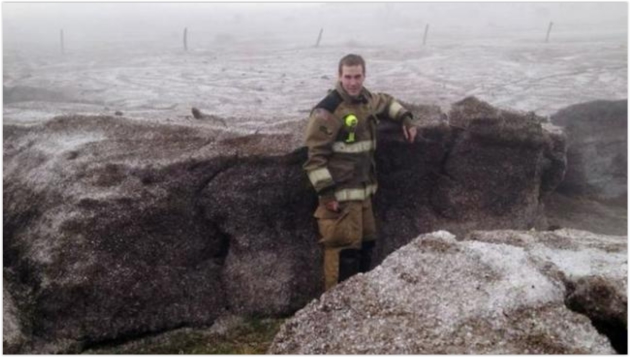
Photo credit above: "
Potter
County, Texas, firefighter Matt Dryden stands next to a wall of
accumulated hail north of Amarillo, Texas after an April 11, 2012 storm."
(Amarillo/Potter/Randall Office of Emergency Management).
Tornado Approaching? Ditch the Bathtub for a Ditch. This, according to storm chasing and tornado research pioneer Warren Faidley, interviewed at Yahoo News: "If you think you should hide in a bathtub when a tornado approaches,
think again. With tornado season at its height, storm chaser Warren
Faidley shared survival tips with INSIDE EDITION -- and using a bathtub
for shelter isn't one of them. "It's a bad idea," he said. While bathtubs were once made of cast iron, today they're too flimsy to be any help in a storm, he explained..."
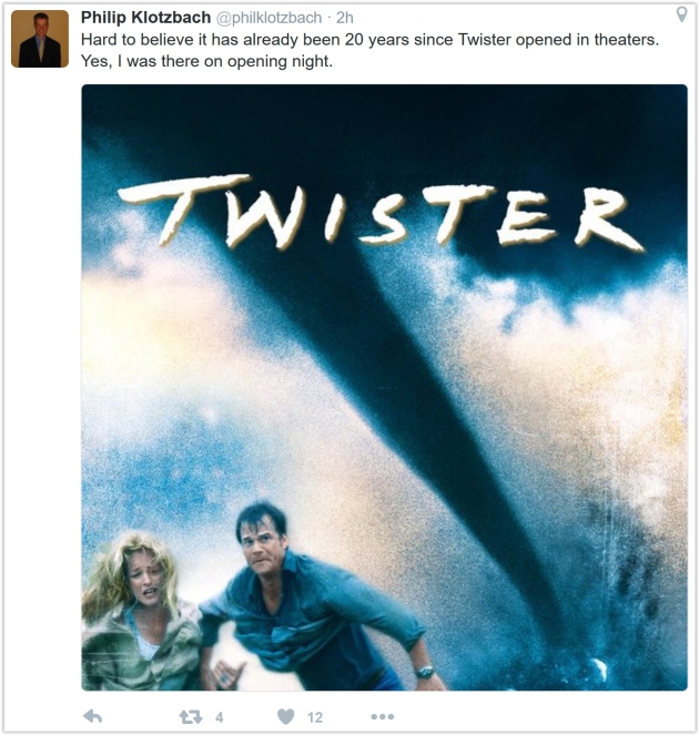
Behind The Scenes of "Twister". Thanks to Dan Holiday at
Tornado Talk
for a recent interview focused on my experience producing special
effects for the movie "Twister". I can't believe it's been 20 years.
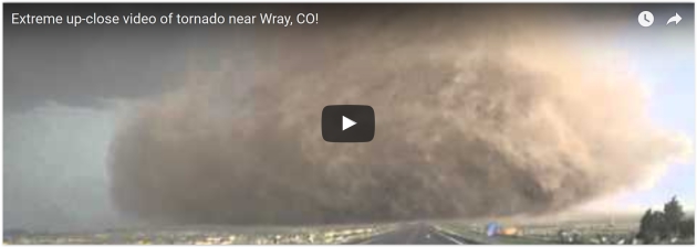
Man Captures Some of the Most Dramatic Footage Ever Taken of a Tornado. That's quite a mouthful, but the video is compelling. Here's a link and story excerpt from
San Antonio Express-News: "..
.A
video posted on YouTube Saturday shows some of the most dramatic
up-close footage of a tornado ever captured on film. According to the
Associated Press, a tornado hit just north of Wray, Colo., Saturday
evening about 7 p.m. It injured five people was one of several tornadoes
that hit Colorado Saturday. The AP wrote that storm chasers tracked the
tornado for about 10 miles once it hit the ground..."
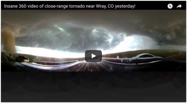
Try Not To Freak Out Inside This 360 Degree View of a Tornado. Esquire has a link to video from last weekend's outbreak near Wray, Colorado - here's a clip: "...
The
beast was caught on camera in a 360-degree video that documented the
tornado as it gained strength, dust, and debris. The sky turned, the
wind whipped, and raindrops fell as the vehicle—and camera, and the
driver—approached the storm. Be sure to drag the cursor over the video
to experience the full effect, and take a moment to appreciate the
bravery (idiocy?) of those poor saps running straight towards the
twister..."
John Oliver's Rant About Science Reporting Should Be Taken Seriously. It's well worth 20 minutes of your time, as explained at
Ars Technica: "...
Science
is a process that gradually builds accurate pictures of the natural
world. It's not always reliable in its details, but the more general
conclusions produced by science are usually pretty accurate. By
constantly focusing on the details, it's easy to get the impression that
anything goes—this month's conclusions are likely to be overturned in a
few weeks. But for many topics—evolution, vaccine safety, climate
change—the evidence is comprehensive and extremely internally
consistent. If we want people to accept those conclusions, we can't be
feeding them a constant stream of stories that indicate the process that
brought us to them produces unreliable nonsense. Unfortunately, we
continue to do exactly that."
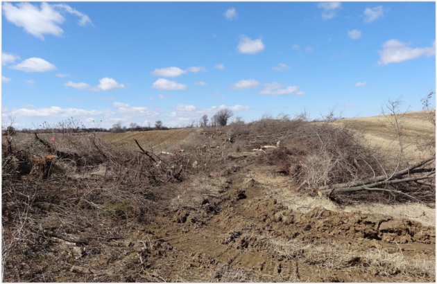
Tree Removal for Minnesota Solar Project Prompts Legislative Action. Here's an excerpt from
Midwest Energy News: "
In
addition to a countywide moratorium, a controversy over the removal of
trees for a Minnesota solar project has prompted an amendment in the
state legislature. The amendment, offered by state Rep. Marion O’Neill,
would prohibit solar projects if more than 75 percent of the trees in an
area larger than three acres would have to be cut down. The bill to which her amendment was attached cleared the Minnesota House on April 27, though the Senate has yet to take it up..."
Photo credit: "
This photo posted by Buffalo Township, Minnesota shows trees cleared for a planned solar project."
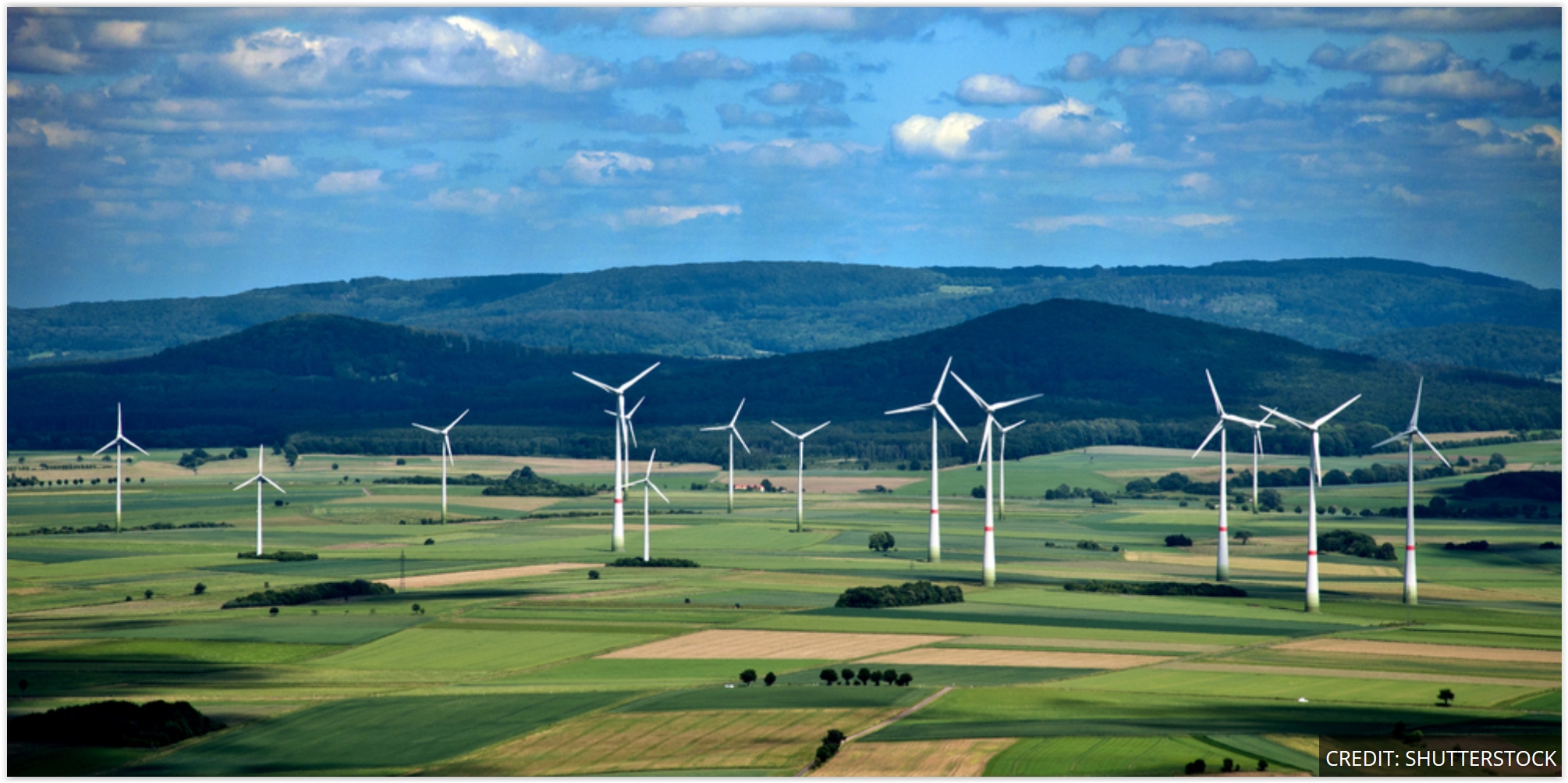 The 4th Largest Economy in the World Just Generated 90% of the Power It Needs from Renewables
. Here's a clip from
ThinkProgress: "
On
Sunday, for a brief, shining moment, renewable power output in Germany
reached 90 percent of the country’s total electricity demand. That’s a
big deal. On May 8th, at 11 a.m. local time, the total output of German
solar, wind, hydropower, and biomass reached 55 gigawatts (GW), just
short of the 58 GW consumed by every light bulb, washing machine, water
heater and personal computer humming away on Sunday morning. See the
graph below, courtesy Agora Energiewende, a German clean energy think tank..." (Photo credit: Shutterstock).
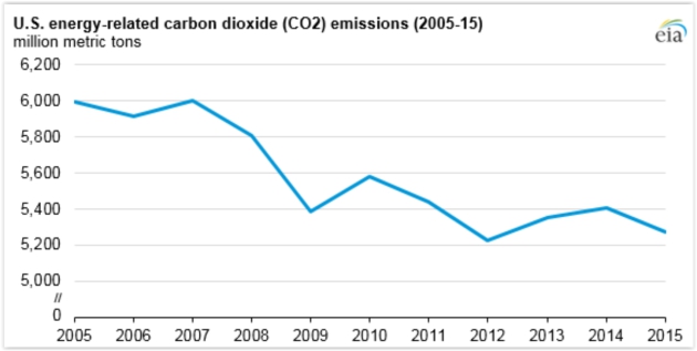
U.S. Energy-Related Carbon Dioxide Emissions in 2015 are 12% Below Their 2005 Levels. CO2 levels are receding, while the economy continues to grow (slowly). Here's an excerpt from
EIA: "
After
increasing in 2013 and in 2014, energy-related carbon dioxide (CO2)
emissions fell in 2015. In 2015, U.S. energy-related carbon dioxide
emissions were 12% below the 2005 levels, mostly because of changes in
the electric power sector. Energy-related CO2 emissions can be reduced
by consuming less petroleum, coal, and natural gas, or by switching from
more carbon-intensive fuels to less carbon-intensive fuels. Many of the
changes in energy-related CO2 emissions in recent history have occurred
in the electric power sector because of the decreased use of coal and
the increased use of natural gas for electricity generation..." (
Graphic source:
U.S. Energy Information Administration, Monthly Energy Review).
Are You The Family Tech Support.
Increasingly it's our kids (and grandkids) who are helping us manage
our digital appliances, but that doesn't come without new sources of
stress and irritation, reports the Wall Street Journal, which adds: "...Talk
through what needs to be done and ditch technical terms, Mr. Meister
says. Use analogies instead. When explaining what an antivirus program
can do, he often equates it to a raincoat. It will keep you dry in the
rain but it can only go so far; you’ll still get wet if you jump into a
lake. When recommending a new device, look for the simplest option. If a
parent wants to use a laptop only for email and social media, perhaps a
tablet would suffice. Ask for the make and model of whatever they get,
Mr. Meister says, so you can access a support page or an instruction
manual remotely, if necessary..."
TODAY: Showers likely, few T-storms. Winds: SE 7-12. High: 63
WEDNESDAY NIGHT: Showers taper - partial clearing. Low: 50
THURSDAY: Rare sunshine sighting possible. Winds: NW 10-20. High: 64
FRIDAY: Cooler breeze, pop-up PM shower? Winds: NW 15-25. Wake-up: 47. High: 56
FISHING OPENER SATURDAY: AM sun, PM showers - chilly. Winds: NW 15-25. Wake-up: 38. High: 55
SUNDAY: Mostly cloudy, no sign of spring yet. Winds: NW 10-20. Wake-up: 40. High: 54
MONDAY: Partly sunny, feeling better. Winds: SW 5-10. Wake-up: 41. High: 61
TUESDAY: Clouds increase, late shower possible. Winds: S 8-13. Wake-up: 45. High: 64
Climate Stories...
Extreme Weather is "Face of Climate Change" Says Premier Wynne. Here's the intro to a story at
National Observer: "
The
premiers of Ontario and British Columbia have both linked the Fort
McMurray wildfire with global warming, while defending the importance of
Canada's oil and gas industry. In separate interviews that were
broadcast over the weekend, Ontario Premier Kathleen Wynne and British
Columbia Premier Christy Clark said it's time to talk about the climate
change problem and find solutions. "I think there are a lot of factors
in this situation and we are very, very sad and we think of the people
of Alberta," Wynne said during a French-language interview with Radio-Canada's weekly political show, Les Coulisses du Pouvoir..." (Image credit:
CBC Edmonton).
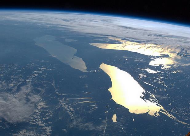 Global Warming and the Great Lakes.
 Here's an excerpt of an interview at
Yale Climate Connections: "...
Under
this particular climate scenario that we’ve experienced over the past
200 years, we can manage the water levels fairly well. But if it goes
into either very high flows or very low flows, we won’t be able to
manage it at all.” For example, with too much water in the system it
will be impossible to release enough to prevent flooding. And with too
little, there will not be enough for shipping..." (Photo credit: NASA).
8 Governors Have Chance to Protect Great Lakes Water.
The Chicago Sun Times reports.
New York Plans To Make Fighting Climate Change Good Business. Becoming more resilient in the face of a more volatile climate is an opportunity, as outlined in
The New York Times: "
A
governor wants to lead on green energy. The state’s utilities are
nervously falling in line. Young entrepreneurs are buzzing, determined
to be part of the generation that finally solves climate change.
To most ears, that might sound like California, where all those things
and more are happening. But it also describes New York. New York? The
state may not leap to mind as being in the vanguard of the green
economy. But under Gov. Andrew Cuomo,
the most populous state in the Northeast is in a close race with its
counterpart in the West in setting ambitious climate goals. And in some
ways, New York may be on the verge of pulling ahead of California..."
In Novel Tactic on Climate Change, Citizens Sue Their Governments. Proving that, once again, the lawyers will do just fine. Here's an excerpt from an explanation at
The New York Times: "...
Last
month, a federal magistrate judge in Oregon startled many legal experts
by allowing the lawsuit filed on behalf of 21 teenagers and children to
go forward, despite motions
from the Obama administration and fossil fuel companies to dismiss it;
the suit would force the government to take more aggressive action
against climate change. The ruling by the magistrate judge, Thomas M.
Coffin, now goes to Federal District Court to be accepted or rejected.
Michael B. Gerrard, the director of the Sabin Center for Climate Change Law
at Columbia Law School, called the ruling a potential landmark. “It is
the first time a federal court has suggested that government may have a
constitutional duty to combat climate change, and that individuals can
sue to enforce that right,” he said..."
Photo credit above: "
Sarah
Lorraine Thomson, a law student at the University of Waikato, has filed
a lawsuit against New Zealand’s climate change minister." Credit Mike Scott/Waikato Times, via Fairfax Media NZ.
Exxon Has a Clever Way to Capture Carbon - If It Works. At some point one of these new, emerging technologies may just work; here's a clip from
MIT Technology Review: "...
Funded by the U.S. Department of Energy, research on carbon-capturing fuel cells has been under way for several years. The FuelCell Energy technology would use what’s known as a carbonate fuel cell,
which uses carbon dioxide as one of its inputs, to capture the carbon
dioxide and concentrate it into a form that can be transported and
stored, most likely in deep underground repositories. The system would
generate additional electricity, rather than consuming it, and power
from the overall plant would cost less than electricity from plants
using earlier, amine-based solutions..."
Climate Change Driving Risk of Plant Extinction. Here's an excerpt from Climate Nexus: "
Nearly 100,000 plant species, one-fifth of the world's total, are at risk of extinction even as 2,000 new plant species are discovered every year. The State of the World’s Plants
report by Royal Botanic Gardens Kew reveals that while factors such
as land-use change and new infrastructure play a big role at present,
climate change is likely to be a bigger factor in the future in
threatening the plants’ survival..."
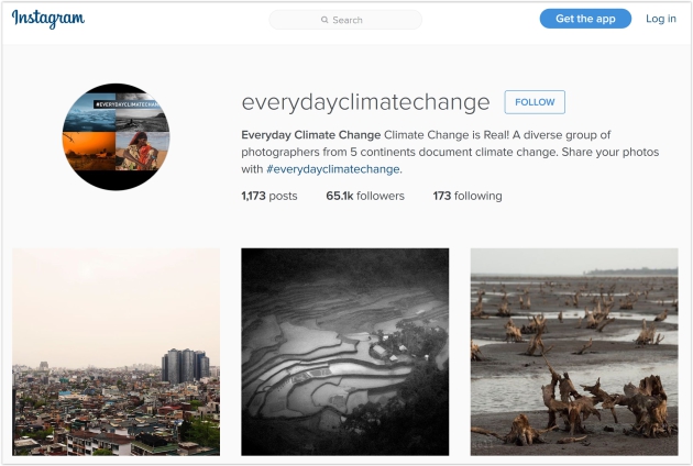
Web Site Documents Pace and Impact of Climate Change Around the World. Here's an excerpt at
Co.Exist: "...
An Instagram account, Everyday Climate Change,
documents what's happening around the world visually, with photos of
the causes and effects of global warming from every continent, including
droughts, fires, and floods. "I had been documenting the large-scale
environmental consequences in East Asia as a result of the rapid
development here," says James Whitlow Delano, the Japan-based
photographer who started the project in 2015. "The air in China had
become thick enough to cut with a knife. The deserts there are
expanding. Oil palm is leading to massive deforestation in equatorial
Southeast Asia. Larger and larger storms are hitting coastal areas in
the region, too. I felt that magnitude of the problem leading to climate
change was not being addressed..."
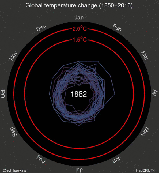
See Earth's Temperature Spiral Toward 2 Degrees Celsius. Climate Central has the story and (amazing) visualization; here's an excerpt: "
The
steady rise of Earth’s temperature as greenhouse gases accumulate in
the atmosphere and trap more and more heat is sending the planet
spiraling closer to the point where warming’s catastrophic consequences
may be all but assured. That metaphoric spiral has become a literal one
in a new graphic drawn up by Ed Hawkins,
a climate scientist at the University of Reading in the United Kingdom.
The animated graphic features a rainbow-colored record of global
temperatures spinning outward from the late 19th century to the present
as the Earth heats up..."
Visualization credit: "
Monthly global temperatures from 1850-2016." Credit: Ed Hawkins.
Raging Canadian Wildfire Points to Global Warming. CBS News has the story; here's the intro: "The wildfire that has devastated the remote Canadian town of Fort McMurray
has caused an estimated $7.3 billion in insurance-related losses, the
most from that type of disaster since 1970. Experts say the size of the
blaze, along with an increase in the number of wildfires in the U.S.,
are evidence of global warming. "This is one of the parts of the world
that has seen warmer and warmer winters and accelerated springs and
drier conditions, which are linked to increasing atmospheric greenhouse
gasses and the long-term warming that we've seen," said Glen MacDonald, a
professor of geography at University of California at Los Angeles, in .
"It's just not surprising that you would have an event like this..." (Image:
CBC News).
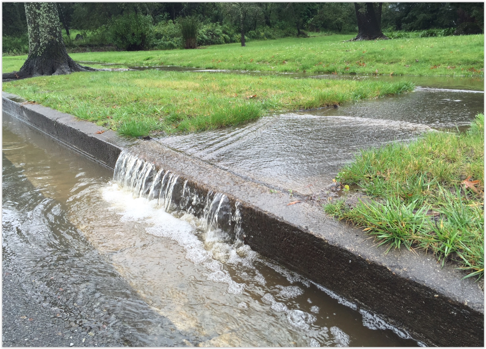
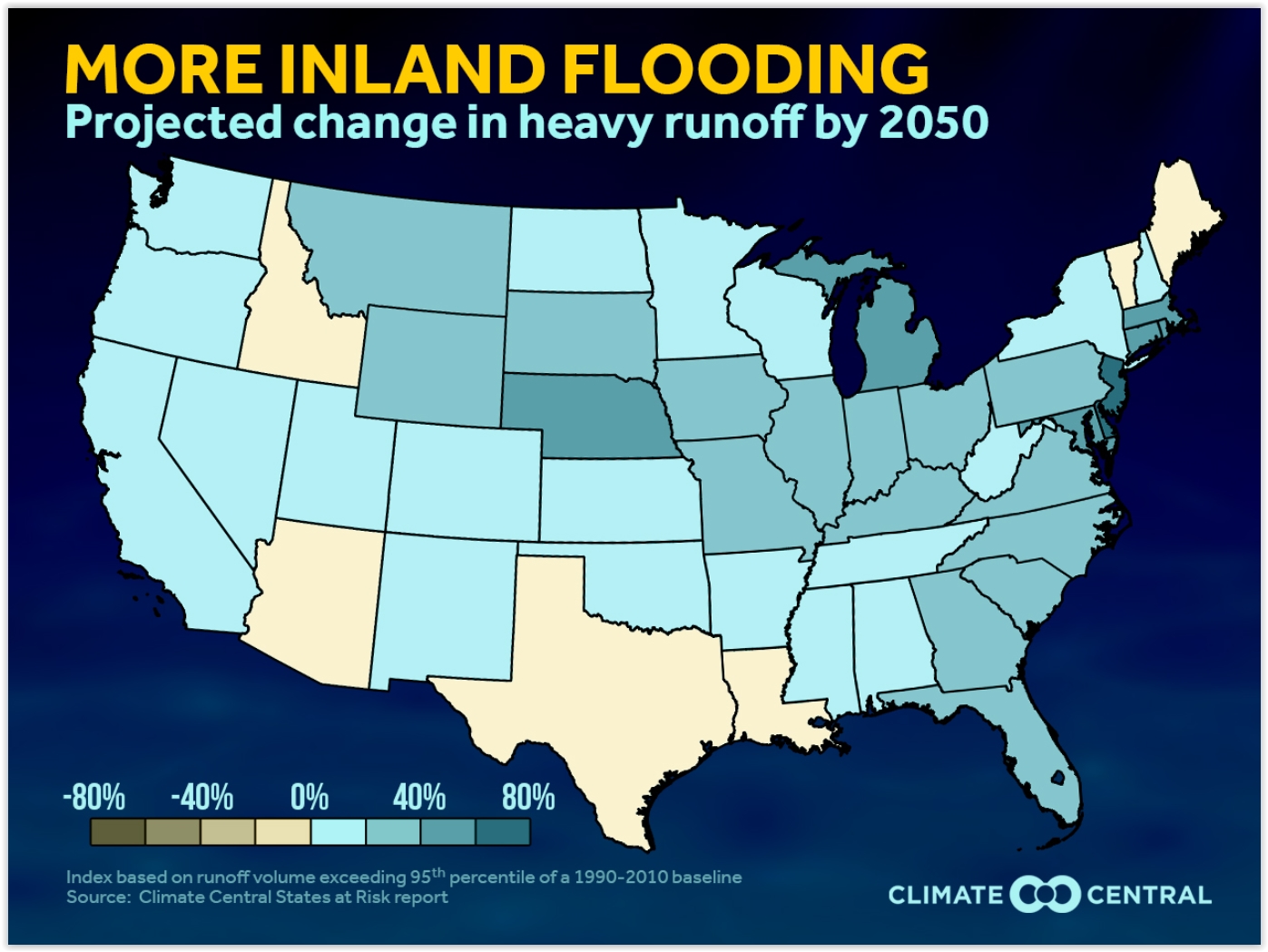 Inland Flooding Threat to Increase by 2050. WXShift
 has the analysis - here's an excerpt of a recent story: "...
The
recent flooding in the Gulf Coast states highlights the increasing
threats from heavy precipitation with climate change. Our States at Risk report examined
the intensity and duration of the heaviest runoff events for each
state. To determine the future inland flood threat, the report examined
the frequency of high water runoff that could lead to flooding threats
both currently and in the future. In this week's analysis, we examine
both the state and national projected trends for heavy runoff. Our
Flooding Severity Index is used to quantify the runoff. This index is
the average yearly sum of the daily total runoff which exceeds the 95th
percentile of a 1990-2010 baseline. Using this index incorporates both
intensity and duration of the runoff in each state (a full methodology can be found in the States at Risk report)..."
South Florida Republicans Lead Their Party from Climate Change Denial. The Charlotte Observer
has a story focused on how southern Florida is on the front line of sea
level rise associated with a warming, rising sea - here's a clip: "
Republican
Rep. Carlos Curbelo and Democratic Rep. Ted Deutch, whose South Florida
districts are already enduring increased flooding, salt water intrusion
and other effects of rising sea levels, are leading the first truly
bipartisan congressional effort to tackle climate change. Joined by Rep.
Ileana Ros-Lehtinen, a Miami Republican, they’ve formed a caucus that
uses an unusual “buddy system” in which each Democratic member must
bring along a Republican colleague willing to renounce party orthodoxy
and stop minimizing the peril – or even existence – of global warming..."
Photo credit above: "
Miami
Beach has put into action an aggressive and expensive plan to combat
the effects of sea level rise. As some streets keep flooding from recent
king tide events, the city continues rolling out its plan of attack and
will spend between $400-$500 million over the next five years doing so." Emily Michot.


No comments:
Post a Comment