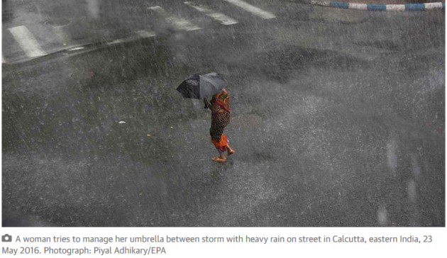
Here's a great article about the effects of climate change by Paul Douglas on The Guardian:
"Whatever happened to normal weather? Earth has always experienced epic storms, debilitating drought, and biblical floods. But lately it seems the treadmill of disruptive weather has been set to fast-forward. God’s grandiose Symphony of the Seasons, the natural ebb and flow of the atmosphere, is playing out of tune, sounding more like a talent-free second grade orchestra, with shrill horns, violins screeching off-key, cymbal crashes coming in at the wrong time. Something has changed."
Read the full article HERE:
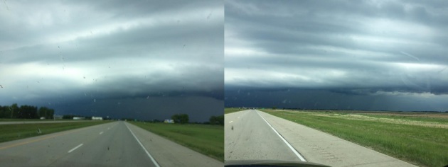
Severe Storms in the Red River Valley
Thanks to Kathy Weidner for the pictures below who was traveling east on I-94 just west of Fargo, ND Friday afternoon as they approached tornadic storms centered over the Red River Valley. Interestingly, there was a brief tornado touchdown in Clay county, MN just east of the Fargo/Moorehead area.
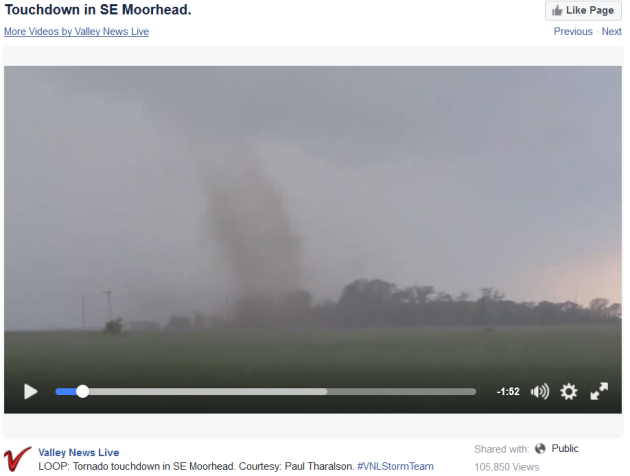
Tornado in SE Moorehead
Here is a video from the Valley News Live Facebook Page of a tornado in SE Moorehead
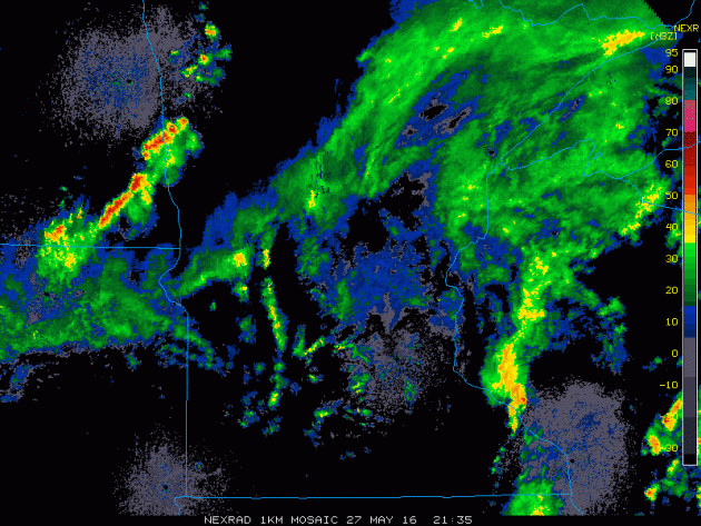
Here is the radar loop from Friday afternoon and note the cluster of storms over the Red River Valley. There were a couple of storms just east of the Fargo/Moorehead area that produced a number of funnel clouds and a brief tornado touchdown.
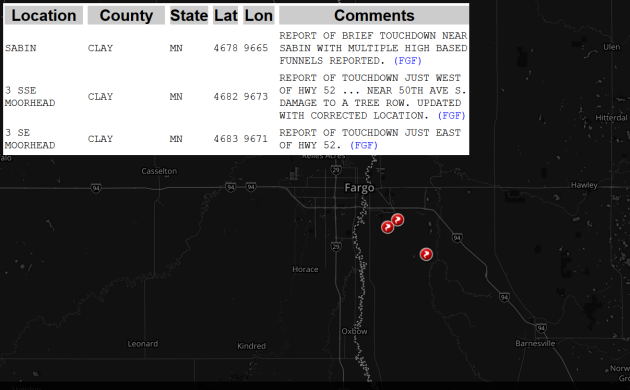
Storm Reports Friday
There
were a few tornado reports near the Fargo/Moorehead area on Friday
afternoon. The good news is that no major damage was reported other than
to a row of trees
____________________________________________________
By Todd Nelson, filling in for Douglas
Rain rain go away, come again another day. Ah, the sweet sounds of a 6 year and 4 year old singing in tandem... Are my boys just bored or are they subtly telling me that it's my fault the rain is ruining their holiday weekend so far? How do I politely tell them that their father's magical weather making powers aren't real? On second thought, maybe I can threaten rotten weather as a punishment.
While meteorologists are only messengers, we tend to be human punching bags. We're blamed when the weather is inclement, but like to take credit when the weather is flawless!
Unfortunately, we're off to a soggy start this holiday weekend. Have a plan b today as scads of showers and storms swirl through the Upper Midwest. The good news is that the weekend won't be a washout, weather improves a little tomorrow with only a few stray PM T-storms and perhaps even a little better on Memorial Day.
If your plans take you outdoors this weekend, be prepared to seek shelter if skies look threatening or you hear rumbles in the distance.
________________________________
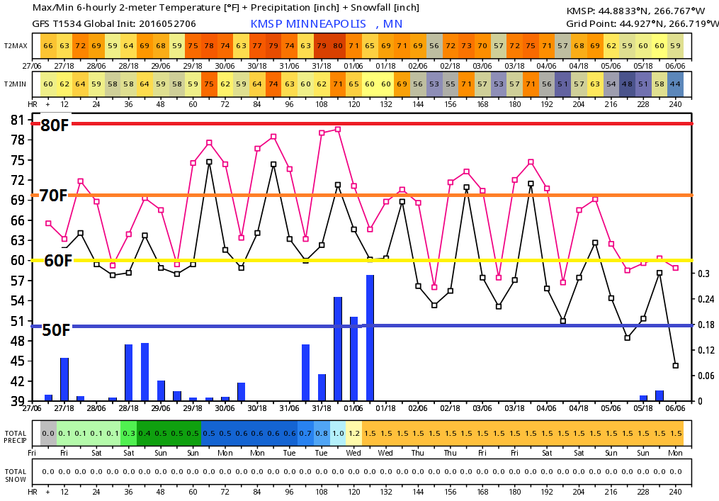
Extended Forecast
FRIDAY NIGHT: More showers and storms developing late Low: 62. Winds: ESE 5.
SATURDAY: Wettest day, numerous T-storms. High: 74. Winds: NNW 5 mph.
SATURDAY NIGHT: Wet. showers and storms early. Low: 60. Winds: W 5mph
SUNDAY: Sun and cloud mix. Stray afternoon T-storm possible. High: 79. Wind: WNW 10-15 mph.
MEMORIAL DAY MONDAY: Mild sun. Spotty PM thunder south. Wake-up: 60. High: 80. Wind: ESE 7-12 mph.
TUESDAY: Scattered PM storms with locally heavy rain. Sticky. Wake-up: 61. High: 77. Winds: SE 8-13mph.
WEDNESDAY: Still warm and unsettled. Wake-up: 60. High: 75. Winds: SSW 5-10mph
THURSDAY: Soggy start. More PM sun and breezy. Wake-up: 59. High: 71. Winds: NW 10-15mph.
FRIDAY: Bright sun, near average temps. Wake-up: 53. High: 72. Winds: N 5-10mph.
__________________________________
__________________________________
This Day in Weather History
May 27th
May 27th
1965: Late season snow falls across much of Minnesota with Duluth and Caribou reporting an inch.
___________________________________
___________________________________
Average High/Low for Minneapolis
May 27th
May 27th
Average High: 73F (Record: 98F set in 1934)
Average Low: 53F (Record: 36F set in 1965)
_____________________________________
Average Low: 53F (Record: 36F set in 1965)
_____________________________________
Sunrise/Sunset Times for Minneapolis
May 27th
May 27th
Sunrise: 5:32am
Sunset: 8:49pm
Sunset: 8:49pm
*Daylight Gained Since Yesterday: ~1mins & 37secs
*Daylight Gained Since Winter Solstice: ~6hours & 32mins
*Length of Day: ~15hours & 16mins
*Additional Light We Will Gain By Summer Solstice (June 20th): ~19mins
________________________________________
*Daylight Gained Since Winter Solstice: ~6hours & 32mins
*Length of Day: ~15hours & 16mins
*Additional Light We Will Gain By Summer Solstice (June 20th): ~19mins
________________________________________
Moon Phase for May 28th at Midnight
0.2 Days Before Last Quarter
0.2 Days Before Last Quarter

Extended Outlook
The
extended outlook through the early part of June suggests fairly warm
temperatures continuing through the end of the month, but the long range
suggests cooler than average temperatures returning as we get into the
early June with highs potentially dipping into the 60s by the first full
week of June.
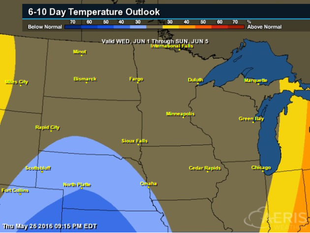
6 to 10 Day Temp Trend
According
to NOAA's CPC, the 6 to 10 day forecast suggests equal chances above
and below average temperatures, however, it does appear that cooler
temperatures look to return as we get into the early part of June.
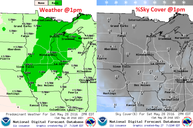
Saturday Weather Outlook
High
temperatures on Saturday look to be highly dependent on rain and cloud
cover. Although it won't be sunny, highs will still be in the 70s with
dewpoints in the 50s and 60s across the region.
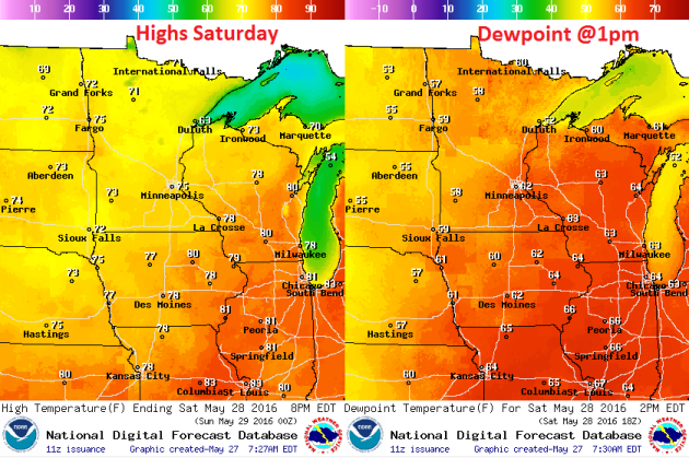
Saturday Weather Outlook
Light winds look to continue on Saturday as an area of low pressure swirls through the region.

Saturday Weather Outlook
Scattered
showers and thunderstorms look likely as we move into Saturday as an
area of low pressure slides through the region. Sky conditions look
mostly cloudy, so it won't feel quite as warm as it did on Thursday.
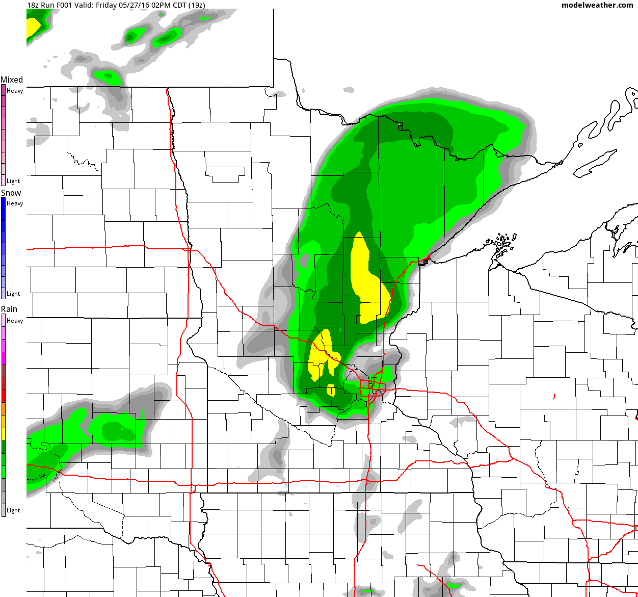
Simulated Radar
Here's
the simulated radar from midday Friday to Sunday night, which suggests
areas of heavy rainfall rotating through the region. Although the
holiday weekend doesn't look like a washout, Saturday could feature few
heavier downpours.
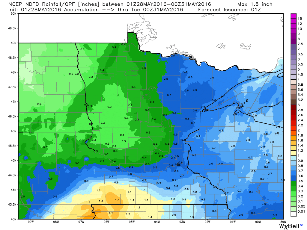
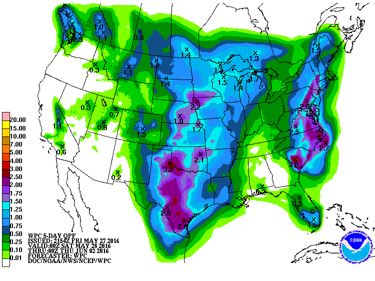
Rainfall Potential
The
MN rainfall potential through PM Monday suggests heavy rainfall
shifting east through parts of NE Minnesota and into Wisconsin. However,
it does appear that another round of heavier rain may be setting up
across far southern MN by late Monday.
______________________________________
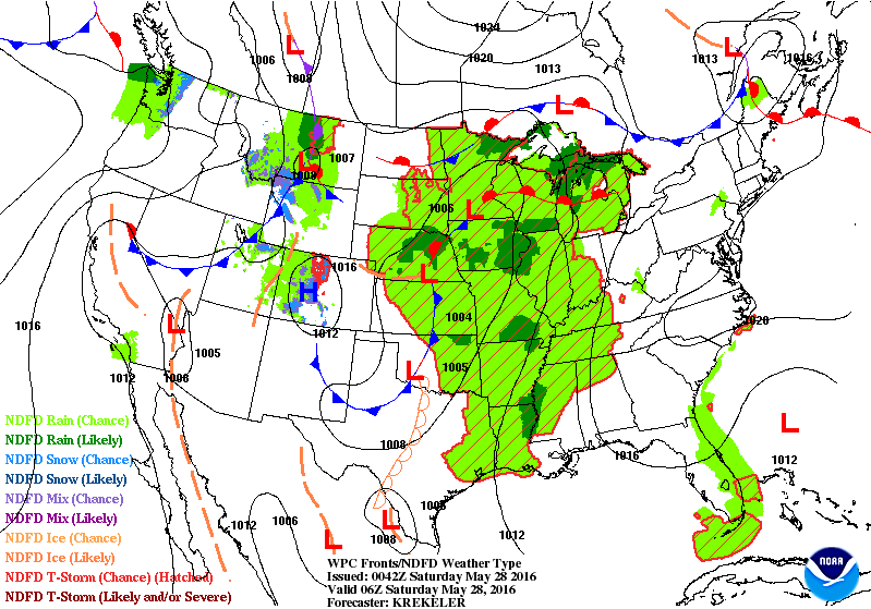
National Weather Outlook
Another
round of heavy rainfall potential looks to lift north through the Upper
Midwest on Saturday, but weather conditions look to improve as we heady
deeper into the holiday weekend with drier weather late Sunday and
Memorial Day Monday.
5 Day Rainfall
According
to NOAA's HPC, the 5 day rainfall forecast suggests heavy rainfall
potential still across the Central U.S.. Some 1" to 3"+ rainfall tallies
can't be ruled out, which may lead to flooding in areas that see heavy
rainfall in a short amount of time.
______________________________________
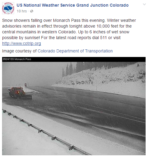
May Snow in the High Elevations
While
heavy rainfall and severe storms continue to develop in the Central
part of the country, snowfall continues across the high elevations in
the Rockies. Here was a picture from the NWS out of Grand Junction, CO
from early Friday.
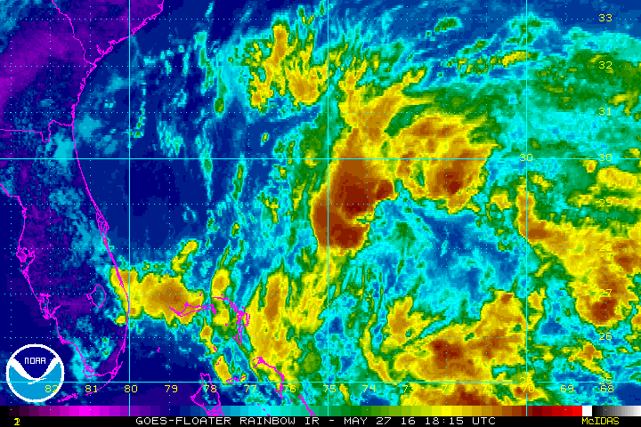
IR Satellite Loop
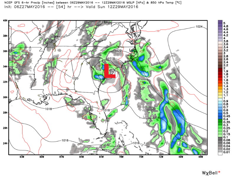
Here
was a view of the newly formed tropical system in the Atlantic basin
that developed on Friday afternoon. Note that the system is heading NW
and will likely impact the SE coast over the holiday weekend.
Tropical Depression #2
Here was the information on Tropical Depression #2 as of PM Friday.
At 800 PM EDT (0000 UTC), the center of Tropical Depression Two was
located near latitude 28.8 North, longitude 75.1 West. The
depression is moving toward the west-northwest near 13 mph (20
km/h), and this general motion is expected to continue for the next
24 hours.  A reduction in forward speed is expected by Saturday
night as the system nears the coast.

Maximum sustained winds are near 35 mph (55 km/h) with higher gusts.
Some strengthening is forecast during the next 48 hours, and the
depression is expected to become a tropical storm later tonight or
on Saturday.
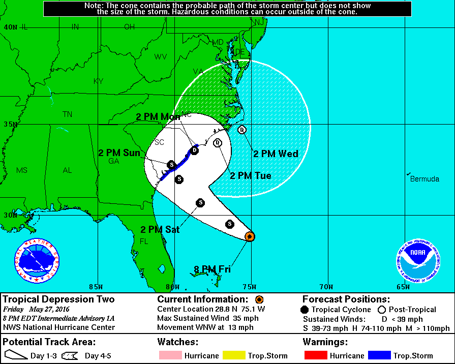
Here is a look at the tropical system as it forecast to slide into South Carolina over the weekend. the forecast actually calls for this to develop into tropical storm Bonnie this weekend.
 __________________________________
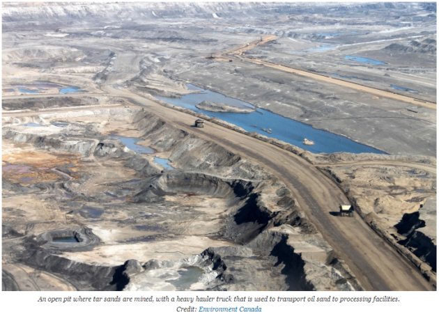
"New Tar Sands Impact on Climate, Air Quality Found"
"In one of the first studies of its kind, scientists have found that tar sands production in Canada is one of North America’s largest sources of secondary organic aerosols — air pollutants that affect the climate, cloud formation and public health. The study, published Wednesday in the journal Nature, showed that the production of tar sands and other heavy oil — thick, highly viscous crude oil that is difficult to produce — are a major source of aerosols, a component of fine particle air pollution, which can affect regional weather patterns and increase the risk of lung and heart disease."
Read more from Climate Central HERE:
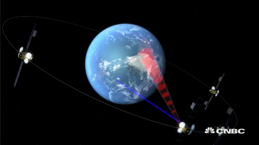
"How satellites are helping to fight climate change"
They may be many, many miles up in the air, but satellites have a vital role to play when it comes to analysing our planet and its climate. In the U.S., for example, NASA says it has over a dozen "Earth science" spacecraft and instruments in orbit, and is conducting research on everything from solar activity to rising sea levels, air pollution and "changes in sea ice and land ice." The European Space Agency (ESA), based in Paris, is also keen to stress just how important the relationship between space and our climate is. "The data we get from space in influencing people about climate change is very, very important," Philip Haines, the European Space Agency's head of telecom business development, told CNBC's Sustainable Energy. The ESA says that climate change is arguably "the greatest challenge facing mankind in the 21st century," and for Haines, the data gathered from up in the heavens is invaluable.
Read more from CNBC HERE:
Thanks for checking in and have a wonderful holiday weekend ahead! Don't forget to follow me on Twitter @TNelsonWX

No comments:
Post a Comment