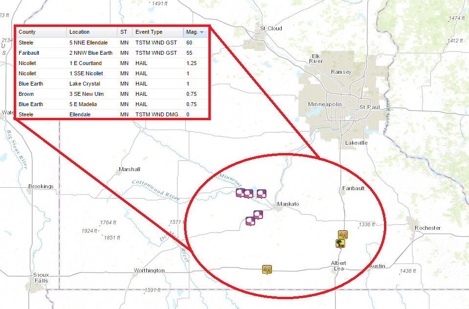
A fairly significant line of strong to severe storms rolled across southern Minnesota Wednesday night/early Thursday morning. Heavy rain and loud thunder clipped the southern metro, but there were a few severe storm reports in south-central Minnesota.
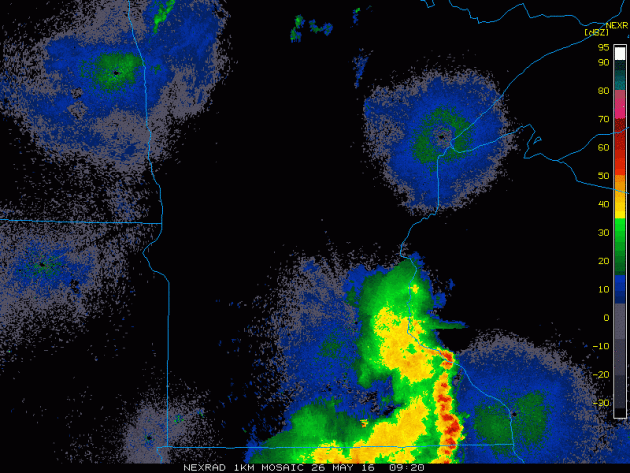
Some of the severe storm reports from PM Wednesday to AM Thursday shows that 1.25" diameter hail fell in Courtland as well as thunderstorm wind damage in Blue Earth and Ellendale.
_____________________________________
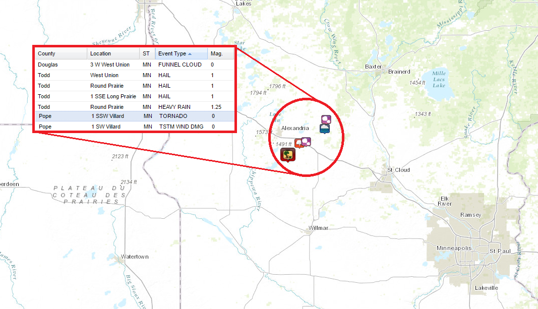
Tornado on Wednesday?
Going back to Wednesday. An isolated storm developed in the afternoon near Villard, MN and was actually responsible for spawning a tornado. There were reports of: BOATS FLIPPED ... SHED DAMAGED AND SHINGLES OFF ROOFS NEAR AMELIA LAKE.
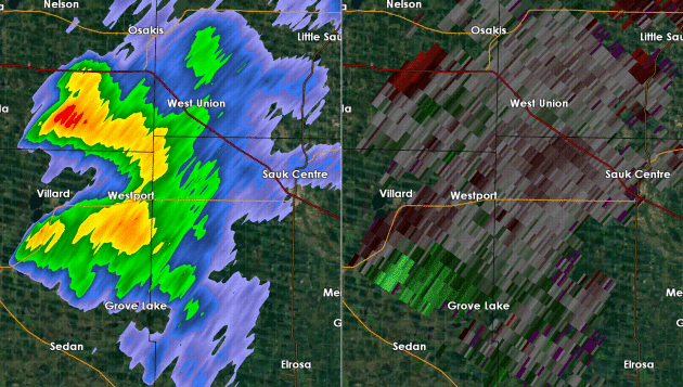
Radar From Tornadic Storm Wednesday Afternoon
This is what the radar looked like as the storm passed over the Lake Amelia area. Note the radar on the left shows a fairly small "hook" near Villard and Amelia Lake, while the screen on the right shows the inbound/outbound winds and a fairly tight couplet (red and green close together). This would indicate tight rotation within the storm.
_______________________________
Thundery Lumps in our Tropical Holiday Stew
By Paul Douglas
By Paul Douglas
After
listening to people complain about the cold for the better part of 5
months I'm in no mood to complain about a little warmth and humidity.
Make my sauna medium-rare, please.
I'm
trying to keep a sense of perspective. We're not tracking the tornadoes
that have carved up Kansas and Oklahoma in recent days. We're not stuck
on a barrier island off the Carolina coast, wondering if a clump of
thunderstorms over the Bahamas will strengthen into Tropical Storm
Bonnie by Sunday. Minnesota's weather won't be as awe-inspiring as last weekend, but it can always be worse.
Studying the models I still think Sunday and Monday
will be the best outdoor-days of the holiday weekend, with enough hazy
sun for 80 degrees. Showers and T-storms will be heaviest and most
widespread today and Saturday
as a weak, slow-moving trough of low pressure pushes across the Plains.
No all-day washouts, but you would be well-advised to have a Plan B
later Friday and Saturday.
No
heatwaves brewing, in fact a a push of cool Canadian air may keep us in
the 60s by late next week. Free A/C courtesy of Manitoba.
________________________________
Extended Forecast
THURSDAY NIGHT: Increasing clouds with a showers and storms late. Low: 64. Winds: WSW 5.
FRIDAY: More T-storms with locally heavy rain. High: 80. Wind: S 10-15 mph.
FRIDAY NIGHT: Showers and storms. Low: 63. Winds: SSE 5.
SATURDAY: Wettest day, numerous T-storms. High: 76. Wind: S 10-15 mph.
SUNDAY: Lake worth. Drier with more sun, another T-storm. Wake-up: 63. High: 81. Wind: W 10-15 mph.
MEMORIAL DAY MONDAY: Peeks of sun. Late day thunder risk. Wake-up: 64. High: 83. Wind: E 7-12 mph.
TUESDAY: Shocker: more t-storms. Sticky. Wake-up: 65. High: 78. Winds: SE 8-13mph.
WEDNESDAY: More T-storms, some strong? Wake-up: 63. High: 77. Winds: SE 10-20mphTHURSDAY: Partly sunny, cooler and less wind. Wake-up: 58. High: 70. Winds: W 10-15mph.
____________________________
This Day in Weather History
May 27th
May 27th
1930: The Great Empire Builder Tornado occurs. A direct hit derails a famous train in Norman County.
________________________________
Average High/Low for Minneapolis
May 27th
May 27th
Average High: 73F (Record: 95F set in 1969)
Average Low: 52F (Record: 34F set in 1907)
_________________________________
Average Low: 52F (Record: 34F set in 1907)
_________________________________
Sunrise/Sunset Times for Minneapolis
May 27th
May 27th
Sunrise: 5:33am
Sunset: 8:47pm
Sunset: 8:47pm
*Daylight Gained Since Yesterday: ~1min & 40secs
*Daylight Gain Since Winter Solstice: ~6hours & 30mins
*Daylight Gain Since Winter Solstice: ~6hours & 30mins
*Length of Day: ~15hours & 16mins
___________________________________
___________________________________
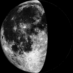
Moon Phase for May 27th at Midnight
1.2 Days Before Last Quarter
1.2 Days Before Last Quarter
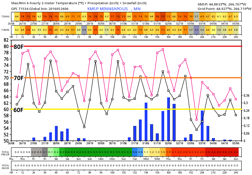
Extended Forecast
Good
news warm weather fans! Warmish weather looks to continue throughout
much of the rest of May with highs in the upper 70s and 80s. These warm
temps will also be accompanied by muggier dewpoints, so by Minnesota
standards, this might be a little too warm... Note the slightly larger
cool down as we head into the early part of June with highs dipping into
the 70s.
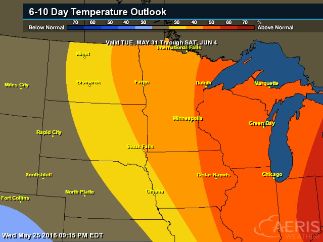
6 to 10 Day Temperature Outlook
While
we are getting indications of a slight cool down into the early part of
June, NOAA's CPC 6 to 10 day temperature outlook is still suggesting a
fairly decent chance of warmer than average temps across the Upper
Midwest/Great Lakes Region from May 31 to June 4.
_______________________________________
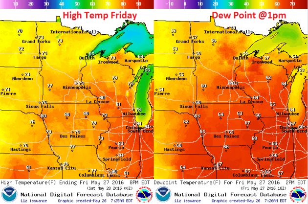
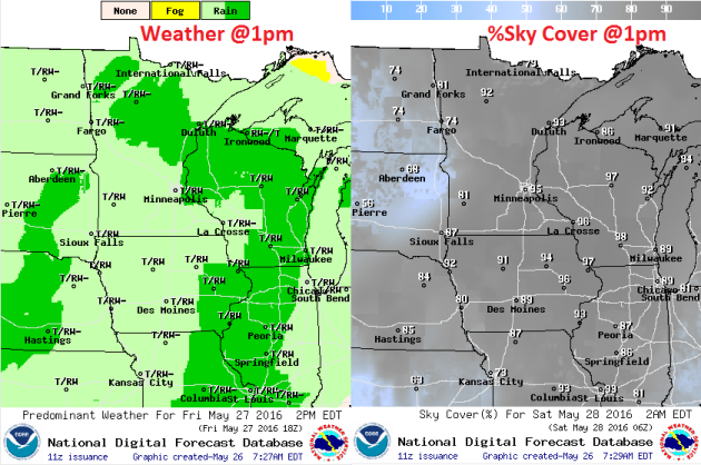
Friday Weather Outlook
Warmer
than average temperatures continue on Friday with highs in the 70s
across the state. Temps will be running about 5 degrees above average or
so with dewpoints in the 50s and 60s, which means that it will feel
like another summer day. Note that the first day of Meteorological
Summer doesn't start until June 1st, while the first day of astronomical
summer doesn't start until June 20th.
Friday Weather Outlook
Friday
appears to be another unsettled day across the Upper Midwest with
spotty showers and storms rolling through the state. There doesn't
appear to be as much sunshine as there was on Thursday either. However,
even with cloudier skies and rain chances, it'll feel lukewarm and
muggy.
Friday Weather Outlook
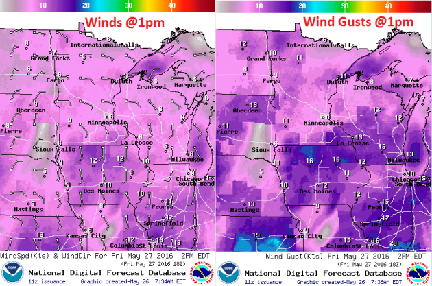
As
our next impulse of energy rolls into the region with scattered showers
and storm, winds will be on the increase. Note that winds on Friday
will be out of the east as the low approaches from the southwest.
Overall wind speeds don't look like a big issue, but there could be a
few gusts that approaches 15mph across parts of the state at times.
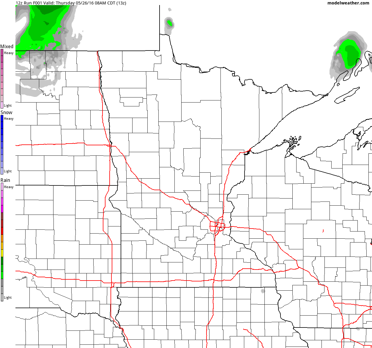
Simulated Radar
The
simulate radar below from AM Thursday to 7pm Saturday shows mostly
quiet weather conditions from earlier Thursday to a more unsettled
outlook PM Thursday into Friday and Saturday. Keep in mind that there
doesn't appear to be any widespread severe storms, but there could be a
few isolated strong ones with heavy rainfall chances.
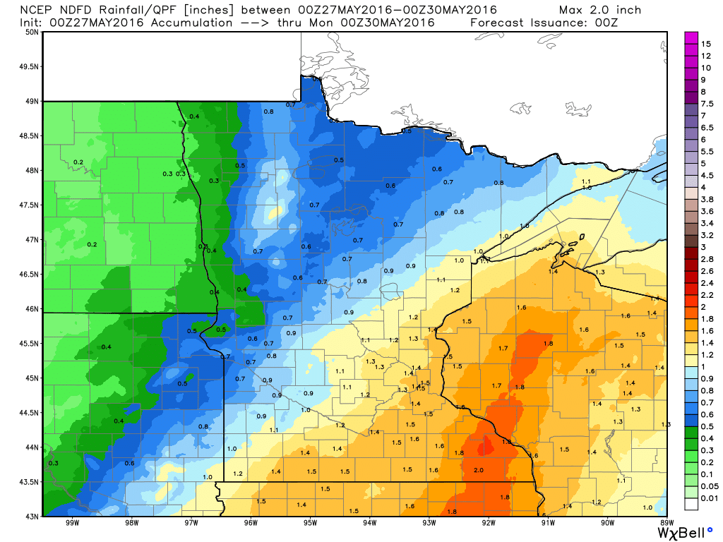
Precipitation Potential
The
rainfall potential shows a fairly good soaking across much of Minnesota
and Wisconsin through 7pm Sunday. This will come by of numerous swarms
of showers and storms from PM Thursday to Saturday
_____________________________________
National Weather Outlook
As
another impulse of energy rolls northeast through the middle part of
the country through PM Saturday, widespread showers and storms will
produce strong to severe storms and areas of heavy rainfall. While the
best chance of severe weather with this particular storm system was on
Thursday, there will still be a decent chance of strong to severe storms
on Friday and Saturday in the Central U.S... There will also be areas
of potential flooding that develop with this system too.
Severe Threat Friday
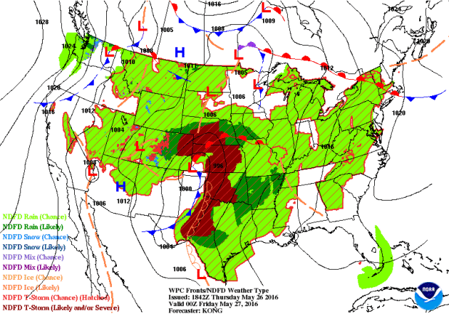
...SUMMARY...
   SEVERE THUNDERSTORMS WITH ISOLATED LARGE HAIL AND WIND DAMAGE WILL
   BE POSSIBLE OVER PORTIONS OF EASTERN TEXAS INTO EASTERN OKLAHOMA ON
   FRIDAY...WITH ISOLATED SEVERE STORMS FROM WESTERN OKLAHOMA INTO
   CENTRAL KANSAS. MARGINALLY SEVERE STORMS MAY ALSO OCCUR FROM CENTRAL
   NEW YORK INTO WESTERN NEW ENGLAND.

   ...SYNOPSIS...
   A SHORTWAVE TROUGH WITH 40-50 KT MIDLEVEL SPEED MAX WILL EJECT NEWD
   FROM THE SRN PLAINS ON FRI INTO THE MID/UPPER MS VALLEY BY SAT
   MORNING WITH A QUASI-STATIONARY SFC TROUGH EXTENDING FROM ERN NEB TO
   A CNTRL KS LOW AND WITH A DRYLINE EXTENDING SWD INTO WRN TX. AN
   EXPANSIVE AREA OF MID TO UPPER 60S F DEWPOINTS WILL EXIST ACROSS THE
   CNTRL AND SRN PLAINS WITH AMPLE INSTABILITY TO SUPPORT STRONG TO
   SEVERE STORMS.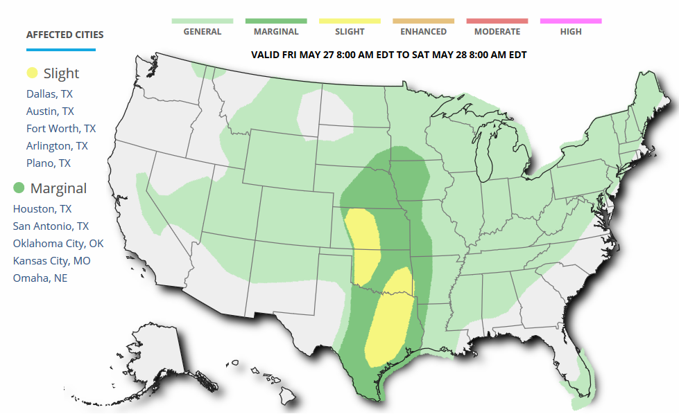
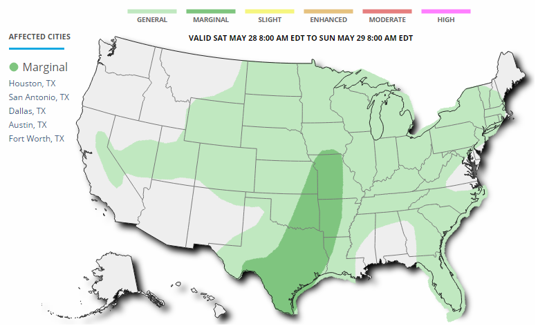
Severe Threat Saturday
...SUMMARY...
   MARGINALLY SEVERE THUNDERSTORMS WITH HAIL AND STRONG WIND GUSTS WILL
   BE POSSIBLE ACROSS THE SOUTHERN PLAINS...ARKLATEX...OZARKS AND LOWER
   MISSOURI VALLEY.
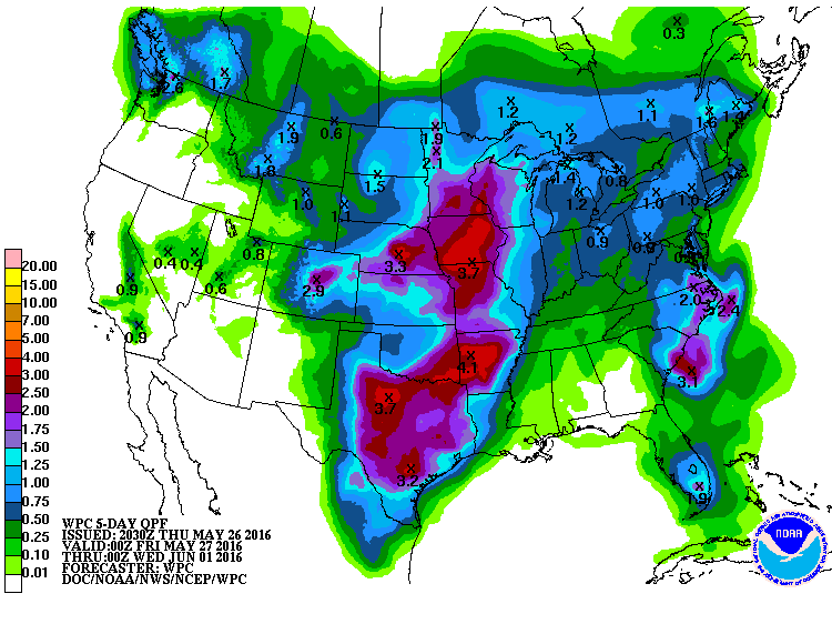
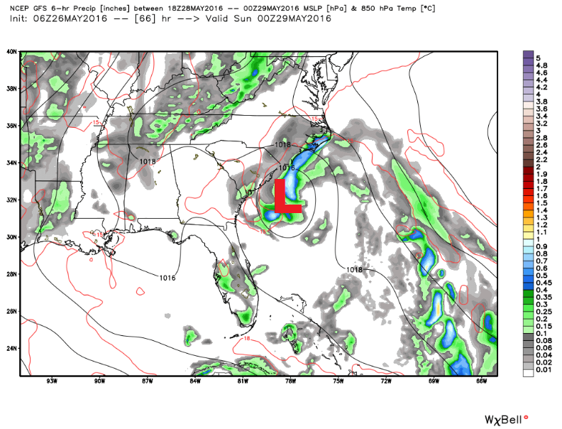
Rainfall Potential
Widespread showers and storms will continue across the central part of the country over the next several days with chance of strong to severe storms and heavy rainfall. Take a look at NOAA's WPC 5 day rainfall forecast through AM Tuesday. Note the widespread 2" to 4"+ from parts of the Upper Midwest to the Coastal Bend of Texas. Areas of flooding can't be ruled out as heavy rainfall from convective storms continue into the weekend.
_________________________________
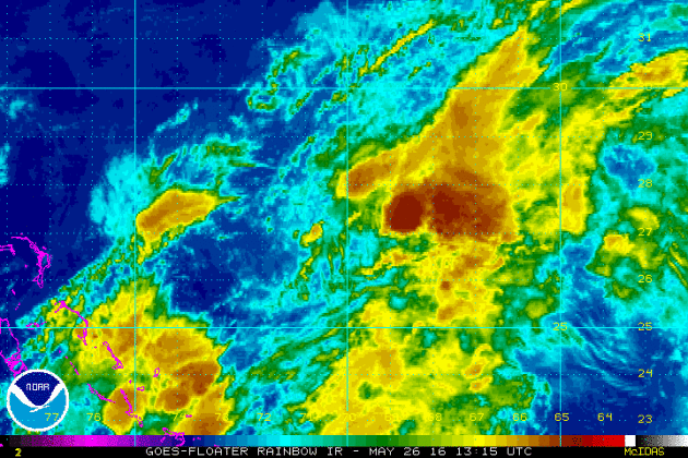
Invest 91L
Take a look at the blob of clouds seen on the IR satellite loop below. While it may not look like much at first, this batch of clouds has a pretty good chance of tropical development within the next couple/few days. Interestingly, this mass is moving slowly NW toward the Lower 48 and could impact parts of the Southeast and Mid-Atlantic states over the Memorial Weekend Holiday.
Tropical Development?
Interestingly, this particular area of low pressure has caught the attention of the National Hurricane Center. They are deeming this particular system as having a high chance of tropical development within the next 5 days! Note that the system seems to be tracking NW toward Georgia and South Carolina. Stay tuned...
1. Shower activity associated with the low pressure area located
between Bermuda and the Bahamas has become somewhat better
organized since yesterday, and the circulation of the low has become
a little better defined.  Environmental conditions are expected to
be generally conducive for a tropical or subtropical cyclone to form
on Friday or Saturday while this system moves west-northwestward or
northwestward toward the southeastern United States coast.  All
interests along the southeast coast from Georgia through North
Carolina should monitor the progress of this low.  An Air Force
Reserve Hurricane Hunter aircraft is scheduled to investigate the
low on Friday afternoon.  The next Special Tropical Weather Outlook
on this disturbance will be issued by 8 AM EDT Friday morning. For
additional information on this system, see High Seas Forecasts
issued by the National Weather Service.
* Formation chance through 48 hours...high...80 percent
* Formation chance through 5 days...high...80 percent

High Seas Forecasts issued by the National Weather Service can be
found under AWIPS Header NFDHSFAT1 and WMO Header FZNT01 KWBC.

Forecaster Kimberlain
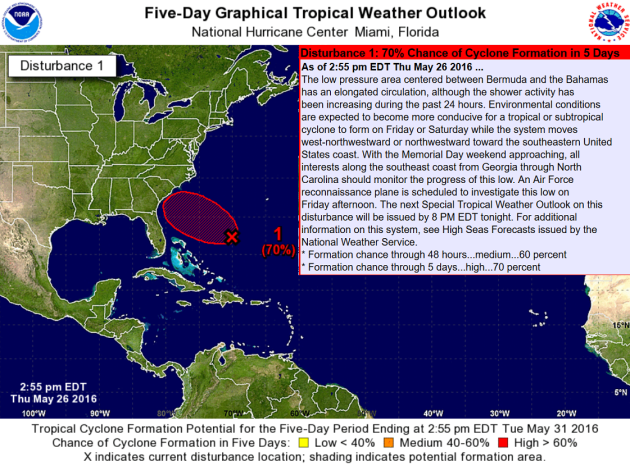
Coastal Storm This Weekend
The extended forecast shows that particular area of low pressure snuggling up to the Coast of South Carolina by 7pm Saturday. This would potentially bring heavy rainfall, gusty winds and heavy surf along the coast just in time for the upcoming Memorial Weekend Holiday.
_______________________________________
Space weather is a hidden risk to Arctic cruises, and it could be a significant one
Here's an interesting story from the WashingtonPost regarding Space Weather and how it could impact Arctic cruises.
“Space weather” refers to huge eruptions of radiation and plasma from the surface of the sun. The eruptions can cause geomagnetic storms here on Earth that spark brilliant auroras near the poles, but they can affect or even bring down the electrical grid, radio communications, GPS and other satellite services. The storms can last days to weeks, depending on its strength. And to make matters even more precarious, space weather forecasting is about as mature in 2016 as weather forecasting was in 1930. So as the Serenity journeys through the Arctic on a route that no other cruise ship has yet succeeded in sailing, a strong geomagnetic storm could bring down its GPS and communication with the rest of the world. High wind, heavy seas and, most menacingly, sea ice could necessitate a rescue, and communications and positioning are necessities in bringing emergency responders."

____________________________________________
Thanks for checking in and have a great weekend ahead! Don't forget to follow me on Twitter @TNelsonWX

No comments:
Post a Comment