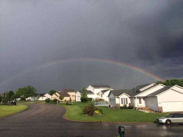
Sunday Rainbows
Sunday
afternoon featured a few showers and storms across the southern half of
the state. Here was a picture as a rainbow developed in the wake of a
heavy downpour on the NW side of the metro.
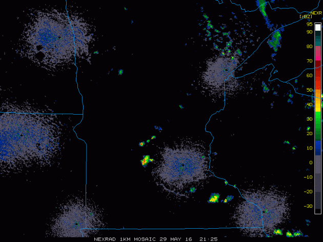
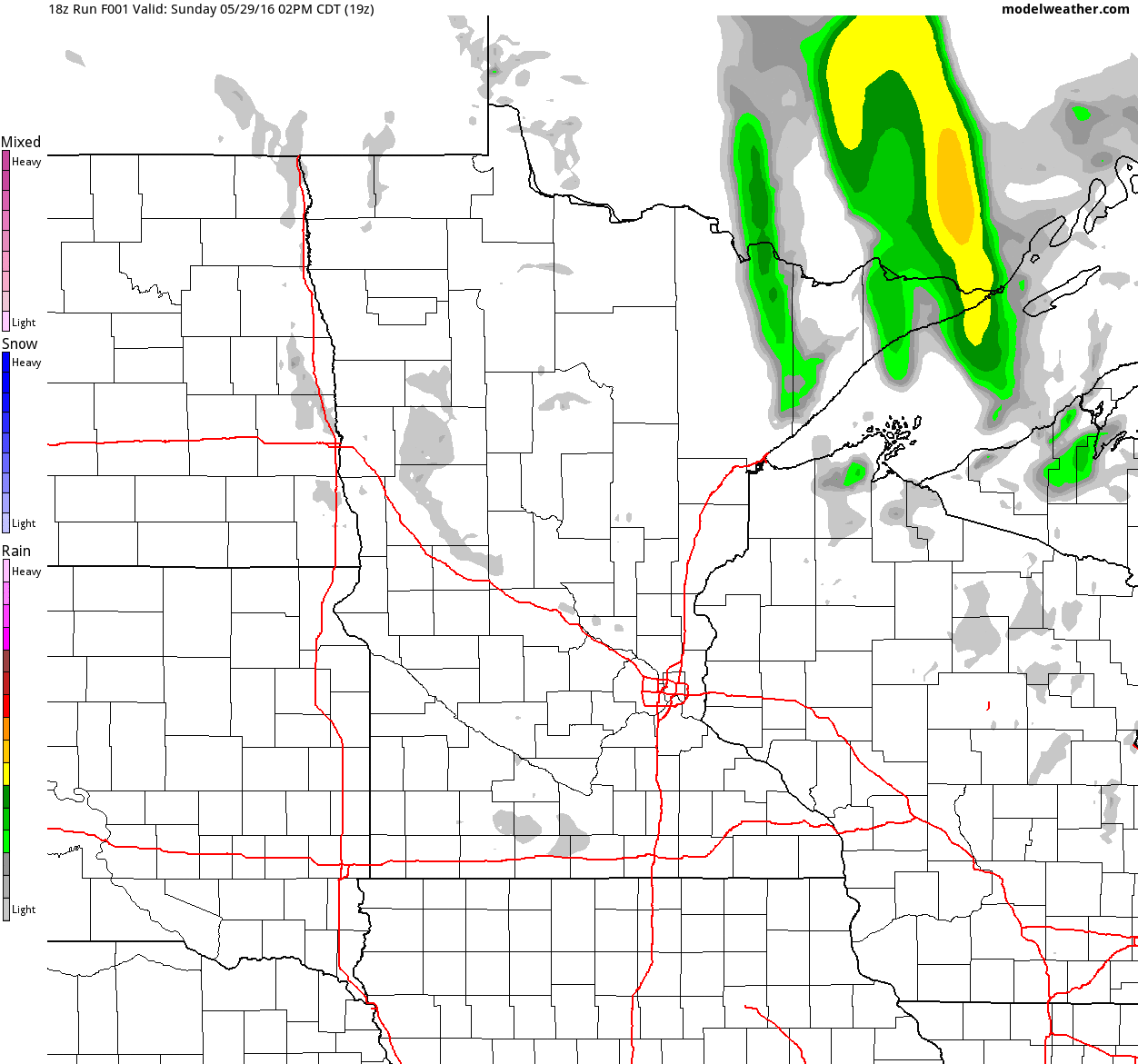
This
is what the radar look like late Sunday afternoon/early evening as a
few storms popped up and pushed through parts of Central MN.
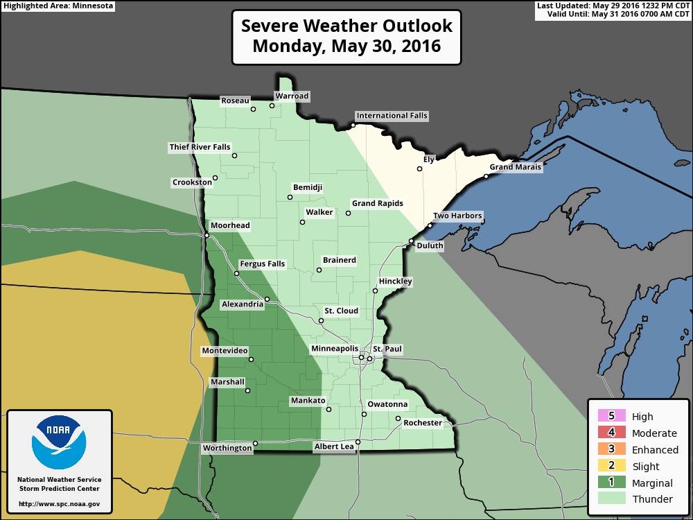
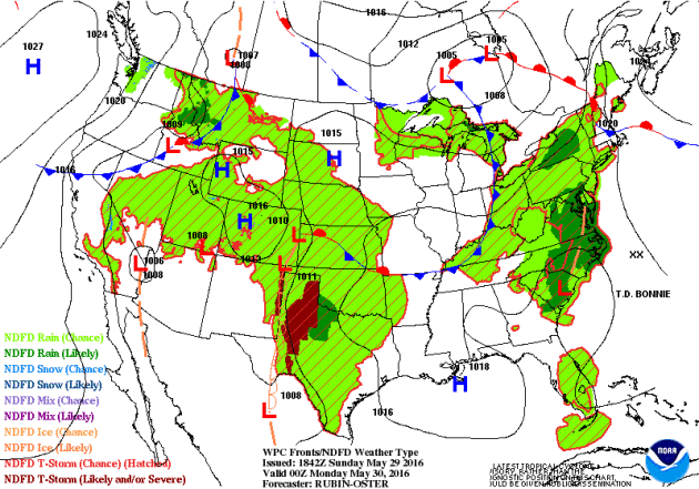
Severe Threat Monday
...SUMMARY...
   ISOLATED SEVERE THUNDERSTORMS ARE POSSIBLE ACROSS PARTS OF THE
   NORTHERN GREAT PLAINS SOUTHWARD INTO THE CENTRAL AND SOUTHERN HIGH
   PLAINS MONDAY AFTERNOON AND EVENING.  ISOLATED STRONG TO PERHAPS
   LOCALLY SEVERE STORMS MAY DEVELOP OVER PORTIONS OF NEW ENGLAND
   DURING THE AFTERNOON. LOCALLY DAMAGING WIND GUSTS AND LARGE HAIL
   WILL BE THE MAIN THREATS.

   ...SYNOPSIS...
   COMPLEX SPLIT FLOW REGIME WILL PERSIST MONDAY. IN THE NRN STREAM A
   SHORTWAVE TROUGH NOW OVER THE PACIFIC NW IS FORECAST TO AMPLIFY AS
   IT MOVES INTO THE NRN HIGH PLAINS DURING THE AFTERNOON. THE NEGATIVE
   TILT TROUGH CURRENTLY OVER THE GREAT LAKES WILL DEAMPLIFY AS IT
   CRESTS UPPER RIDGE OVER THE NERN STATES. IN THE SRN STREAM THE
   CUTOFF UPPER LOW OVER THE SWRN U.S. WILL DRIFT VERY SLOWLY EWD
   ACROSS AZ...BUT POTENTIAL EXISTS FOR WEAKER DOWNSTREAM IMPULSES TO
   MOVE INTO THE SRN PLAINS.
   A SFC LOW WILL EVOLVE OVER THE NRN HIGH PLAINS IN ASSOCIATION WITH
   THE APPROACHING SHORTWAVE TROUGH. BY MID-DAY A WARM FRONT WILL
   EXTEND FROM THE LOW OVER WRN SD EWD INTO THE UPPER MS VALLEY. A COLD
   FRONT WILL ADVANCE SEWD THROUGH ERN MT AND EVENTUALLY MERGE WITH THE
   SFC TROUGH OVER THE NRN HIGH PLAINS.  THE COLD FRONT WILL ACCOMPANY
   THE PROGRESSIVE NRN-STREAM SHORTWAVE TROUGH THROUGH THE DAKOTAS AND
   NEB MONDAY EVENING AND OVERNIGHT. FARTHER SOUTH THE DRYLINE WILL
   PERSIST OVER THE SRN AND CNTRL HIGH PLAINS.
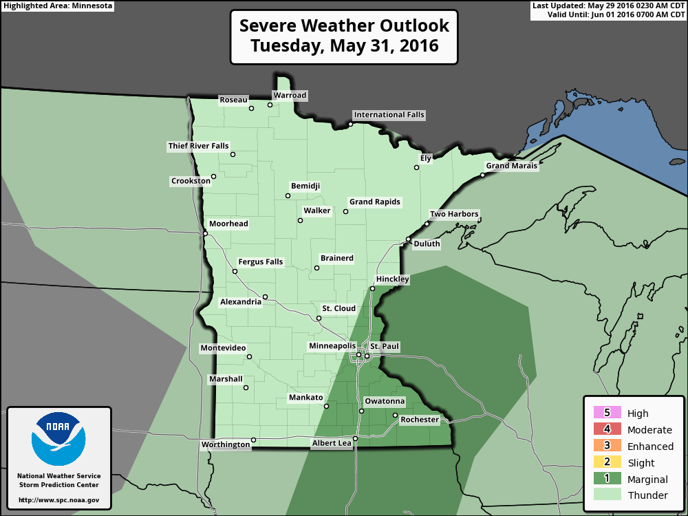
Severe Threat Tuesday
...SUMMARY...
   ISOLATED STRONG TO SEVERE THUNDERSTORMS ARE POSSIBLE TUESDAY
   AFTERNOON AND EARLY EVENING FROM THE UPPER MISSISSIPPI VALLEY
   SOUTHWESTWARD INTO THE SOUTHERN GREAT PLAINS.  LOCALIZED STRONG
   THUNDERSTORMS ARE POSSIBLE NEAR THE NORTHEASTERN GULF COAST AND
   NORTH FLORIDA DURING THE AFTERNOON.
Simulated Radar
Here's
the simulated radar from PM Sunday to Tuesday night. Note that a few
lingering showers will be possible on Sunday. At this Point, Memorial
Day Monday looks good for the most part, but showers and storms arrive
late Monday night into Tuesday with locally heavy downpours. There may
also be an isolated strong storm or two as the line moves through...
stay tuned.
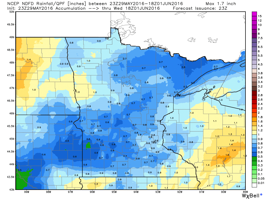
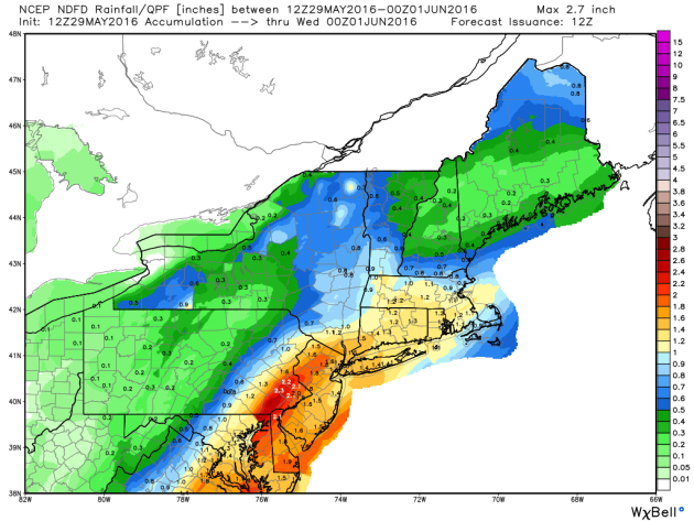
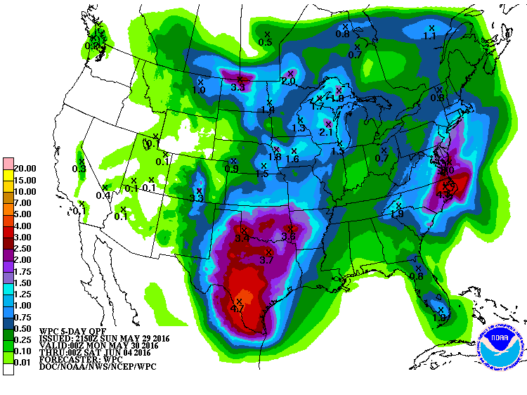
Rainfall Potential
The
somewhat soggy weather will slowly push east on Sunday with a few
lingering light showers across the region (mainly east). The next best
chance of rain arrives late Monday night into Tuesday with some heavier
downpour potential. The image below suggests rainfall tallies through
midday Wednesday with some some near 1"+ tallies across MN & WI.
______________________________________________
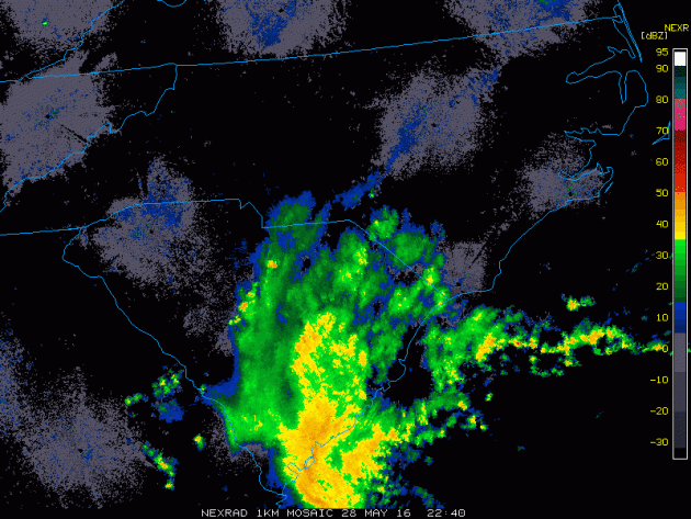
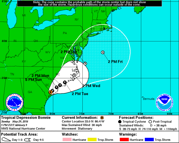
Tropical Depression Bonnie: Radar Earlier Saturday During Tropical Storm Status
The radar loop below from PM Saturday showed bands of heavy rainfall pushing into South Carolina when Tropical
Depression Bonnie was at Tropical Storm Strength. Gusty squalls will
continue to bring strong winds and heavy pockets of rain to areas along
the Coast as the weekend continues. The other big concern will be a
strong rip current potential.
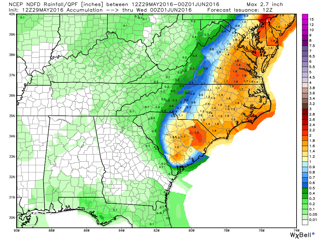
Rainfall Potential
Here's
the rainfall potential through PM Tuesday, which suggests widespread 1"
to 2" amounts from the Carolinas to parts of the Northeast. Heavy
rainfall could lead to flood concerns along the coast and for some
inland locations.
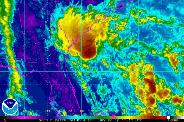
IR Satellite
The
IR satellite from PM Saturday when Bonnie was at Tropical Storm
strength. The satellite loop showed a fairly large blob of intense
clouds nearing the SE Coast. This blob of moisture brought areas of
heavy rainfall, gusty winds and RIP currents along the coast through
during the first part of the holiday weekend.
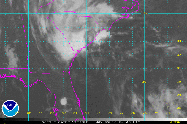
This
was the visible satellite view of Bonnie on Sunday. The IR satellite
turns to visible satellite revealing more definition in the clouds as
the center of circulation was just about to make landfall along the
coast of South Carolina
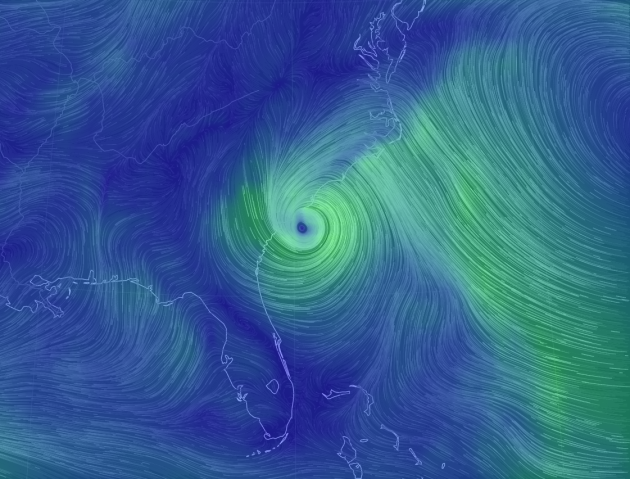
Wind Circulation From Early Sunday...
Wind
circulation from early Sunday showed a very evident cyclonic wind field
surrounding Bonnie. Note here that the center of circulation was
sitting just off the coast of South Carolina.
Projected Path
Here's
an interesting produce that suggests potential wind speeds over time.
Note that a few models keep this particular storm into Tropical Storm
strength over the next few days, while most models bring it back down
to Tropical Depression status.
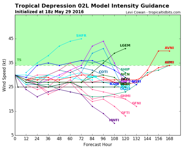
Model Paths
The
model path for this particular storm shows a pretty evident NE track
after the system tracks into South Carolina. This system will likely
pick up speed as we head into next week as it start to encounter
stronger upper level winds, which may help to minimize the heavy
rainfall threat as some of the moisture lifts into parts of the NE.

____________________________________
Sunny Memorial Day - Thundery Downpours Overnight
By Todd Nelson
By Todd Nelson
Ahh,
now this is more like it! Saturday's cloudy, wet weather was for the
birds; ducks, in fact. After a not too shabby Sunday, I am happy to
report that today will be THE nicest day of the holiday weekend.
Reminiscent of late June, we reach the pinnacle today with bright sun and highs around 80 degrees. I guess this is what they call Chamber of Commerce weather. Even the complaint department has the day off!
Whether it's heading to the lake or mowing the neglected hay field in your back yard due to several days of inclement weather last week, today's a winner 3 weeks from the Summer Solstice (June 20th).
A fairly vigorous area of low pressure looks to spin up swarms of showers and storms late Monday with thundery downpours possible in spots through Tuesday. Cool exhaust on the backside of this storm brings us into the 60s for highs by the end of the week. Overnight lows will dip into the 40s with a few 30s possible up north. No worries though, widespread frost and freeze is not likely.
Keep calm and garden on!
__________________________
Extended Forecast
SUNDAY NIGHT: A few showers early, then turning mostly clear. Low: 58. Winds: WNW 5mph
MEMORIAL DAY MONDAY: Best day of the holiday weekend. Clouds thicken late. High: 81. Wind: SSE 5mph.
MONDAY NIGHT: Scattered showers and storms develop with locally heavy rainfall. Low: 62. Winds: SSE 5mph
TUESDAY: Scattered storms with locally heavy rain. A little muggy. High: 77. Winds: S 5-10mph.
WEDNESDAY: Breezy. Stray PM rumble. Wake-up: 58. High: 69. Winds: W 5-10mph
THURSDAY: More sun, refreshing breeze. Wake-up: 52. High: 69. Winds: WNW 5-10mph.
FRIDAY: Dry start. Scattered PM T-storms. Wake-up: 55. High: 76. Winds: SE 5mph.
SATURDAY: Lingering storm early, better later. Wake-up: 60. High: 77. Winds: SW 5mph.
SUNDAY: Mostly sunny. Nice June Day. Wake-up: 60. High: 78.
________________________
This Day in Weather History________________________
May 30th
1998: A devastating line of storms hits east central Minnesota. 100 mph winds rip through Scott and Dakota County. Over 500 homes are damaged in Washington County. 15,000 trees are lost in the Twin Cities metro area, and 500,000 people lose power in Minneapolis.
1985: A tornado hits Lakefield, and the Twin Cities report 67 mph winds.
_________________________
Average High/Low for Minneapolis
May 30th
Average High: 74F (Record: 98F set in 1934)
Average Low: 53F (Record: 37F set in 1947)
__________________________
Sunrise/Sunset Times for Minneapolis
May 30th
Sunrise: 5:31am
Sunset: 8:50pm
*Daylight Gained Since Yesterday: ~1min & 30secs
*Daylight Gain Since Winter Solstice: ~6hours & 34 mins
*Length of Daylight: ~15hours & 21mins
___________________________
Moon Phase for May 30th at Midnight
1.8 Days After Last Quarter
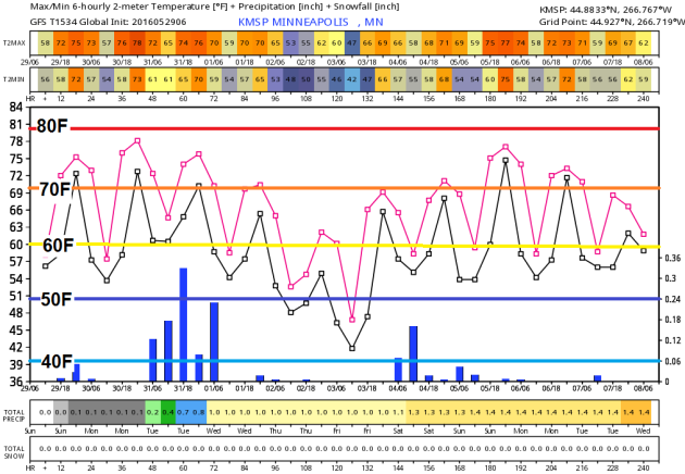
Extended Forecast
Take a look at the extended forecast below, which takes us into the first full week of June. Note that temperatures 'mild' through the early part of this week, but we begin to slip by the middle/end of the week with highs dipping into the 60s. Overnight lows will be a little more refreshing by the end of the week as we fall in the 40s; a few of the normal cool spots up north could even dip into the 30s. The good news is that I don't see any major frost of freeze concerns with this cool spat... Keep calm and garden on!
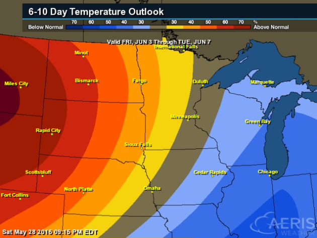
6 to 10 Day Temperature Outlook
According to NOAA's CPC, the 6 to 10 day temperature outlook suggests a return of warmer than average weather across the High Plains and parts of the Midwest from June 3rd to June 7th. So even after a little bit of a cool down mid/late week, we should be able to warm up again by next week!
Monday Weather Outlook
Monday WILL be the nicest day of the holiday weekend with bright sun and temperatures warming to near 10F above average across the state. The good news is that dewpoints will also be pretty comfortable in the 40s and low 50s, which by Minnesota standards isn't too shabby.
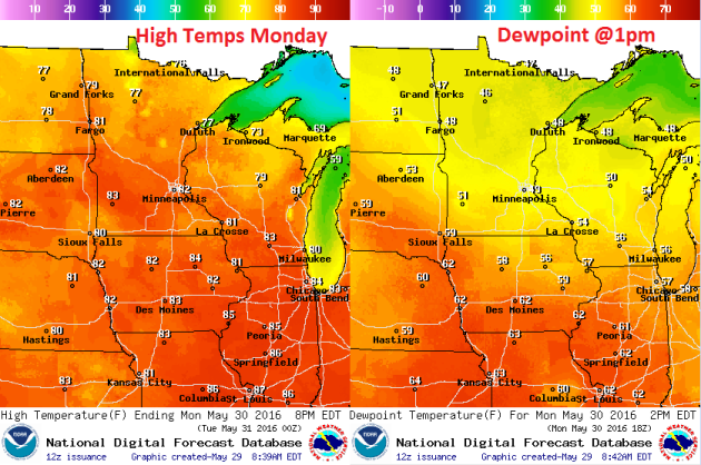
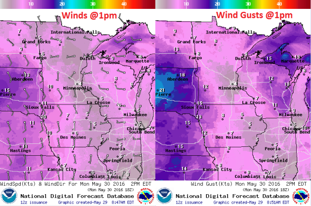
Winds on Monday will also be a non-factor for much of the day, however, note the increasing SE winds across South Dakota. This increase in wind speed is in advance of a storm system that will increase rain/thunder chances late PM Monday into Tuesday. Heavy rainfall and a few isolated strong storms can't be ruled out across parts of the Midwest from late PM Monday and again Tuesday.
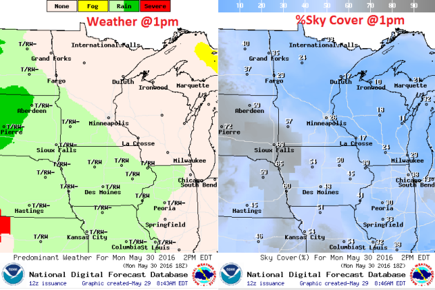
Again, Memorial Day Monday WILL be the nicest day of holiday weekend with plentiful sunshine across much of the state throughout much of the day. However, as we head into the second half of the day, high cirrus clouds look to move, which will make for filtered sunshine late across the Southwestern part of the state. Showers and storms will then move into MN & WI overnight Monday into Tuesday with heavy pockets of rain and isolated strong storm chances.
National Weather Outlook
The
national weather outlook through early next week shows slightly
improved weather conditions on Sunday across parts of the Central U.S.,
but another blob of heavier moisture looks to return to the Midwest as
Monday and Tuesday roll around. In fact, there is a chance of some
strong to severe storms along with heavier rainfall tallies.
Precipitation Outlook
According
to NOAA's HPC, the rainfall potential through the end of next week
suggests some of the heaviest rainfall across parts of the Central and
Southern Plains. Some 2" to 4"+ tallies can't be ruled out, especially
across parts of Oklahoma and Texas, where those amounts may be a little
more widespread. Also note the heavier band of rain along the East Coast
as our tropical system lifts NE along the coast there. Some spots in
the Mid-Atlantic region could see as much as 3" to 5"+ with the
potential of localized flooding.
US president Barack Obama, a friend to bees and other pollinating insects in peril, has unveiled his national strategy (pdf) to mitigate honey bee loss, increase the Monarch butterfly population, and restore the habitats of both insects, whose health is essential to our food supply. The program will depend heavily on federal agencies and will also involve Mexico and Canada, since bees and butterflies know nothing of state laws and don’t really care about borders. The strategic report includes a section on “expanding pollinator habitat on rights-of-way.” This doesn’t mean the feds will tell bees and butterflies who flies first, but rather that the US Department of Transportation and US Fish and Wildlife Service will help rehabilitate butterfly habitats alongside Interstate 35—a federal highway that extends from the Texas-Mexico border to Duluth, Minnesota.
See more from qz.com HERE:

Five Landmarks Threatened by Climate Change
Will a warming planet destroy humankinds' most precious cultural treasures?
Hunger, disease, dwindling natural resources—climate change promises to visit all of those misfortunes and more on humankind if it can’t be curbed. But there’s something else a changing climate can take away from humans, Fiona Harvey reports for The Guardian: their cultural heritage. A new UNESCO report suggests that some of the world’s most famous heritage sites could be destroyed by climate change. The report looks at the direct and indirect impacts of the changing climate on both UNESCO World Heritage sites and the tourism sector they support, calling it “one of the most significant risks” the sites face. Since cultural treasures are usually static and unable to move, says the report, they are inextricably tied to place—and as the landscapes that surround them change, they are uniquely vulnerable. From drought and rising seas to moles, here is a selection of landmarks facing climate change threats:
Read more from the SimthsoniaMag.com HERE:


No comments:
Post a Comment