75 F. average high on June 4.
75 F. high on June 4, 2015.
.06" rain fell yesterday at KMSP.
June 5, 1930: Heavy rain falls at Waseca. 4.3 inches of rain would fall over 24 hours.
June 5, 1915: This date marks the first of a long stretch of days of measurable rain at Winton near Ely. Measurable rain would fall on each day until 19th. The total amount of rain for the fifteen days was over six inches.
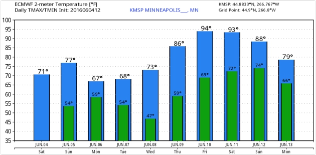
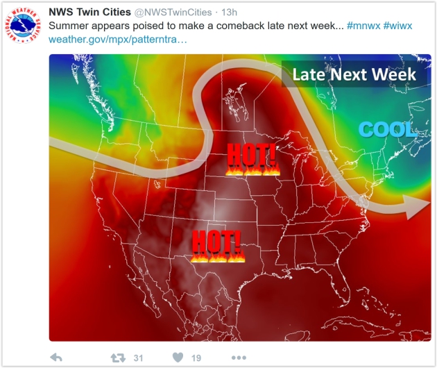
Hard To Believe: Late Week Hot Front Brewing
Minnesota will probably have weather-boasting-rights in perpetuity. On June 4, 1935 residents of Mizpah were buzzing about the 1.5 inches of snow that accumulated; the latest official measurable snowfall in Minnesota. Ouch.
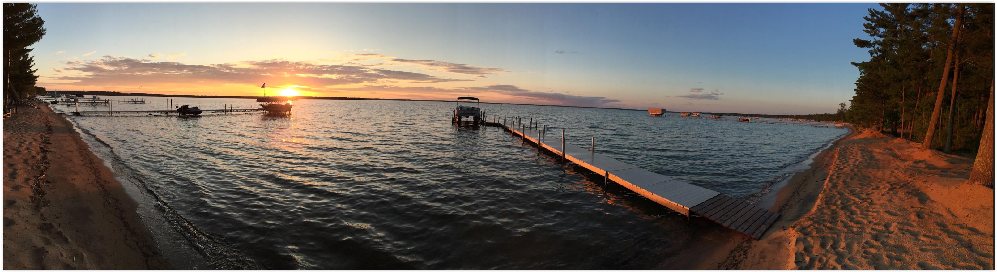
Yesterday was character-building with wind-whipped 50s and 60s, showers and wind chill. Instead of rocking the pontoon I spent the day cleaning the cabin. Great fun! But next weekend may feel 30-40 degrees warmer: 90s with a dew point near 70F that could make it feel like 100F in the shade by Saturday afternoon.
Just wear a sweatshirt over your swim suit and you'll be ready for anything.
Today is a baby-step in the right direction with enough sunshine for upper 70s. A few instability T-showers sprout over northern Minnesota & Wisconsin, but it won't be as foul as Saturday. A pinwheel of moisture pushes showers back into town Monday but skies clear Tuesday and Wednesday.
The same heat bubble cooking residents of Phoenix (highs near 115!) surges north late in the week: ECMWF guidance predicting 90s Friday and Saturday and a severe T-storm outbreak by Sunday.
* ECMWF forecast lows and highs for KMSP: WeatherBell.
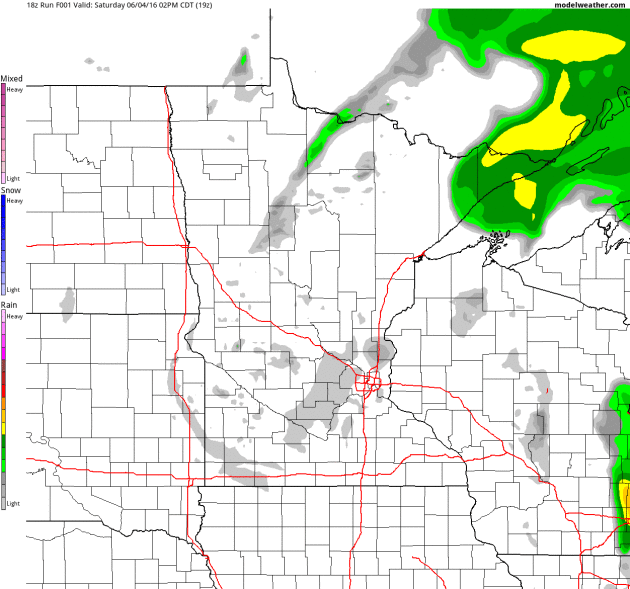
Drier Than Yesterday - Few PM Pop-Up Showers and T-showers.
Future Radar, courtesy of NOAA's 4 km NAM model hints at the best
chance of instability convection north and east of the Twin Cities
during the afternoon and evening hours. That said, today should be
sunnier, drier and warmer. Loop: AerisWeather.
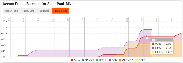
Shower Risk Returns Monday; Heavier Rains Early Next Week?
Models print out a little rain Monday, with dry weather the rule from
Tuesday into Saturday. ECMWF guidance is suggesting a few strong to
severe T-storms by Sunday; the pattern more favorable for significant
rain in 7-9 days. Source: Aeris Enterprise.
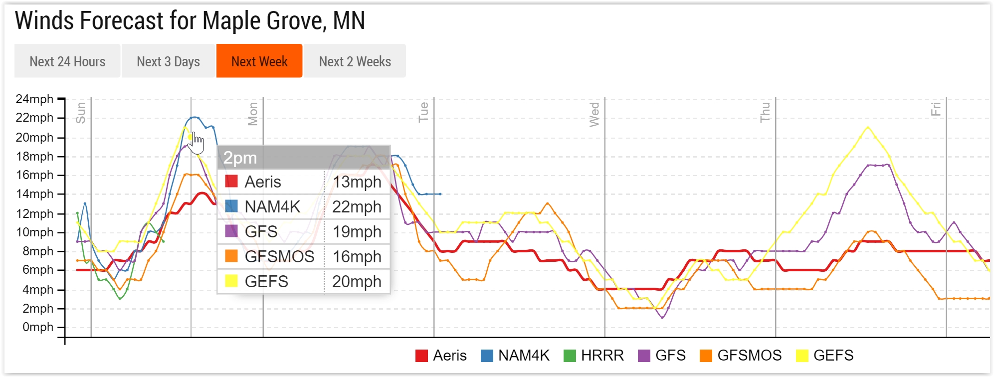
Gusty Winds Again Today.
Our internal model ensemble predicts sustained winds in the 16-22 mph
range by midday and afternoon with gusts as high as 25 mph. Winds ease
considerably by Tuesday and Wednesday.
GFS Tracking With ECMWF.
Although not as hot as the European model NOAA's GFS ensembles are
suggesting 90 degrees by Friday and Saturday as well. We'll go from
complaining about the "unusually cool weather" to griping about the heat
in the span of about 6 days.

* High confidence that a tropical storm (Colin) will form in the Gulf of Mexico by late Sunday, impacting Florida and Gulf Coast in a Monday-Tuesday time frame.
* Significant uncertainty remains about the track of this storm. Interests from New Orleans to Pensacola and Tampa should closely monitor this developing tropical cyclone.
* Enhanced risk of a significant severe thunderstorm outbreak Sunday for the Mid Atlantic region, including Philadelphia, Wilmington, Baltimore, Washington D.C., Richmond, Raleigh and Charlotte. Damaging hail and straight-line winds are expected by afternoon; I could see a few large, damaging tornadoes forming as well.

Developing Tropical Cyclone.
Although the smear of heavy showers and T-storms doesn't look
impressive (yet) conditions are ripe for strengthening over the next 48
hours with strong confidence Tropical Storm Colin will form within 48 hours. NOAA NHC says a 70% probability of tropical cyclone formation within 48 hours. Details:
A broad area of low pressure is located over the northwestern
Caribbean Sea, accompanied by a large area of showers and
thunderstorms.  Conditions appear to be favorable for some gradual
development of this low as it moves near the Yucatan Peninsula
and into the southern Gulf of Mexico on Sunday.  This system is
likely to become a tropical depression or a tropical storm by late
Sunday or on Monday as it moves northeastward toward the Florida
Peninsula.  Regardless of development, locally heavy rains
and flooding are possible over portions of the Yucatan Peninsula,
western Cuba, the Florida Keys, and the Florida Peninsula during the
next several days.  Interests in these areas should monitor the
progress of this system.  An Air Force Reserve Hurricane Hunter
aircraft is scheduled to investigate the system on Sunday.

* Formation chance through 48 hours...high...80 percent
* Formation chance through 5 days...high...80 percent

First Guess at Track.
There seems to be early model consensus on a track that would bring the
strongest winds, storm surge and rainfall amounts over Florida by Monday and Monday
night, but it's early in the process, and a more westward track (closer
to Pensacola, even New Orleans) cannot be entirely ruled out.
Track graphic: Tropical Tidbits.

Tropical Storm Strength Likely.
Nearly all models bring sustained winds for "Colin" up to tropical
storm intensity (greater than 39 mph). Although hurricane strength is
unlikely, we may be looking at a moderate to strong tropical storm
impacting Florida and the Gulf Coast early next week.

European Solution.
The ECMWF model (which we tend to favor for tropical systems) brings a
weak to moderate tropical storm into the eastern Gulf of Mexico by Monday
evening, with heaviest rains projected for northern Florida and the
Panhandle. This solution suggests more torrential rains for the coastal
Carolinas, which may result in additional flash flooding for counties
impacted by Bonnie earlier in the week.
Map credit above: WSI.

12 KM NAM Solution.
By late afternoon Monday the center of (Tropical Storm Colin) is
forecast to be due south of Biloxi, with greatest storm impacts north
and east of the storm center. (Map: WeatherBell).

4 KM NAM Solution. High-resolution NAM guidance shows a similar solution, the forecast map above valid Monday
evening, showing the most intense rain bands impacting the Gulf Coast
of Florida. High surf and heavy rain is expected from the Florida Keys
and Naples to Tampa and the Panhandle.

Rainfall Potential.
Models are printinig out some 4-8" rainfall amounts from near Tampa and
Orlando into the Florida Panhandle and southern Georgia. I expect
considerable inland flash flooding from this system from late Sunday into Tuesday. Facilities that often flood may experience problems as rain bands from Colin push ashore. (Graphic credit: WeatherBell).

The Other Big Weather Risk Story: Damaging Sunday Winds Mid Atlantic Region. Here is the NOAA SPC forecast for severe thunderstorm damage risk on Sunday,
showing an "enhanced" probability of large hail, damaging straight-line
winds, even a few large and damaging tornadoes, most likely by late
afternoon and evening. Major metropolitan areas are in the bulls-eye,
including Philadelphia, Harrisburg, Baltimore, Washington D.C., Norfolk
and Raleigh. The greatest risk is hail and straight-line winds, but
conditions may be ripe for a few large, damaging tornadoes tomorrow. (Map credit: NOAA SPC).
Summary:
we are closely monitoring 2 main threats: the birth of Tropical Storm
Colin in the Gulf of Mexico, likely to impact Florida and the (eastern)
Gulf Coast by Monday,
and a potentially major severe thunderstorm outbreak Sunday afternoon
and evening impacting the Mid Atlantic states. We'll have an update on
both threats tomorrow morning.
Paul Douglas, Senior Meteorologist, AerisWeather

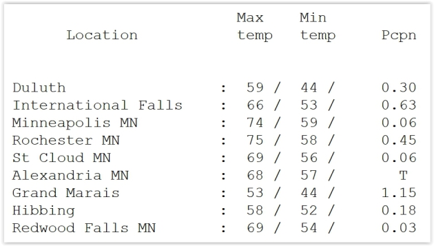
May Closes Wet For Some. Dr. Mark Seeley has a good recap of May and an assortment of other timely, interesting weather nuggets in this week's edition of Minnesota WeatherTalk; here's the intro: "The last week of May brought frequent, and sometimes heavy rains to many parts of the state. for some northern Minnesota climate stations it rained each day over the last week of the month. Sotty thunderstorms brought some new record daily rainfall amounts over the last day of May, including 0.99 inces at Lakefield; 1.67 inches at Hokah; 1.29 inches at La Crescent; 1.27 inches at Austin; 1.19 inches at Hallock; and an incredible 4.45 inches at Crookston. That amount at Crookston ranked as the 4th highest daily rainfall in history there...."

Photo credit: "Mike Akulow, who retired in 2005 after more than 30 years with the National Weather Service in Topeka, says technology used at the time of the June 8, 1966, tornado was "very crude." Today, GPS technology, radar upgrades and an Internet-based chat system has improved the quality and quantity of weather information available."

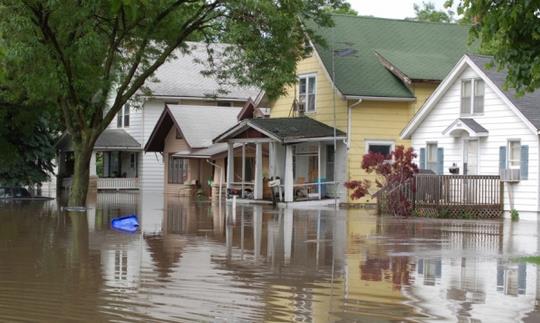
Tough Guy Tries To Drive Across Flood, Fails Miserably. Geekologie reminds all of us what not to do when encountering a flooded highway: "This is a video of a man in Texas who really believes his Chevy Avalanche can get him across a heavily flooded road. So, at least in his mind, Avalanches > Floods. Unfortunately for his pride and dry underwear, he is wrong and has to jump out and swim to safety. This is dangerous and you shouldn't do it, I don't care how big you think your Truck Nuts are..."
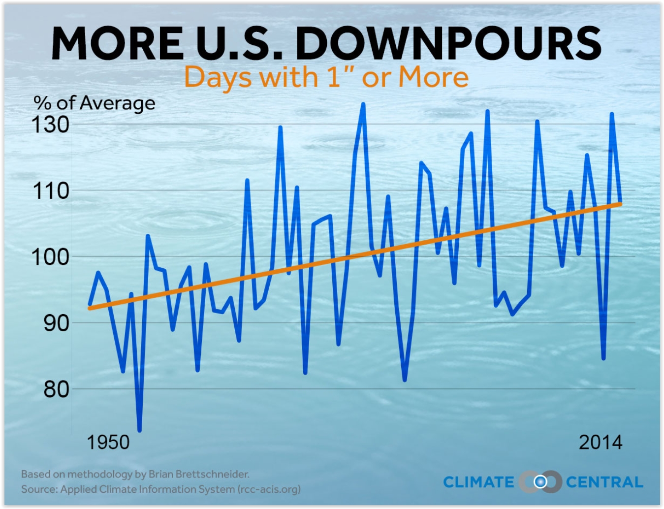
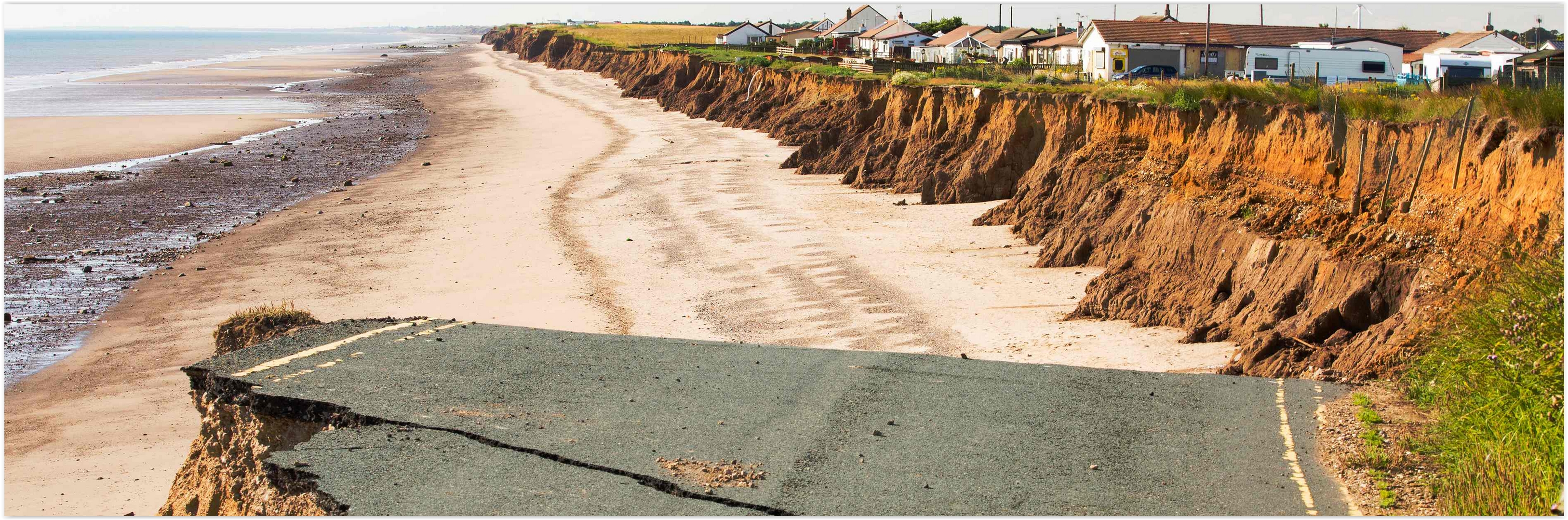
Across U.S., Heaviest Downpours On The Rise. Here's an excerpt of an analysis at Climate Central: "...Across most of the country, the heaviest downpours are happening more frequently, delivering a deluge in place of what would have been routine heavy rain. Climate Central’s new analysis of 65 years of rainfall records at thousands of stations nationwide found that 40 of the lower 48 states have seen an overall increase in heavy downpours since 1950. The biggest increases are in the Northeast and Midwest, which in the past decade, have seen 31 and 16 percent more heavy downpours compared to the 1950s..."
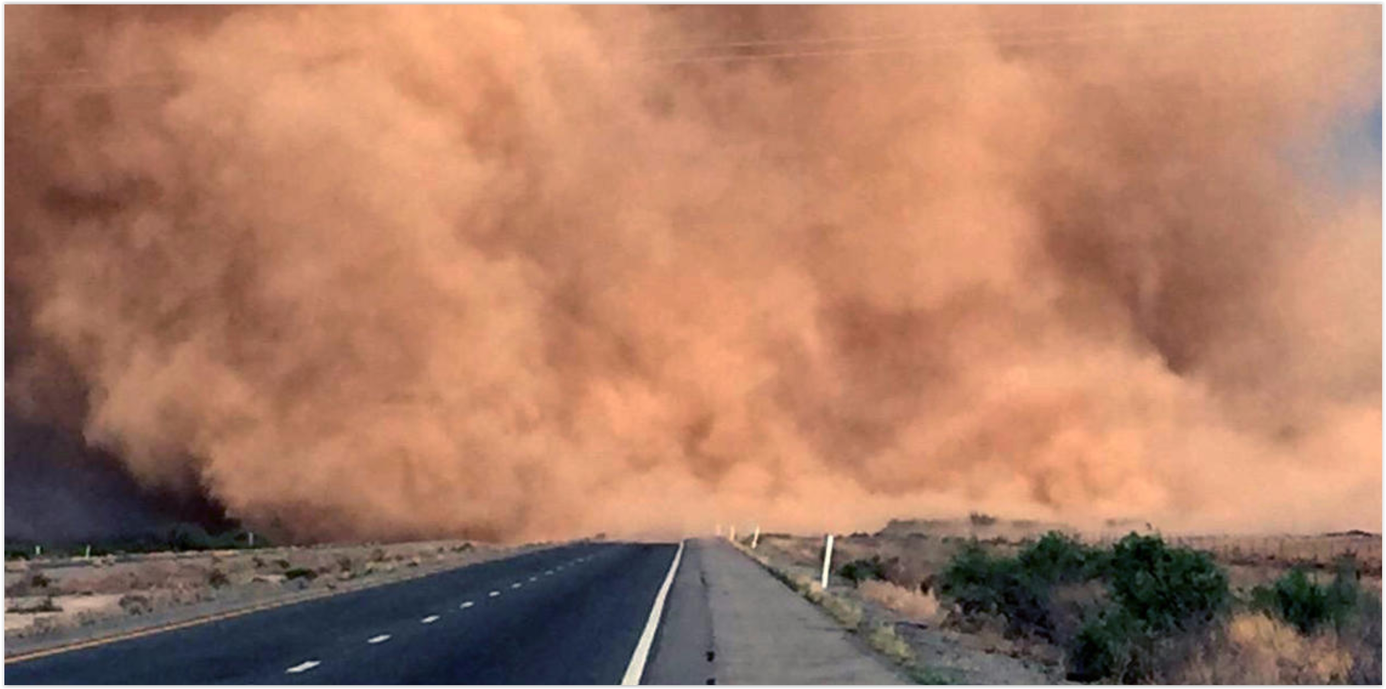
It's Summer in Arizona. Time To Come Inside. The L.A. Times summarizes the challenges of summer-living in Arizona; here's the intro: "In northern climes, dead leaves, gardeners bringing their plants inside and children praying for school closures all signal one thing: Winter is blowing in hard and mean. Here in Arizona, they mark something else. It’s not winter. It’s summer. The leaves are curling up and dying of heat. Gardeners bring in their plants, fearing not frost but the first truly hot day. And when children supplicate a higher power for bad weather, they're praying for school-shuttering monsoons..."
Photo credit: "A desert dust storm known as a haboob engulfs Interstate 10 near San Simon, Ariz., in May." (Arizona Department of Public Safety / Associated Press).


A Suburban Experiment Aims for Free Energy. Yes, free has a nice ring. Here's the intro to a New York Times story: "At
first glance, Anthony and Vanessa Genau’s home in a subdivision beneath
the San Gabriel Mountains here is like any other gracious new suburban
dwelling, with an open-plan living space, granite countertops and
stainless steel appliances. But, along with 19 other cream, taupe and
rust stucco houses that cradle the landscaped playgrounds here, it is
actually something else: a large-scale testing ground for an energy
system of the very near future. With a combination of rooftop solar
panels, smart thermostats, advanced water heaters and other
high-efficiency features, the homes are all built with a similar goal:
to make at least as much energy as they use over a year..."

10 Household Expenses You Can Eliminate Right Now. If not eliminate, maybe trim? Here's an excerpt of a helpful post at Trulia: "Paying
bills is never fun, but it’s even less exciting when those monthly
expenses: a) keep you from enjoying the cultural events and great
restaurants your city has to offer; or b) leave you eating noodles for
the last few days before every payday. But you don’t necessarily have to
sacrifice the lifestyle you want to live in an apartment or home you
love. In fact, it’s probably easier than you think to eliminate some of
those unnecessary household expenses..."
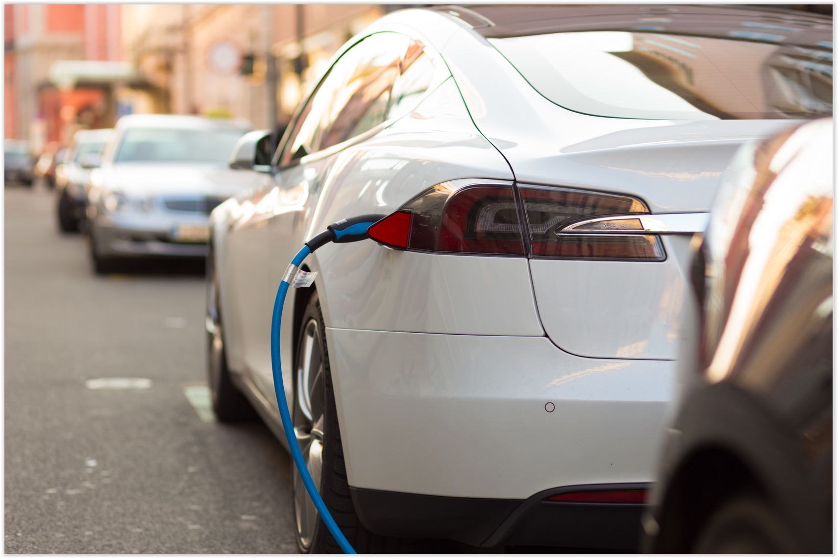
The Trends Driving Electric Vehicle Development. It's a convergence of factors, according to TechCrunch: "...Three
technology trends are converging in automobile transportation — and not
a minute too soon, given the giant emissions and human carnage wrought
by conventional vehicles:
- In my view, Tesla has demonstrated that electric vehicles can result in a superior automotive product in terms of driving performance, safety, comfort and even convenience.
- On-demand and ridesharing services shifted billions of car miles (including more than 1.5 billion miles on Uber alone) to their offering and made the case that ownership is an unnecessary and perhaps even negative part of the car experience..."
That
could be bad news for SolarCity and Sunrun, two big solar providers
that currently dominate the U.S. residential solar market. Both
companies have built their businesses around long-term leases, and
third-party ownership of rooftop solar stood at 72 percent in 2014.

A Worldwide Health Check Up. The new Vital Signs series at How We Get To Next is worth your time; here's an excerpt: "Active
energy. Basal body temperature. Blood glucose. Body mass index.
Caffeine intake. Calories ingested. Electrodermal activity. Forced vital
capacity. Heart rate. Hydration level. Oxygen saturation. REM cycles.
Respiratory rate. UV index. These days, we can track just about every
vital sign and body movement we make — and mostly with free apps on our
smartphones. Monitoring and understanding our health is, quite
literally, at our fingertips. And
yet, more Americans are dying. Or at least, given an adult mortality
rate that’s been steadily decreasing over the past half century in the
United States and globally, they did last year..."

Image credit: "The classic purveyors of Canadian accents in the U.S.—from sketch comedy troupe SCTV." (Photo: YouTube).

TODAY: Lukewarm sun returns; PM shower north/east of MSP. Winds: NW 10-20. High: 79
SUNDAY NIGHT: Partly cloudy. Low: 57
MONDAY: More clouds, a few showers likely. Winds: NW 15-25. High: 67
TUESDAY: Skies clear, moods improve. Winds: NW 10-15. Wake-up: 52. High: 71
WEDNESDAY: Plenty of sun, warming up. Winds: SE 7-12. Wake-up: 54. High: 78
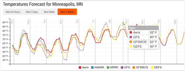
THURSDAY: Early thunder possible, then sticky sun. Winds: SE 10-15. Wake-up: 60. High: 85
FRIDAY: Hazy sun, plenty hot. Winds: S 10-15. Wake-up: 68. High: 92
SATURDAY: Steamy sun, escape to the lake. Dew point: 70. Winds: S 10-20. Wake-up: 71. High: 93
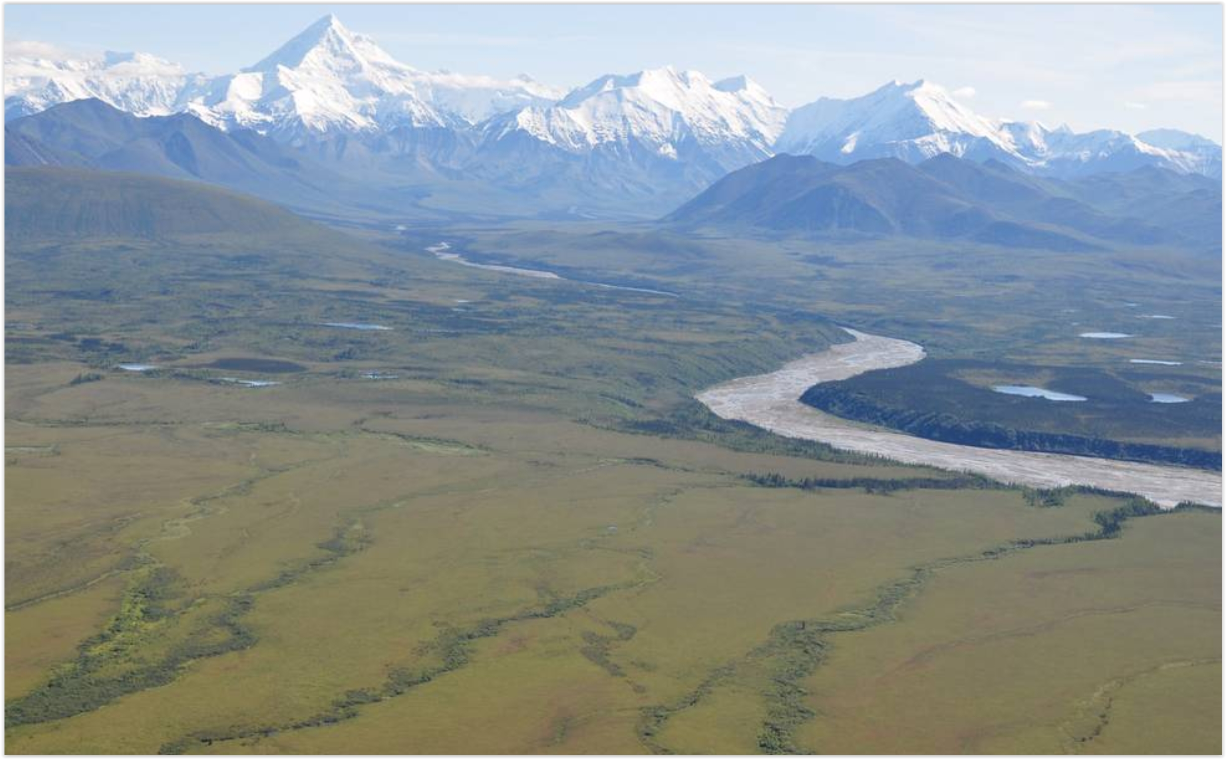
Global Warming is Greening Up The Far North. More tangible evidence of the changes underway, reported at Summit County Citizens Voice; here's an excerpt: "After taking a close look at 87,000 satellite images, NASA scientists say the northern parts of Canada and Alaska are getting greener. Shrubs are sprouting in grassy tundra zones and shrubs are growing bigger and denser — changes that could have impacts on regional water, energy and carbon cycles. The new NASA study adds more detail to previous research that reached similar conclusions and could help inform climate scientists about how the changes will affect global temperatures. The study covered the timespan between 1984 and 2012. The images came from the joint NASA/U.S. Geological Survey Landsat program, which provides the longest continuous space-based record of Earth’s land vegetation in existence..."
Photo credit: "NASA scientists have detailed a widespread greening trend across Alaska and northern Canada in a new study." Photo courtesy NASA/Ross Nelson.
From Floods to Forest Fires: A Warming Planet - In Pictures. The Guardian has the photo essay; here's a link and story excerpt: "Droughts, floods, forest fires and melting poles – climate change is impacting Earth like never before. From the Australia to Greenland, Ashley Cooper’s work spans 13 years and over 30 countries. This selection, taken from his new book, shows a changing landscape, scarred by pollution and natural disasters – but there is hope too, with the steady rise of renewable energy..."


Photo credit: Rex.
No comments:
Post a Comment