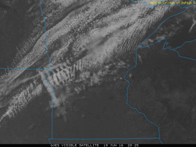
Recap: Stormy Sunday Night
Take a look at the storms that exploded PM Sunday across central and northeast MN. These storms were responsible for extremely large hail and even tornadoes.
Take a look at the storms that exploded PM Sunday across central and northeast MN. These storms were responsible for extremely large hail and even tornadoes.
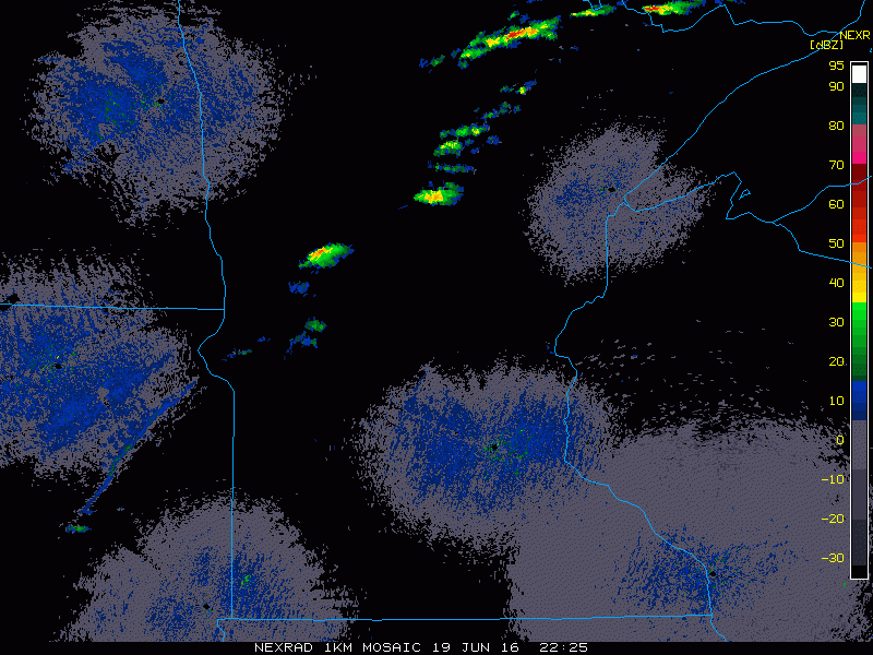
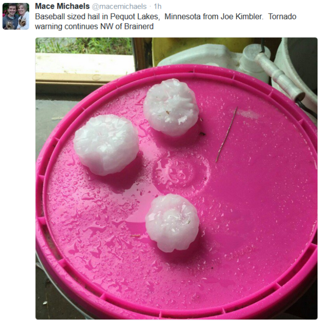
Several Storm Reports Sunday
There
were a number of large hail reports (up to grapefruit size (4") near
Nisswa) and even tornado reports. The National Weather Service out of
Duluth conducted storm surveys on Monday and this is what they found:
Public Information Statement
National Weather Service Duluth MN
503 PM CDT MON JUN 20 2016

...NWS DAMAGE SURVEY FOR JUNE 19TH 2016 EVENT...

.TORNADO NEAR JACOBSON, MN

Rating:                 EF-1  - Preliminary
Path length /Statute/:  8 miles
Path width /Maximum/:   A quarter mile
Fatalities:             0
Injuries:               0

Start date:             June 19, 2016
Start time:             6:49 PM CDT
Start location:         2 miles northeast Jacobson

End date:               June 19, 2016
End time:               6:59 PM CDT
End location:           2 miles east southeast of Wawina

.WIND DAMAGE CROW WING COUNTY...POSSIBLE TORNADO.

An NWS Storm Survey is still ongoing.  Damage is widespread and varied in nature
across southern Cass, Crow Wing, and southern Aitkin county. Information will be
updated as it becomes available.

EF Rating table

EF0...Weak......65 to 85 mph
EF1...Weak......86 to 110 mph
EF2...Strong....111 to 135 mph
EF3...Strong....136 to 165 mph
EF4...Violent...166 To 200 mph
EF5...Violent...>200 mph

NOTE:
The information in this statement is PRELIMINARY and subject to
change pending final review of the events and publication in
NWS Storm Data.

$$

NWS DLH
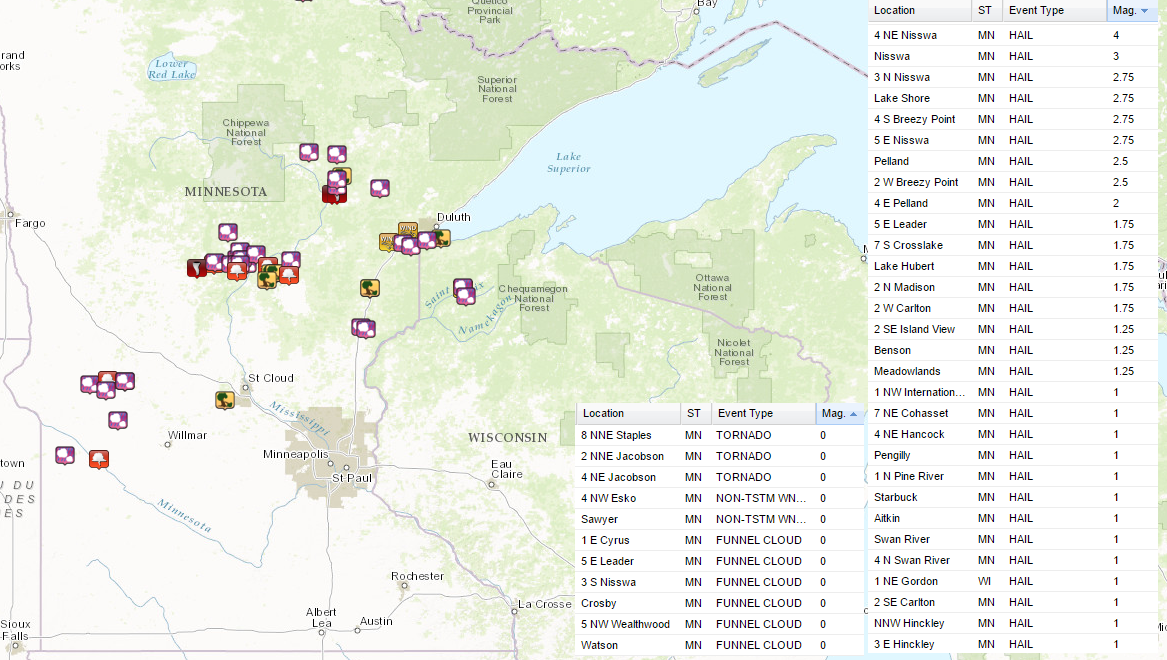
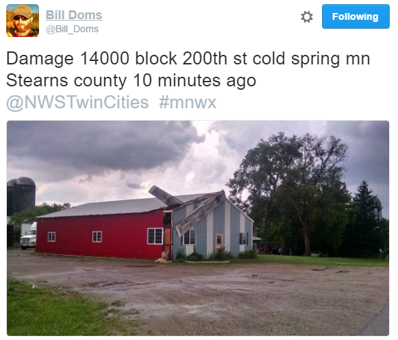
Severe Storms Sunday
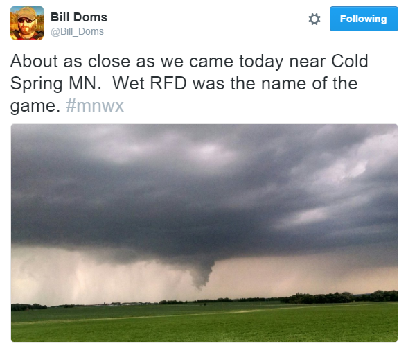
Thanks to @Bil_Doms for this picture from near Cold Spring in Stearns county from PM Sunday.
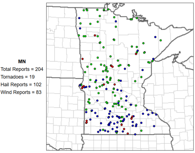
Large Hail Reports

____________________________________________
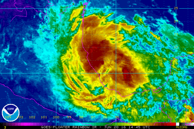
Tropical Storm DANIELLE
The
National Hurricane Center started issuing statements on Tropical
Depression FOUR in the Bay of Campeche Sunday afternoon and by AM
Monday, it was upgraded to a tropical storm. DANIELLE is expected to
continue pushing west into mainland Mexico before diminishing rather
rapidly over land on Tuesday.
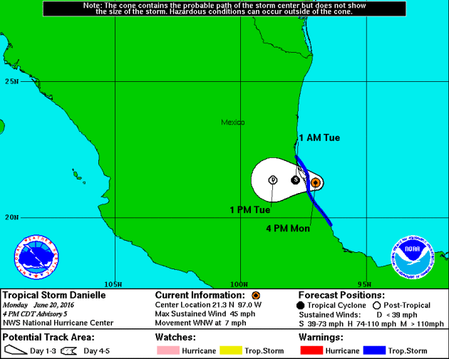
Tracking DANIELLE
Here's
the official forecast track for DANIELLE, which shows the system making
landfall in central Mexico around midday Monday and then falling to
tropical depression status by early Tuesday morning.
____________________________________
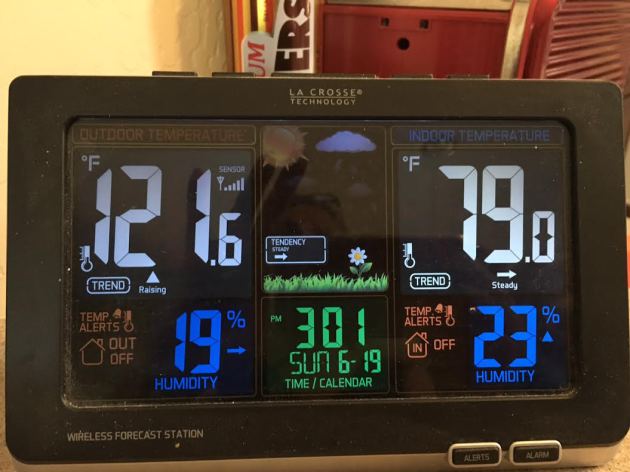
HOT HOT HOT!
Thanks
to my mom for sending me this picture from Phoenix, AZ, where their
outdoor thermometer on Sunday was already reading 121F by midday! Good
grief! Sunday was expected to be the hottest day of the heat wave
topping out near 120F with a slight cool down on Monday to 115F - that
heat is no joke!
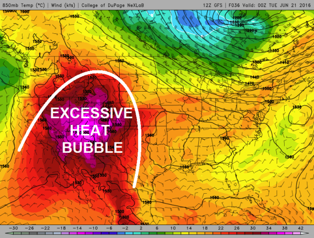
Excessive Heat Continues in the Southwest
This
impressive dome of hot weather will continue into early this week with
high temperatures in many locations will warm into the triple digits!
Some may even be in record territory through the early week time frame.
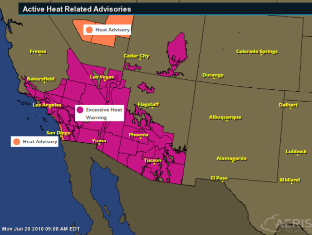
Excessive Heat Watches and Warnings
The
National Weather Service has issued a number of excessive heat
headlines across the Southwest, which includes major cities like San
Diego, Los Angeles, Las Vegas, Phoenix, Tucson and Yuma.
...EXCESSIVE HEAT WARNING REMAINS IN EFFECT UNTIL 9 PM MST /9 PM PDT/ WEDNESDAY...
*
AFFECTED AREA...THE SOUTHEAST CALIFORNIA...SOUTHWEST AND SOUTH CENTRAL
ARIZONA DESERTS AND MOUNTAIN VALLEYS INCLUDING THE GREATER PHOENIX
AREA...THE IMPERIAL VALLEY OF CALIFORNIA...THE COLORADO RIVER...GLOBE
MIAMI...THE SALT RIVER RECREATIONAL LAKES...AND ROOSEVELT LAKE.
*
TEMPERATURE...HIGHS MONDAY IN THE LOWER DESERTS FROM 115 TO 120
DEGREES. HIGHS TUESDAY AND WEDNESDAY FROM 110 TO 115. IN THE HIGHER
TERRAIN OF SOUTHERN GILA COUNTY...HIGH TEMPERATURES WILL TOP OUT FROM
105-110 DEGREES MONDAY AND TUESDAY.
*
IMPACTS...HEAT RELATED ILLNESS WILL BE LIKELY FOR THOSE DOING STRENUOUS
ACTIVITY OUTDOORS...OR THOSE WITH HEALTH CONDITIONS THAT DO NOT HAVE
ADEQUATE ACCESS TO AIR CONDITIONING. IF UNTREATED...SOME ILLNESS EVENTS
COULD BE FATAL.
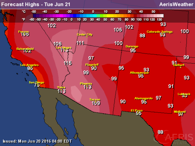
Potential High Temperatures & Stats
Phoenix, AZ
- Phoenix has only had a high of 120 or higher three times in their recorded history (since 1895).
- The last time Phoenix hit 120 or higher was back on July 28, 1995 when the thermometer hit 121.
- Whether the temperature touches 120 or not, record highs are likely. The current record high each day between Saturday and Tuesday is 115.
- The last time Phoenix hit 120 or higher was back on July 28, 1995 when the thermometer hit 121.
- Whether the temperature touches 120 or not, record highs are likely. The current record high each day between Saturday and Tuesday is 115.
Tucson, AZ
-
Only seven times in Tucson recorded history (since 1894) has the city
seen a high of 114 or higher – the last time occurring on July 28, 1995
when it also reached 114.
- The all-time record in Tucson history is 117 set back on June 26, 1990.
- Record highs: 112 Tuesday.
- The all-time record in Tucson history is 117 set back on June 26, 1990.
- Record highs: 112 Tuesday.
Las Vegas, NV
-
Las Vegas is no stranger this type of higher heat in the forecast,
reaching a temperature of 115 or higher 55 times since 1937. The last
time Las Vegas saw a high of 115 or higher was back on July 2, 2013.
- The warmest high ever in Las Vegas history is 117 reached three times in their history. The most recent occurrence was back on June 30, 2013.
- Our forecast has Las Vegas reaching 114 on Tuesday.
- Record high: 111 Tuesday.
- The warmest high ever in Las Vegas history is 117 reached three times in their history. The most recent occurrence was back on June 30, 2013.
- Our forecast has Las Vegas reaching 114 on Tuesday.
- Record high: 111 Tuesday.
Los Angeles, CA
- Even Los Angeles will get in on the heat this week into early next week, reaching at least the mid 90s through Tuesday.
(Stats courtesy: DJ Kayser @DKayserWX)
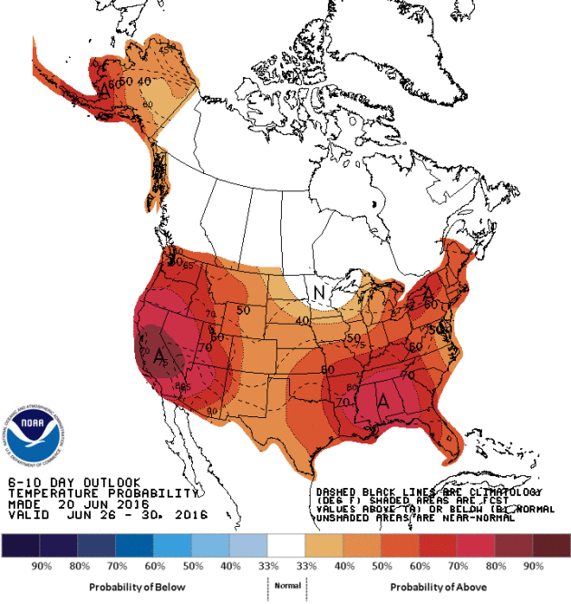
When will the heat end?
According
to NOAA's CPC, the 6 to 10 day temperature outlook still suggest warmer
than average weather continuing into next week with some of the heat
spilling back out into the Plains. It appears that the 2nd half of June
will remain VERY summer-like for many locations in the western half of
the country.
Heavy Rainfall Last Week
Here's
a look at rainfall from AM June 13th to AM June 18th. Note that there
were several locations that saw 1" to 2"+ amounts with some spots even
seeing 3" to 4"+. Here's an excerpt from Mark Seeley's Weather Talk on
the heavy rains last week.
The
warm and humid conditions of last weekend help set the stage for
numerous thunderstorms this week across much of the state. Recall that
the weather of last weekend produced widespread readings in the 90s F
around the state, including a record high of 98°F at Winnebago on the
11th, and a record high of 96°F at Lake Wilson on the same date. Many
observers also reported near record dew points in the 70s F, leading to
Heat Index readings over 100°F in many places. This represents a large
quantity of water vapor which does not allow the air to cool off much at
night. As a result, Tracy set a new record warm minimum temperature on
the 10th, with a reading of 73°F.
All of the water vapor in the atmosphere served as fuel for thunderstorms, which became widespread across the state over June 11-14. Over those 4 days many areas received from 2-4 inches of rain. A few highly localized amounts were even greater causing some short-lived flooding concerns. You can read more about the distribution of these storms at the Minnesota StateClimatology Office web site.
All of the water vapor in the atmosphere served as fuel for thunderstorms, which became widespread across the state over June 11-14. Over those 4 days many areas received from 2-4 inches of rain. A few highly localized amounts were even greater causing some short-lived flooding concerns. You can read more about the distribution of these storms at the Minnesota StateClimatology Office web site.
Some
climate stations reported new daily rainfall records as a result of
these thunderstorms. These included: on the 11th Lake City 2.03 inches;
on the 12th Thorhult 1.70 inches; on the 13th Eveleth 2.51", Dassel
3.19", Embarrass 1.96", and Stillwater 1.54"; on the 14th Amboy 2.00";
and on June 15th record values were reported for La Crescent 1.78",
Melrose 1.80", Caledonia 1.51", Harmony 2.07", Houston 2.83", Waseca
3.19", and Forest Lake 2.00".
The
strong thunderstorms on June 14th produced tornadoes in Pipestone,
Traverse, Big Stone, Le Sueur, and Blue Earth Counties. All were
relatively short-lived and produced relatively little damage. Very
strong winds up to 60mph were also reported from portions of Nobles,
Jackson, Cottonwood, Brown, and Watonwan Counties.
As a result of the rainy week, many climate stations are already reporting total monthly rainfall that exceeds the June normal. This continues a recent climate trend for June, as 15 of the most recent Junes have been normal or wetter than normal on a statewide basis.
As a result of the rainy week, many climate stations are already reporting total monthly rainfall that exceeds the June normal. This continues a recent climate trend for June, as 15 of the most recent Junes have been normal or wetter than normal on a statewide basis.

Sunny Tuesday gives way to a stormy Wednesday
By Todd Nelson, filling in for Douglas.
Whether
you like it or not, daylight hours will begin dwindling today. We are
post summer solstice, so it'll be a steady decline in the daylight
category over the next 6 months. However, our average high and low
temperature will continue to warm over the next 4 weeks due to a process
known as "Seasonal Lag".By Todd Nelson, filling in for Douglas.
It is similar to the daily occurrence when daytime highs typically occur after peak solar radiation (midday) and overnight lows typically occur just after sunrise. Because our atmosphere is a fluid, it takes a little longer to warm and cool, so these "lags" not only happen on a daily basis, but also on a seasonal basis.
Temperatures over the next few days will hover around average with spotty shower and thunderstorm chances returning late tonight into Wednesday. The extended forecast suggests another bubble of heat arriving this weekend with some spots nearing 90 degrees.
By the way, Sunday's high of 93 degrees tied the warmest high this year! It was the 4th 90+ of the year and was also the 6th tornado day of 2016.
___________________________
Extended Forecast
MONDAY NIGHT: Mostly clear and a little breeze. Winds: WNW 5-10. Low: 60.
TUESDAY: Beautiful! Low humidity and bright sun. Spotty thunder chance develops overnight. Winds: WNW 5-10. High: 82
TUESDAY NIGHT: Increasing clouds. Slight chance of a shower or storm late. Winds: WNW 5. Low: 62.
WEDNESDAY: More clouds, lingering t-storm risk. Winds: NE 5-15. High: 80
THURSDAY: Lingering AM shower, sunnier by PM. Fresh breeze. Winds: N 5-10. Wake-up: 62. High: 78.
FRIDAY:Breezy and warmer. Stray PM rumble. Winds: SSE 10-15. Wake-up: 63. High: 82
SATURDAY: Sticky with scattered storms possible. Winds:WSW 10-20. Wake-up: 69. High: 86.
SUNDAY: Unsettled. Late day T-showers. Winds: SW 10-15. Wake-up: 69. High: 86.
MONDAY: Cooler breeze. Cloudy. Spotty T-showers. Winds: NNW 10-15. Wake-up: 58. High: 79.
______________________________
______________________________
This Day in Weather History
June 21st
June 21st
1989: Fairmont has a wind gust of 76 mph during a severe thunderstorm.
_______________________________
_______________________________
Average High/Low for Minneapolis
June 21st
June 21st
Average High: 81F (Record: 95F set in 1910)
Average Low: 61F (Record: 39F set in 1992)
________________________________
Average Low: 61F (Record: 39F set in 1992)
________________________________
Sunrise/Sunset Times for Minneapolis
June 21st
June 21st
Sunrise: 5:27am
Sunset: 9:03pm
Sunset: 9:03pm
*Daylight LOST since yesterday: ~1second
*Daylight LOST since Summer Solstice (June 20th): ~1second
__________________________________
*Daylight LOST since Summer Solstice (June 20th): ~1second
__________________________________
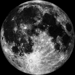
Moon Phase for June 21st at Midnight
1.8 Days After Full (Strawberry) Moon
1.8 Days After Full (Strawberry) Moon
June 20, 6:03 a.m. CDT — The Full Strawberry Moon. Known to every Algonquin tribe by that name. Europeans called it the Rose Moon. - Courtesy Space.com HERE:
____________________________________
Extended Outlook
Temperatures
look to remain near average over the next several days, but the
forecast into the weekend suggests another warm bubble arriving with a
brief stint of higher humidity values.
______________________________
Tuesday Weather Outlook
High
temperatures on Tuesday will be a little warmer than what we saw on
Monday with highs in the lower 80s in southern MN. Although it'll be a
littel warmer, dewpoints won't be too bad, so it'll be another
comfortable day with more sunshine.
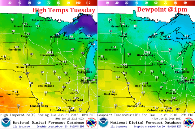
Tuesday Weather Outlook
Winds
will continue out of the west on Tuesday and still be a bit on the
breezy side across parts of northeastern MN and into Wisconsin.
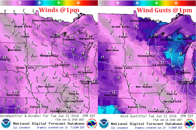
Tuesday Weather Outlook
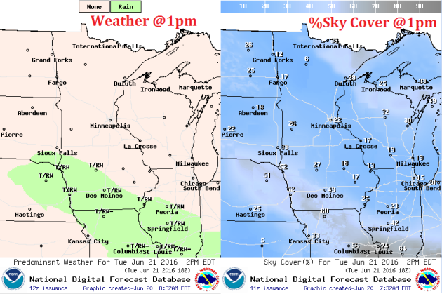
No
worries on Tuesday. Weather conditions look mostly dry with plenty of
sunshine across the region. There is a chance of spotty showers and
storms arriving late Tuesday night across parts of southern MN.
Simulated Radar
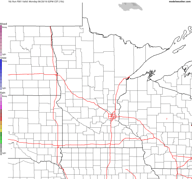
Here's
the simulated radar through Wednesday night, which shows much quieter
conditions through most of Tuesday.However, unsettled weather looks to
return as we head into the late PM Tuesday to Wednesday time frame.
Rainfall Potential
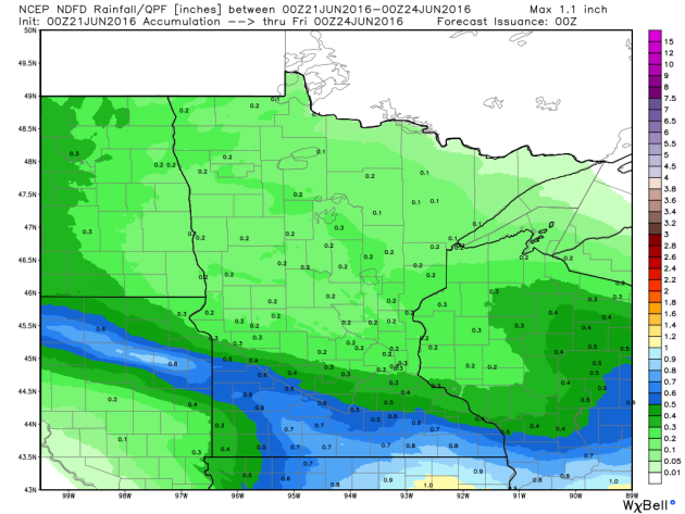
Here's
the rainfall potential through 7pm Thursday, which shows spotty heavy
rainfall potential across far southern MN as showers and storms push
back into the region late Tuesday into Wednesday.
___________________________________
National Weather Outlook
A
cold front that swept through the Ohio Valley on Monday will stall out
in that area on Tuesday keeping the shower and thunderstorm threat in
those areas during the day. A developing storm system will ignite more
storms in the region again on Wednesday with chances of severe storms.
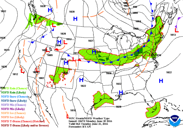
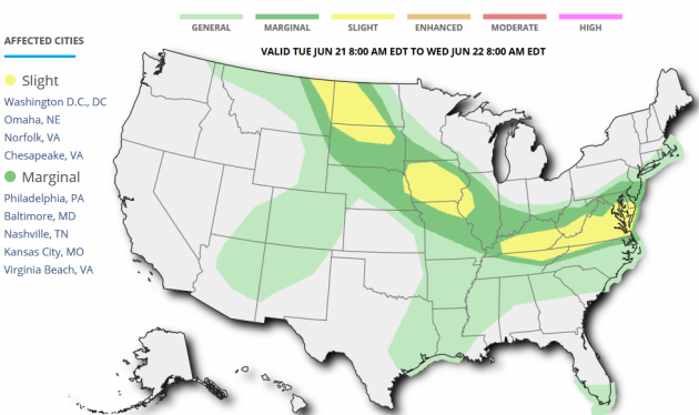
...SUMMARY...
   SCATTERED STRONG TO SEVERE STORMS ARE POSSIBLE FROM THE TENNESSEE
   VALLEY AREA EASTWARD TO THE DELMARVA ON TUESDAY.  STRONG TO SEVERE
   STORMS ARE ALSO FORECAST ACROSS PARTS OF NORTHEAST MONTANA AND INTO
   PORTIONS OF THE DAKOTAS.  FINALLY...ISOLATED SEVERE STORMS MAY
   DEVELOP TUESDAY AFTERNOON AND EVENING FROM FAR EASTERN NEBRASKA INTO
   NORTHWESTERN ILLINOIS.  WIND AND HAIL WILL BE THE PRIMARY THREATS IN
   ALL AREAS.

   ...SYNOPSIS...
   A BROAD/W-E UPPER RIDGE ACROSS THE CENTRAL AND SRN U.S. WILL LIKELY
   BE SUPPRESSED SWD THIS PERIOD...AS TWO TROUGHS IN THE FASTER/MORE
   ACTIVE WLYS ADVANCE EWD.  THE FIRST -- A COMPACT SHORT-WAVE FEATURE
   -- IS FORECAST TO MOVE EWD ACROSS MT AND ADJACENT SRN
   CANADA...REACHING THE NRN PLAINS LATE.  THE SECOND TROUGH -- A MUCH
   LARGER SYSTEM CENTERED OVER ONTARIO AND QUEBEC -- IS PROGGED TO
   EXPAND GRADUALLY SWD ACROSS THE NERN U.S. WITH TIME...WITH CYCLONIC
   FLOW SURROUNDING THE TROUGH FORECAST TO ENCOMPASS MUCH OF THE U.S. E
   OF THE MS VALLEY.

   AT THE SURFACE...A COLD FRONT IS FORECAST TO SHIFT EWD ACROSS NEW
   ENGLAND AND EVENTUALLY MOVE OFF THE COAST OVERNIGHT.
   MEANWHILE...THE BOUNDARY IS FORECAST TO SAG MORE SLOWLY SWD ACROSS
   SRN PA INTO THE MID-ATLANTIC STATES INTO EARLY EVENING.  TRAILING
   PORTIONS OF THIS FRONT...EXTENDING WWD ACROSS THE LOWER OH AND MID
   MS VALLEYS AND THEN NWWD ACROSS THE PLAINS INTO ERN MT...IS FORECAST
   TO BEGIN SHIFTING NEWD ACROSS THE MO VALLEY REGION AS A WARM FRONT
   THROUGH THE AFTERNOON AND INTO THE OVERNIGHT HOURS.  THIS ARC-SHAPED
   FRONT WILL FOCUS THE MAIN BAND OF CONVECTIVE/SEVERE RISK ACROSS THE
   CENTRAL AND ERN U.S. THIS PERIOD.
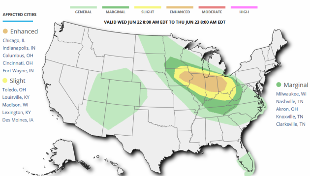
Severe Threat Wednesday
...SUMMARY...
   SEVERE STORMS CAPABLE OF WIDESPREAD DAMAGING WIND...A FEW TORNADOES
   AND LARGE HAIL ARE POSSIBLE ACROSS A LARGE AREA FROM THE UPPER
   MISSISSIPPI VALLEY SOUTHEASTWARD INTO THE OHIO VALLEY DURING THE DAY
   AND OVERNIGHT ON WEDNESDAY.

   ...SYNOPSIS...
   A BROAD BELT OF STRONG NWLY FLOW ALOFT WILL EXIST ACROSS THE NRN
   STATES...WITH MAIN LONG-WAVE TROUGH OVER THE NERN STATES AND UPPER
   HIGH CENTERED OVER THE SRN PLAINS. WITHIN THIS NWLY FLOW REGIME WILL
   BE MULTIPLE DISTURBANCES WHICH ARE LIKELY TO BE ASSOCIATED WITH
   CLUSTERS OF SEVERE STORMS FROM THE UPPER MS VALLEY SEWD TOWARD THE
   OH VALLEY. A SFC LOW WILL MOVE FROM NEBRASKA WED MORNING INTO IA BY
   00Z...WITH A WARM FRONT LIFTING NWD ACROSS THE UPPER MS VALLEY AND
   TOWARD SRN LAKE MICHIGAN. AMPLE MOISTURE AND INSTABILITY WILL BE
   PRESENT TO SUPPORT SEVERE STORMS...WITH STRONG WIND FIELDS POSSIBLY
   SUPPORTING A CORRIDOR OF WIDESPREAD SEVERE STORMS...THE CENTROID OF
   WHICH MAY SHIFT IN LATER OUTLOOKS AS PREDICTABILITY CHANGES.

   ...UPPER MS VALLEY SEWD TOWARD THE OH VALLEY...
   MODELS SHOW A COMPLEX OF STORMS...POSSIBLY SEVERE WITH HAIL AND
   WIND...ONGOING NEAR THE WARM FRONT ROUGHLY FROM IA INTO SRN WI AND
   NRN IL WED MORNING IN ASSOCIATION WITH STRONG WARM ADVECTION.
   COINCIDENT WITH THESE STORMS IS ALSO A SMALL MIDLEVEL SPEED
   MAX/JETLET. AS SUCH...THIS POTENTIAL SYSTEM COULD PERSIST FOR MUCH
   OF THE DAY. BY LATE AFTERNOON...THE AIR MASS WILL BECOME MORE
   UNSTABLE...WITH MUCAPE TO AROUND 3000 J/KG LIKELY...WITH ANOTHER
   SPEED MAX ALOFT POSSIBLY EMBEDDED WITHIN THE NW FLOW. RENEWED
   DEVELOPMENT IS EXPECTED NEAR THE SFC LOW OVER IA DURING THE LATE
   AFTERNOON...WHICH MAY TRACK ALONG ANY OUTFLOW BOUNDARY FROM EARLY
   CONVECTION. THE STRONG FLOW ALOFT AS WELL AS IMPRESSIVE 850 MB
   JET...RESULTING IN VERY STRONG MEAN WIND SPEEDS...ALL POINT TOWARD A
   POSSIBLE WIDESPREAD DAMAGING WIND EVENT IN AND CLOSE TO THE ENHANCED
   RISK AREA. INITIALLY...SUPERCELLS MAY BE PRESENT PRIOR TO STORM
   MERGERS...WITH TORNADOES AND LARGE HAIL.
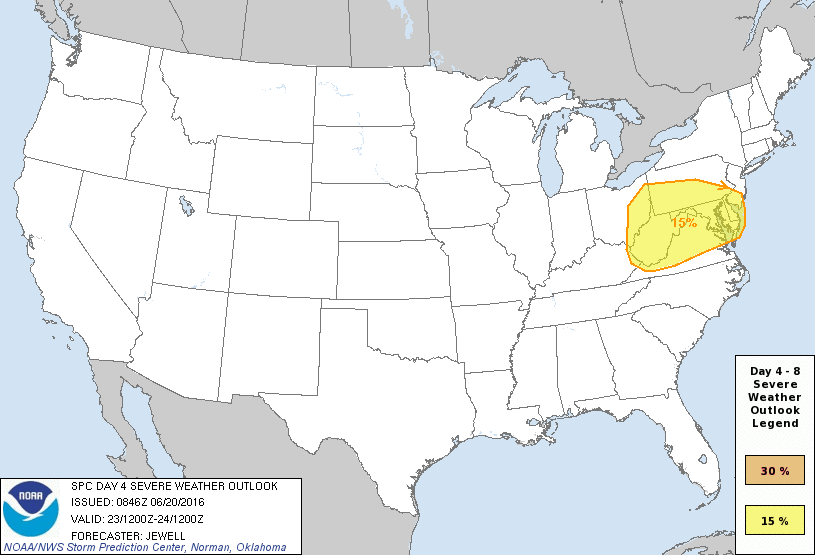
Severe Threat Thursday
...DISCUSSION...
   ON THU/D4...NUMEROUS THUNDERSTORMS...POSSIBLY AN ONGOING MCS...MAY
   EXIST ACROSS OH OR WV THU MORNING...WITH EXACT LOCATION DEPENDING ON
   THE EVOLUTION OF STORMS ON THE PREVIOUS DAY. DESPITE
   UNCERTAINTY...STRONG WLY FLOW WILL BRING A MOIST AND UNSTABLE AIR
   MASS INTO THE REGION AND TO THE ATLANTIC COAST BY MIDDAY. STRONG
   FORCING FOR ASCENT WITH A SFC LOW AND COOLING ALOFT WILL SUPPORT A
   CONTINUATION OF ANY ONGOING ACTIVITY...AND POSSIBLE REDEVELOPMENT
   ESPECIALLY ON SWRN FRINGE WHERE ACCESS TO A MORE PRISTINE AIR MASS
   IS MOST LIKELY. STRONG MEAN WIND FIELDS AND FAVORABLE LIFT WILL BE
   SUPPORTIVE OF DAMAGING WINDS. WILL INTRODUCE A BROAD 15% SLIGHT RISK
   AREA NOW THAT MODELS ARE IN BETTER AGREEMENT WITH THE UPPER
   SHORTWAVE TROUGH AND SFC LOW TRACK.

   ON FRI/D5...ANOTHER STRONG SHORTWAVE TROUGH WILL MOVE INTO THE NRN
   ROCKIES...WITH UPPER RIDGE AXIS SHIFTING EWD TOWARD THE UPPER MS
   VALLEY. MAINLY NOCTURNAL THUNDERSTORMS ARE EXPECTED FRIDAY NIGHT
   ACROSS PARTS OF THE NRN PLAINS AND UPPER MS VALLEY COINCIDENT WITH
   STRONG WARM ADVECTION AND AN APPROACHING COLD FRONT. A BETTER SEVERE
   THREAT MAY EXIST INTO SAT/D6 ACROSS PARTS OF THE MO/UPPER MS VALLEY
   REGION AS THE LOW AND COLD FRONT MATURE...AND A LESSER SEVERE THREAT
   THE NEXT DAY INTO THE OH VALLEY AREA. HOWEVER...PREDICTABILITY IS
   CURRENTLY LOW FOR THIS SYSTEM.
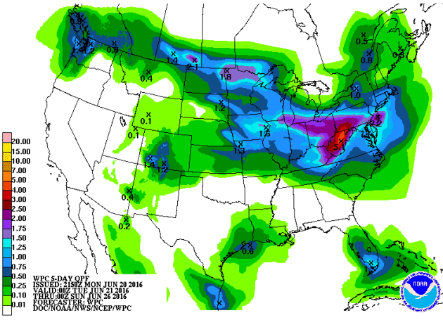
5 Day Rainfall Potential
Here's
the 5 day rainfall forecast through the end of the week, which shows
heavy rainfall potential from parts of the Midwest to the Ohio Valley
with numerous shower and thunderstorm chances through the week ahead.
"Waterspout at Pontchartrain Beach"
NEW
ORLEANS – A group of locals on Pontchartrain Beach had a few scary
moments Sunday when they got caught in the path of an apparent
waterspout.
Geremy Stovall, who took the footage on his cell phone, sent the video in to WWL-TV.
He said it happened on the south shore near the University of New Orleans just before noon.
Although Stovall was directly in the path of the spout, he said no one was injured.
Although waterspouts are generally weaker than tornados, they can be dangerous to boaters because of high winds.
See the full video from WWLTV.com HERE:

___________________________________
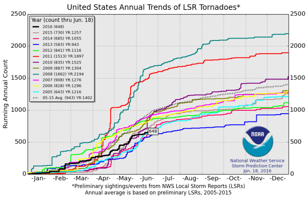
National Tornado Count for 2016
According
to NOAA's SPC, the PRELIMINARY tornado count for 2016 (thru June 18th)
is 648, which is nearly 300 reports lower than the 2005 to 2015 average.
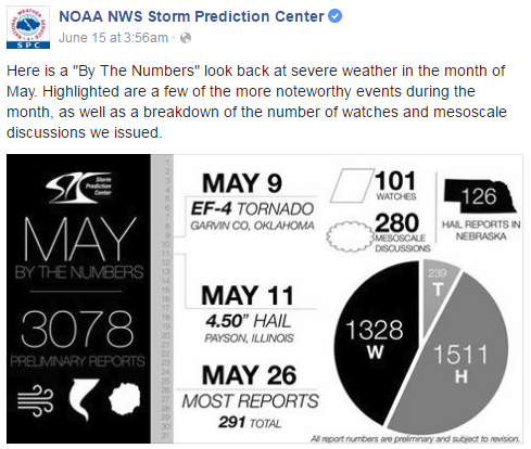
May Severe Weather
May,
on average, sees the most tornadoes out of any other month across the
nation, averaging 276. Here's a look at the severe weather numbers
across the nation for May 2016, which saw 239 tornado reports.
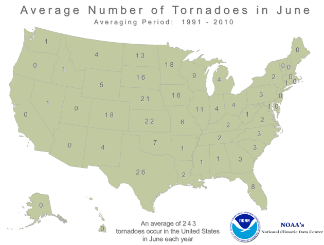
Average Tornadoes in June
While
May, on average, sees the most tornadoes across the nation, June is
typically the most active tornado month is Minnesota, averaging 18.
Interestingly, The yearly average tornado count is 45.
June Tornadoes in Minnesota
According
to NOAA's SPC, there have been 19 tornadoes in Minnesota so far this
month, most of which happened on Tuesday, June 20th.
__________________________________
"U.K. Vote on Whether to Leave Europe Imperils Global Climate"
"When British voters go to the polls Thursday to decide whether or not to withdraw from the European Union they may also be determining the fate of their country's climate legacy and its burgeoning green technology industry. That's because if the United Kingdom exits the European Union following next week's referendum it will go from being a dominant voice and second-largest economy in the 28-nation compact to being an outsider. As such, it will have to negotiate with Brussels for access to the European Union's consumer and energy markets—a situation that opponents say will give the United Kingdom less power over its own destiny than it currently has. "As Obama told them very clearly, you're going to be a midsized economy in the middle of the Atlantic, and you're not going to have the leverage you had as the 28 when you're a one," said Michelle Egan of the Woodrow Wilson International Center for Scholars. "And I don't think they realize that the other 27 have no reason to be nice in the negotiation.""
Read more from ScientificAmerican.com HERE:
If the United Kingdom exits the European Union following next week's referendum it will go from being a dominant voice and second-largest economy in the 28-nation compact to being an outsider. Credit: Michael Tubi/Corbis via Getty Images

_________________________________________"Shattered records show climate change is an emergency today, scientists warn"
"Unprecedented temperature levels mean more heatwaves, flooding, wildfires and hurricanes as experts say global warming is here and affecting us now May was the 13th month in a row to break temperature records according tofigures published this week that are the latest in 2016’s string of incredible climate records which scientists have described as a bombshell and an emergency. The series of smashed global records, particularly the extraordinary heat in February and March, has provoked a stunned reaction from climate scientists, who are warning that climate change has reached unprecedented levels and is no longer only a threat for the future. Alongside the soaring temperatures, other records have tumbled around the world, from vanishing Arctic sea ice to a searing drought in India and the vast bleaching of the Great Barrier Reef. The UK has experienced record flooding that has devastated communities across the country and scientists predict that the flash floods seen by parts of the country in recent days will increase in future."
Read more from TheGuardian.com HERE:
Flooding in Straiton, Scotland, in December. Scientists say it will increase in future. Photograph: Danny Lawson/PA

_________________________________________"12,000 Years Ago, Humans and Climate Change Made a Deadly Team"
"Climate change, habitat destruction, extinctions — the Earth has seen it all before, thousands of years ago. And humans may have been partly to blame for many of those changes in nature, too. A new study published Friday in Science Advances shows that the arrival of humans in Patagonia, combined with a changing climate, led to the extinction of many species of megafauna about 12,000 years ago in the southern portion of what is now South America. The research offers a significant moment in the natural history of the continent: a definitive date of the mass extinction of megafauna — large or giant animals, like mammoths and giant sloths — in this part of the world. It also suggests a potential relationship between threatened species and climate change in our own time. The authors of the study from the University of Adelaide in Australia, with help from scientists from South America and elsewhere, found that the presence of humans in Patagonia was not enough to drive extinction, but the one-two punch of humans and a warmer climate led to the collapse of many species."
Read more from NYTimes.com HERE:
"An illustration from the 19th century of a giant ground sloth, which was among the many megafaunal species that went extinct in Patagonia during a rapid warming phase that followed the Antarctic Cold Reversal. Researchers found that the combination of human encroachment with the warming contributed to the extinctions. CreditScience Source"

"When British voters go to the polls Thursday to decide whether or not to withdraw from the European Union they may also be determining the fate of their country's climate legacy and its burgeoning green technology industry. That's because if the United Kingdom exits the European Union following next week's referendum it will go from being a dominant voice and second-largest economy in the 28-nation compact to being an outsider. As such, it will have to negotiate with Brussels for access to the European Union's consumer and energy markets—a situation that opponents say will give the United Kingdom less power over its own destiny than it currently has. "As Obama told them very clearly, you're going to be a midsized economy in the middle of the Atlantic, and you're not going to have the leverage you had as the 28 when you're a one," said Michelle Egan of the Woodrow Wilson International Center for Scholars. "And I don't think they realize that the other 27 have no reason to be nice in the negotiation.""
Read more from ScientificAmerican.com HERE:
If the United Kingdom exits the European Union following next week's referendum it will go from being a dominant voice and second-largest economy in the 28-nation compact to being an outsider. Credit: Michael Tubi/Corbis via Getty Images
_________________________________________"Shattered records show climate change is an emergency today, scientists warn"
"Unprecedented temperature levels mean more heatwaves, flooding, wildfires and hurricanes as experts say global warming is here and affecting us now May was the 13th month in a row to break temperature records according tofigures published this week that are the latest in 2016’s string of incredible climate records which scientists have described as a bombshell and an emergency. The series of smashed global records, particularly the extraordinary heat in February and March, has provoked a stunned reaction from climate scientists, who are warning that climate change has reached unprecedented levels and is no longer only a threat for the future. Alongside the soaring temperatures, other records have tumbled around the world, from vanishing Arctic sea ice to a searing drought in India and the vast bleaching of the Great Barrier Reef. The UK has experienced record flooding that has devastated communities across the country and scientists predict that the flash floods seen by parts of the country in recent days will increase in future."
Read more from TheGuardian.com HERE:
Flooding in Straiton, Scotland, in December. Scientists say it will increase in future. Photograph: Danny Lawson/PA
_________________________________________"12,000 Years Ago, Humans and Climate Change Made a Deadly Team"
"Climate change, habitat destruction, extinctions — the Earth has seen it all before, thousands of years ago. And humans may have been partly to blame for many of those changes in nature, too. A new study published Friday in Science Advances shows that the arrival of humans in Patagonia, combined with a changing climate, led to the extinction of many species of megafauna about 12,000 years ago in the southern portion of what is now South America. The research offers a significant moment in the natural history of the continent: a definitive date of the mass extinction of megafauna — large or giant animals, like mammoths and giant sloths — in this part of the world. It also suggests a potential relationship between threatened species and climate change in our own time. The authors of the study from the University of Adelaide in Australia, with help from scientists from South America and elsewhere, found that the presence of humans in Patagonia was not enough to drive extinction, but the one-two punch of humans and a warmer climate led to the collapse of many species."
Read more from NYTimes.com HERE:
"An illustration from the 19th century of a giant ground sloth, which was among the many megafaunal species that went extinct in Patagonia during a rapid warming phase that followed the Antarctic Cold Reversal. Researchers found that the combination of human encroachment with the warming contributed to the extinctions. CreditScience Source"
__________________________________________
Thanks for checking in and don't forget to follow me on Twitter @TNelsonWX

No comments:
Post a Comment