_______________________________________________
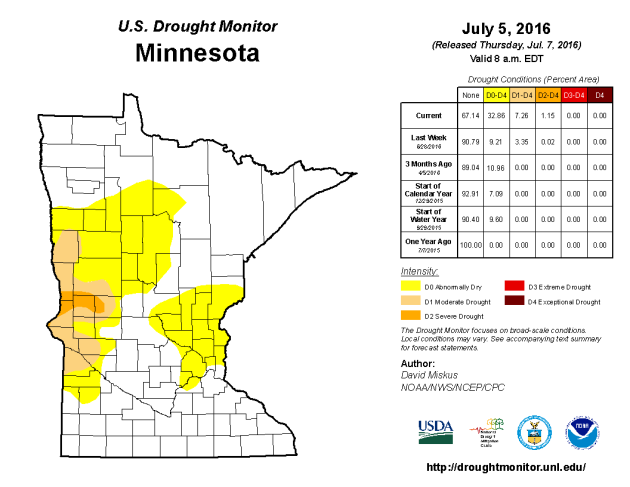
Drought Update
_______________________________________________
Another Weekend We Don't Have To Apologize For
By Paul Douglas
"To
sensible men, every day is a day of reckoning" wrote John W. Gardner.
Meteorologists get a daily report card, from the public and corporate
customers. You're only as good as your last forecast.Every day is
different, every storm is unique - today's weather is a new creation.
The elements racing overhead may resemble a previous day in history, but
it's never a carbon copy. Weather rhymes, but never repeats.
In
a day and age when we're drowning in data and weather models I find it
reassuring there's a place for intuition, gut feel and institutional
memory; all attributes computers may have trouble replicating. Then
again that may be wishful thinking.
A drying breeze punches sunny holes in our sky today but instability showers blossom north of MSP. Saturday looks stunning, with enough sunshine for 80F. Sunday will be a few degrees warmer, a notch stickier with a slight thunder risk. Temperatures flirt with 90F by early next week.
Imagine
your worst severe storm encounter. Multiply by 2 - make it last 18
hours. That's what Taiwan faces from Super Typhoon Nepartak today.
_______________________________________________
Extended Forecast for Minneapolis
FRIDAY:
Partly sunny, cooler. Isolated shower/storm, especially north. High 76.
Low 60. Chance of precipitation 20%. Winds NW 15-25 mph.
SATURDAY: Sunny with less wind. High 80. Low 64. Chance of precipitation 10%. Winds SE 7-12 mph.
SUNDAY: Less sun, risk of a T-storm. High 83. Low 70. Chance of precipitation 50%. Winds S 10-15 mph.
MONDAY: Hot, sticky sun. Strong storms late? High 89. Low 73. Chance of precipitation 60%. Winds S 10-20 mph.
TUESDAY: Clearing skies, drying out a bit. High 90. Low 71. Chance of precipitation 20%. Winds SW 8-13 mph.
WEDNESDAY: Muggy, few more T-storms. High 87. Low 67. Chance of precipitation 50%. Winds S 10-15 mph.
THURSDAY: Partly sunny, cooler, less humid. High 79. Low 60. Chance of precipitation 10%. Winds NW 10-15 mph.
_______________________________________________
This Day in Weather History
July 8th
July 8th
2002:
A three-day deluge ends in central Minnesota with 10 inches in northern
Kanabec county and 9.5 inches in southwest Aitkin County.
1974: Minnesota experiences an intense heat wave, with the Twin Cities reaching 101, the warmest temperature in 26 years.
_______________________________________________
Average Temperatures & Precipitation for Minneapolis
July 8th
July 8th
Average High: 84F (Record: 101F set in 1974)
Average Low: 64F (Record: 51F set in 1958)
Average Precipitation: 0.12" (Record: 3.07" set in 1925)
________________________________________________
Average Low: 64F (Record: 51F set in 1958)
Average Precipitation: 0.12" (Record: 3.07" set in 1925)
________________________________________________
Sunrise/Sunset Times for Minneapolis
July 8th
Sunrise: 5:35 AMJuly 8th
Sunset: 9:01 PM
*Length Of Day: 15 hours, 25 minutes and 22 seconds
*Daylight Lost Since Yesterday: ~1 mins & 13 secs
*Next Sunrise That Is Before 6 AM: August 3rd (6:01 AM)
*Next Sunset That Is Before 9 PM: July 11th (8:59 PM)
________________________________________________
Friday And Beyond Minnesota Weather Outlook
Temperatures
will be in the 70s across much of the state of Minnesota Friday,
including here in the Twin Cities. Parts of northern Minnesota will
barely reach 70, like Bemidji and International Falls.
NAM forecast precipitation and clouds every three hours between 7 AM Friday and 7 AM Saturday.
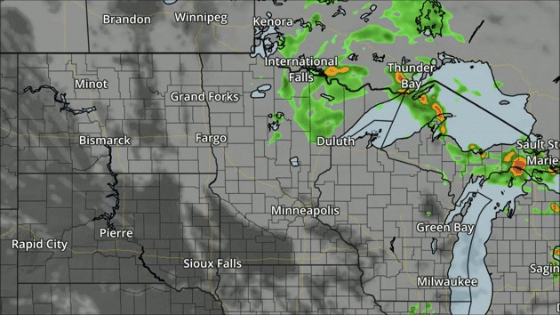
We'll
see a mix of clouds and sun throughout the day Friday across Minnesota,
with a few instability showers/storms possible during the afternoon
hours, particularly across northern Minnesota.
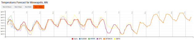
Here's a look at the temperature trends over the next several days - we'll see a warm up as we head into the weekend, with highs climbing back into the 80s. What is interesting to me is what looks to be a cool down heading into next weekend, with models currently hinting at highs only in the low to mid 70s. We'll have to see if this trend holds up.
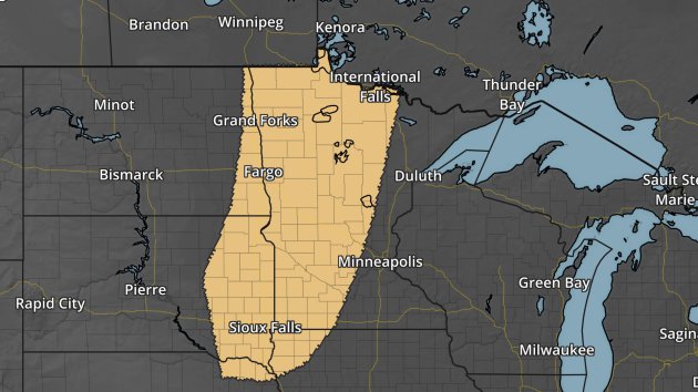
The
other story we'll be keeping an eye on isn't until next Monday across
the region, when another round of showers and storms will move through.
Some of those could be on the strong side once again, with large hail
and damaging winds possible. The Storm Prediction Center has already
highlighted an area across the western two-thirds of Minnesota where
severe weather will be possible.
________________________________________________
National Forecast Outlook And Stories
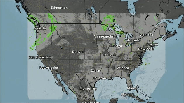
NAM forecast precipitation and clouds every three hours between 7 AM Friday and 7 AM Saturday.
A
front will bring a few showers to parts of the Northwest as we work our
way through Friday. Meanwhile, storms can be expected to pop from the
Central Plains into the Northeast.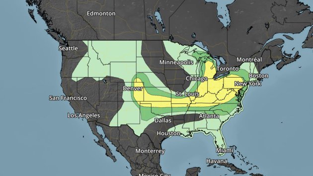
A wide area of severe weather is possible Friday from the Northeast and Great Lakes into the Front Range of the Rockies. Large hail and damaging winds will be the main threats.
Los Angeles Rain
Warnings Since 2014
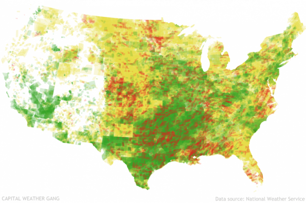
Ian Livingston of the Capital Weather Gang put together a look at warnings issued by National Weather Service offices across the nation since 2014. Click for more charts and figures of warnings that have been issued, including the elusive "zero population" warning: "As someone fascinated with the warning process and how it is communicated to the public, I have followed the severe warning accounts since inception in June 2014. Seeking out the zero warning, or one with no ambient population, is actually something of a hobby. (I know, don’t judge.) Looking for more, I made a data request on what has been issued since the Twitter accounts became operational. I was fortunate enough to connect up with the National Weather Service, and they supplied the raw data they’ve obtained while developing these channels."
________________________________________________
Thanks for checking in and have a great Friday! Don't forget you can follow me on Twitter (@dkayserwx) or on Facebook (Meteorologist D.J. Kayser)!-D.J. Kayser

No comments:
Post a Comment