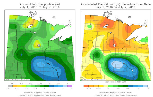
Here's more on some of the heavy rain that fell during the first week of July from Mark Seeley's WeatherTalk Blog: "Rainfall amounts from these storms were highly variable, with the largest amounts reported across a swath from west-central Minnesota through the Twin Cities Metro Area, and southeastern counties. Many observers recorded over 2 inches, and some reported new record daily amounts for July 5th, including: 4.51 at Morris, 2.14 at Artichoke Lake, and 1.77 at Moose Lake. Then on the July 6th Waseca reported a record 3.03 inches of rain,and on July 7th Park Rapids reported a new record daily rainfall of 2.11 inches. In many cases these record or near-record rainfalls were confined to narrow geographic areas by the size of the thunderstorm cells and their speed of movement."
_______________________________________________
90 Degree Day So Far This Year
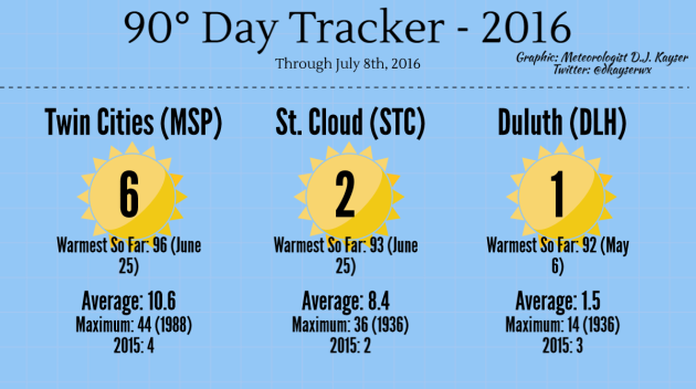
We
have hit 90 six times so far this summer here in the Twin Cities,
already blowing away the total number of 90s we had last year (four).
The warmest day we've seen was 96 back on June 25. Are there any more
90s in our near future? Your forecast is below!
_______________________________________________
Teetering on the Northern Edge of a Heat WaveBy Paul Douglas
"Ah, summer, what power you have to make us suffer and like it" wrote Russel Baker. The reality: there hasn't been too much suffering this summer: 6 days at or above 90F so far at MSP. A few muggy days, but just quick glimpses of the Sriracha-heat gripping much of the south and west.
Looking at climate data since 1884 the hottest day of the year is, historically, July 13 or 14. That's the case across much of the Upper Midwest. Why does the hottest weather come 3-4 weeks after the Summer Solstice? There's a definable, repeatable "lag" in the atmosphere, because lakes and oceans take longer to warm than land.
Winds ease today with enough sun for 80 degrees. Dew points hold in the 50s; another faint whiff of September. Southerly winds push temperatures well into the 80s Sunday into Tuesday, but long range models show comfortable 70s returning late next week.
Much of America would welcome Canadian relief. According to NOAA June was the warmest on record for the Lower 48, in spite of a lack of El Nino warming of the Pacific. 2016 is on track to be the hottest on record.
_______________________________________________
Extended Forecast for Minneapolis
SATURDAY: Sunny and pleasant. High 80. Low 65. Chance of precipitation 0%. Winds SE 5-10 mph.
SUNDAY: Partly sunny, noticeable humidity. High 86. Low 70. Chance of precipitation 10%. Winds S 10-20 mph.
MONDAY: Hot, sweaty sun. T-storms late. High 90. Low 71. Chance of precipitation 60%. Winds S 10-20 mph.
TUESDAY: Sunnier, drier - still very warm. High 88. Low 68. Chance of precipitation 10%. Winds SW 8-13 mph.
WEDNESDAY: Some sun, risk of a T-storm. High 86. Low 67. Chance of precipitation 40%. Winds NW 5-10 mph.
THURSDAY: Fading sun, more storms arrive late. High 83. Low 64. Chance of precipitation 40%. Winds SE 5-10 mph.
FRIDAY: Cooler, showery up north. High 78. Low 61. Chance of precipitation 30%. Winds NW 10-15 mph.
_______________________________________________
This Day in Weather History
July 9th
July 9th
1932: A tornado touches down near Springfield and moves into St. James, causing 500 thousand dollars in damage.
_______________________________________________
Average Temperatures & Precipitation for Minneapolis
July 9th
Average High: 84F (Record: 99F set in 1976)
Average Low: 64F (Record: 48F set in 1895)
Average Precipitation: 0.14" (Record: 2.55" set in 2000)
________________________________________________
Sunrise/Sunset Times for Minneapolis
July 9th
Sunrise: 5:36 AM
Sunset: 9:00 PM
*Length Of Day: 15 hours, 24 minutes and 05 seconds
*Daylight Lost Since Yesterday: ~1 mins & 17 secs
*Next Sunrise That Is Before 6 AM: August 3rd (6:01 AM)
*Next Sunset That Is Before 9 PM: July 11th (8:59 PM)
________________________________________________
Saturday And Beyond Minnesota Weather Outlook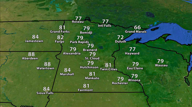
Temperatures will warm into the low 80s today across the Twin Cities, with temperatures around 80 common statewide.
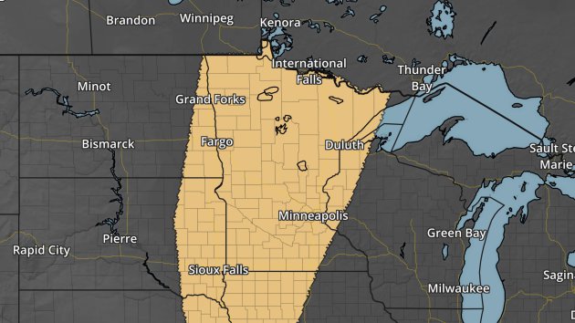
NAM forecast precipitation and clouds every three hours between 7 AM Saturday and 7 AM Sunday.
While
we could see a few passing clouds Saturday, skies will be mainly sunny
across the state. A few showers/storms will be possible Saturday Night
into Sunday morning across the region, especially in northern Minnesota.
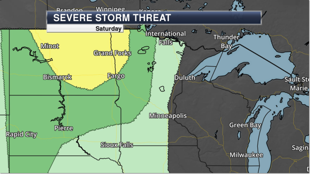
Severe risk Saturday. Dark green - marginal threat. Yellow - slight threat.
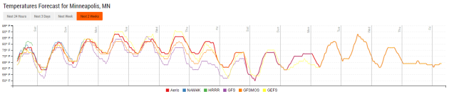
Temperatures will be on the rise as we head into the weekend, climbing into the mid 80s by Sunday. We'll remain around average over the next several days, before the models continue to hint at a possible cool down late next week.
Our
next big storm chance across the Twin Cities will be Monday, with a
warm front lifting north and cold front sliding in from the west. Right
now the models are showing a good set up for the potential of severe
storms during the afternoon and evening hours Monday, including large
hail, damaging winds and some tornadoes. We'll keep an eye on this as we
head through the weekend.
________________________________________________
National Forecast Outlook
NAM forecast precipitation and clouds every three hours between 7 AM Saturday and 7 AM Sunday.
We'll
be watching the potential for storms across parts of the Northeast as
well as the Northern and Central Plains Saturday, with some showers
across the Northwest.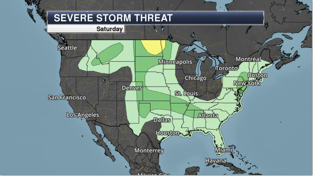
Large hail and damaging winds will be the main concerns with any storms that go severe across the country Saturday. There are a few areas where severe storms may be possible, but the best chance of seeing any severe weather will be across parts of North Dakota and extreme northwest Minnesota.
________________________________________________
Thanks for checking in and have a great Saturday! Don't forget you can follow me on Twitter (@dkayserwx) or on Facebook (Meteorologist D.J. Kayser)!-D.J. Kayser

No comments:
Post a Comment