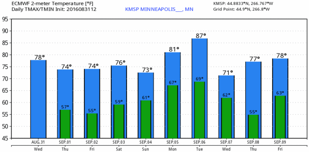
78 F. average high on August 31.
86 F. high on August 31, 2015
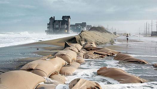
September 1, 1926: Perhaps the most intense rainfall rate ever in downtown Minneapolis falls on this date. 1.02 inches of rain is recorded in six minutes, starting at 2:59pm in the afternoon according to the Minneapolis Weather Bureau. The deluge, accompanied with winds of 42 mph, causes visibility to be reduced to a few feet at times and stops all streetcar and automobile traffic. At the intersection of Second and Sixth Streets in downtown Minneapolis, rushing water tears a manhole cover off, and a geyser of water shoots 20 feet in the air. Hundreds of wooden paving blocks are uprooted and float onto neighboring lawns, much to the delight of barefooted children seen scampering among the blocks after the rain ends.
September 1, 1894: The Great Hinckley Fire. Drought conditions start a massive fire that begins near Mille Lacs and spreads to the east. The firestorm destroys Hinckley and Sandstone and burns a forest area the size of the Twin Cities Metropolitan Area. Smoke from the fires brings shipping on Lake Superior to a standstill.
September 1, 1807: The earliest known comprehensive Minnesota weather record begins near Pembina. The temperature at midday is 86 degrees, with a 'strong wind until sunset.'
Dry Into Saturday - Tracking Storms With Names
"We know that in September we will wander through the warm winds of summer's wreckage. We will welcome summer's ghost" wrote Henry Rollins. Ah September: prime time for foggy mornings and raging hurricanes.
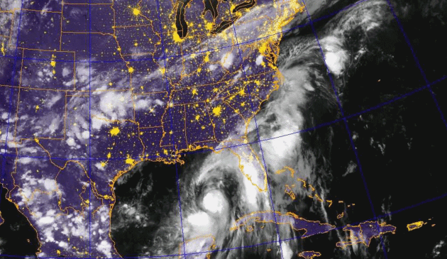
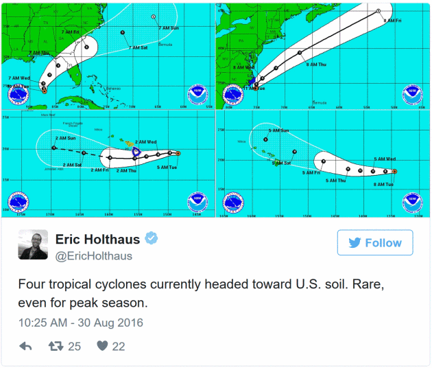
Right now 4 different tropical systems are threatening the USA, including 2 hurricanes steamrolling toward the Big Island of Hawaii. Waters were once too chilly to support hurricanes in Hawaii, but that is changing as oceans warm.
A tropical storm forecast to hit the Florida Panhandle may track up the east coast this weekend; inland flash flooding possible from the Carolinas to Washington D.C. and New York City by Sunday.
Hurricane season peaks September 11, the date these pinwheels of trouble are most likely to make landfall, coinciding with peak water temperatures.
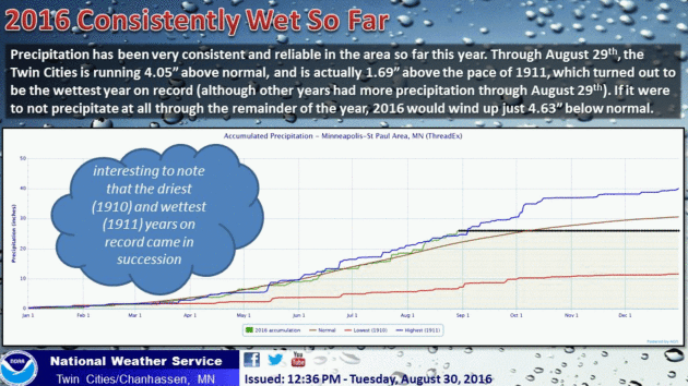
Nearly 8 inches of rain soaked the Twin Cities in August; 2016 is now on track to be one of the wettest years on record for much of Minnesota. Dry, comfortable weather lingers into Saturday, but we fall back into a wet rut next week. A series of storms may squeeze out 2-3 inches of rain in the next 2 weeks.
The map looks more like June 1 than September 1.
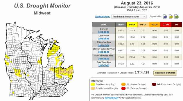
Kevin Hawkins asks:
"I noticed that the DNR shows no drought conditions anywhere in Minnesota right now. Is that unusual for this time of the year? It seems like it has been many years since that has happened."
Pete Boulay, at the Minnesota DNR and State Climatology Office answers:
We actually still have a very small area of "abnormally dry" or D0 designation still in far southwestern Minnesota O.K. it covers .13% of the state
https://www.drought.gov/
"Below the map of Minnesota is a neat table that shows the percentage of drought coverage in the past. The last time Minnesota was free of any drought was back in July 2015, with a longer stretch after the really wet June 2014. Thus for the last couple of years we have had spells during the summer that have been drought free. The last time there was extreme drought (D3) in Minnesota was 2013. The last time there was exceptional drought (D4) in Minnesota was in the 1988 drought."
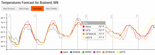
Best Lake Day: Saturday.
Guidance continues to show fading sun, a stiff south breeze and highs
well up into the 70s as far north as the Brainerd Lakes area Saturday.
Sunday and Monday? Not so much.
Labor Day: Shot at 80+ In The Metro.
The approach of a warm front will spark a warming trend by Monday (and
more humidity sparking a few random T-storms as well). No monster cold
fronts brewing anytime soon. MSP Meteogram: WeatherBell.

Dry Into Saturday - Another Soaking Next Week?
GFS guidance (and ensembles) hint at a couple inches of rain next week
for much of Minnesota as more sloppy storms spin up overhead. June
continues. Graphic: Aeris Enterprise.


* Faint echoes of "Sandy" are ringing in my head - and although "Hermine" will not be as bad as Sandy, there is a growing potential for disruptive weather all up and down the East Coast from Friday into Sunday; coastal Georgia and the Carolinas right up I-95 into Washington D.C. and New York City may be impacted by 40-60 mph winds, flash flooding and coastal flooding and beach erosion as Hermine churns north.
* Blocking high pressure system over North Atlantic will act as a temporary road block, causing Hermine to temporarily stall off the Mid Atlantic coast, prolonging a period of pounding waves and heavy inland rains Friday into Sunday.
* Although impacts are not expected to rival Sandy in 2012, this may be the rough late-summer equivalent of a very severe winter Nor'easter. Areas along the coast that normally flood will probably experience water problems (Carolinas by Friday - Mid Atlantic region by Saturday into Sunday).


We'll update you again Thursday morning with an intermediate update Thursday evening. Remember the additional risk to the Big Island of Hawaii posed by Madeline and Lester (downgraded to Tropical Storms, but still capable of flooding rains and damaging winds). Map credit above: WeatherBell.
Paul Douglas, Senior Meteorologist, Aeris Weather
Aeris Weather Briefings: Issued by D.J. Kayser Wednesday morning, August 31st, 2016
Here's an excerpt...

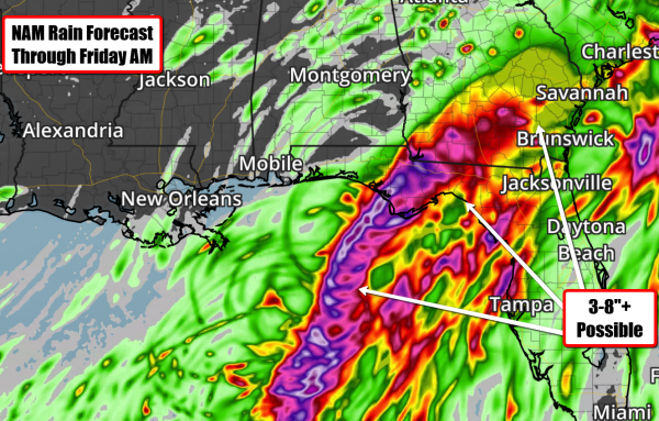 Rainfall Forecast. Potentially
the greatest concern with this system will be inland flooding, with at
least 3-8” of rain likely along the path from Florida into Georgia. Both
of the American models shown above show that potential of 3-8” of rain
over the next 60-72 hours, with higher amounts possible. If you live in
an area prone to flooding odds are you'll experience more flooding over
the next 72 hours.
Rainfall Forecast. Potentially
the greatest concern with this system will be inland flooding, with at
least 3-8” of rain likely along the path from Florida into Georgia. Both
of the American models shown above show that potential of 3-8” of rain
over the next 60-72 hours, with higher amounts possible. If you live in
an area prone to flooding odds are you'll experience more flooding over
the next 72 hours.
 Storm Surge Potential.
Flooding from storm surge will also be likely along the Big Bend of
Florida. A storm surge of at least 3-6 feet above ground is possible
mainly north of the Clearwater area, from Homosassa Springs to the
Spring Creek area.
Storm Surge Potential.
Flooding from storm surge will also be likely along the Big Bend of
Florida. A storm surge of at least 3-6 feet above ground is possible
mainly north of the Clearwater area, from Homosassa Springs to the
Spring Creek area.
 Labor Day Weekend Trouble. By late Saturday,
forecast models are showing this system off the coast of the Carolinas.
Tropical storm force winds, storm surge and heavy rain will be
possible along the Mid-Atlantic coast into the holiday weekend.
Labor Day Weekend Trouble. By late Saturday,
forecast models are showing this system off the coast of the Carolinas.
Tropical storm force winds, storm surge and heavy rain will be
possible along the Mid-Atlantic coast into the holiday weekend.
 Northeast Impact?
Some of the longer term models are indicating the potential of some
sort of impact from this system in parts of the Northeast late this
weekend and early next week. Uncertainty is very high right now for this
longer term forecast, but interests along the coast as far north as New
England should keep an eye on this into early next week.
Northeast Impact?
Some of the longer term models are indicating the potential of some
sort of impact from this system in parts of the Northeast late this
weekend and early next week. Uncertainty is very high right now for this
longer term forecast, but interests along the coast as far north as New
England should keep an eye on this into early next week.
 Busy In The Pacific As Well.
We also have our eye on two hurricanes in the Pacific – Madeline and
Lester – which could have an impact on the Hawaiian Islands over the
next several days.
Busy In The Pacific As Well.
We also have our eye on two hurricanes in the Pacific – Madeline and
Lester – which could have an impact on the Hawaiian Islands over the
next several days.
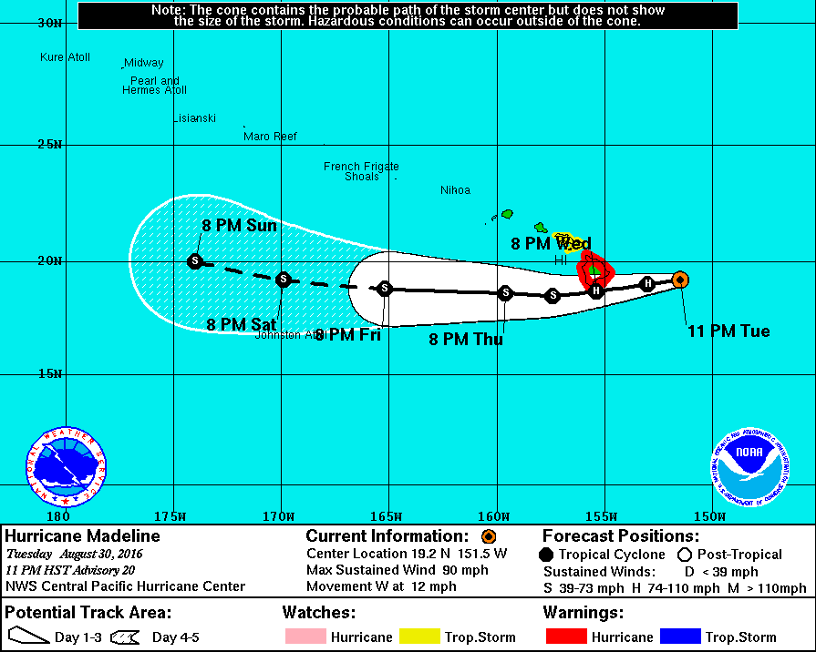 Madeline To Impact Hawaii. A
Hurricane Warning is in effect for the Big Island of Hawaii as Madeline
makes a very dangerous approach over the next 24-36 hours. This could
be a historic storm if it does make landfall on the Big Island as a
hurricane has never done so going back to when our records began (1949).
Forecast models are showing a good amount of consistency in the track
of the storm, so this will be something to watch very closely. If you
have any facilities on the Big Island, any preparations ahead of
Madeline should be quickly finished.
Madeline To Impact Hawaii. A
Hurricane Warning is in effect for the Big Island of Hawaii as Madeline
makes a very dangerous approach over the next 24-36 hours. This could
be a historic storm if it does make landfall on the Big Island as a
hurricane has never done so going back to when our records began (1949).
Forecast models are showing a good amount of consistency in the track
of the storm, so this will be something to watch very closely. If you
have any facilities on the Big Island, any preparations ahead of
Madeline should be quickly finished.
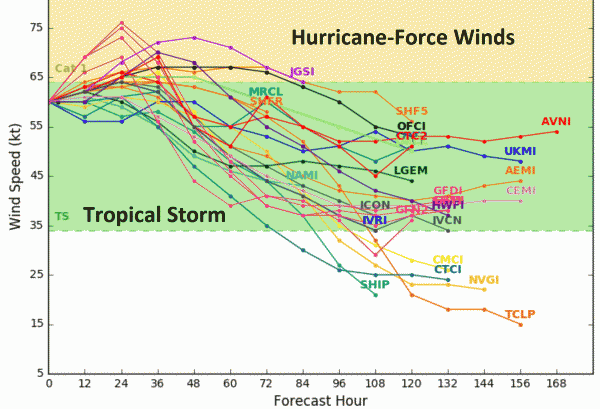
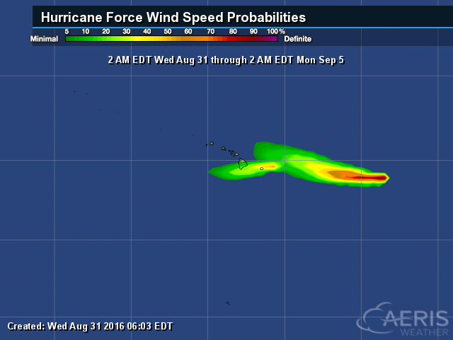 Hurricane Force Winds Possible.
Hurricane conditions (74 mph+ winds) are possible as early as this
evening (local time) across parts of the Big Island. While the
probability of hurricane force winds at Hilo is 5% and 25% at South
Point, those numbers have gone up over the past 24 hours.
Hurricane Force Winds Possible.
Hurricane conditions (74 mph+ winds) are possible as early as this
evening (local time) across parts of the Big Island. While the
probability of hurricane force winds at Hilo is 5% and 25% at South
Point, those numbers have gone up over the past 24 hours.
 Tropical Storm Force Winds.
There is a high likelihood of tropical storm force winds across the Big
Island, and about a 60% chance across Maui and Moloka’i, as this system
passes to the south in the next couple days. I would expect power
outages to occur on the islands.
Tropical Storm Force Winds.
There is a high likelihood of tropical storm force winds across the Big
Island, and about a 60% chance across Maui and Moloka’i, as this system
passes to the south in the next couple days. I would expect power
outages to occur on the islands.
 Heavy Rain And Storm Surge.
A Flash Flood Watch is in effect for the Big Island, as Madeline has
the potential to bring 5-10” of rain. Some windward areas could receive
up to 15” of rain. This may lead to flash flooding and mudslides the
next couple days. Also of concern will be storm surge, which could range
from 1-3 feet, leading to significant coastal flooding.
Heavy Rain And Storm Surge.
A Flash Flood Watch is in effect for the Big Island, as Madeline has
the potential to bring 5-10” of rain. Some windward areas could receive
up to 15” of rain. This may lead to flash flooding and mudslides the
next couple days. Also of concern will be storm surge, which could range
from 1-3 feet, leading to significant coastal flooding.
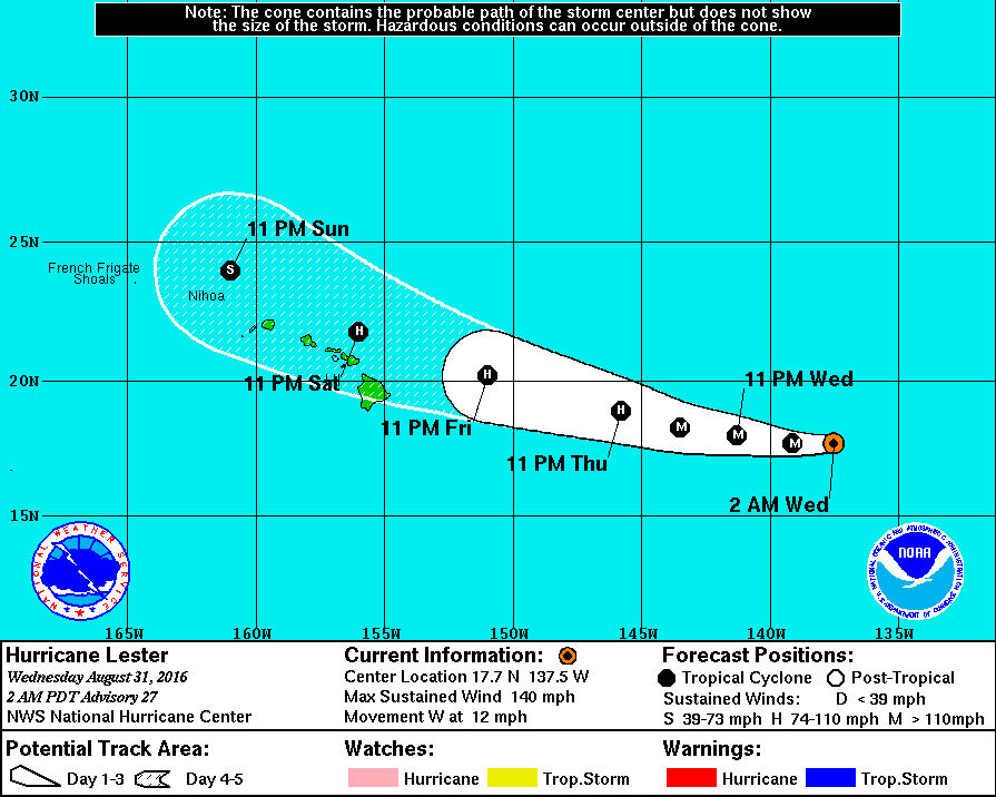 One-Two Punch?
Right behind Madeline we are watching Hurricane Lester, which is
expected to approach the Hawaiian Islands into the weekend. This storm
will once again have the potential to bring very strong winds and heavy
rain to the islands.
One-Two Punch?
Right behind Madeline we are watching Hurricane Lester, which is
expected to approach the Hawaiian Islands into the weekend. This storm
will once again have the potential to bring very strong winds and heavy
rain to the islands.
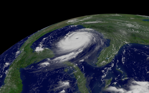
Summary: In the Lower 48, all eyes continue to be on Tropical Depression Nine in the Gulf of Mexico. This system still has the potential to strengthen into a tropical storm before making landfall sometime late Thursday/early Friday along the Florida Gulf Coast. Very heavy rain – on the order of at least 3-8” – will be possible across parts of Florida and Georgia over the next 72-96 hours as the system tracks over the region. Tropical storm force winds of 39 mph or greater will also be possible as well as storm surge of 3-6 feet or higher along the Florida Coast.
Preparations should continue across the region today, with conditions quickly deteriorating over the next 24 to 36 hours. In the Pacific, Hurricane Madeline will make a dangerous approach to the Big Island of Hawaii in the next 24 hours, bringing with it very heavy rain and the potential of hurricane force winds (74 mph or greater). Right behind that will be another system that could have an impact on the island chain into the weekend in the form of Lester. Another update on the systems Thursday morning.
Meteorologist D.J. Kayser, AerisWeather
Here's an excerpt...
Summary: In the Lower 48, all eyes continue to be on Tropical Depression Nine in the Gulf of Mexico. This system still has the potential to strengthen into a tropical storm before making landfall sometime late Thursday/early Friday along the Florida Gulf Coast. Very heavy rain – on the order of at least 3-8” – will be possible across parts of Florida and Georgia over the next 72-96 hours as the system tracks over the region. Tropical storm force winds of 39 mph or greater will also be possible as well as storm surge of 3-6 feet or higher along the Florida Coast.
Preparations should continue across the region today, with conditions quickly deteriorating over the next 24 to 36 hours. In the Pacific, Hurricane Madeline will make a dangerous approach to the Big Island of Hawaii in the next 24 hours, bringing with it very heavy rain and the potential of hurricane force winds (74 mph or greater). Right behind that will be another system that could have an impact on the island chain into the weekend in the form of Lester. Another update on the systems Thursday morning.
Meteorologist D.J. Kayser, AerisWeather
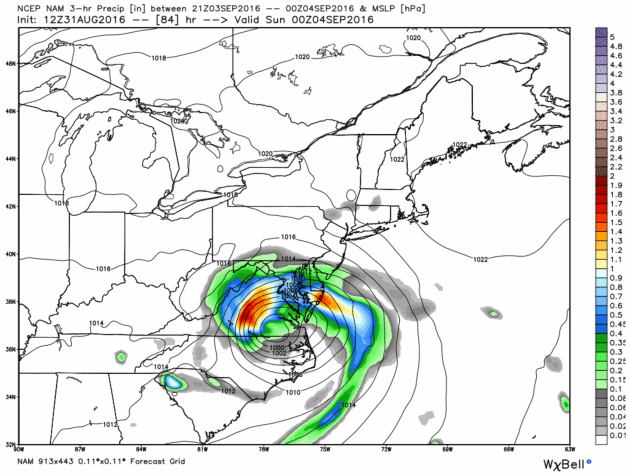
Map credit above: NAM forecast for Saturday evening, courtesy of WeatherBell.
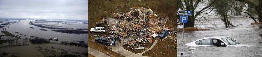
Is Your Homeowners Insurance a Disaster Waiting to Happen? Here's a clip from Forbes: "...A less expensive form of coverage is cash value coverage, which may not include the added rebuilding costs. Natural disasters, such as hurricanes and tornadoes, can cause widespread damage resulting in shortages of building materials and labor, significantly driving up the cost of rebuilding. It is a good idea to make sure your policy coverage limits are sufficiently high to account for these higher replacement costs. Your policy may also include or make available guaranteed or extended replacement cost coverage to protect against these unexpected cost increases. Read the policy and know what you own. Replacement cost and cash value mean different things in the insurance world..."


Graphic credit: "These graphs show overall U.S. energy consumption and carbon dioixde emissions by fuel through 2015 and projections for 2016." Credit: EIA

Senator Chuck Grassley: Trump Can Get Rid of Wind Energy "Over My Dead Body". Yahoo News has details: "Donald
Trump has railed against wind energy for years, but he’d face a
backlash from members of his own party if he wins the White House and
his administration pushes too hard on the issue. Sen. Chuck Grassley,
R-Iowa, the author of the original wind energy tax credit in 1992, said a
hypothetical President Trump wouldn’t be able to get rid of wind power
in the U.S. as long as he’s alive. The GOP nominee has railed for years
that wind farms are “ugly,” “obsolete” and “terrible for the
environment,” among many other criticisms. “If he wants to do away with
it, he’ll have to get a bill through Congress, and he’ll do it over my
dead body,” Grassley said Tuesday in an interview with Yahoo News..."

Placing charging stations at workplaces, where cars spend much of their time, will be uniquely powerful. When a workplace installs a charging station, employees are 20 times as likely to buy a vehicle with a plug, according to a survey from the U.S. Department of Energy.Graphic credit: "Contagion, contagion everywhere!" (Shutterstock).
In Minnesota Churches, Let There Be Light - Solar Light. Why wouldn't churches, temples and mosques take advantage of (free) solar power? Here's an excerpt from The Star Tribune: "When
the Bible quotes God declaring “Let there be light,” it wasn’t exactly
referring to solar power. But across Minnesota, there’s been an
unprecedented surge in religious congregations installing rooftop solar
panels, subscribing to off-site solar “gardens” and urging their
faithful to do the same. The most ambitious project is slated for this
fall at Shiloh Temple International Ministries in north Minneapolis,
which will build a solar garden on its roof, make energy available for
up to 40 neighbors, and be part of a solar installation job-training
program for lower-income workers..."
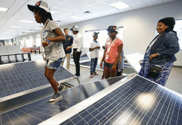
Image credit: Jerry Holt, Star Tribune. "Maniya Dorsey, 9, toured Ten K Solar in Bloomington with her church group last week."

Image credit: "A interior rendering of one of Spike Aerospace’s planes — windows would be replaced by flat panel displays showing images captured by outside cameras." Credit: Spoke Aerospace.


TODAY: Sunny and very nice. Winds: E 5-10. High: 75
THURSDAY NIGHT: Clear and comfortable. Low: 55
FRIDAY: Partly sunny, a mild breeze. Winds: S 10-15. High: 77
SATURDAY: Sunniest, driest day of the holiday weekend. Winds: S 10-20. Wake-up: 58. High: near 80
SUNDAY: A few showers and T-storms likely. Winds: S 10-20. Wake-up: 61. High: 77
LABOR DAY: Some sticky sun, another PM T-storm. Winds: SE 8-13. Wake-up: 63. High: 81
TUESDAY: What a shock: humid with more T-storms. Winds: SW 10-15. Wake-up: 65. High: 83
WEDNESDAY: Showers taper, slow clearing. Winds: NW 8-13. Wake-up: 63. High: 77
* Thanks to my friend, Pete Schenck, who snapped this photo up on Lake Ossawinnamakee yesterday.
Climate Stories...

Image credit: Ed Hawkins.

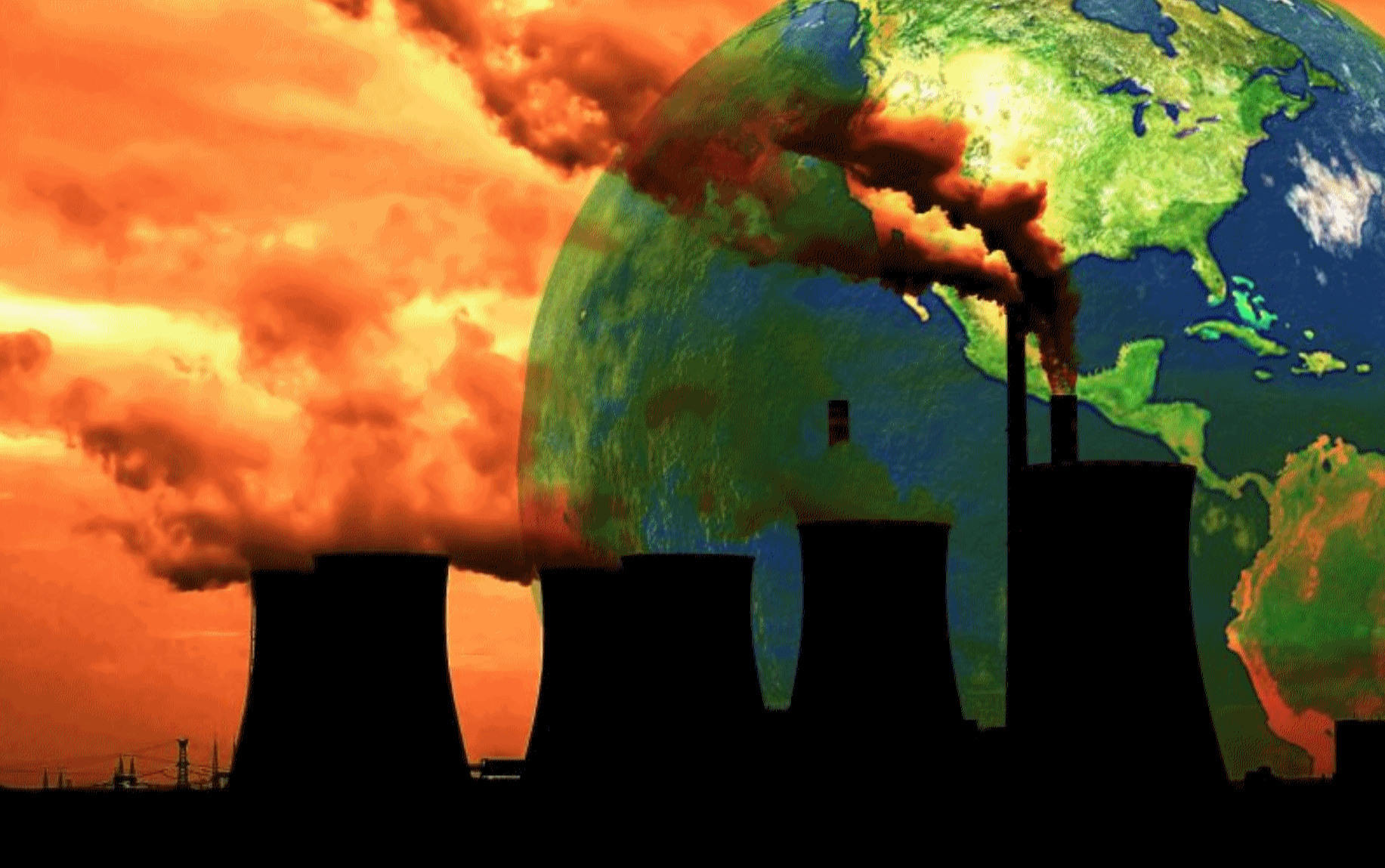
Climate Change "Mother Of All Risks" Says Aviva CEO Amid Calls to End Fossil Fuel Subsidies. Here's an excerpt from CNBC: "...Making a profit is essential in business," Mark Wilson, chief executive of Aviva, said in a media note on the Overseas Development Institute's (ODI) website. "But we will only be in business in the future if we act sustainably and create wider long term social value. That's just good business – and not acting sustainably is very bad business indeed." "Climate change in particular represents the mother of all risks – to business and to society as a whole," Wilson added. "And that risk is magnified by the way in which fossil fuel subsidies distort the energy market. These subsidies are simply unsustainable..."

Photo credit: "US
Forest Service crew members Paris Krause and Michael DeNicola walk along
a high intensity burn area (mostly dead Jeffrey pines and White firs)
one year after the Lake Fire in the San Bernardino National Forest on
Wednesday, July 20, 2016." Susanica Tam for KPCC.

Graphic: NASA Earth Observatory.
The "Social Cost of Carbon" Is The Most Historic Climate Change Decision Yet. The Daily Beast has details: "One of the most significant court cases about climate change was decided earlier this month by a federal appeals court in Chicago. Given that it was steeped in the enervating context of refrigerator regulations, you may have missed it. But amid the stultifying discussions of compressors and insulation foam was a crucial advance in our nation’s belated attempts to forestall global climate catastrophe. It all comes down to a new phrase: the Social Cost of Carbon. Here’s why it’s important. By law, government agencies—in this case, the Department of Energy—are often required to show that the benefits of a proposed regulation exceed the costs..."
Illustration credit: Kelly Caminero/The Daily Beast.

The Challenge of Cutting Coal Dependence. The New York Times reports: "It
won’t be easy to get rid of coal. Worried the nation might miss its
2020 target to drastically cut emissions of carbon dioxide, the German
government proposed a steep levy last year on the most heavily polluting
generators. The tax was intended to deliver a decisive blow against
lignite or brown coal, the dirtiest fuel around and Germany’s main
source of electricity. Germany views itself as a leader in the push
against climate change.
It is probably the world’s most enthusiastic investor in renewable
energy, mainly wind and sun. But even the powerful Chancellor Angela
Merkel couldn’t quite pull it off..."
Do you drink Pepsi or Coca-Cola?
ReplyDeletePARTICIPATE IN THE POLL and you could get a prepaid VISA gift card!