Fall Color Update - MN DNR
This is always a fun map to drag out around this time of the year! According to the MN DNR, there are already a few locations that are at 10 - 25% color, mainly across central and northern Minnesota. Keep an eye out for gradually changing fall foliage over the next several weeks. It's interesting that when at/past peak occurs, the leaves seem to drop VERY rapidly, so don't blink!

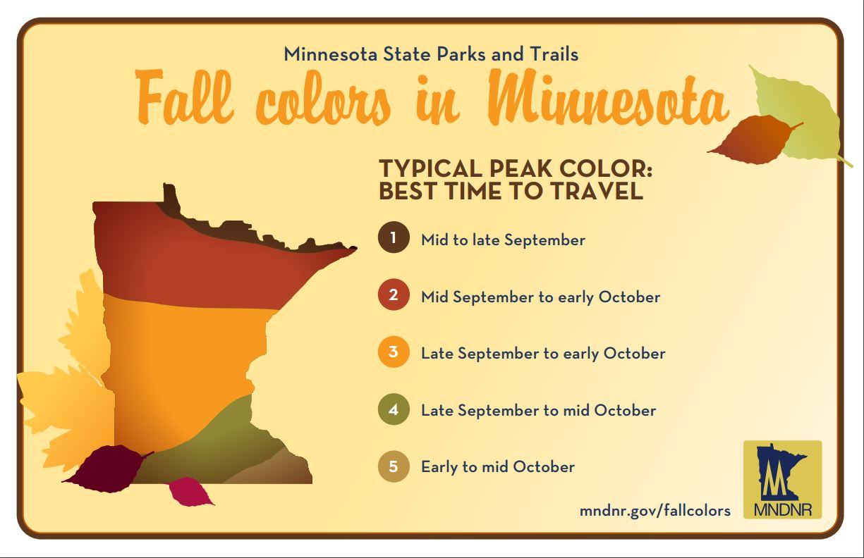
Average Peak Color
According to the MN DNR, the typical peak color across the state is as advertised in the graphic below. Note that peak color is as early as mid-late September across the far northern part of the state to as late as early-mid October across the southern part of the state. The Twin Cities usually starts to peak around late September to mid October.
What Causes Fall Color?
Here's a neat article from the MN DNR on what causes fall color:
"The chemicals"
"Four main groups of biochemicals are responsible for the various yellows, oranges, reds and browns that we see in the fall:
Chlorophyll
Carotenoids
Anthocyanins
Tannins
Carotenoids
Anthocyanins
Tannins
Each has its own color and chemistry. As the amount of these chemicals vary, they will cause subtle variations in color from one leaf to the next, or even from tree to tree."
___________________________________________________
A Touch of Fall This Weekend - 60s Next Week
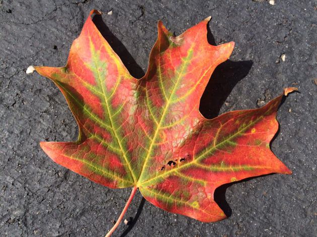
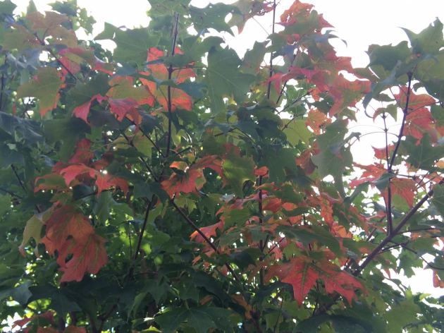
Is it just me or are there a few trees that are already starting to change color? Driving around town, I've noticed a few ambitious ones getting a quick jump on the fall this year. Did they not get the memo that average peak in the Twin Cities is late September to mid October?
According to the MN DNR, there are already a few locations around the state reporting 10 to 25 percent color, mainly across central and northern Minnesota. With that said, enjoy a gradual burst of fall foliage over the next several weeks as cooler nights and dwindling daylight lures your favorite neighborhood tree to sleep.
Post-front today, we dry out and cool down. A noticeable breeze brings a touch of Fall to the air this weekend. Clear skies, dry air and light winds could allow some of the normal cool spots up north to dip into the 30s Sunday morning. Another cold front arrives Monday with high temps falling into the 60s Tuesday and Wednesday, nearly 10 to 15 degrees below average.
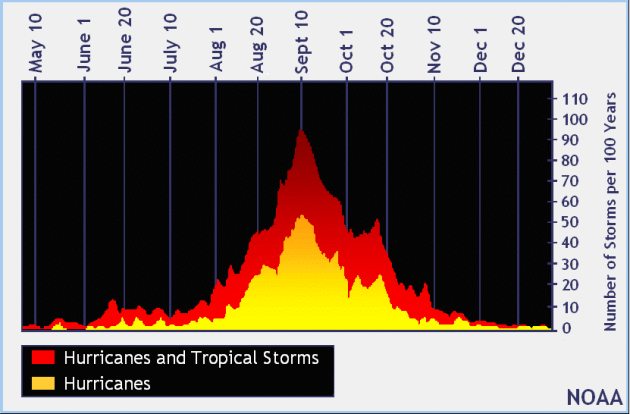
By the way, today is the peak of Atlantic Hurricane Season.
____________________________________________________
____________________________________________________
Extended Weather Outlook
FRIDAY NIGHT: Showers taper, cooler breeze kicks in. Winds: WNW 5. Low: 56.
SATURDAY: Partly sunny, cool breeze. Winds: NW 10-15. High: 69
SATURDAY NIGHT: Mostly clear and cool. Winds: W 5-10. Low: 55
SUNDAY: Sunnier and milder. Better lake day. Winds: SSW 15-20. High: 77
MONDAY: Passing sprinkle, turning cooler. Winds: NNW 5-10. Wake-up: 59. High: 72
TUESDAY: Feels like early October, PM sun. Winds: NNE 5-10. Wake-up: 52. High: 65
WEDNESDAY: Chilly start. Cool afternoon sunshine. Winds: SSE 5-10. Wake-up: 48. High: 67
THURSDAY: Not as chilly, clouds thicken late. Winds: S 5-15. Wake-up: 53. High: 72
FRIDAY: Mostly cloudy with spotty storms. Winds: SE 10-15. Wake-up: 56. High: 73.
_______________________________
_______________________________
This Day in Weather History
September 10th
September 10th
2002: A late-season tornado strikes Albertville just after midnight .According to a damage survey conducted by NWS personnel, it touched down on the eastern edge of Cedar Creek Golf Course, then it moved straight east and dissipated in a city park just west of the railroad tracks. It completely tore the roof off of one home. Roofs were partially off a number of other homes, many attached garages collapsed, and a couple of houses were rotated on their foundation. About 20 homes were damaged, nine of which sustained significant damage.
1986: 3 inch hail falls in Watonwan County.
1947: Downpours fall across the Iron Range. Hibbing receives 8.6 inches in three hours.
1931: St Cloud experiences a record high of 106 degrees, and it reaches 104 degrees in Minneapolis.
1910: The shortest growing season on record in Duluth ends, with frost free days from June 14 to September 10 (87 days). Normally the frost-free season is 143 days.
________________________________
________________________________
Average High/Low for Minneapolis
September 10th
September 10th
Average High: 74F (Record: 104F set in 1931)
Average Low: 55F (Record: 37F set in 1917)
_________________________________
Average Low: 55F (Record: 37F set in 1917)
_________________________________
Sunrise/Sunset Times for Minneapolis
September 10th
September 10th
Sunrise: 6:46am
Sunset: 7:32pm
Sunset: 7:32pm
*Daylight Lost Since Yesterday: ~3mins & 4sec
*Daylight Lost Since Summer Solstice: ~2hours and 50mins
__________________________________
*Daylight Lost Since Summer Solstice: ~2hours and 50mins
__________________________________
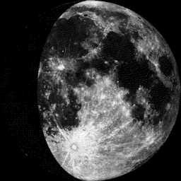
Moon Phase for September 10th at Midnight
1.8 Days Since First Quarter
1.8 Days Since First Quarter
___________________________________
Weather Outlook Saturday
High temperatures on Saturday will be a little more 'fallish' with some spots only reaching the mid-upper 60s up north. The Twin Cities will flirt with 70F with dewpoints in the upper 40s to low 50s. Interestingly, I would be surprised if some of the normal cool spots up north dip down into the 30s by Sunday morning!

Weather Outlook Saturday
Post-front Saturday will feature a fairly decent west-northwest wind at times gusting close to 20mph. This wind will help to continue to draw in cooler, drier weather for the remainder of the day. The wind switches on Sunday, however, out of the south, which will help to warm us up a bit. Some spots across southern Minnesota may reach the 80 degree mark once again.
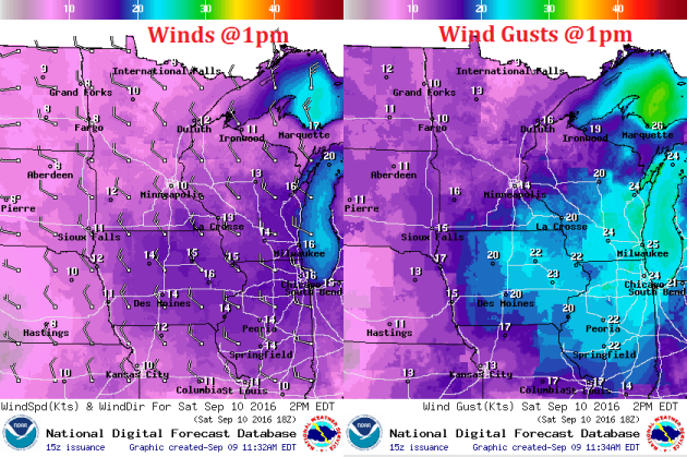
Weather Outlook Saturday
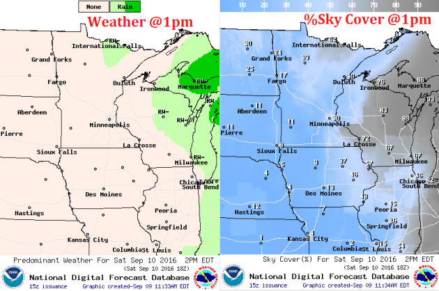
Here's the weather outlook for midday Saturday, which shows lingering clouds across the Mississippi River Valley associated with the storm system that brought us rain on Friday. Lingering clouds and showers will be present across parts of the state early Saturday, but things will begin to clear out as we head into the afternoon hours.
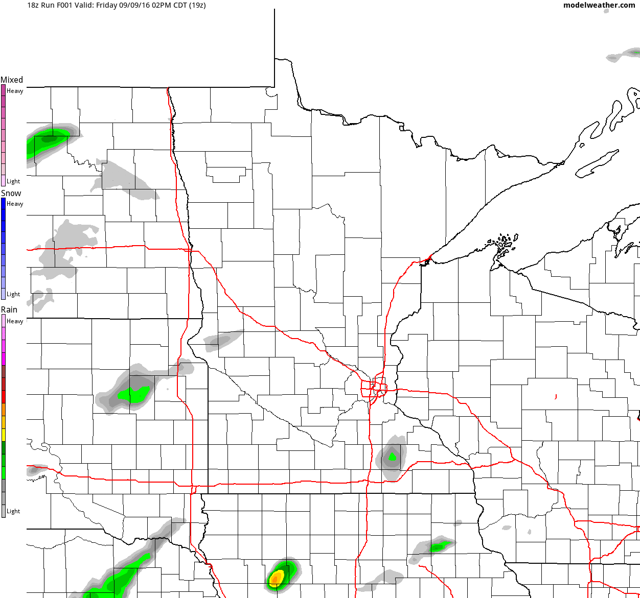
Simulated Radar
The simulated radar from PM Friday to AM Monday suggests that weather our wetter weather conditions on Friday will improve on Saturday and Sunday. Note that lingering showers seem to persist through early Saturday across parts of Wisconsin and northeastern MN, but most locations should remain dry for much of the weekend.
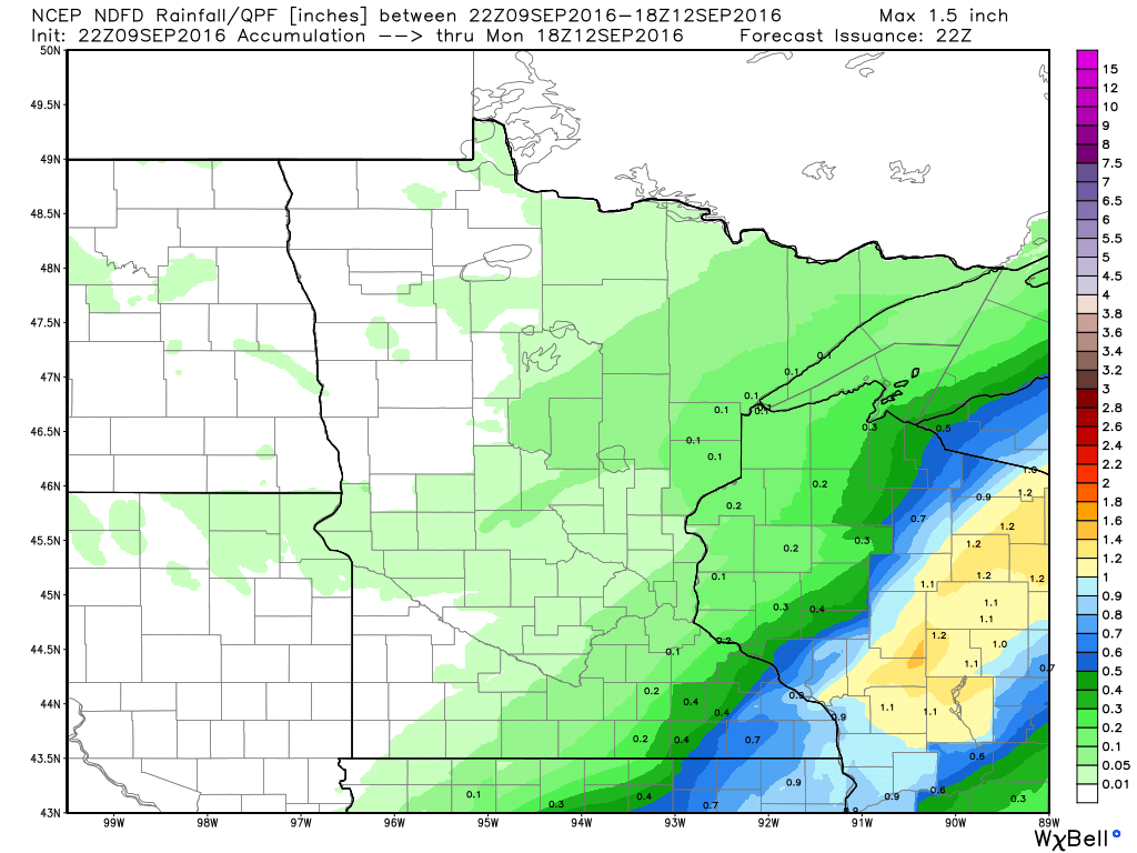
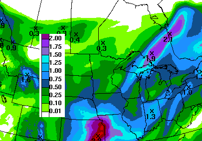
Rainfall Potential
Here's the rainfall potential through Midday Monday, which suggests the heaviest moisture from Friday into AM Saturday shifting from southeast Minnesota into central and northeastern Wisconsin. There may be a few lingering spits across northeastern Minnesota and Wisconsin early Saturday, but it should amount to much.
__________________________________________
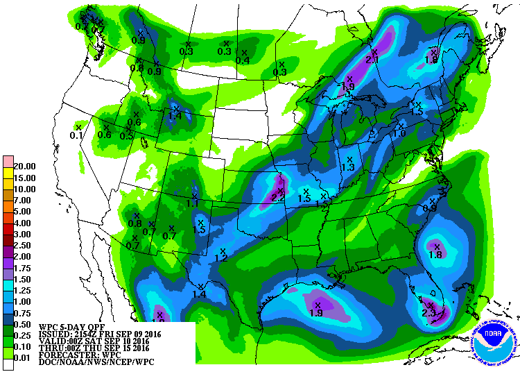
7 Day Rainfall Outlook
According to NOAA's WPC, the 7 day rainfall forecast suggests that the heaviest rainfall will shift farther south of the region as we head through the weekend. Mostly dry weather persists through much of the week until late in the when steadier showers/storms begin moving back in to the Upper Midwest.
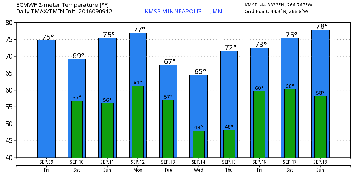
Extended Weather Outlook
The extended temperature outlook through mid September suggests near average conditions continuing throughout much of next week, however, note the 60s sprinkled in there through the middle part of next week! These days will feel more like late September/early October.
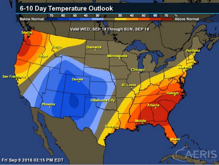
6 to 10 Day Temp Outlook
According to NOAA's CPC, the 6 to 10 day temperature outlook suggests equal chances of above and below normal temperatures from September 14th - September 18th. This will come after cooler than average temperatures settle into the region through the middle part of next week.

6 to 10 Day Temp Outlook
The national temperature outlook suggests that warmer than average temperatures will be found in the Southeast and Northwest, while cooler than average temperatures will be found in the Southwest.
___________________________________________
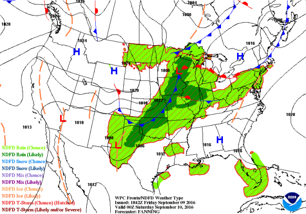
National Weather Outlook
A slow moving front responsible for scattered thunderstorms and heavy rain in the Central U.S. will pick up speed as it moves east through the weekend. There may be a few isolated strong to severe storms from the Eastern Great Lakes to the Ohio Valley on Saturday afternoon/evening, but by Sunday, the front loses steam and severe weather concerns will have pretty much diminished. Note that in the wake of the front, a big bubble of high pressure settles in over the Great Lakes and Ohio Valley, which will bring sunshine along with cooler and drier weather through early next week. However, the next front will already be pushing into the Lower 48 in the Upper Midwest. This is the next front that will bring a few showers and storms to the Central U.S. and then a fresh batch of even cooler air by the middle and end of the week.
Precipitation Outlook
According to NOAA's WPC, the 5 day forecast suggests heavier rain from the Great Lakes to the Central and Southern Plains as our slow moving front pushes east on Saturday and Sunday. Some spots in the Central U.S. could see 1" to 2"+ rain through the weekend.
 __________________________________________
Peak of Atlantic Hurricane Season
Here's an interesting note; while the Atlantic Hurricane Season runs from June 1st to November 30th, the peak of the season is actually September 10th! There tend to me more active tropical systems on this date than any other day of the year!
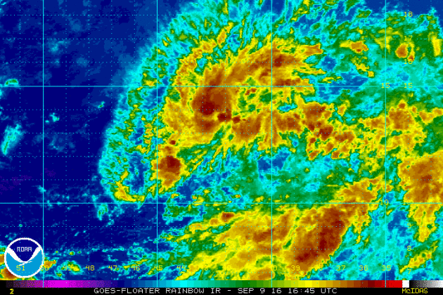
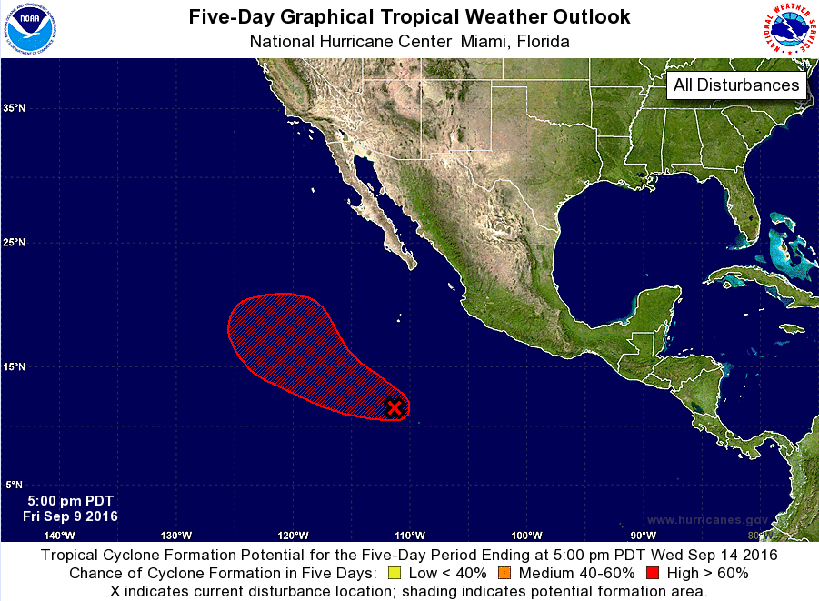
Tropical Outlook
This particular blob of showers and storms below doesn't look like much, but currently holds a HIGH probability of tropical formation within the 5 day. This is located in the central Atlantic and is tracking toward the Northwest.
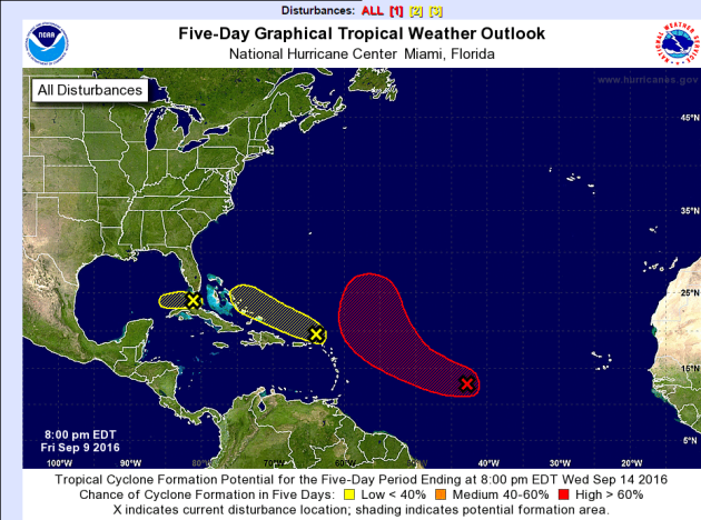
Atlantic Outlook
According to NOAA's NHC, there are 3 separate areas of interest, one in particular (in red below) has a HIGH probability of tropical formation within the next 5 days. The other 2 are closer to the U.S., but have a low probability of tropical formation during that time.
Eastern Pacific Update
The National Hurricane Center is also watching a wave of energy in the Eastern Pacific that currently has a HIGH probability of tropical formation. This has developed on the heels of NEWTON that eventually moved into Arizona and New Mexico with gusty winds and heavy rain.
__________________________________________
"Providing prod & svcs that describe & predict changes in the environment"
"As the primary research and development organization within NOAA, NOAA Research explores the Earth and atmosphere from the surface of the sun to the depths of the ocean. We conduct research in three major areas: weather and air quality, climate, and ocean and coastal resources. Our role within NOAA is to provide products and services that describe and predict changes in the environment. Research results allow decision makers to make effective judgments in order to prevent the loss of human life and conserve and manage natural resources while maintaining a strong economy."
___________________________________________________
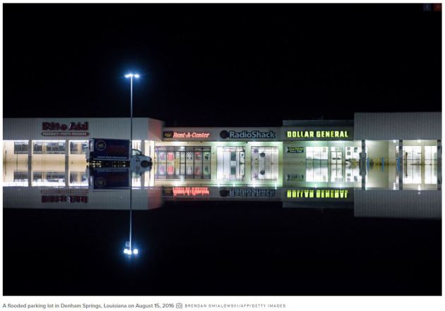
Climate Change and the Terrible, No-Good Odds of Bad Weather
"ABOUT THREE WEEKS ago, a three-day storm came through southern Louisiana and flooded the state capitol. Baton Rouge itself had over 17 inches of rainfall in the 72-hour period. Some nearby parishes got more than two feet. The storm was historic, dumping three times as much rain as Hurricane Katrina. So, was it climate change? A new study from NOAA and the World Weather Attribution says yes, sorta. It’s complicated. Deep breath: With climate change, the odds of a storm withthis magnitude hitting this region during this time this year are one in 30. In an alternate world in which the Industrial Revolution had never happened, the odds would have been one in 50. An increase of 40 percent, all thanks to climate change. In terms of actual rainfall, the study says global warming added about 10 percent to what would have fallen anyway—a few inches. These results aren’t easy to explain. But these dense little statistics are important: Understanding them will help as engineers adapt infrastructure to the altered weather regimes civilization has baked into the atmosphere."
See more from WIRED.com HERE:
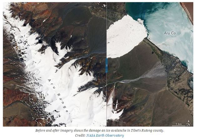
_______________________________________________________"Scientists Are Racing to Unravel an Ice Avalanche Mystery"
"In July, one of the largest ice avalanches ever recorded ripped through a remote area of Tibet. Scientists are now working in the region to understand what caused such a massive chunk of ice to break off a glacier and wreak havoc on the landscape and people living in the region. There are signs climate change could have played a role in weakening the glacier and could make others in the region and around the world more unstable with potentially deadly results for people living in their shadow. On July 17, a huge swath of ice tore across the landscape in Rutog county in the northwest corner of Tibet, rumbling for 3.7 miles before reaching the shores of Aru Co Lake. The ice slide killed nine herders in its path along with 350 sheep and 110 yak, according to news reports. Local authorities also evacuated other people living in the area after discovering cracks in surrounding glaciers."
See more from ClimateCentral.org HERE:
Thanks for checking in and have a great weekend ahead!
Don't forget to follow me on Twitter @TNelsonWX
Don't forget to follow me on Twitter @TNelsonWX

No comments:
Post a Comment