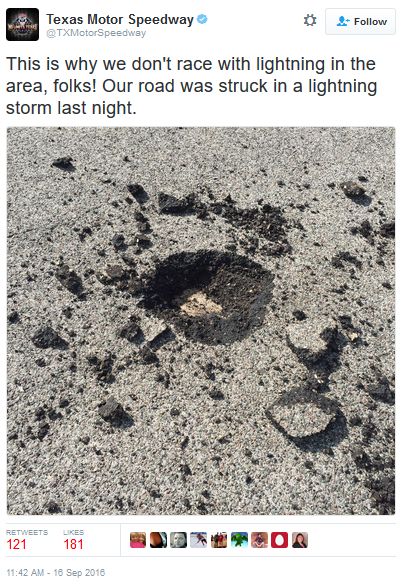
Lightning Strikes Texas Motor Speedway
Texas
Motor Speedway had a thunderstorm move through the area Thursday.
Apparently lightning struck the track, leaving this hole in the middle.
This is one of the many reasons why you should shelter inside when a
thunderstorm is approaching/in the area! See the full tweet (and comments) by clicking here.
_______________________________________________
_______________________________________________
Highs Near 80 Today - Fall Begins This Week
By D.J. Kayser, filling in for Paul DouglasWe are nearing the end.
The end of summer, that is. Astronomical fall officially beings this Thursday at 9:21 AM, meaning you only have a few more days to enjoy what is left of summer. On Thursday, the sun will be directly overhead the equator, creating nearly equal amounts of day and night.
Unfortunately, that means we have to be losing daylight to to be able to get close to equal day and night. Right now we are losing a little more than three minutes of daylight a day here in the Twin Cities, and on the 25th of this month we will start our long stretch of days with less than 12 hours of sunlight. We won't see more than 12 hours of sunlight again until March 17, 2017, right around the beginning of spring.
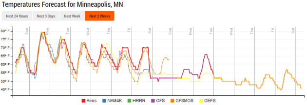
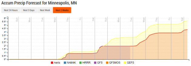
The good news is that it'll continue to feel like summer today across the region, with highs soaring to near 80 under sunny skies. Nice weather will continue into the beginning of the week, but fall looks to start on a rainy note across the region, with 2-4" of rain possible from Wednesday into next weekend.
By D.J. Kayser, filling in for Paul DouglasWe are nearing the end.
The end of summer, that is. Astronomical fall officially beings this Thursday at 9:21 AM, meaning you only have a few more days to enjoy what is left of summer. On Thursday, the sun will be directly overhead the equator, creating nearly equal amounts of day and night.
Unfortunately, that means we have to be losing daylight to to be able to get close to equal day and night. Right now we are losing a little more than three minutes of daylight a day here in the Twin Cities, and on the 25th of this month we will start our long stretch of days with less than 12 hours of sunlight. We won't see more than 12 hours of sunlight again until March 17, 2017, right around the beginning of spring.
The good news is that it'll continue to feel like summer today across the region, with highs soaring to near 80 under sunny skies. Nice weather will continue into the beginning of the week, but fall looks to start on a rainy note across the region, with 2-4" of rain possible from Wednesday into next weekend.
_______________________________________________

Extended Forecast for Minneapolis
SUNDAY: Mainly sunny. High 79. Low 61. Chance of precipitation 10%. Winds S 5-10 mph.
MONDAY: Mainly sunny, a touch cooler. High 77. Low 54. Chance of precipitation 10%. Winds W 5-10 mph.
TUESDAY: Blue skies. Storm chance overnight. High 75. Low 58. Chance of precipitation 20%. Winds SE 3-5 mph.
WEDNESDAY: Storms with heavy rain. High 72. Low 58. Chance of precipitation 50%. Winds SE 5-10 mph.
THURSDAY: More rain, especially early. High 72. Low 57. Chance of precipitation 40%. Winds E 3-5 mph.
FRIDAY: Another round of rain. High 72. Low 58. Chance of precipitation 30%. Winds SE 5-10 mph.
SATURDAY: Lingering showers possible. High 71. Low 57. Chance of precipitation 30%. Winds SE 5-10 mph.
_______________________________________________
This Day in Weather History
September 18th
1997:
An F3 tornado destroys several buildings and damages numerous others.
Hundreds of trees are knocked down. A number of cattle are also killed
in a collapsed barn. One man is injured when the tornado engulfs his car
and throws it into a nearby woods. A second man is critically injured
when his garage collapses, then dies several weeks later. The total path
length of the tornado from 1 NE of Lastrup to Onamia is 17 miles. Total
property damage is estimated at $1.7 million. In total, 6 tornadoes
touch down in Morrison, Mille Lacs, and Kanabec.September 18th
1991: Duluth gets 2.5 inches of snow five days before the beginning of Fall.
1971: A brush fire at Lake Alexander in Morrison County spawns a 10-foot wide, 50-foot high 'fire whirl.' It moved out over the lake, overturned a 1,800 pound pontoon boat, and then dissipated as it moved back to shore.
1903: 3.75 inches of rain falls in the Minneapolis area.
_______________________________________________
Average Temperatures & Precipitation for Minneapolis
September 18th
September 18th
Average High: 71F (Record: 93F set in 1891)
Average Low: 51F (Record: 32F set in 1939)
Average Precipitation: 0.10" (Record: 3.75" set in 1905)
________________________________________________
Average Low: 51F (Record: 32F set in 1939)
Average Precipitation: 0.10" (Record: 3.75" set in 1905)
________________________________________________
Sunrise/Sunset Times for Minneapolis
September 18th
Sunrise: 6:56 AMSeptember 18th
Sunset: 7:17 PM
*Length Of Day: 12 hours, 21 minutes and 9 seconds
*Daylight Lost Since Yesterday: ~3 minutes and 6 secondss
*Next Sunrise That Is At/After 7 AM: September 21st (7:00 am)
*Next Sunset That Is Before 7 PM: September 28th (6:58 pm)
________________________________________________
Minnesota Weather Outlook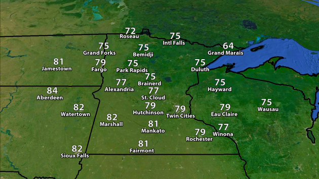
We'll see highs Sunday a good 5-10 degrees warmer vs. Saturday across most of Minnesota, with highs approaching 80 here in the Twin Cities. Highs will be in the 80s across parts of southern Minnesota. Otherwise, 70s will be quite common across the state - the only place they won't be is along parts of the north shore of Lake Superior up toward Grand Marais, which will be stuck in the 60s.
________________________________________________
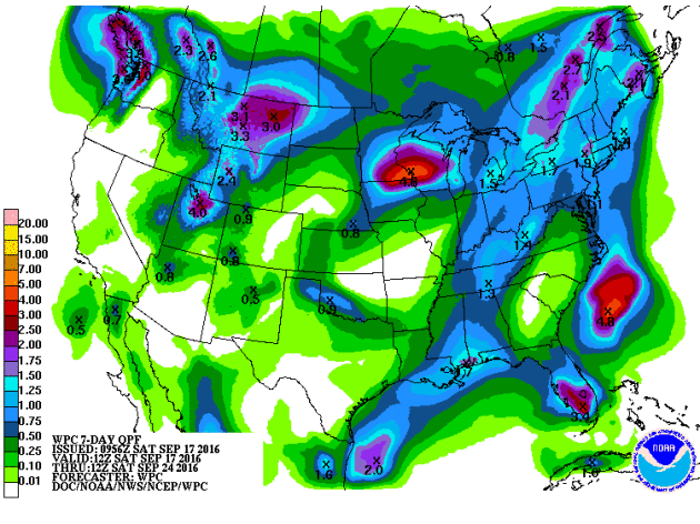
National Weather Stories
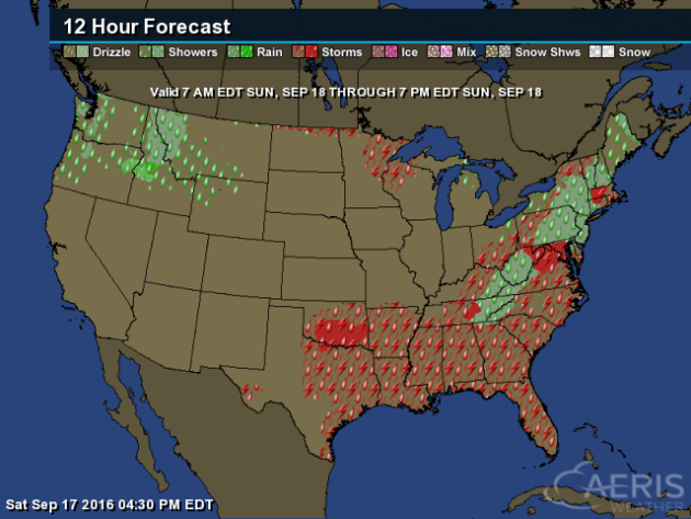
On
Sunday, areas along the East coast and across parts of the South could
see showers and thunderstorms along a cold front. Elsewhere, a few
storms may pop in the upper Midwest associated with a warm front, and
showers will be possible in the Northwest.
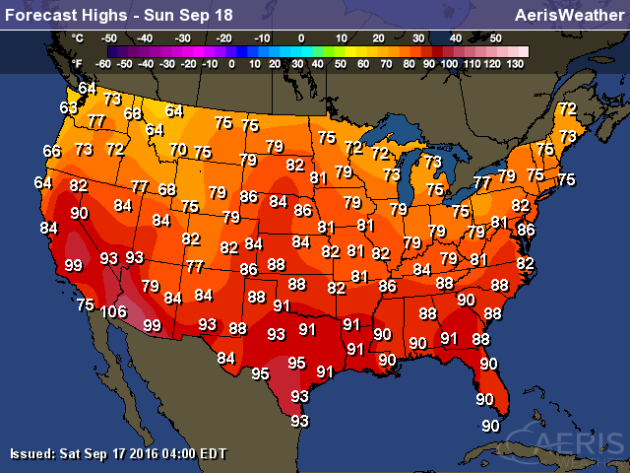
Highs
on Sunday will range from the 60s in parts of Northwest (70s across the
rest of the northern tier of states) to the 90s across parts of
California and the Desert Southwest as well as portions of the South and
Southeast. We will easily see a few locations in the Desert Southwest
topping 100 on Sunday, with a forecast of 106 in Yuma.
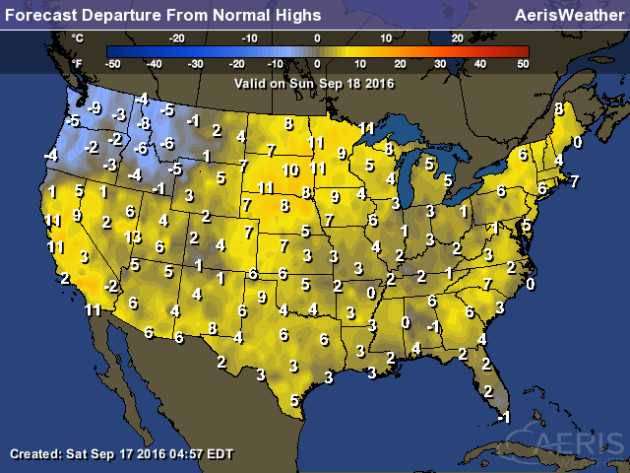
The
cool spot of the nation Sunday will be in the Northwest, where highs
will be between 5-10 degrees below average. The rest of the nation looks
to be mainly at or above average.
Drought In Massachusetts
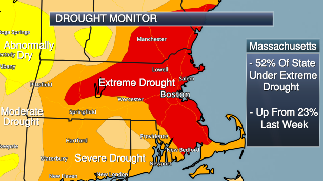
Extreme
drought - the second highest category - expanded to cover over half the
state of Massachusetts this week. Eric Fisher takes a look at what it
would take to end the drought over at CBS Boston: "In
an odd and frustrating twist, it has rained 9 out of the first 15 days
in September over they city of Boston. But it’s been a sprinkle here and
a couple hundredths there. Maddening. Now mired in one of the worst
droughts in southern New England history, it’s going to take much more
than scattered showers or even a tropical system to get us out of the
hole."
iPhone 7 Has A Barometric Vent

Apparently
Apple has put a barometric vent in the new iPhones in the space where
the headphone jack used to be. What does that mean? More from The Verge: "Apparently
adding all the waterproofing to the iPhone 7 and 7 Plus meant that it
was more of a sealed box, and so to be able to have an accurate and
working barometer, Apple used that space. The barometer is the thing
that allows a phone to measure altitude, and Apple points out that on
the iPhone 7 it can measure even minor changes like climbing a flight of
stairs."
________________________________________________
Thanks for checking in and have a great Sunday! Don't forget you can follow me on Twitter (@dkayserwx) or on Facebook (Meteorologist D.J. Kayser)!
- D.J. Kayser

No comments:
Post a Comment