Changing Colors
The
leaves are slowly starting to change color across the state, helped
along by the cool night or two that we had earlier this week. Already
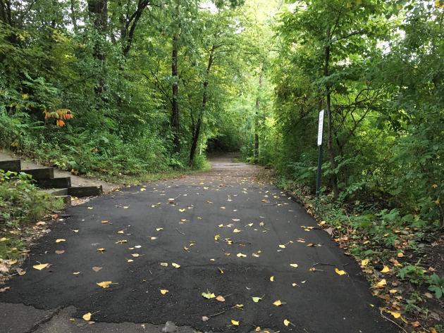
some yellow and red colored leaves are starting to dot some of the
trails here in the Twin Cities, but as you can see from this picture
Friday morning many are still green.
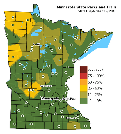
The
Minnesota DNR is updating their Fall Color Finder just about daily as
state parks continue to report in with the latest. Already some parks in
parts of northwest and central Minnesota are reporting between 25-50%
color, with a number of parks across northern Minnesota reporting at
least 10-25% color. Make sure you check to find out how the color in
your local state park is before you head out: http://www.dnr.state.mn.us/fall_colors/index.html

Typical
fall color peak isn't until late September to mid-October here across
the Twin Cities, with peak of course being earlier across northern
portions of the state.
_______________________________________________
_______________________________________________
Spectacular Weekend Ahead - Fall Colors Starting To Pop
By D.J. Kayser, filling in for Paul Douglas
By D.J. Kayser, filling in for Paul Douglas
Have
you noticed a change in your neighborhood in recent days? Fall colors
are slowly starting to pop in the trees. It has even started to feel a
bit more like fall in the temperature department, especially after a low
of 47 Wednesday morning.
The Minnesota DNR
reports that several state parks are reporting between 25-50% color
across mainly northwest and central Minnesota. These numbers are
expected to grow quickly with the average peak across northern Minnesota
typically between mid-September to early October. Here in the Twin
Cities, we have to normally wait until late September to mid-October for
our peak colors.
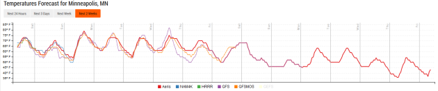
After rounds of rain the past
few days, the weather is clearing out in time for a spectacular weekend
to get outside and view some of the changing colors. Sunnier skies can
be expected this weekend behind the cold front with warming temperatures
- low 70s today, upper 70s tomorrow. While an isolated storm is
possible Sunday Night into Monday, our next best shot at rain doesn't
appear until the middle of next week.
_______________________________________________
Extended Forecast for Minneapolis
SATURDAY: Gradually clearing skies. High 70. Low 54. Chance of precipitation 0%. Winds W 5-10 mph.
SUNDAY: Mainly sunny. Isolated storm late? High 79. Low 61. Chance of precipitation 20%. Winds S 5-10 mph.
MONDAY: Sunny and warm. High 76. Low 55. Chance of precipitation 10%. Winds SW 3-5 mph.
TUESDAY: Blue skies. Late night storm possible. High 74. Low 58. Chance of precipitation 20%. Winds SW 3-5 mph.
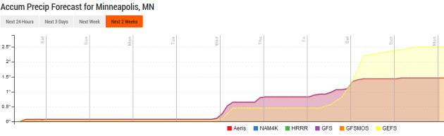
WEDNESDAY: Storm chances on the increase. High 76. Low 59. Chance of precipitation 30%. Winds SE 5-10 mph.
SUNDAY: Mainly sunny. Isolated storm late? High 79. Low 61. Chance of precipitation 20%. Winds S 5-10 mph.
MONDAY: Sunny and warm. High 76. Low 55. Chance of precipitation 10%. Winds SW 3-5 mph.
TUESDAY: Blue skies. Late night storm possible. High 74. Low 58. Chance of precipitation 20%. Winds SW 3-5 mph.
WEDNESDAY: Storm chances on the increase. High 76. Low 59. Chance of precipitation 30%. Winds SE 5-10 mph.
THURSDAY: Heavy rain possible. High 72. Low 51. Chance of precipitation 40%. Winds S 5-10 mph.
FRIDAY: Storm chances linger. High 68. Low 50. Chance of precipitation 30%. Winds E 10-15 mph.
_______________________________________________
This Day in Weather History
September 17th
1955: A late-season tornado hits Koochiching County. Most damage is confined to trees.September 17th
1911: Pipestone is hit with baseball-sized hail that smashes numerous windows at the Calumet Hotel and high school. The local observer measures hail three inches deep. People get their photos taken in automobiles surrounded by the icy white ground.
_______________________________________________
Average Temperatures & Precipitation for Minneapolis
September 17th
September 17th
Average High: 71F (Record: 96F set in 1895)
Average Low: 52F (Record: 34F set in 1943)
Average Precipitation: 0.10" (Record: 2.37" set in 2015)
________________________________________________
Average Low: 52F (Record: 34F set in 1943)
Average Precipitation: 0.10" (Record: 2.37" set in 2015)
________________________________________________
Sunrise/Sunset Times for Minneapolis
September 17th
Sunrise: 6:55 AMSeptember 17th
Sunset: 7:19 PM
*Length Of Day: 12 hours, 24 minutes and 15 seconds
*Daylight Lost Since Yesterday: ~3mins & 5secs
*Next Sunrise That Is At/After 7 AM: September 21st (7:00 am)
*Next Sunset That Is Before 7 PM: September 28th (6:58 pm)
________________________________________________
Minnesota Weather Outlook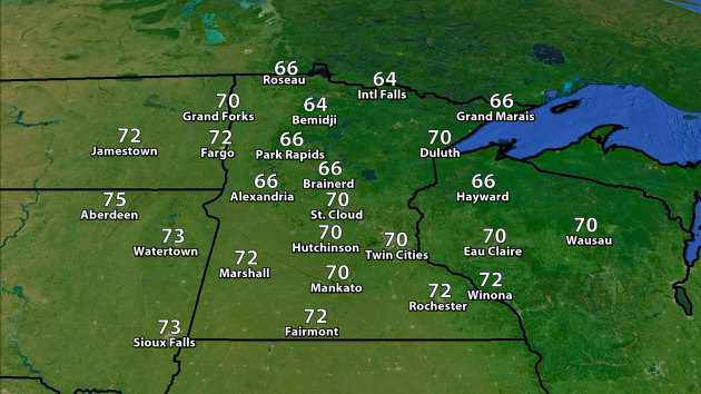
Expected Highs Saturday.
We'll see clearing skies throughout the day Saturday with temperatures warming into the 60s across northern Minnesota and the low 70s across southern Minnesota. A few showers will still be possible across parts of north central and northeast Minnesota, but those will slowly fade throughout the day.
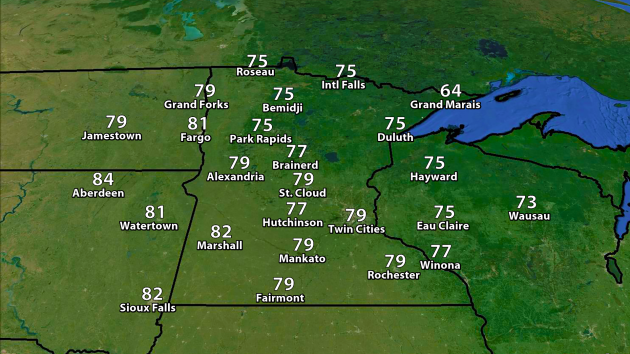
Expected Highs Sunday.
Sunday will be a good 5-10 degrees warmer across most of the state, as highs climb into the mid to upper 70s. Some 80s are possible across southern Minnesota, meanwhile Grand Marais will be stuck in the mid 60s.
________________________________________________
National Weather Stories
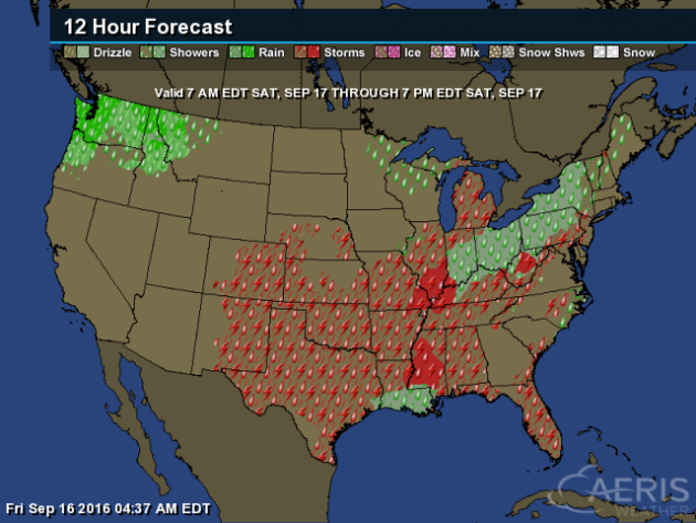
On
Saturday, storms will be possible from the Deep South through the lower
and mid-Mississippi Valleys onward into the Northeast along a cold
front. Some rain will also be possible in parts of the Northwest.
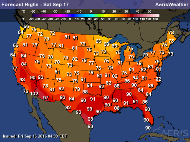
Highs
on Saturday will range from the 60s in parts of the Great Lakes region
and the Pacific Northwest to 90s across the Desert Southwest and parts
of the South. A few locations in the Desert Southwest could top 100.
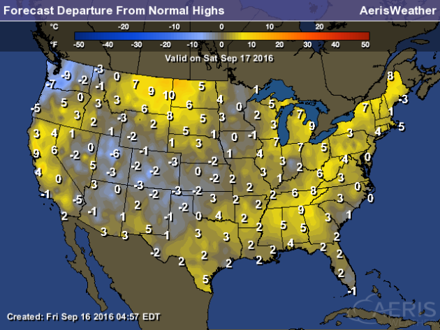
Highs
across a good portion of the nation will be around average to above
average Saturday. The only real pockets of cool air will be in parts of
the Northwest as well as the Rockies and the central/southern High
Plains.
Drought In Massachusetts
Drought In Massachusetts
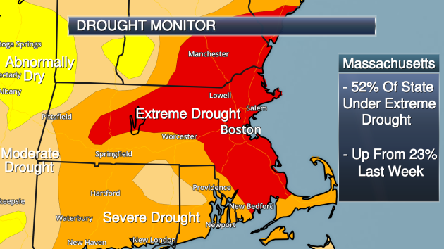
Extreme
drought - the second highest category - expanded to cover over half the
state of Massachusetts this week. Eric Fisher takes a look at what it
would take to end the drought over at CBS Boston: "In
an odd and frustrating twist, it has rained 9 out of the first 15 days
in September over they city of Boston. But it’s been a sprinkle here and
a couple hundredths there. Maddening. Now mired in one of the worst
droughts in southern New England history, it’s going to take much more
than scattered showers or even a tropical system to get us out of the
hole."
________________________________________________
Thanks for checking in and have a great Saturday! Don't forget you can follow me on Twitter (@dkayserwx) or on Facebook (Meteorologist D.J. Kayser)!
- D.J. Kayser

No comments:
Post a Comment