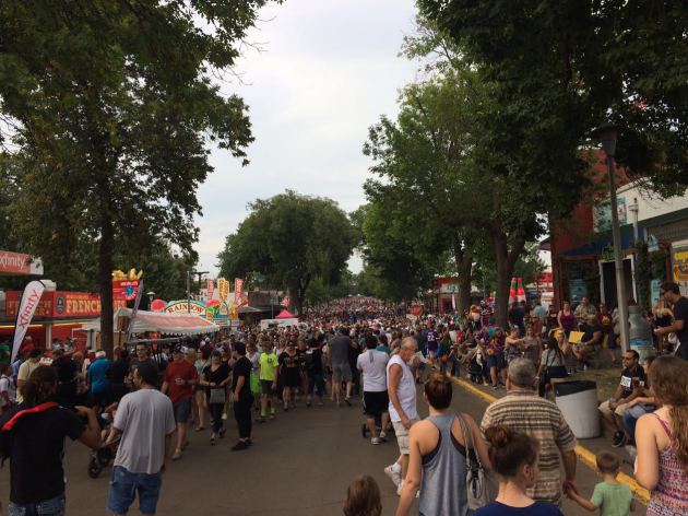
Sunday at the Fair
Crowds were reportedly 'not too bad' at the Fair on Sunday. That coupled with clouds, a decent breeze and a few sprinkles in the afternoon made for comfortable day to roam around.
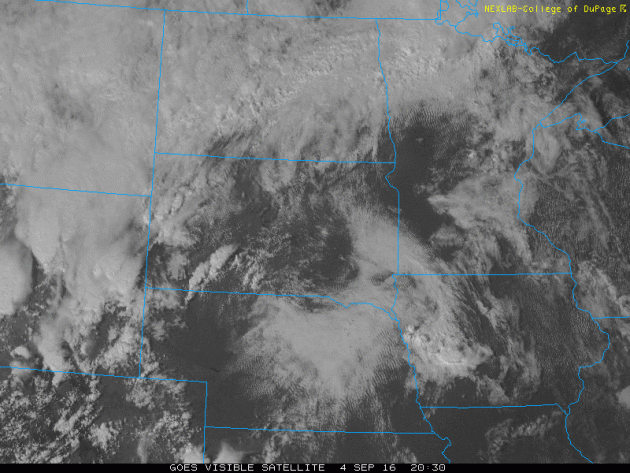
Visible Satellite PM Sunday
Here's an impressive visible satellite image from just before sunset Sunday evening. Note the thunderstorms ballooning over the Dakotas and Nebraska. These thunderstorms were expected to bring heavy rain to parts of Minnesota and Wisconsin through early Monday morning.
_______________________________________________
"Climate Summary for August 2016"
No question, July and August were very wet months across the Midwest. Some spots across the state saw nearly a foot of water just during the month of August! Thanks to Mark Seeley from the MN Climate Office for this August Climate Summary below.
"Average temperatures for August from observers around the state were generally warmer than normal by 1 to 2 degrees F. The hottest periods during the month were over the first ten days, when daily Heat Index values soared above 100°F in several locations. Marshall (Lyon County) reported the highest temperature for the state on the 10th with a reading of 96°F. The lowest temperature for the month was just 37°F at International Falls on the 21st. For the first 8 months of 2016 temperatures have consistently been warmer than normal in Minnesota, placing this period as the 6th warmest in state history. The monthly total rainfall was above normal for most places in the state, except for a few isolated pockets of dryness. Many climate observers reported total monthly rainfall that was 2-3 times normal, and on a statewide basis it was the 3rd wettest August in history and wettest since 1980. For many communities it was a near-record or record wet August. Some examples include:"
11.85 inches at Red Wing
11.82 inches at Theilman (2nd wettest)
11.70 inches at Waseca (2nd wettest)
11.37 inches at Redwood Falls
9.70 inches at Chanhassen
8.96 inches at Twin Valley
8.74 inches at downtown St Paul
9.90 inches at University of Minnesota St Paul Campus
7.86 inches at Kabetogama
9.66 inches at Faribault (4th wettest)
10.21 inches at Milan (2nd wettest)
10.23 inches at Wabasha (2nd wettest)
8.36 inches at St Cloud (2nd wettest)
7.82 inches at MSP (6th wettest)
"Severe weather plagued the state during the month on several occasions: Over August 10-11 severe thunderstorms moved across the west-central part of the state, bringing 4-7 inch rains to the Willmar-Olivia area, and later in the day to Wabasha County. Then over August 23-24 heavy rains fell across portions of southeastern Minnesota delivering 2-3 inch amounts, and nearly 8.5 inches south of the border in Decorah, Iowa. Then over August 27-28 heavy rains, strong winds, and some tornadoes were reported in Polk and Norman Counties of northwestern Minnesota. Some farm buildings were damaged in Norman County. With the added rainfall from August, following a wet July, this summer season (June-August) now ranks as the 4th wettest in state history, as the average 3-month rainfall for the state was just shy of 16 inches. For the Twin Cities this has been the 8th wettest summer in history with a total rainfall of 17.40 inches."
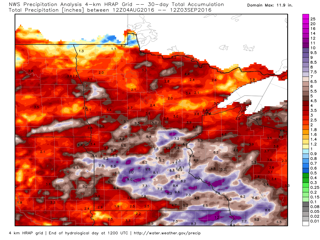
Rainfall Past 30 Days
Here's the radar estimated rainfall over the past 30 days, which suggests some fairly significant tallies across the southern half of the state and into western Wisconsin. Some spots saw nearly 12" of rain!
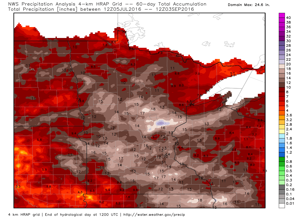
Rainfall Past 60 Days
The radar estimated rainfall over the past 60 days suggests several locations across the central and southern part of the state with some 12" to near 18" amounts.
______________________________
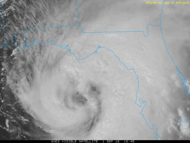
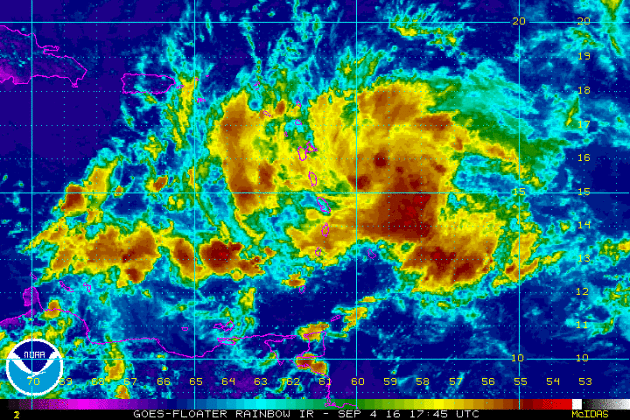
HERMINE at Landfall Late Thursday Night
Here's a look at Hurricane Hermine just before landfall along the Florida coastline PM Thursday. Outer bands began whipping the state early Thursday, some of which produced severe weather with tornadoes and locally heavy rain. Interestingly, HERMINE was the first hurricane to affect the state since Hurricane Wilma in 2005, 11 years ago.

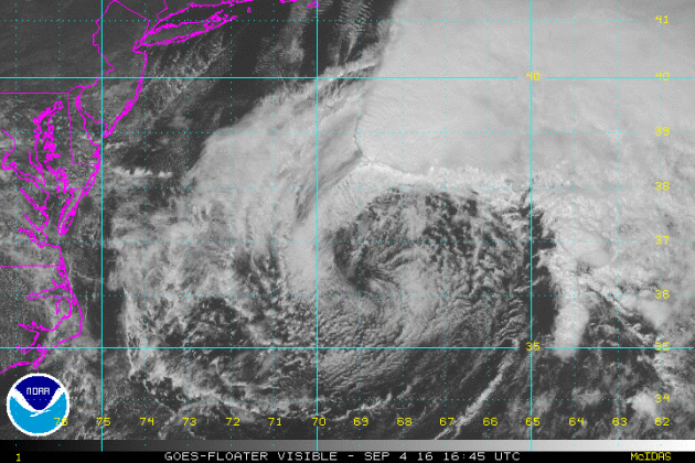
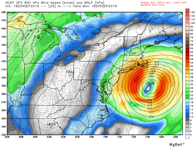
This was the view of Hermine late Sunday just off the Mid-Atlantic coast. Bands of heavy rain shifted into the open waters of the Atlantic, but gusty winds were still affecting parts of the Mid-Atlantic and Northeast Coat. As of PM Sunday, Hermine was a Post-Tropical Cyclone with sustained winds up to 70mph and is expected to remain at tropical storm strength was we continue through early this week. Note that there was still a very apparent center of circulation, but thunderstorms surrounding the center weren't quite as impressive as they were on Thursday evening just before landfall with the Florida Panhandle.
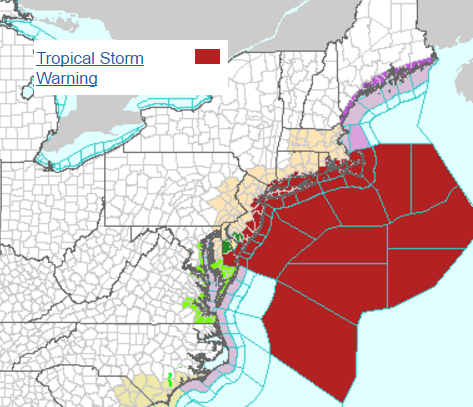
Topical Warnings Continue
Tropical Watches and Warnings have now been extended to parts of the Northeast, including New York City, in advance of Hermine as if lifts northeast along the coast.
...TROPICAL STORM WATCH REMAINS IN EFFECT...
* LOCATIONS AFFECTED - BATTERY PARK - HARLEM - CENTRAL PARK
* WIND - LATEST LOCAL FORECAST: BELOW TROPICAL STORM FORCE WIND - PEAK WIND FORECAST: 15-25 MPH WITH GUSTS TO 40 MPH
* STORM SURGE - LATEST LOCAL FORECAST: LOCALIZED STORM SURGE POSSIBLE - PEAK STORM SURGE INUNDATION: THE POTENTIAL FOR UP TO 2 FEET ABOVE GROUND SOMEWHERE WITHIN SURGE PRONE AREAS - WINDOW OF CONCERN: THROUGH WEDNESDAY MORNING
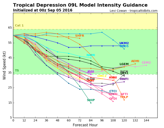
The forecast intensity for Hermine suggests that the overall intensity will remain at tropical storm strength over the next several days. While Hermine isn't forecast to become a Hurricane again, gusty winds and high surf along the coast will make for an interesting early week along the East Coast.
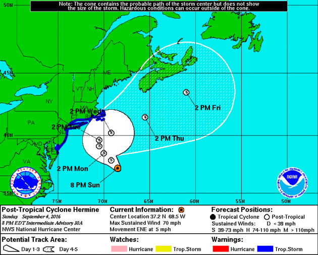
Tracking HERMINE
The forecast track from NOAA's NHC suggests that Hermine will SLOWLY track north/northwest over the next couple of days before turning back to the northeast. Folks along the coast will be susceptible to strong winds, heavier rain and coastal flooding.
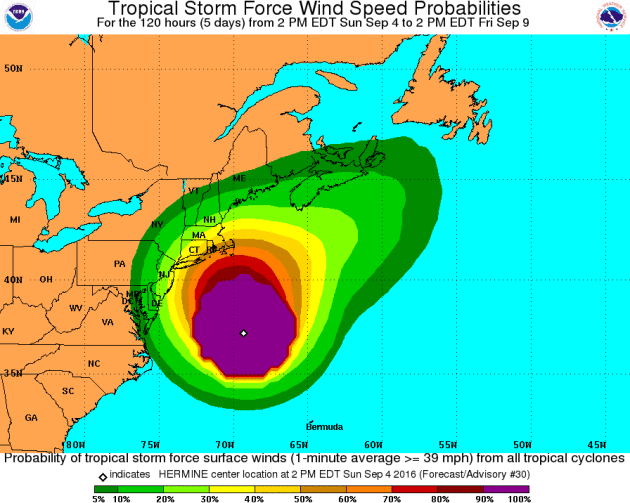
Tropical Storm Force Winds
Here's a look at the Tropical Storm Force Wind Speed Probability through midweek next week. Note that some folks along the coast see up to a 50%-60% chance, which could make the first full week of September interesting!
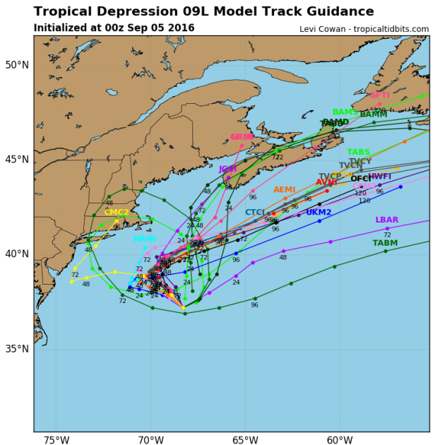
Spaghetti Plots
Now that Hermine has moved back over the open waters of the Atlantic, the Spaghetti plots seem to be a little more sure with it sitting nearly stationary for a couple/few days just off the Mid-Atlantic/Northeast coast before moving northeast late this week/next weekend. The good news is that inclement weather conditions will slowly east over the coming days for folks along the coast.
Tracking HERMINE
Here's a forecast view of Hermine midday Monday, which shows a nearly stationary storm just off the Eastern Seaboard. Prolonged gusty winds, high coastal surf and heavier rain chances will continue for folks along the coast through the upcoming week.
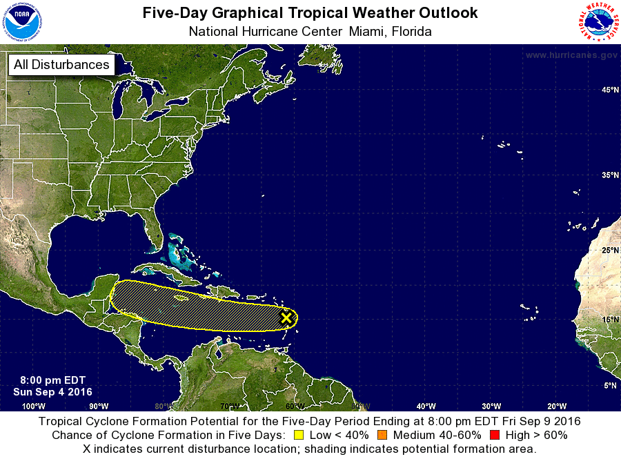
Keeping and Eye on the Atlantic
While it may not look like much yet, NOAA's NHC is keeping an eye on this particular wave of energy as it has a low chance of becoming a tropical cyclone over the next 5 days... Stay tuned!
Atlantic 5 Day Outlook
The National Hurricane Center will continue to watch the wave of energy in the Central Atlantic over the next few days. At this point, the forecast calls for less than a 40% chance of tropical formation within the next 5 days.
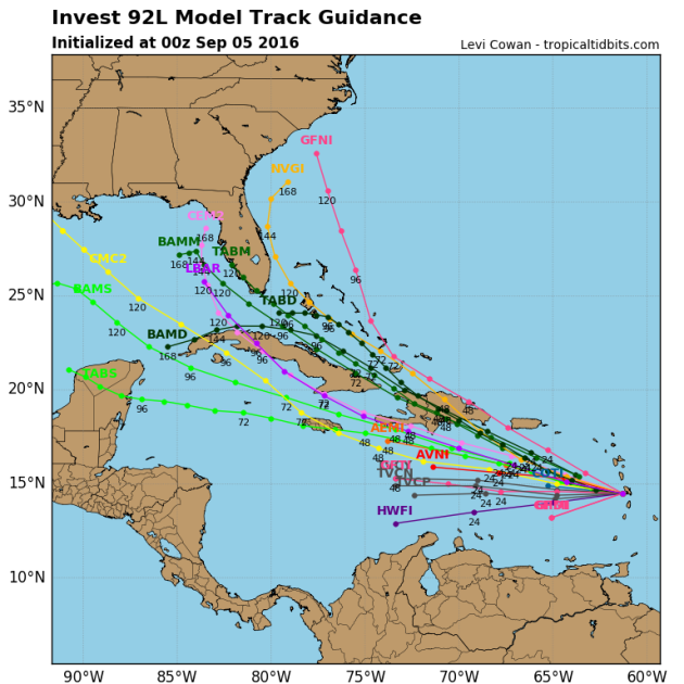
Tracking the Tropics
Spaghetti plots for this particular wave look a little interesting. The trajectory is something to keep an eye on as it heads northwest over the next several days.
___________________________________________________
Muggy Labor Day With Locally Heavy Rain This Week
Time seems to go faster and faster the older I get. Having 2 kids, sports, jobs, chores around the house... it never ends. Where the heck did summer go? I guess my late father was right when he said, "Enjoy it now son, blink and it's over."
Labor Day Monday marks the unofficial end of summer and the last day of the Great Minnesota Get Together. Regretfully, everything on-a-stick went straight to my hips this year, but we can't complain too much about the weather. Not too hot, or too cold with a near average amount of rainfall days; just about perfect honestly.
AM puddles today give way to a muggy and somewhat unsettled afternoon. Despite a few pop-up thundershowers, most of the day looks dry until later this evening as a line potentially stronger storms rumbles our way.
Hermine, stalled off the East Coast, has created a meteorological log jam across the nation. The threat for thundery downpours continues for us much of the week with some locations seeing up to 1 to 3 inches of rain through Friday. Happy 'Soak-tember'.
____________________________________________________
Extended Weather Outlook
SUNDAY NIGHT: Mostly cloudy with scattered storms. Winds: SSE 10-15. Low: 66.
LABOR DAY: Warmer and muggier. AM puddles with storms developing late, some could be strong. Winds: S 10-15. High: 85
MONDAY NIGHT: Showers and storm likely with locally heavy rainfall. Winds: S 10. Low: 69.
TUESDAY: Mostly cloudy. Scattered storms with locally heavy rainfall. Winds: NNE 5-10. High: 78
WEDNESDAY: Mostly cloudy. Numerous thundershowers. Winds: ENE 5-10. Wake-up: 65. High: 78
THURSDAY: AM puddles, slow PM clearing. Winds: WNW 5-10. Wake-up: 63. High: 76.
FRIDAY: Sunny start, a few rumbles late. Winds: SSE 5-10. Wake-up: 60. High: 76.
SATURDAY: Lingering AM shower, breezy and cooler. Winds: W 5-15. Wake-up: 57. High: 72.
SUNDAY: Bright sun. Refreshing. Winds: SSW 5-10. Wake-up: 55. High: 75.
_______________________________
_______________________________
This Day in Weather History
September 5th
September 5th
1990: Nine inches of rain falls in Duluth by the end of the following day, washing out $1,000,000 worth of roads.
1982: 77 mph winds are reported in Anoka County.
________________________________
________________________________
Average High/Low for Minneapolis
September 5th
September 5th
Average High: 76F (Record: 98F set in 1922)
Average Low: 57F (Record: 36F set in 1962)
_________________________________
Average Low: 57F (Record: 36F set in 1962)
_________________________________
Sunrise/Sunset Times for Minneapolis
September 5th
September 5th
Sunrise: 6:41am
Sunset: 7:42pm
Sunset: 7:42pm
*Daylight Lost Since Yesterday: ~3mins & 2sec
*Daylight Lost Since Summer Solstice: ~2hours and 33mins
__________________________________
*Daylight Lost Since Summer Solstice: ~2hours and 33mins
__________________________________
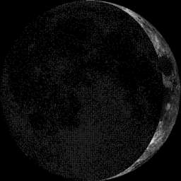
Moon Phase for September 5th at Midnight
3.2 Days Before First Quarter
3.2 Days Before First Quarter
___________________________________
Weather Outlook Monday
Labor Day Monday will be the warmest of muggiest of the long holiday weekend with some locations across the southern half of the state warming into the mid 80s with dewpoints approaching 70F. This mid-summer heat and humidity won't last very long though as readings are expected to get back to near normal levels by the middle part of the week.
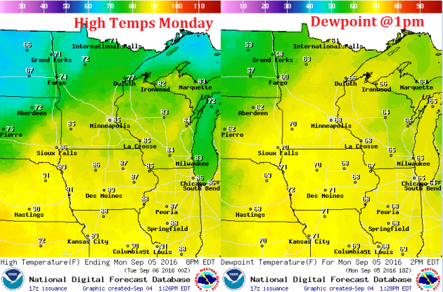
Weather Outlook Monday
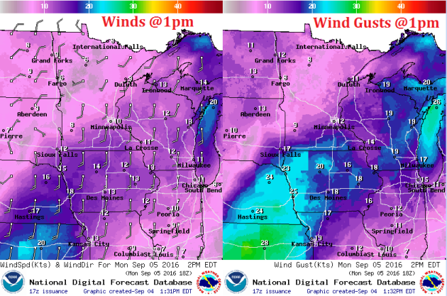
Winds will remain a bit breezy across the extreme southern part of the state on Monday with some gusts approaching 20mph. Winds across the northern half of the state will remain quite a bit calmer.
Weather Outlook Monday
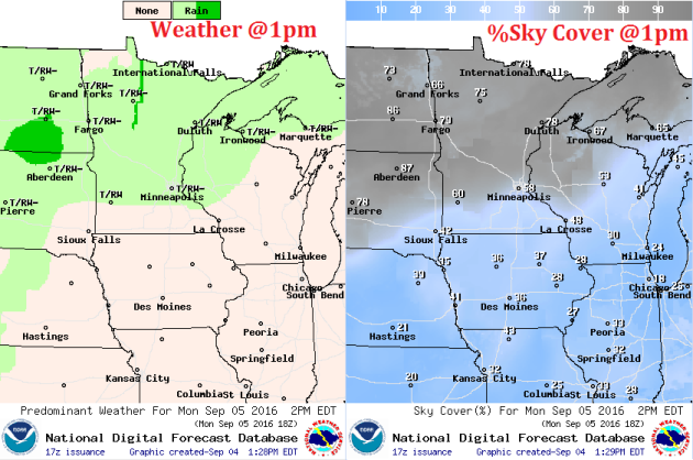
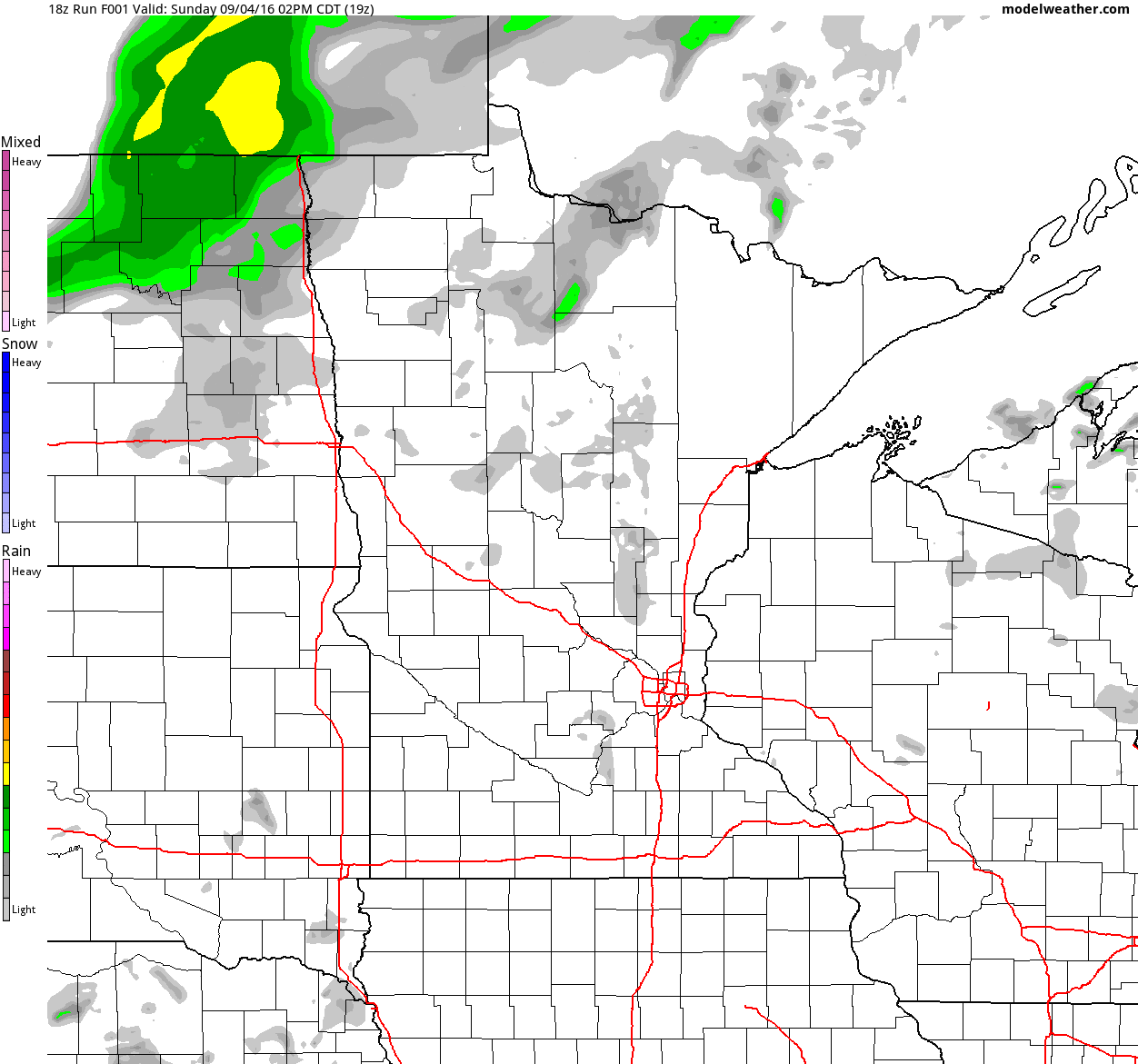
After a round of heavier thunderstorms overnight Sunday/early Monday morning, weather conditions look to improve a bit for Monday. Lingering clouds and spotty storms will be possible across the central and northern part of the state during the day, but the next round of heavier rain and thunder will move in late Monday.
Simulated Radar
The simulated radar from PM Sunday to PM Tuesday suggests that weather conditions will sour as we head into the week ahead. Waves of showers and storms look to push through the region, some of which could be strong to severe with locally heavy rainfall.
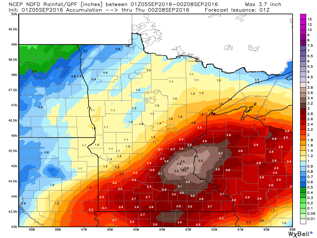
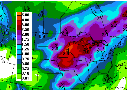
Rainfall Potential
Here's the rainfall potential through PM Wednesday, which suggests a fairly decent surge of moisture, which could lead to areas of flooding. Note that some areas could see up to 2" to 3"+, even around the Twin Cities metro!
__________________________________________
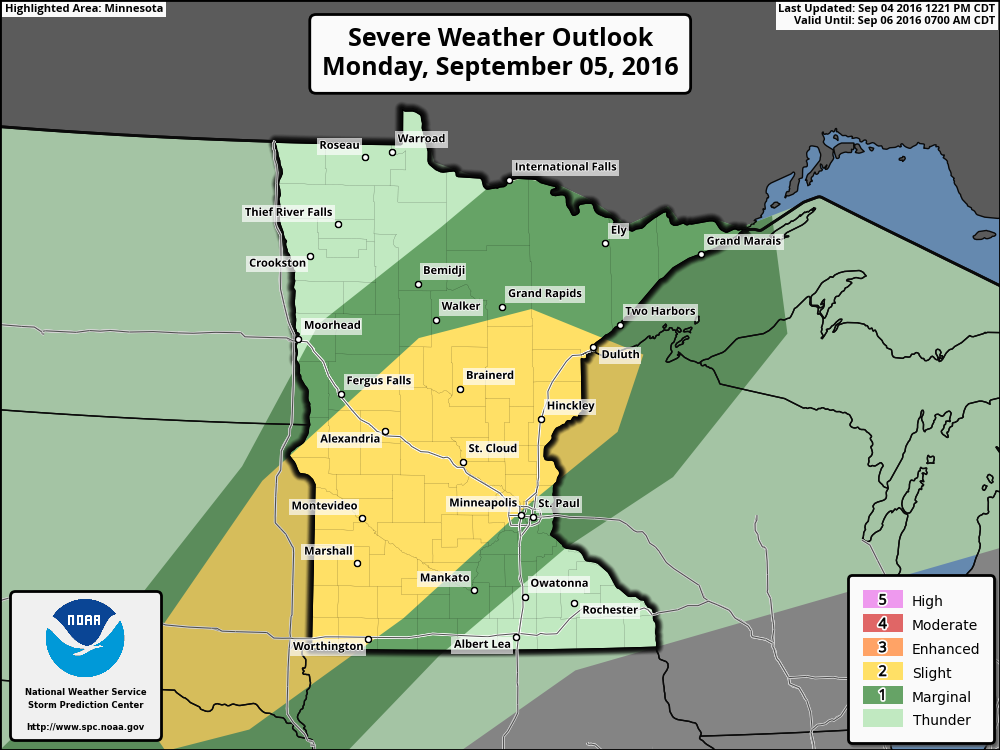
Severe Threat Monday
As the unsettle weather nears, strong to severe storms may develop late Monday...
...MID MISSOURI INTO UPPER MISSISSIPPI VALLEYS... DESPITE THE MAGNITUDE OF THE DEVELOPING POTENTIAL INSTABILITY...IT IS POSSIBLE THAT...IN THE WAKE OF EARLY DAY CONVECTION...PRIMARY RENEWED CONVECTIVE DEVELOPMENT MAY NOT OCCUR UNTIL MONDAY NIGHT...MOSTLY TO THE COOL SIDE OF THE SURFACE FRONTAL ZONE. CAPPING TO THE WARM SIDE OF THE FRONT MAY REMAIN SUPPRESSIVE...GIVEN AFOREMENTIONED UNCERTAIN MID/UPPER SUPPORT FOR CONVECTIVE DEVELOPMENT. IN THIS SCENARIO...MARGINALLY SEVERE HAIL AND...PERHAPS...LOCALLY HEAVY RAIN MAY BE THE PRIMARY CONVECTIVE HAZARDS. HOWEVER...THERE MAY BE AT LEAST A WINDOW OF OPPORTUNITY FOR BOUNDARY-LAYER BASED STORM DEVELOPMENT ALONG OR JUST AHEAD/SOUTHEAST OF THE FRONTAL ZONE. THIS COULD BECOME MOST PRONOUNCED ALONG A POSSIBLE WEAK FRONTAL WAVE THAT MAY DEVELOP NEAR THE FRONTAL INTERSECTION WITH OUTFLOW FROM EARLY DAY CONVECTION...PROBABLY ACROSS PARTS OF SOUTHWEST THROUGH CENTRAL MINNESOTA LATE MONDAY AFTERNOON AND EVENING. NEAR THIS FEATURE...IN THE PRESENCE OF BOUNDARY LAYER DEW POINTS AROUND 70F...MODESTLY STRONG WIND FIELDS VEERING WITH HEIGHT FROM LOWER THROUGH MID-LEVELS...MAY CONTRIBUTE TO FAVORABLE HODOGRAPHS FOR SUPERCELLS WITH A RISK FOR TORNADOES...IN ADDITION TO SEVERE HAIL.
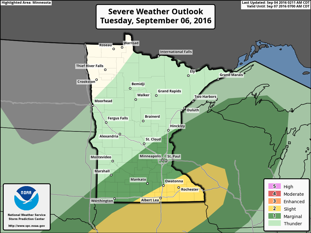
Severe Threat Tuesday
The severe threat on Sunday appears to shift a little farther south on Tuesday. Here's the latest from NOAA's SPC:
...EASTERN NEB TO WI... GUIDANCE VARIES REGARDING THE AMOUNT AND LOCATION OF ANY ONGOING CONVECTION TUESDAY MORNING...AND THIS COULD IMPACT RISK AREAS AS THESE DETAILS BECOME MORE CERTAIN. HOWEVER...GUIDANCE HAS BEEN REASONABLY CONSISTENT IN DEPICTING FAVORABLE CONDITIONS FOR CONTINUED SEVERE THREAT ALONG THE AFOREMENTIONED SURFACE BOUNDARY TUESDAY AFTERNOON/EVENING FROM THE MID-MO TO UPPER-MS VALLEY. SURFACE DEWPOINTS IN THE MID TO UPPER 60S WILL BE MAINTAINED ON SOUTHERLY LOW LEVEL FLOW AND A MODERATELY UNSTABLE AND UNCAPPED ENVIRONMENT IS DEPICTED IN FORECAST SOUNDINGS ACROSS THE REGION BY LATE AFTERNOON. STRONGEST DEEP LAYER SHEAR MAY REMAIN A BIT NORTH OF BEST THERMODYNAMIC ENVIRONMENT...BUT WILL BE SUFFICIENT TO SUPPORT INITIAL SUPERCELL STORM MODES...WITH ALL SEVERE HAZARDS POSSIBLE. UPSCALE GROWTH IS POSSIBLE INTO THE EVENING/OVERNIGHT ONCE AGAIN WHEN STRONGER UPPER FORCING/HEIGHT FALLS ENSUE IN CONJUNCTION WITH BOUNDARY PARALLEL FLOW.
7 Day Rainfall Outlook
The sunny, dry, comfortable weather as of late certainly has been a treat. Enjoy it while you can because unsettled and wetter weather returns late weekend into next week. According to NOAA's WPC, the 7 day rainfall forecast suggests fairly widespread 2" to 4" with isolated higher amounts, even close to the metro!
Extended Weather Outlook
The extended temperature outlook through the first full week of September suggests a bit of a warm up by the end of the weekend and Monday with muggier dewpoints as well. However, it appears that it won't last too long as readings settle back to near normal levels by the middle and end of the week.
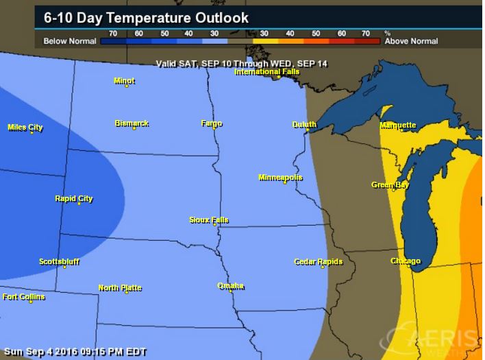
6 to 10 Day Temp Outlook
According to NOAA's CPC, the 6 to 10 day temperature outlook suggests a fairly decent chance of warmer than normal conditions settling in around the Great Lakes Region during the first full week of September. A bigger blob of cooler air will settle in across the Northwestern part of the country, which may drift our way as we approach the 2nd week of the month.
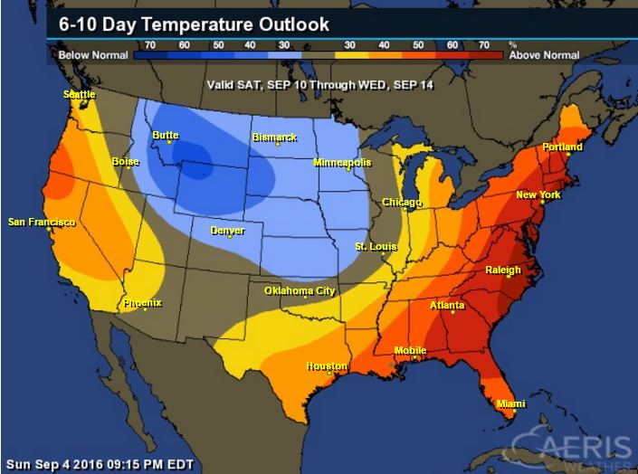
6 to 10 Day Temp Outlook
The national outlook suggests that much of the eastern part of the country will remain above average, however, there will be a fairly significant pocket of below average temps across the central and northern Rockies.
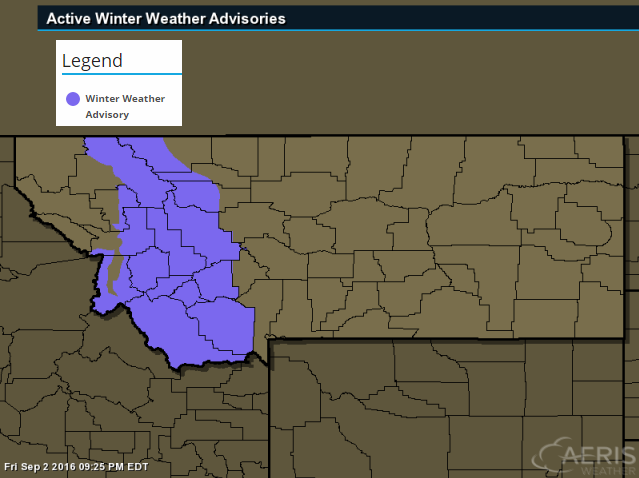
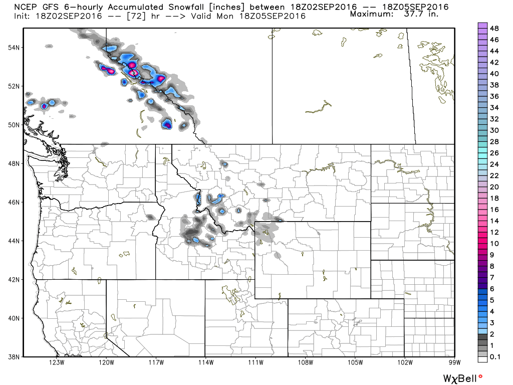
High Elevation Snow?
Take a look at this! The National Weather Service has issued a Winter Weather Advisory for parts of western Montana above 7000ft. for snowfall accumulations that could approach 2" to 5" from Sunday into Monday.
...WINTER WEATHER ADVISORY REMAINS IN EFFECT FROM NOON SUNDAY TO NOON MDT MONDAY ABOVE 6000 FEET...
* IMPACTS/TIMING: AN EARLY SEASON STORM WILL DEVELOP SUNDAY MORNING IN SOUTHWESTERN MONTANA AND TRACK NORTH TOWARD CANADA MONDAY AFTERNOON. UNUSUALLY COLD TEMPERATURES WILL PRODUCE SNOW ABOVE 6000 FEET. AREAS OF CONCERN ARE MAINLY BACKCOUNTRY ROADS AND RECREATIONAL AREAS ABOVE 6000 FEET...SUCH AS GEORGETOWN LAKE AND SKALKAHO PASS. CAMPERS...HIKERS...AND HUNTERS SHOULD PLAN FOR RAW AND WINTRY BACKCOUNTRY CONDITIONS IN THESE AREAS STARTING SUNDAY AFTERNOON AND OVERNIGHT INTO MONDAY MORNING. LOST TRAIL PASS COULD SEE LIGHT SNOW ACCUMULATIONS FOR BRIEF PERIODS OF TIME WITH THE HEAVIER PRECIPITATION...THOUGH EXPECTED TO MELT FAIRLY QUICKLY.
* SNOW ACCUMULATIONS: 1 TO 2 INCHES AROUND 6000 FEET WITH 2 TO 5 INCHES ABOVE 7000 FEET.
___________________________________________
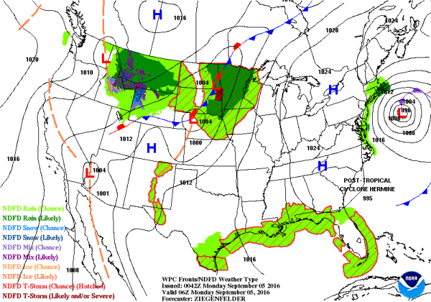
National Weather Outlook
The national weather outlook shows the remnants of Hermine off the East Coast, which in turn will have impacts across the rest of the nation. Tropical systems tend to have ripple effects on other weather systems, so things don't move along as quickly as they otherwise would. High pressure will linger a little longer across the Eastern Great Lakes across the Mid-Atlantic States, while unsettled, wetter weather will linger across the Upper Midwest.
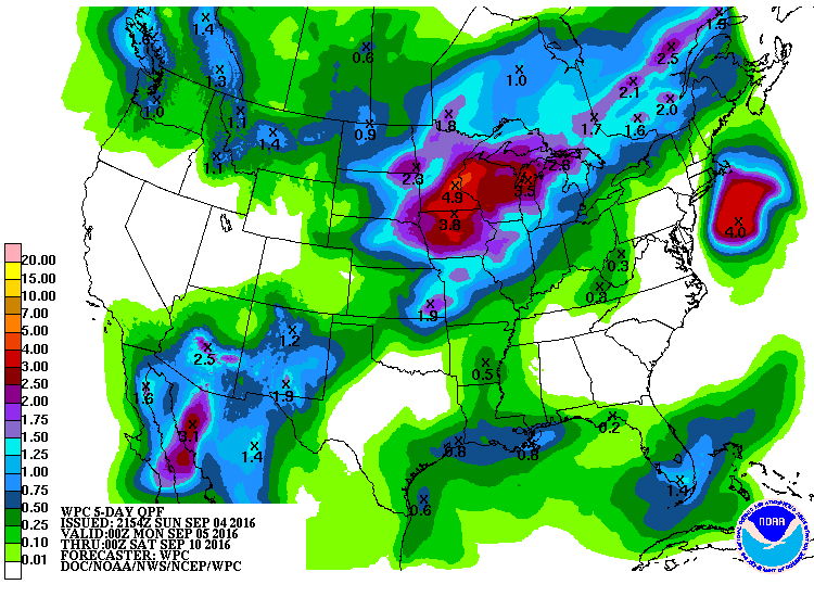
Precipitation Outlook
According to NOAA's WPC, the 5 day forecast suggests heavier rain associated with Hermine will stay mainly offshore. Meanwhile, several rounds of showers and storms will keep the threat of locally heavy rainfall in place over the Midwest through much of the week.
______________________________________
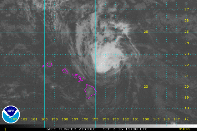
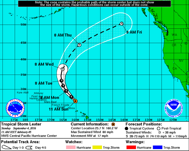
Lester in the Pacific
Here's a view of a much weaker Lester in the Central Pacific Ocean as it neared the Hawaiian Islands on Saturday. As of AM Sunday, Lester was a Tropical Storm and was well north of the Islands and was headed quickly north.
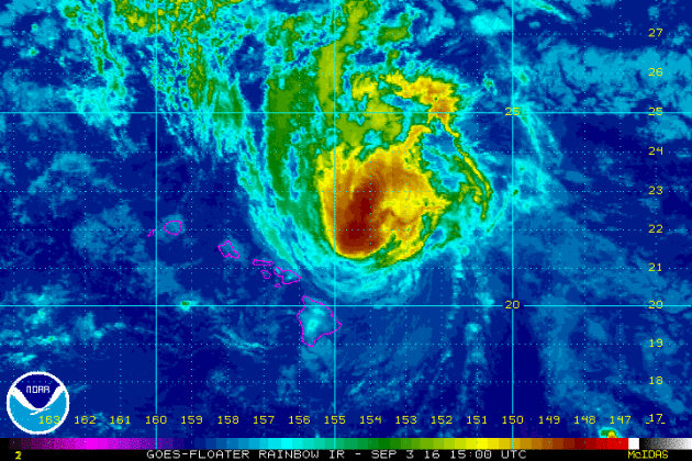
Tracking Lester
After making a close encounter with the Hawaiian Islands this weekend, the remnants of Lester will continue to drift north away from the Islands through the early week time frame. Interestingly, the remnants of Lester could make there way into the Upper Midwest by next weekend!
_____________________________________________
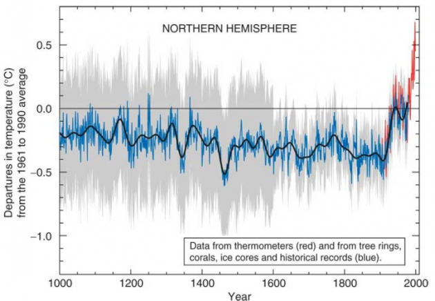
"Study Suggests Earlier Onset of Human-Driven Warming"
"To fully understand the warming of the planet that is being driven by human emissions of greenhouse gases, scientists need to examine the history of climate changes on Earth. Hampering this effort is the fact that direct measurements of temperature and other climate data only go back to about the late 19th century. But by using records kept by the Earth itself, that history can be extended back hundreds or even thousands of years. In a study published in the journal Nature, a group of researchers has knitted together such natural records — found, for example, in coral reefs, ice sheets and caves. They used those records to trace the thread of human-driven warming back to what they say is its beginning, nearly 200 years ago, when the coal-burning that took off with the Industrial Revolution was still revving up."
_______________________________________
"U.S., China Formally Join Paris Climate Pact"
"U.S. President Barack Obama and Chinese President Xi Jinping fortified commitments to reduce carbon emissions Saturday by formally joining the Paris agreement and pledging a “continued bilateral climate cooperation.” The leaders of the world’s two largest emitters of greenhouse gases met Saturday at the G20 Summit in Hangzhou, China. By officially ratifying the climate agreement reached in April, the two countries move the Paris deal a major step toward taking effect this year, the White House said. More than 170 nations signed the Paris agreement, committing to fight climate change by cutting carbon emissions. The deal requires at least 55 countries representing 55 percent of global emissions to take the additional step of ratification before it takes effect. Before Saturday’s action by the U.S. and China, 24 nations had formally joined, accounting for just 1.08 percent of total global greenhouse gas emissions, according to the United Nations. The addition of the U.S. and China boosts that to roughly 40 percent ― about three-fourths of the required total, according to the White House."

__________________________________________
Thanks for checking in and have a great end of weekend and week ahead!
Don't forget to follow me on Twitter @TNelsonWX
Don't forget to follow me on Twitter @TNelsonWX

No comments:
Post a Comment