78 F. high on Labor Day.
76 F. average high on September 5 in the Twin Cities.
89 F. high on September 5, 2015.
.51" rain fell at KMSP Monday.
September 6, 1922: A heat wave over Minnesota brings highs over 100 to southwest Minnesota. One of the hot spots is New Ulm with 105.
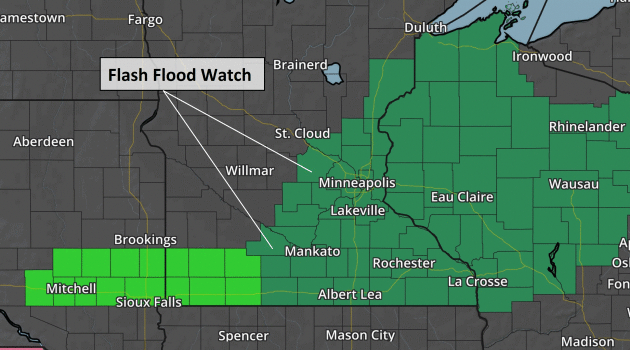
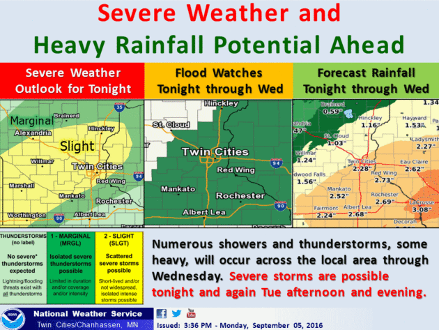
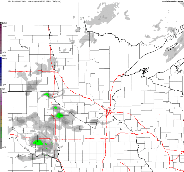
Flash Flood Watch as Weather Pattern Stalls Again
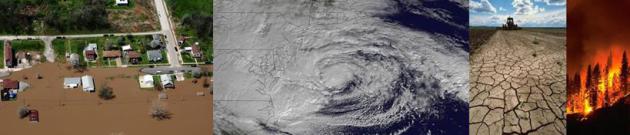
Implications of a warming atmosphere over Minnesota are fairly obvious by now: a longer growing season, milder, more erratic winters, more historic flash floods and a tendency for weather to become "stuck" for extended periods of time, with more blocking patterns in the atmosphere.
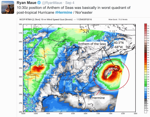
One such block is guiding "Hermine" westward, closer to the New Jersey coastline today, roughing up southern New England with tropical storm force conditions.
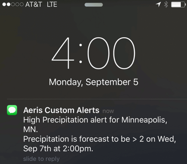
Ripples of low pressure rippling along a stalled frontal boundary will squeeze out more heavy rain for southern and eastern Minnesota and western Wisconsin into Wednesday night. NOAA has issued a Flash Flood Watch for 2-3 inches of additional rain falling on saturated soil. A squishy, lime-green landscape?
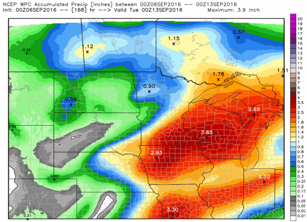
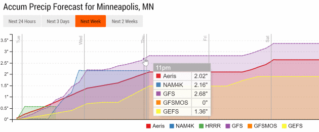
More June than September, and we are still very much on track for one of the wettest years on record for many Minnesota towns.
A ration of dry weather Thursday gives way to showers Friday, before a shot of cooler air arrives by Saturday. We'll see 80s the next few weeks. In fact I don't think we've enjoyed the last 90-degree day of 2016 yet, either.
* More details at Mashable.
Aeris Weather Briefings: Issued Monday, September 5th, 2016
* Post-tropical cyclone Hermine will continue to sit off the Mid-Atlantic coast over the next couple days, slowly drifting while interacting with another upper-level low that will nudge the system back to the north and west before finally being pushed out into the Atlantic and dissipating later this week.
* The largest threat from Hermine over the next couple days will continue to be storm surge/coastal flooding with lowland inundation near high tide. Life-threatening surf and rip currents will also occur.
* The heaviest rain will stay offshore, but 1-2” of rain is possible across parts of Massachusetts through Wednesday. The strongest winds will also remain offshore; however, some tropical storm force wind gusts will be possible across parts of Long Island, Connecticut, Rhode Island and Massachusetts.


High tide both this morning and evening on the New Jersey oceanfront is between 10:30 and 11:30. The storm surge in combination with high tide could lead to some localized road flooding. We will also keep our eye on the potential of more storm surge/coastal flooding heading into tomorrow as Hermine continues to slowly meander back to the west and northwest.


Summary: Hermine will continue to sit off the Mid-Atlantic coast as we head through the next 24-48 hours with 65-70 mph winds before eventually moving over colder waters and weakening. While the system remains offshore, we will continue to see impacts along the Mid-Atlantic and Northeast coasts with higher waves, storm surge/coastal flooding and beach erosion. Storm surge heights are likely to be between 1-2 feet above astronomical tides, bringing the potential of coastal and localized road flooding. Strong winds are also possible along and near the coast which could bring down some trees.
Meteorologist D.J. Kayser, AerisWeather
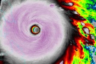
The Storm That Wouldn't Go Away. 15 minutes of fame, or is it 15 days of fame? Here's a great image from NOAA's Environmental Visualization Laboratory - Hurricane "Hermine" on September 1.
File image: Super Typhoon Haiyan, shortly before devastating the Philippines on November 8, 2013.

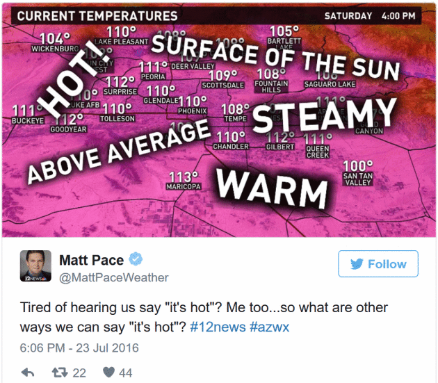
The Curse of a Phoenix Weatherman: Finding New Ways to Say "It's Hot". Matt, I feel your pain. Here's a clip from a tragically funny story at The New York Times: "There are certain unspoken talents required of television meteorologists in Phoenix, where the sun shines 296 days of the year
and temperatures exceeding 100 degrees faze no one. One such skill is
the ability to make the weather sound new each day. As a meteorologist
for 12 News, Phoenix’s NBC affiliate, Matt Pace
aims to make the recurring sunshine interesting, which is no easy task.
I’ve watched Mr. Pace on the air as he searches for just the right
words, from a limited list of options, to convey the very
straightforward fact that it is so darn hot outside..."

TODAY: Flash Flood Watch. Showers and T-storms likely. Winds: N 5-10. High: 77
TUESDAY NIGHT: Flash Flood Watch. T-storms, locally heavy rain. Low: 66
WEDNESDAY: Flash Flood Watch. More rain, heavy at times. Winds: NE 7-12. High: 75
THURSDAY: Squirts and spurts of mild sunshine. Winds: W 10-15. Wake-up: 62. High: 77
FRIDAY: Early showers, then cooler. Winds: NW 10-20. Wake-up: 60. high: 76
SATURDAY: Partly sunny, comfortable breeze. Feels more like fall. Winds: NW 10-15. Wake-up: 56. High:
SUNDAY: Sunny & warmer. Better lake day. Winds: S 10-20. Wake-up: 57. High: near 80
MONDAY: Sticky sun, PM T-storms rumble in. Winds: S 10-15. Wake-up: 63. High: 81
Climate Stories...
Where Will The Animals Go as Climate Change. Northward and uphill, according to research highlighted at Scientific American:
"The natural world is under siege by climate change. Rising
temperatures are pushing plants and animals outside their current range.
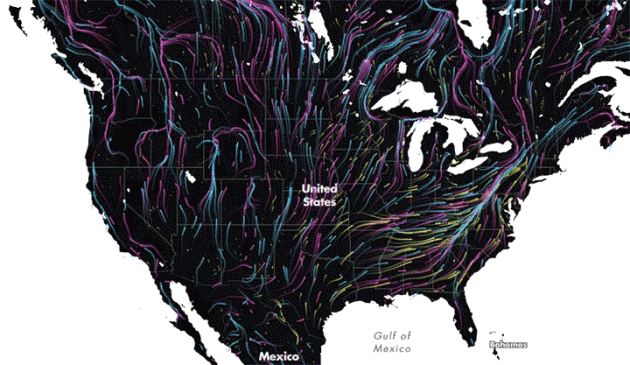
To keep pace with climate change, species will need a path to follow northward or up in elevation, minimally interrupted by human development. This map shows that path (well, paths actually) in the most beautiful way possible. It uses the dreamy Earth wind map for
inspiration. But rather than using temperature, wind and sea level
pressure data, Dan Majka, a web developer at The Nature Conservancy,
used data from two studies to show all the feasible paths that mammals,
birds and amphibians can use to find their way to a more suitable
climate as their habitat becomes too hot..."
Animation credit: "A
map showing the different pathways wildlife could use to migrate
northward or higher in elevation as the climate warms (red=mammals,
blue=birds, yellow=amphibians)". Credit: The Nature Conservancy
Climate Change Cynics: How to Effectively Communicate With A Denier. Here's an excerpt of a post at desmogblog.com: "...One
of largest barriers to convincing deniers and the apathetic alike is
the belief that climate change just isn’t something they will have to
deal with. In fall 2015, the Yale Climate Change Communication project
found that just 42 percent
of people believe that climate change will harm them personally. Even
sadder, that’s 6 percentage points higher than during the spring—a
promising trend but disappointing total reach. The more you can make
climate change an urgent, personal issue and show examples of how it’s
already harming health, wealth and communities, the better. You may
notice that when you receive emails from your favorite nonprofits,
they’re full of deadlines and short-lived opportunities. That’s not an
accident: creating a sense of urgency is an effective way to get people
to take action. The same applies when talking to doubters about climate
change. If you’re talking about health impacts, point to a child you
know who suffers from respiratory illness. If you’re using extreme
weather events to make your point, highlight the coming fire or
hurricane season..."
Did you know that you can shorten your long links with BCVC and make $$$$ for every visit to your shortened links.
ReplyDelete