81 F. high in the Twin Cities Tuesday.
76 F. average high on September 6.
83 F. high temperature at KMSP on September 6, 2105.
.86" rain fell yesterday as of 8pm.
September 7, 1986: A touch of winter is felt in northern MN, with lows of 20 degrees at Embarrass and 30 at Duluth.
September 7, 1922: The fifth consecutive day of 90 degrees or above occurs in the Minneapolis area.
By My Rough Calculations Today is June 99th
Why Minnesota? I can think of 11,842 good reasons. Our amazing roster of lakes has 44,926 miles of shoreline - more coastline than California's lakes and Pacific coast. We are blessed with an abundant supply of fresh water. Something Americans west of the Rockies don't take for granted.
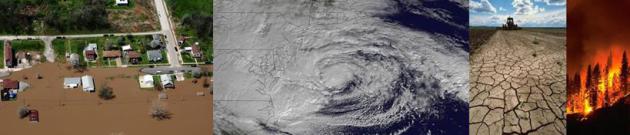
Lately there's been far too much water. Peering out my rain-splattered window at a neon-green lawn I'm sure it's June the 99th. From a climatological perspective we're on our fourth June in a row. This year June "monsoon season" never ended.
30 years ago scientists predicted that wet a
reas would get wetter; dry areas would trend even drier. That's what we're seeing on the weather maps.
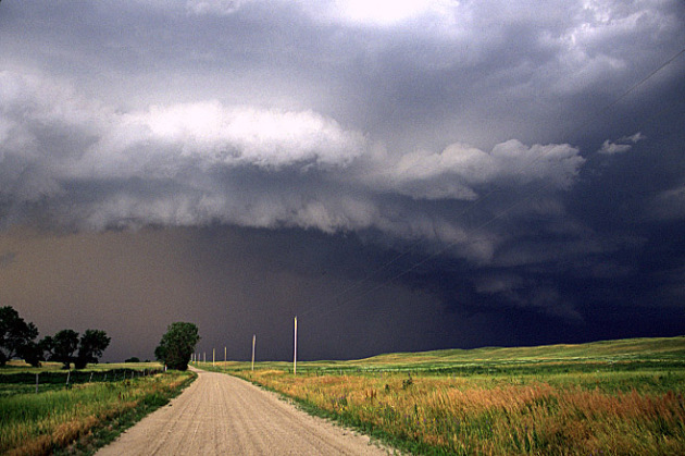
A Flash Flood Watch lingers today; a few more waves of heavy showers and T-storms, with another 1-2 inches of rain. A west wind dries us out Thursday with a ration of lukewarm sunshine. Showers flare up Friday before Canadian air has us reaching for sweatshirts Saturday.
Sunday looks warmer - a better day for the lake - a reminder that, at least on paper, September is one of the driest, most pleasant months of the year. Prove it, please!
Precipitation anomalies since June 1 courtesy of NOAA.
Hottest Summer? Snowiest Winter? Yes, Data Show Weather Is Getting More Extreme. Where have you heard that before. Here's an excerpt from The Boston Globe: "...According to the U.S. Climate Extremes Index, which considers both the frequency of extreme weather and how much land area is affected by such conditions nationwide, 2015 ranked as the second-most extreme year on record, trailing only 2012. Records date to 1910. The first half of 2016 ranked as the seventh most-extreme when compared with the same period in other years. The index is based on data on several key indicators: maximum and minimum temperatures that are much above or much below normal; how much of the country has either a severe drought or moisture surplus; single-day events with unusually high precipitation; and abnormalities in the number of days with, and without, precipitation..."
Graphic: NOAA NCDC.
Map credit: "Forecast track and actual track of Hurricane Joaquin in October 2015." Map: Dennis Mersereau.
Climate Change Spells Worse Typhoons for China, Japan: Study. Here's an excerpt at Yahoo News: "...Over
the past 37 years, typhoons that strike east and southeast Asia have
intensified by 12-15 percent," they wrote in the journal Nature
Geoscience. And the data showed this intensification, in turn, was
linked to ocean surface warming -- possibly caused by climate change,
though this is yet to be proven. Projections for ocean warming if humans
continue to emit planet-harming greenhouse gases, said the team,
"suggest that typhoons striking eastern mainland China, Taiwan, Korea
and Japan will intensify further..."
Photo credit: "The
world's nations concluded a pact in Paris to halt the march of climate
change, which threatens stronger storms, longer droughts and
land-gobbling sea-level rise." (AFP Photo/Tokachi Mainichi)
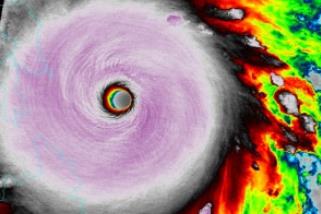
File image: Super Typhoon Haiyan, shortly before devastating the Philippines on November 8, 2013.
Thunderstorms, Hail and Flooding Drive Weather Losses for First Half of 2016. Here's a clip from Yahoo Finance that got my attention: "...Texas
absolutely drove the catastrophe losses in the United States during the
first six months of 2016,” said Bove. “Of the $17 billion in economic
losses and $11 billion in insured losses, approximately 80% of both the
over and insured losses occurred within Texas, of which roughly $7
billion of the insured losses were due to severe thunderstorm events.”
Bove also highlighted the floods in West Virginia, which he said the
National Weather Service and NOAH consider to be a 1-in-1,000-year
event. However, Bove said he believes that the one catastrophe that is
increasing losses is hail..."
Extreme Temperatures Could Increase Preterm Birth Risk. Here's an excerpt from Curated Health, Medical and Science Updates: "Extreme
hot or cold temperatures during pregnancy may increase the risk of
preterm birth, according to study by researchers at the National
Institutes of Health. The study authors found that extremes of hot and
cold during the first seven weeks of pregnancy were associated with
early delivery. Women exposed to extreme heat for the majority of their
pregnancies also were more likely to deliver early. The researchers
found more consistent associations with early delivery after exposure to
extreme heat than to extreme cold weather..."

Photo credit: "Grocery store employee Talia Pershall placed bottles of syrup back on a shelf on Saturday at White’s Foodliner in Pawnee, Okla., after an earthquake." Credit David Bitton/The News Press, via Associated Press.

The Curse of a Phoenix Weatherman: Finding New Ways to Say "It's Hot". Matt, I feel your pain. Here's a clip from a tragically funny story at The New York Times: "There are certain unspoken talents required of television meteorologists in Phoenix, where the sun shines 296 days of the year
and temperatures exceeding 100 degrees faze no one. One such skill is
the ability to make the weather sound new each day. As a meteorologist
for 12 News, Phoenix’s NBC affiliate, Matt Pace
aims to make the recurring sunshine interesting, which is no easy task.
I’ve watched Mr. Pace on the air as he searches for just the right
words, from a limited list of options, to convey the very
straightforward fact that it is so darn hot outside..."

TODAY: Flash Flood Watch south/east of MSP. Heavy showers, T-storms. Winds: E 5-10. High: 75
WEDNESDAY NIGHT: Showers begin to finally taper. Low: 61
THURSDAY: Rare sunshine sighting expected. Winds: W 10-15. High: 76
FRIDAY: Some sun, risk of a few showers. Winds: S 8-13. Wake-up: 60. High: 75
SATURDAY: Partly sunny, a fresh breeze. Winds: NW 10-15. Wake-up: 57. High: 71 (60s for most of MN)
SUNDAY: Sunny, breezy and warmer. Winds S 10-20. Wake-up: 56. High: 79
MONDAY: Mild start, then cooling off as clouds increase. Winds: NW 10-15. Wake-up: 63. High: 76
TUESDAY: Few showers, feels like fall! Winds: N 10-15. Wake-up: 56. High: 62
Climate Stories....

Photo credit: "At the City Market in Charleston, S.C., one of the most popular spots in town, shoppers dodged seawater that bubbled up from storm drains during high tide in June." Credit Hunter McRae for The New York Times.
Sea Level Rise Puts Mid-Atlantic in Greater Damage When Storms Like Hermine Strike. Andrew Freedman provides more perspective at Mashable.
Photo credit: "Water from Roanoke Sound pounds the Virginia Dare Trail in Manteo, N.C., Saturday, September 3, 2016 as Tropical Storm Hermine passes the Outer Banks." Image: Tom Copeland/AP.
Image credit: U.S. Army/Public Domain.

Where Will The Animals Go as Climate Change. Northward and uphill, according to research highlighted at Scientific American:
"The natural world is under siege by climate change. Rising
temperatures are pushing plants and animals outside their current range.
To keep pace with climate change, species will need a path to follow northward or up in elevation, minimally interrupted by human development. This map shows that path (well, paths actually) in the most beautiful way possible. It uses the dreamy Earth wind map for
inspiration. But rather than using temperature, wind and sea level
pressure data, Dan Majka, a web developer at The Nature Conservancy,
used data from two studies to show all the feasible paths that mammals,
birds and amphibians can use to find their way to a more suitable
climate as their habitat becomes too hot..."
Animation credit: "A
map showing the different pathways wildlife could use to migrate
northward or higher in elevation as the climate warms (red=mammals,
blue=birds, yellow=amphibians)". Credit: The Nature Conservancy
Climate Change Cynics: How to Effectively Communicate With A Denier. Here's an excerpt of a post at desmogblog.com: "...One
of largest barriers to convincing deniers and the apathetic alike is
the belief that climate change just isn’t something they will have to
deal with. In fall 2015, the Yale Climate Change Communication project
found that just 42 percent
of people believe that climate change will harm them personally. Even
sadder, that’s 6 percentage points higher than during the spring—a
promising trend but disappointing total reach. The more you can make
climate change an urgent, personal issue and show examples of how it’s
already harming health, wealth and communities, the better. You may
notice that when you receive emails from your favorite nonprofits,
they’re full of deadlines and short-lived opportunities. That’s not an
accident: creating a sense of urgency is an effective way to get people
to take action. The same applies when talking to doubters about climate
change. If you’re talking about health impacts, point to a child you
know who suffers from respiratory illness. If you’re using extreme
weather events to make your point, highlight the coming fire or
hurricane season..."
No comments:
Post a Comment